


Vikos
-
Posts
839 -
Joined
-
Last visited
Content Type
Forums
Blogs
Gallery
Events
Learn About Weather and Meteorology
Community guides
Posts posted by Vikos
-
-
1 minute ago, Skullzrulerz said:
Not to mention we have this shortwave business to get around too as well
Starting to think that this run in general has pushed the cold back sightly
Classic GFS-style for me: predicting smthg big in fi, than swinging back or delaying it with every new run a bit more, until just a cold fart remains. Only hope: the big patterns this season are quite better then the last years have ever been...
-
 2
2
-
-
Well, Santa might be freezing on this one

-
3
-
-
Well, cold isn't the only thing...
For my place, we could have that Coca-Cola-Commercial XMAX-Eve Snow (maybe above 300m)
-
2
-
-
Will it split?!
-
2
-
-
For me, the most significant thing this season is this massive cold block to the east and the lack of cold air over Canada. If this block starts moving westwards, than, oh boy oh boy...
-
5
-
-
Good morning!
I haven't read all pages since yesterday evening, so may I repeat this, but is there a chance for a SSW? A minor for sure...
-
3
-
-
Why I think that this year the setup is a lot better for cold (and maybe snow) spells is the fact, that the main cold air block this year is on the opposite side of the NH. So for me this is a big pattern change, hopefully the cold doesn't shift over the pole towards Canada this year (to initiate a very strong west drift)
versus last year (same date) -
5
-
-
6 minutes ago, Tim Bland said:
12z not as good as the 06z for amplification in the Atlantic unfortunately (see below for comparison) Hopefully Xander will do an analysis of all 30 ensembles later ...
If you would compare to yesterdays 12z that would be way better for analysis, due the fact that 06z and 18z differ in (less) data input as as I know.
-
1
-
-
5 minutes ago, That ECM said:
When searching past t144 and into fi we are looking for big picture type changes and trends. Details will be impossible of course but if heights are being modelled be it west of us over us or east of us then it is of interest to see if any can get further north.
But the comparision must be made with the charts from the preivious day like 00z to 00z. Comparing 00z to 06z f.e. doesn't make any sense due the lack of a lot of information in the runs of 06z and 18z (mostly radio probes information that is missing in 06 an 18z).
Correct me if I am wrong (and excuse my maybe freaklish english)
-
Comparison 6z GFS today / yesterday
It's swinging...
Just to show that there is no sense to search anything past 144h, my oppinion...
-
7
-
 1
1
-
-
Question: Is GFS still bias'ed with calculating too much atalntic power?
-
1 minute ago, alexisj9 said:
It's that dry cold air that helps us here lol, it goes over the North sea, picks up moisture, and dumps it on eastern UK as snow, but only if Europe is cold obviously.
Yes, some nice Lake Effect snowfalls is the cherry on that cup cake
-
1
-
-
3 minutes ago, Valleyboy said:
To be fair, it’s only easterlies that really deliver the goods, for most of the UK, so let’s hope models firm up on the real deal. Remember, the models have never handled easterlies well, they tend to appear at short notice.
Easterlies deliver more like bone-dry continental cold, what we need is more like N-NE with moisture. At least for my position (Germany)
-
1
-
-
Just now, danm said:
There's nothing worse than a Spring like Xmas day.
Still, patience is key. We rarely have white Christmases in this country and there's still most of the winter in front of us.
Last year I've been in Florida for XMAS and NY and I can tell you, it's not that bad having a xmas-bbq at 28°C
-
1
-
-
Like all the years before, XMAS-BBQ outside in the garden with a T-Shirt and a cold beer...
-
3 minutes ago, Updated_Weather said:
I think we can all agree the GFS has no idea at the moment? xD
Who has those days?
-
Aslong as there is no significant change in the rossby wave pattern in any foreacast-modell, there is minimum hope to get some realiable cold spells to mid-europe soon. The jet is not showing any good amplitude changes...
We need smthg like this
My regards from boring Germany
-
1
-
-
What we need
What we actualy have
Right now, we can only pray to the god of snow...
-
11 minutes ago, Daniel* said:
Not sure why people are jumping to conclusions we’ve known for quite some time it will turn more unsettled and a pathway wouldn’t be immediate unless you take single op as a gospel. The Arctic high hasn’t even formed yet, we aren’t sure about the level of blocking, if there’s going to be a split to PV or not. Need I go on? Tamara said watch for AAM trends I’m not sure what that’s doing, but it’s possible if we see a + surge then the level of blocking would be underestimated in late December. Plus don’t forget the MJO there’s a lot of uncertainties here which we aren’t sure of. Saying weeks of winter is lost is very premature.
AO forecasts continue to go more negative.. suggests unstable polar field to me, very not easy to forecast.
That is just the right answer to all persemistic posts here! Like "think big!"... the patterns this season are better then the last years, so we just need to chill a bit. A early start with cold and snow wasn't always that good TBH, it's like shooting all of his powder at once. Rember 2010, very good winter, but then total fail from January on...
Regards from Germany
-
6
-
-
But, will it SPLIT
-
1
-
-
50 minutes ago, karyo said:
Will this warming happen though or get watered down again?
Could be the FINAL MW which happens often @ the end of met. winter time
-
2
-
-
That massive cold block over Arctic Siberia and the vanished Canada PV cold looks decent to me
-
1
-
-
It's all down to EC now to make it a Straight Flush or just a simple pair
-
Winter...


 versus last year (same date)
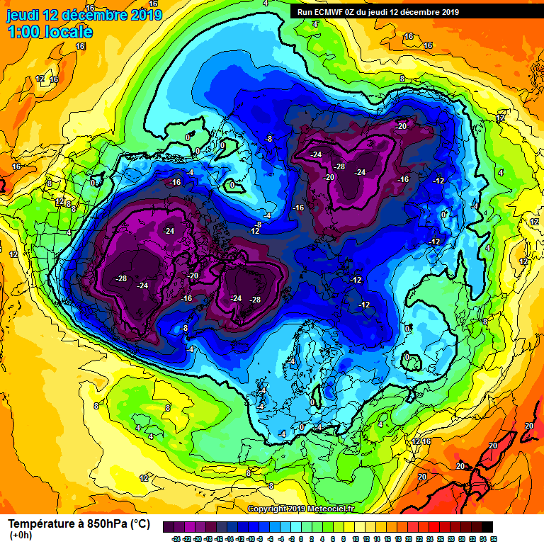


Model output discussion - Closing in on Christmas
in Forecast Model Discussion
Posted · Edited by Vikos
I like this1050 greenland high...