


Cloud 10
-
Posts
5,269 -
Joined
-
Last visited
-
Days Won
1
Content Type
Forums
Blogs
Gallery
Events
Learn About Weather and Meteorology
Community guides
Posts posted by Cloud 10
-
-
Nice to see some decent cold uppers at the backend of the 06z ens.mean.

-
 4
4
-
-
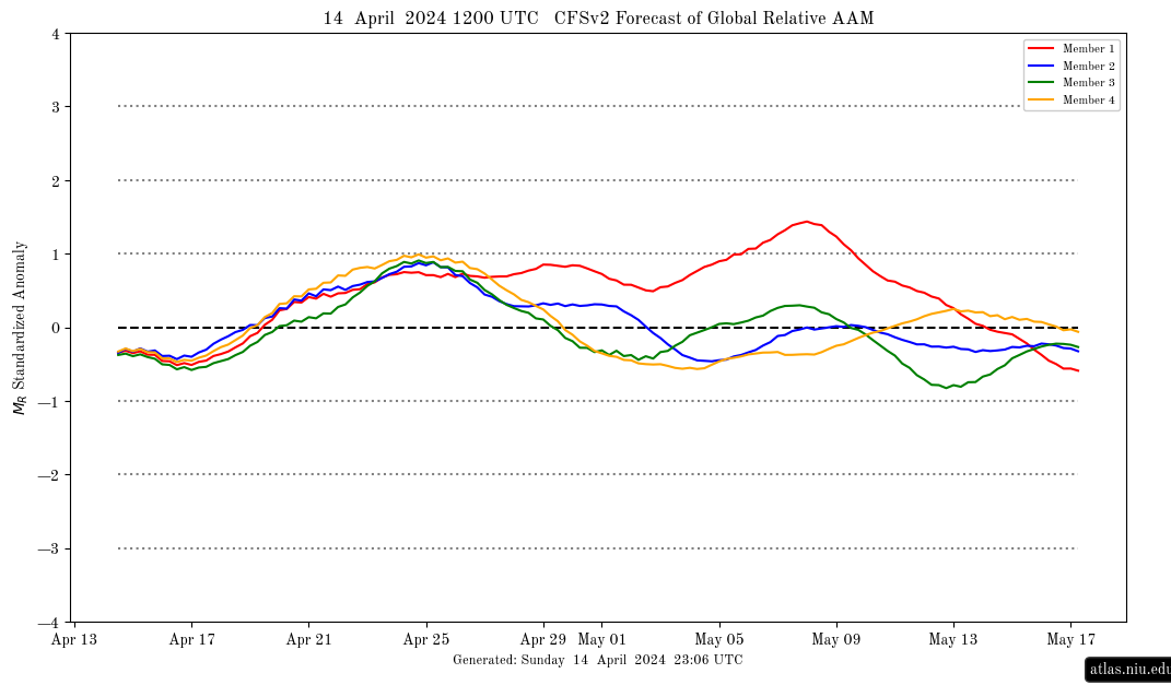
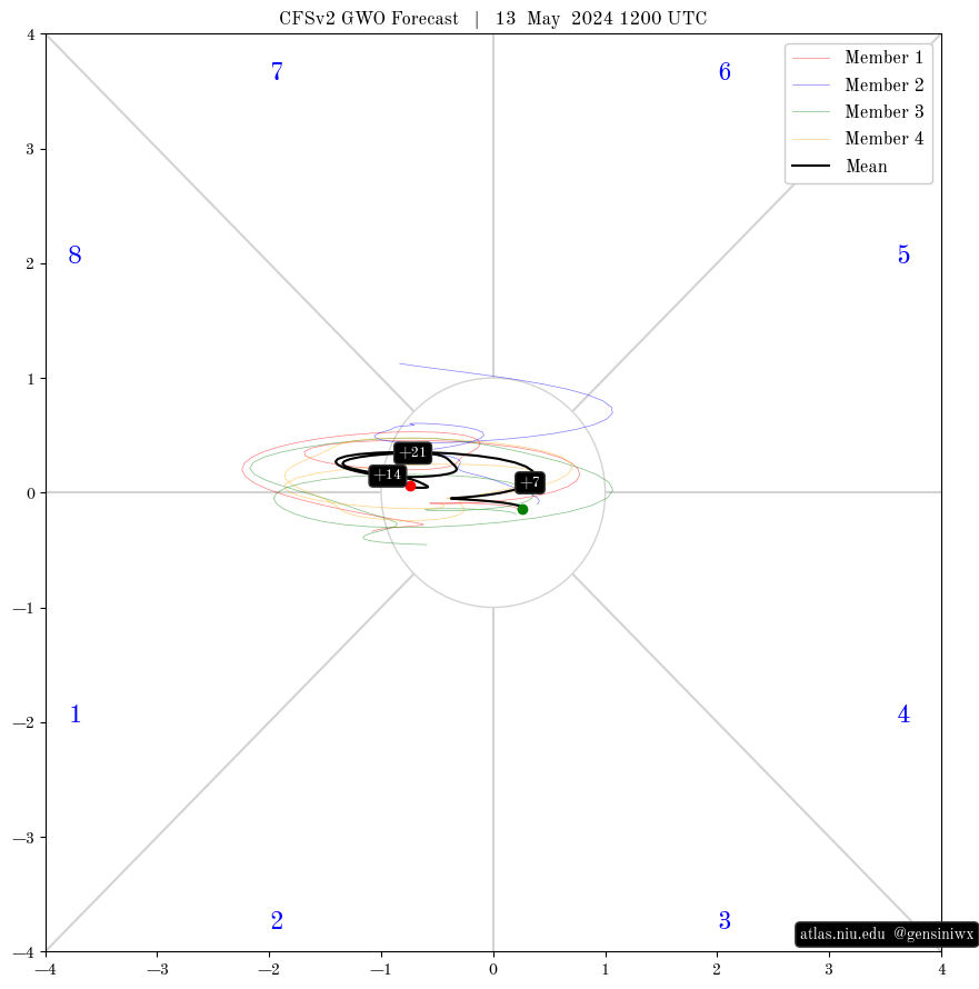
AAM/GWO forecasts are a bit thin on the ground,but found these for anyone interested.
https://atlas.niu.edu/forecast/aam/cfsv2_aam_fcst_current.png
https://atlas.niu.edu/forecast/aam/GWO_members_current.png
Both from this page: https://atlas.niu.edu/gwo/
-
1
-
 2
2
-
-
Got moderate snow here giving a thin slushy covering.
-
1
-
-
First few tiny flakes here.
-
Quite a hard frost this morning,temps. in minus double digits over parts of Scotland.
-
- Popular Post
- Popular Post
-
12
-
The pressure anomaly ens. means look great for the end of week 2 (ECM very similar) but patience (yet more!) may be needed to get some decent cold dragged in.
-
2
-
-
The models seem very reluctant to clear the troughing East and we end up with a Nick Sussex
"shortwave frenzy"

-
1
-
-
-
12z UKMO precip charts rolling out now.
https://www.meteociel.fr/modeles/ukmohd.php?map=10
Also stonking Fi from GFS.
-
8
-
 1
1
-
-
As noted by others,a big lunge south for Thursday's low from the 12z UKMO,especially when compared with yesterday's.
today's.
yesterday's.
-
6
-
-
-
3
-
-
Increasingly likely for a major snow event somewhere across the UK towards the end of next week,and as noted above these events are often modelled to far North.
-
- Popular Post
- Popular Post
GEM 12z ens. mean seems to be super-keen on big Greenland height rises towards the end of week 2 and is a "stonker" for a mean chart at that range.
-
13
-
A bit off topic,but just sharing this webcam posted on the Norway storm thread.
-
1
-
3
-
-
Icon has 120mph+ gusts slamming into western parts of Norway.
https://zoom.earth/maps/wind-gusts/#view=61.4,9.5,4z/date=2024-02-01,00:00/model=icon
-
2
-
-
-
6
-
-
- Popular Post
- Popular Post
Possibility of a historic storm event for Northern Scandi next week with +100mph gusts easily.
https://www.meteociel.fr/cartes_obs/gens_panel.php?modele=0&mode=1&ech=90
Some GEFS down to 915mb.
-
10
-
Worst of the wind looks to be starting around now until the early hours of the morning.

-
North of Scotland getting hammered at the moment,maybe we can get lucky with an organised band of showers in the early hours.
-
Looks like Tamara can get the sun lounger back out next week.

-
2
-
-
Managed a dusting of snow here today but now raining lol.
-
Scraping the bottom of the barrel regarding technical SSW's,but there it is!
Should be plenty of interest to come heading through the next few months with a weak looking strat.
-
-
6
-


Model Output Discussion - Spring Has Sprung
in Forecast Model Discussion
Posted
The models are keen on a deep trough dropping down from the NW later next week,so the next named storm could be on the cards.