


NorthYorksWeather
-
Posts
2,917 -
Joined
-
Last visited
-
Days Won
2
Content Type
Forums
Blogs
Gallery
Events
Learn About Weather and Meteorology
Community guides
Posts posted by NorthYorksWeather
-
-

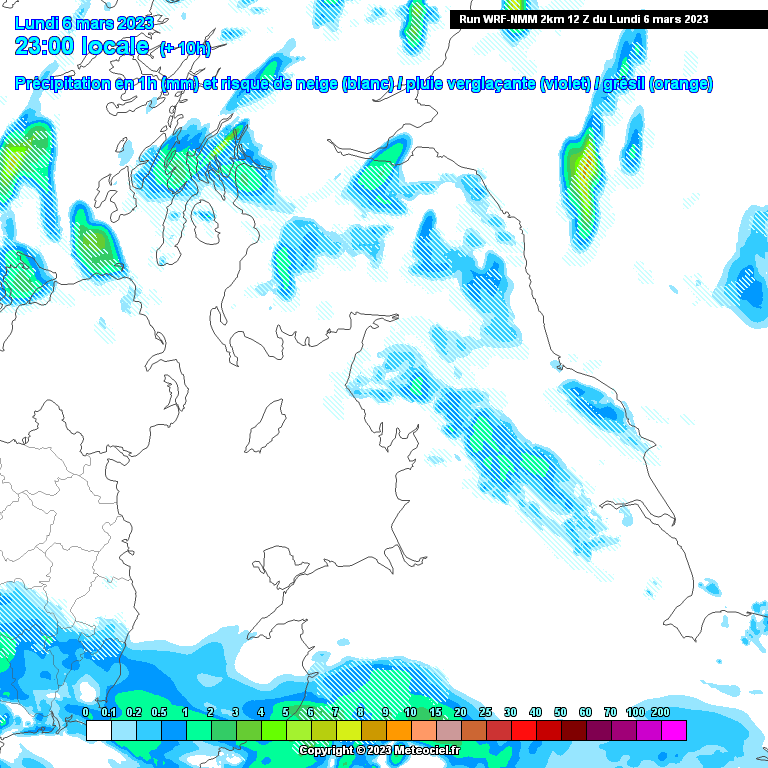
Quick look at tonights snow shower forecast from the WRF NMM.
Several inches likely for the parts of the North York Moors and Yorkshire Wolds.
I feel I might be a bit too far west to catch any showers as the winds are slightly west of north but happy to be proven wrong.
Few members on here possibly seeing some snow @Jeremy Shockey @Wold Topper @Aiden2012 @reef
1 minute ago, yaffle said:I'm back at work on Friday so i'm hoping for a decent covering Friday into Saturday. Not expecting much for Strensall though.
Fylingdales will be fun tonight!
-
 2
2
-
-
Bit of snow over top of Moors this afternoon whilst at work. Snow showers now making a b-line for the Yorkshire Coast, quite a bit of snow likely overnight for the same folk in December who saw a lot of snow around the Whitby/Scarborough area. Really has been a great winter for those on the coast with a few inches that lasted a week in December, a covering in January and some more tonight.
-
3
-
-
Slightly disappointed to see the trend moving away from a North Easterly aspect to the flow that was modelled quite widely over the last few days, especially for Mon night into Tuesday. Those juicy convective showers and any possible disturbances moving across eastern areas into central regions have now disappeared with the models just showing showers grazing eastern coasts as what happened back in December. ECM does still keep some hope but the 6z UKMO shows the flow due north to slightly west of north.
-
3
-
-
NMM Hi res model just coming into range for the low pressure off the east coast of Scotland on Monday evening.
An organised band of heavy snow moving into NE Scotland.
-
3
-
-
18z GFS has a deeper low running down eastern areas on Tuesday morning giving an more organised band of snow sweeping southwards across the country.
Likely blizzard conditions over the North York Moors and exposed coastal areas.
ICON however has no low whatsoever with just a clean convective cold flow off the North Sea.
Both UKMO and EC have this low so ICON on its own there.
-
7
-
 2
2
-
-
5 minutes ago, Aiden2012 said:
Now that would be the perfect end to winter for me

 had no laying snow all winter
Me either Aidan here near Malton not far from you, narrowly missed out back in December whereas only a few miles east saw a good dumping.
GFS is dream event for us that are snow starved. Unfortunately its a long way off so probably likely to chop and change a lot between now and then.
Looks like round 2 incoming at 216hrs but this one likely to be a snow to rain event.
Certainly feel a bit more positive after the 12z EC and 18Z GFS after a poor 12z ICON/UKMO/GFS.
Hopefully the 00z's prolong the cold spell.
-
8
-
1
-
-
1 hour ago, damianslaw said:
Says it all this thread has been inactive since 25th January, the period since being largely mild or very mild with a few cold nights but nothing out of the ordinary. We may well see very cold minima in March, but suspect we have seen the coldest min of the season now, and an early one this year.
Please can someone post the coldest min this season England, Wales and Scotland.
I appreciate you will be looking for official data but amateur wise Lee from Highland Weather recorded a low of -20.0C in December last year in Schillochan, near Carrbridge in the Highlands.
-
28 minutes ago, KTtom said:
ECM / GEM sticking together with a sinker stinker! If were not getting cold, may as well have this as we head into week 2 March..
18 minutes ago, Lukesluckybunch said:Well you really couldn't make it up..ECM for once looked decent 168-192 ..you would think it would get even better after in fact it got worse..consistency is very poor at the moment the trend from a few days ago..seems to be fading in my opinion.
Surprised at such negative comments regarding the ECM this morning. It’s a huge improvement to last nights run, especially in the short term and if you look at the 216-240 timeframe it’s likely the colder air to the NE will filter our way as the low to the west spawns a shortwave across towards Scandi which would acts as our “trigger low” to advect the coldest air over Norway towards us. GFS has shown the scenario a handful of times over the last couple of days so perhaps we are seeing some agreement on how we MIGHT manage to advect some decent cold air our way.
UKMO is similar to the EC this morning which is good news, fingers crossed for some further upgrades as the day progresses.-
6
-
 2
2
-
-
44 minutes ago, christhe said:
Evening
I am new here and interested in getting a weather station.
I am limited in both cost approx £100 and ability to mount anything externally, so an external Anenometer is out of the question sadly.
Can anyone recommend any possible options?
What are peoples thoughts on the Netatamo Weather station? - whilst i am aware its more than £100 it ticks some of the boxes
Thanks
Chris
Good evening. I own around 40 weather stations in total and have used many different types of stations over the years.
Here are my top pick with your price range:
Ventus W830 Weather Station WiFi Internet & Colour Forecast
WEATHERSPARES.CO.UKThe Ventus W830 weather station allows you to monitor your weather remotely as it uploads data to Weather Underground, Weather Cloud and also the UK MetOffice...https://cpc.farnell.com/pro-signal/psg04173/weather-station-wifi/dp/IN08375
From experience the worst station at the £100 mark I have ever used is Bresser so I wouldnt advise purchasing this brand.
Hope this help, Vizzy
-
59 minutes ago, Weather-history said:
Hi vizzy
Equation is
10 x [(the number of days with lying snow)+(number of days with falling sleet/snow)+(number of days where the temperature has been at or below 0C)] divided by the mean maximum temperature.
You could use your data from you own weather station or you could use your closest official weather station or one of those you see on wunderground
Met Office WOW - Home Page
WOW.METOFFICE.GOV.UKThe UK Met Office Weather Observation Website (WOW). WOW allows anyone to submit their own weather data, anywhere in the world.Thanks. Is it strictly winter Dec-Feb or is it Autumn to Spring?
I imagine it will be quite low this winter as we have had no snow falling nor settling, quite a few days below 0 though.
-
3 minutes ago, Weather-history said:
Manchester Winter Indices ranked
2013-14: 7
1988-89: 20
2006-07: 21
1997-98: 25
1974-75: 26
1989-90: 26
2015-16: 28
2021-22: 28
2019-20: 29
1973-74: 30
1987-88: 37
2007-08: 37
2016-17: 37
1991-92: 40
1975-76: 41
1999-00: 42
1992-93: 43
2002-03: 44
1994-95: 45
2018-19: 45
1998-99: 47
2004-05: 47
2011-12: 47
2001-02: 50
2003-04: 50
2022-23 : 55 (6th Feb)
2005-06: 59
1979-80: 66
1996-97: 72
2000-01: 77
1993-94: 78
1983-84: 82
2014-15: 82
1982-83: 85
1977-78: 90
1980-81: 90
2017-18: 93
1986-87: 100
2012-13: 102
2008-09: 105
2010-11: 119
2020-21: 120
1990-91: 126
1995-96: 135
1984-85: 140
1976-77: 141
1981-82: 149
1985-86: 159
2009-10: 197
1978-79: 262
Hi Kev is there somewhere where I can see how your index’s are calculated as id like to start doing something like this in the future. Thanks
-
My coldest stations are just nudging -8°C now, with lots at -6/7°C. Most of which have some snow cover but not all of them. Wonder if we can make it to -10°C?
-
3
-
-
Just now, Wold Topper said:
Mixed in with a bit of now casting and lamp post watching, although if it happens it will be nearer breakfast time if ure an early bird,

Yeah I'm heading to work 5.30am just outside Malton.
Plenty of showers forecast for our area later Weds/Thurs but milder 850s are dragged in off North Sea so looks like rain.
-
1
-
-
Well only a few hours out and all the models still can't agree on the track of any precipitation tonight.
The warning from the Met Office is quite a large area which suggests to me they have no clue either, looks like a good old fashioned radar watch overnight and keep everything crossed.
-
3
-
-
Latest forecast for tonight from the NMM. The track has remained the same but looks like there is less intensity which isn't good news for those lower down.
-
1
-
-
53 minutes ago, Jeremy Shockey said:Promising ........but will be a nowcast i think ( and marginal for low ground )
I suppose we have the time of day on our side. Very early morning, just need to hope precipitation is quite heavy to bring the snowline down.
The Met Office do mention they are not expecting snow to low levels but could turn to snow in heavier or prolonged showers.
-
Worth noting there is still model disagreement regarding the track of this feature tonight even less that 24 hours away.
The UKMET model for example doesn't even get it north of Sheffield.
-
1
-
-
-
58mph recorded in the village here on a weather station and only 65m asl.
as Wold Topper said Hasty Bank at 80mph and Loftus near Whitby has hit 74mph. Wildest night for some time.-
2
-
-
-7.1°C overnight here, the lowest since Feb 2021. Most of the snow showers east of here but managed to clip one earlier giving the slightest of sugar dustings. Inland elevated areas near the coast are getting some good snow totals by sound of it.
-
2
-
-
NMM showing wintry showers moving down across eastern areas tomorrow morning, probably a mix of rain sleet at low levels/coast but inland with a bit of elevation might see some surprises.
-
1
-
-
Bit of sleet on North York Moors today above 400m.
These showers should be turning to snow up there as the night progresses, back home near Malton its rain showers at 3.5c.
-
1
-
-
On 03/12/2022 at 20:16, mike57 said:
I wonder if we will see snow at the coast. Sea Surface Temp is still at around 10c this may be a bit to high to allow snow here. Having said that December 2010 was deepest snow here over the 16 years we have lived here, it just kept piling up. I wonder what SST was at the start of Dec 2010
Think I saw a chart posted area showing late Nov 2010 has north sea temps of around 8-9c so marginally colder than now.
An interesting week coming up, not looking like much snow depth wise but a few places could see a covering plus some low overnight minimas, especially where we have snowcover.
All my weather stations are poised and ready to record some low temps, hopefully this thread is nice and busy come end of the week.
-
4
-
-
The main difference with the ICON this afternoon is more noticeable on the NH view. Big changes the other side of the Arctic with the PV.
0z
12z


Yorkshire and E England regional discussion
in Yorkshire & E.England Weather Discussion
Posted
Yes thats always the issue. The Moors often gobbles the showers and the likes of Malton, Stamford Bridge/ Pock are left with scraps. We may be slightly too far inland but i wont throw in towel until tomorrow morning.
Il be on Moors by late morning so hopefully see some snow if we miss it here.