


lorenzo
-
Posts
4,875 -
Joined
-
Last visited
-
Days Won
25
Content Type
Forums
Blogs
Gallery
Events
Learn About Weather and Meteorology
Community guides
Posts posted by lorenzo
-
-
Solid grey and white skies here ,steady rain and a light to moderate wind. Enough to make the trees in full foliage sound awesome.
-
 1
1
-
-
Some active weather on the way... Beats watching the drivel my daughter is watching on TV, latest obsession is Catfish. Total mince !

Nice video here from Jo detailing the predicted impact areas.
The focus on the air mass changes mentioned in the Meto vid earlier in the thread really clear on the NMM runs as Sunday progresses.
Afternoon fax has this one at 966mb, to a fairly quick drop, not a really huge bomb laden with sting jets but against the benign conditions which have prevailed for some time will feel like a step change to Autumn.
With Humberto to follow.. cracker of a name that, lol !
Video Reel Here http://www.yr.no/satellitt/europa_animasjon.html
-
5
-
-
SS - proper quality.
I hope you have employed Scorcese this year to track the tyre adventures.
PS Remember to include further French Expletives the residents liked that !
-
1
-
-
Fond memories of this one. Football match abandoned. Car Journey home abandoned.An absolute pasting of snow for North East Scotland. Power Cuts, Blizzards, everything..everything..
-
3
-
-
Can't get the sound on that clip but I agree there's not many more satisfyingly brutal sounding aircraft. My Airfix model was a favourite too.
The sound on this one is astonishing, really get a good idea of the Vulcan 'Howl' as it's fondly known. Have you tried opening in You Tube rather than the embedded one?
-
1
-
-
Looks like this pulse of rain ebbs NNW cheggers, wet start to the day and drying out as the morning progresses.
Some cloud around, the yrno map run indicates some clear skies from around 11-mid-day through the afternoon before more rain in the evening.
http://www.yr.no/kart/#lat=65.00146&lon=19.54158&zoom=3&laga=nedb%C3%B8rskyer&proj=3575
Am very Jealous ! Nothing better than hearing the noise an Avro Vulcan serves up !
-
2
-
-
Good Morning Gabrielle.
I fear for my username this month, hope L if it develops is indeed a fish.
-
No - I was too tight to pay as the info normally comes to light eventually.
FWIW, even though we are entering a theoretical solar max - it is a very half hearted one - so I don't know whether we can expect a significantly enhanced BDC from the link between the wQBO and solar max.
Looking at the info. in that paper there are a few good scatter graphs that highlight the years relevant to precisely that point and of course this graph,
I like page 14 as it puts things quite simply, might need to look for that Holton and Tan paper for a read. So could we say without the Solar Max reaching previous levels there is not an over-riding signal for a very strong vortex profile with respect to what the BDC is doing. If you want to confuse people put slide 23 up that makes the point that in Solar max both QBO phases are dampened. Re QBO Raw Data 1990 is worth a look for similarities. 2013 out there with some strong figures already.
-
3
-
-
Good shout SS, it was touch and go for a bit but eventually made it. Advisory updated now. http://www.nhc.noaa.gov/graphics_at2.shtml?gm_track#contents
http://radar.weather.gov/ridge/radar.php?rid=JUA&product=N0R&overlay=11101111&loop=yes
Some 18z model guidance courtesy of the good Dr. on Twitter.
-
Essentially what Chiono has paraphrased the extract to Jonboy. It means we can look right at the top of the Stratosphere for warming pulses.
Ed, did you get a hold of that paper by Labitzke?
I googled it and it's behind a wiley journal paywall, at a stunning $42 dollars for 24 hrs access !
Did find this one though from 2008 with some useful analogs and tables, a forerunner am sure to what has just been published.
http://solar.physics.montana.edu/SVECSE2008/pdf/labitzke_svecse.pdf
-
2
-
-
New Acronym alert and I wondered when we would see a paper that brought the mesosphere into things.
USLM - Upper Stratosphere Lower Mesosphere.
http://onlinelibrary.wiley.com/doi/10.1002/jgrd.50289/abstract
This work presents a climatology of synoptic-scale disturbances in the upper stratosphere lower mesosphere (USLM) based on 20.5 years of assimilated data analyses from the U. K. Meteorological Office (1991–2012). USLM disturbance criteria are established, based on stratopause warmings at the 2 hPa level, to create climatologies in both hemispheres that delineate their timing, frequency, and geographic location. USLM disturbances occur on average 2.3 times per winter in the Northern Hemisphere (NH) (November through March) and 1.6 times per winter in the Southern Hemisphere (SH) (May through September), persist on average for 8 days in the NH and only 4 days in the SH, occur most frequently in December (July) in the Northern (Southern) Hemisphere, and are predominantly located in the longitude sector between 0oE and 90oE in both hemispheres. This is the first work to show that all major Sudden Stratospheric Warmings (SSWs) over the 20.5 year data record are preceded by USLM disturbances. One third of USLM disturbances evolve into a major SSW; only 22% of minor SSWs evolve into a major SSW. USLM disturbances and minor SSWs illustrate, at times, similar occurrence statistics, but the minor warming criteria seem to include a more diverse range of dynamical conditions. USLM disturbances are more specific in their dynamical construct with strong baroclinicity being a necessary condition. Potential vorticity analysis indicates that all USLM events occur with planetary wave breaking and that subsequent baroclinic instability may lead to the development of USLM disturbances
-
Looks like a +QBO this winter. It'd be interesting if someone could confirm for me (with stats) that although SSWs are correlated to a -QBO, some of the harshest historic winter periods have occurred during a +QBO?
Crewe, this is hot off the press - well May 2013, it's like a new album released on Monday really, in academic timelines, doesn't directly answer the question but gives information on the QBO and Solar Cycles. Trying to get hold of the full paper.
We present results from three multidecadal sensitivity experiments with time-varying solar cycle and quasi-biennial oscillation (QBO) forcings using National Center for Atmospheric Research's Whole Atmosphere Community Climate Model (WACCM3.1). The model experiments are unique compared to earlier studies as they use time-varying forcings for the solar cycle only and the QBO, both individually and combined.
The results show that the annual mean solar response in the tropical upper stratosphere is independent of the presence of the QBO.
The response in the middle to lower stratosphere differs depending on the presence of the QBO and the solar cycle but is statistically indistinguishable in the three experiments.
The seasonal evolution of the solar and the combined solar-QBO signals reveals a reasonable agreement with observations only for the experiment in which both the solar cycle and the QBO forcing are present, suggesting that both forcings are important to generate the observed response.
More stratospheric warmings occur during solar maximum and QBO west conditions. This appears to be the result of a QBO modulation of the background zonal mean wind climatology, which modifies the solar signal.
Depending on the background wind, the small initial early winter solar signal in the subtropical upper stratosphere/lower mesosphere is enhanced during QBO east and diminished during QBO west conditions.
This consequently influences the transfer of the solar-QBO signal during winter and results in the observed differences during late winter
-
5
-
-
We had some interesting atmospheric wave action in the sth Hemisphere this winter which is stillunderway
I had taken some notes if anyone is interested.
----------------------------------------------------
BTW.. Stratospheric warming is commencing at 10mb since the 29th Aug2013 just Nth of Alaska..
Hey what do you think of our waves orbiting the south pole atm!!
Awesome animation here. The crests are warmings , the troughs are cooler anomlaies.
Is there a stratosphere experts who could fill me in one what's happening here.. Thanks..
source of animation
http://theweathercentre.blogspot.com.au/2013/03/2013-official-severe-weather-outlook.html
Crikey, thanks for the post and the links, after a summer hibernation here, we will all be out of our slumber soon and reading over papers in Autumn looking ahead to winter.
Great link to Karen Labitzke page , Thank You. Got some reading bookmarked now. Here is one back http://ds.data.jma.go.jp/tcc/tcc/products/clisys/STRAT/#monit_sh
Certainly looking lively for the SH at present ! That GWO pattern has been insane this summer.
-
Just some thoughts on everything and then some more needed to have a decent stab at Winter, some are background factors , others more active throughout the season.
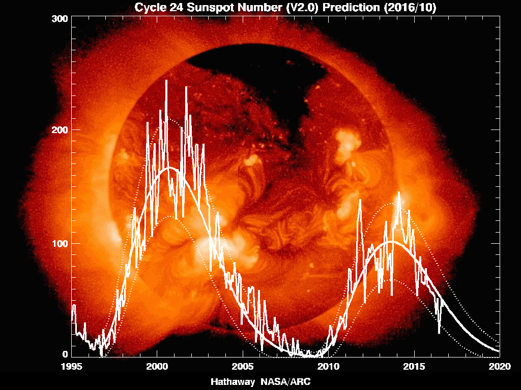
Solar Cycle – Sunspot Count (SC24)El Nino Southern Oscillation (ENSO)Quasi – Biennial Oscillation (QBO)Atlantic Sea Surface Temperatures (SSTs)Arctic Ozone Transport – Brewer Dobson Circulation (BDC)Arctic Sea IceTeleconnections – Arctic Oscillation (AO) / North Atlantic Oscillation (NAO)Global Wind Oscillation (GWO)Madden Julian Oscillation (MJO)Eurasian Snow Cover VariabilitySudden Stratospheric Warming (SSW)Then our usual suspects...The Russian High - certain to create absolute crayola output at some point, with even the ECM not immune from it's charmsPolar Vortex Location - and more importantly the fragments of vortex ( roguee Atlantic fragment last Winter threw the Met Office).The Greenland Jet Shredder - one for the nail biting frame by frame runs and the odd ms-2 stuffing things up.The Bartlett - or the Pseudo Bartlett what ever that was !The Scandi High - friend or foe - will it put up and stay up.The Beast from the East - can it emulate it's Kaiser Soze feat of tricking 40 /52 ensemble members again.Scupperers - can appear from anywhere at anytime without any valid reason or explanation.Mind Boggling !-
5
-
-
Atlantic is a real slow burner this year.
Some interest in this topographically challenged system, a 30% chance then a 50:50 into day 5 of reaching Tropical Cyclone Status.
-
I vote for Lorenzo to take over Glacier Points crown for the winter. What do others think ?
Thanks Cleve Hill for the sentiment, if I ever get near where GPs ability with the atmosphere I well let you know. Way too much respect for Stewart to begin to even think about filling those shoes, not withstanding my brain only holds about 5% of the knowledge his does... There are many few posters on here who can work up Winter a whole lot better than I. Would really recommend the Strat. thread for Winter if you want something to get your head into.
CFS and Matt throwing it into the mix with the ECM is an interesting one. The ECM seasonal if I recall correctly was a bit of a wildcard throughout last Autumn / Winter whereas the monthly ones did really well, wonder how much of that blocking signal is derived from the anomalous Greenland SSts ? Maybe a CFS blocking watch thread is in order !
-
5
-
-
- Popular Post
- Popular Post
ECM mean at 192 from meteociel.
Bit of a transition chart...looks so , so vague, hints of hanging onto summer....
and yet the op run hold onto the lower angular momentum and the crucial HP cells over Asia. The MJO vacating the Maritimes and associated upper level OLR delayed.
Interesting model watching indeed. GFS, GEFS, ECM with an active MJO or soon to be more active MJO will lead to good model disagreement within 5-7 days. Dissipating caps exiting West Africa will lead to increased tropics invest action, therefore the model split at 96 -144 hrs across will be a good watch. ECM we know builds in climatology from the MJO waves after 144. GFS really for me is an unknown although verification has improved strongly over the last 3 months.
It may be a case of reviewing classic September Buchan Singularities. it is a very late hurricane season with an MJO and GWO cycle almost starting from scratch. Outcome 4 weeks of superb model watching and analogs almost clean out of the window bar sun cycles, and with these actual sun spot reads versus the max/min may be the way to go.
Odds on no SSW to influence winter. SSTs are going to be interesting for October due to late tropics.
Atmosphere echoing shredding of systems and trough disruption over Iceland versus the prior NW/SE tilt via the greenland tip divergence, will this be a pattern for the next 6 months as we descend into winter.
Just some thoughts once I eventually get a hang of GWO ( possibly never now GP aint here ! ) will put some more up... Interesting season awaits... that echo of trough disruption beyond Greenland a real point of interest though this early prior to Winter kicking in...
-
10
-
Think my prediction about the atmosphere not kicking on until there was a Hurricane from a couple of weeks back is carrying some weight now.
A couple of invest in the Atlantic , one with a chance of a tropical depression status in 6 days marries up well with the MJO pulling out of dormancy and the extra tropics being owned by weak Kelvin wave action.
MJO kicking through the maritimes is like an ignition paper for upper level divergence, a cheeky wheelspin of African equatorial waves which will ignite tropical season, the following pacific action killing the wave 3 anchor across the hemispher and heralding a more mobile pattern. It's weird writing on the forum where winter north south divide is so very different from summer. The south hanging onto some good ridging and reasonable uppers.
One major standout from the dogs breakfast ECM of the scrambled Scandi high for +144 next week is the Greenland Tip.
There is a wee hint that what caused the trough disruption of winters past is a good 300 miles further east this year. If this is so and the atmosphere want to ghost this synoptic, without Stratospheric influence, whereby this year is a weak analog, then we are looking at a strongly mobile winter.
Caveat is that this is just an early autumn read on seeing the trough disruption in FI, and for a good idea ahead we need to see the atmosphere base pattern ( strongly a drop in trough right now ) and shredding of systems... AFTER this MJO phase.. So November 05 12 GWO and MJO will be predictor of winter 13 -14, anything before that has some mighty guesswork. This year a late read, odds on no SSW influence, Brewer Dobson annihalated in summer , ozone transport delayed. at a guess now late feb / march again. with a zonal winter. until the 05th week November cannot tell
Rant over !
-
4
-
-
Definitely pattern changes afoot, the scrambled warped scandi high on the latest ECM run tells a tale of transition. Autumn firmly on the way and you get the feeling it is in the mood to dispatch summer quite quickly.
Certainly the coolest and freshest its been for a while this evening, decent daylight ebbing away.
Hurricane season has a couple of invests plotted for Atlantic now, also MJO vacating the Maritimes, both indicative of a 'stuck ' pattern becoming more mobile.
Looking forward to Autumn now as we did get something of a summer, also be nice to track in a good old fashioned dartboard low .
-
1
-
-
Amazing video of noctilucent cloud and Aurora on beeb Scotland page, worth a watch.
Possibly the best NLC show to be recorded this summer.
-
4
-
-
So a warm up of sorts is pretty much decided on, the longevity seems to be the key issue awaiting resolve.
The ensembles are an interesting look this morning, some healthy variance around the UK in 850 temps. GFS operational on the warm side initially. First chart is the 850s, had a chuckle when I saw the 15% chance of snow for August 31st ! Although it looks like there is something altogether wrong with the chart at this time frame.
Next up the pressure ensembles, which resemble an attempt by someone who has had too much coffee getting set loose on an etch a sketch.
Is GFS 06z continuing with a warm outlier on it's operational run here. Definitely a divide across the UK evident here with upper temps.
06z has a fearsome reputation for being total cannon fodder however here at day 5 it is holding up well against the other 3 runs of this model, have they been tweaking GFS over summer due to the stunning fall off in reliability earlier in the year.
Latest 72 hr Jet pattern from UKMO interesting that that energy currently over America is dissipated. GWO phase 2 forecast, composite here.
Looks like either a nice warm up and/or some great storm potential, good chart watching either way.
-
7
-
-
Helluva double save from the new goalie. Sky Sports is free today showing on Sky 2 channel if anyone likes the Fitbaw.
-
Hello,
Sorry if I'm posting this request in the wrong thread?
Posters often put up the monthly NH composites for MJO phases here. My link for these now goes to "American Weather"
As anyone got a new link for these monthly phase composites please?
Thanks
Hello Len,
The composites are still available for free whilst other model information on American Wx has been pay walled.
-
I have to pick you up on this L; over 3 years I have never seen more than a couple of, at that doubtful instances, when the NOAA 500mb anomaly ouput showed a difference that could be attributed to the factor you quote. I did have correspondence with NOAA about 4 years ago. Their answer was that the lack of forecast input was in the technical summary rather than the actual NOAA 6-10 and 8-14 chart outputs. If I get a chance I may send another e mail and ask if in their view the NOAA 6-10 and 8-14 over weekends and BH's show any differences other than the obvious day to day differences one sees throughout the runs?
Happy to be picked up on this as elevates the subject and I know it is a topic that keeps on coming back in Model discussion, what I was meaning regarding the 6-10 day and 8-14 day upper air tools is that the prognostic discussion is not written over the weekend. I find this part of the guidance useful as it explains the thoughts of how they blend the solutions on offer and gives some insight into where a model is off kilter, too quick or showing an anomaly. Also the rating of the general outlook in terms of agreement with the score out of 5 weighting is a good indicator of the expected pattern. Not in dispute at all about the charts.
The links I have that do update over a Saturday and Sunday are these ones -
WPC Discussions and within that front page the extended analysis
-
1
-


Atlantic Storms 2013
in Storms & Severe Weather
Posted
Meteocentre plot not too far off your thoughts there John, like the link to the NDBC site, had to find a link for converting from inches ! Never knew buoys recorded the data like that, you learn something every day on Net Wx
Latest from meteo page below.
Looking at the Sat Imagery gives a good run through of how its gone the las 12 hrs. http://www.yr.no/satellitt/europa_animasjon.html
Eumetsat page with the 00z data shows the cold red airmass on its way.. http://www.eumetrain.org/eport/euro_00.php?width=1366&height=768&date=2013091500®ion=euro
Breezy, constant rain winds moderate at times, enough to give the foliage a good shake..