


lorenzo
-
Posts
4,875 -
Joined
-
Last visited
-
Days Won
25
Content Type
Forums
Blogs
Gallery
Events
Learn About Weather and Meteorology
Community guides
Posts posted by lorenzo
-
-
?? It does. Low centered 12z Mon approx just S of Hants. PPN tallies troubling across S England irrespective of windfields.
The material we can access plots every 24 hours, the point here is about the chart between the jump from 120 - 144 not being available to view from the 12z run, this leaves some blanks to fill in so to speak.
One way round this, and granted it is not from the same run is to look at the 00z for the time frame required, as per below.

-
 1
1
-
-
The 00z ECM Ensembles are worth a look, would be nice if these were slightly easier on the eye to look through.
144 / 156
A fair few troublesome solutions in the 156hr run, so not without support from the ECM either.
-
3
-
-
so IF (however unlikely) that came off, what sort of wind speed and gusts would we be looking at?
50-70 mph wind and 60-80 mph gusts. Massive caveat being as others have mentioned the GFS tendency to ramp up features like this, truth is we won't know until nearer the time if the system will bomb as projected on the 06z run. Certainly providing some good model watching at present though !
-
5
-
-
What's notable is how cool the Arctic ocean is in comparison to other years. Data issue?
Am not the best person to ask, am sure that Recretos discussed the lack of data for this region in one of his excellent posts in this seasons Stratosphere thread. Might be worth a look there.
-
1
-
-
From the 01st October and 22nd October.
Lifted from this Index. ftp://140.90.213.161/autosnow/4kmNH/
As Yarmy points out, thereby the days before.
-
1
-
-
After some tropical overnight temps, it has finally stopped raining and the yellow orb thing is attempting to put in an appearance.
Balmy October weather and steady downpours late into the evening last night.
Eventually clearing..
-
2
-
-
Quick Gif for October with the 60 line denoted.
http://gifmaker.me/PlayFrameAnimation.php?folder=2013102207xXFZ1V7rMLGlDkBoNN2Pgl
Along with monitoring this and the OPI - October Pattern Index, certainly adds another dimension to watching the season unfold to determine how much truth is in the theory..
-
5
-
-
- Popular Post
With respect to SSTA's around Greenland, had a quick trawl on Weatherbell for these maps for folk to nosey through and compare. Initial glance for this year echoes 2006, but you could argue for a couple of the other years too.
2010 the monster exception and just astounding, of course led to the black hole anomaly charts and also the excellent NASA article on Blocking.
Again, it would seem we are already on the search for the Holy Grail Greenland Block, including this image as there are many newer folks on this thread and this visual explains clearly the influence. Fact remains this was a massive exception and expectations/ comparisons continue to be based around this year which of course makes things altogether more complicated.
2006 / 2007 / 2008
2009 / 2010 / 2011
2012 / 2013
-
10
-
This is a good link http://rammb.cira.colostate.edu/wmovl/vrl/tutorials/satmanu-eumetsat/satmanu/cms/racy/index.htm
Edit - posted before finished typing, gives good information on cyclogenesis of these tye of events. Also wiki. has good links on European windstorms tracking the notable ones.
This site uses real time imagery and the latest model run in overlay and provides amazing imagery for these type of storms.
http://eumetrain.org/eport/euro_06.php?width=1366&height=768&date=2012122906®ion=euro
-
2
-
-
well wort a read folks; it gives a good idea of how they feel they are doing and also just how complex this area of forecasting is
I liked this quote towards the end as it highlights we are into a new ballpark so to speak with respect to how Winter has behaved over the last 20 years or so. Cohen's study took things back to probabilistic forecasting, it would seem that the dynamical models whilst capturing for example the prediction for ENSO well, are less useful elsewhere.
Much more probabilistic slant, highlighting the full range of possible solutions, placing these in the context of climatology, and in particular in the context of the recent past.Also that 'Drivers of Predictability' screen used in conjunction with ECMWF is brilliant.-
1
-
-
Thanks Lorenzo, no need to rake over the whole thing again but I support the points made by SM at the time.
Not raking Ian, just directing others towards the explanation given to provide some context. It was a helluva debate at the time.
-
If anyone wants a detailed explanation regarding this debate look here. A little superficial to just say it was the Pacific Jet when this explanation details more clearly the broader pattern.
-
Half ( Perhaps all...) of Scottish Regional Thread want extreme weather emergency !!! There are some B - Bag type charts on tonights GFS Run,
ECM being rather more sensible about things at present..Will be an interesting countdown to Halloween..-
3
-
-
ECM a much calmer solution than the rampant GFS 12z.
GEM explosive again, also noticed it's tendency to crank up Lows with continued regularity, jet profile below.
ECM ensemble map will be worth a look this evening to see how many clusters are in there.
-
4
-
-
Here is another useful link on Waves. Thanks to Nick Sussex for this from last Winter, when everyone was debating about shortwaves, wouldn't be Winter without a shortwave drama.
-
1
-
-
October determined to go out with some ferocity on the GFS 12z which someone seems to have poured a can of Red Bull in at initiation.
Vicious looking low appearing across the ensembles, even the mean would be more active than what we are used to at present.
Mean
Wild jet profile also visible in the suite. For example this 300km/h rocket.
UKMO looking poised also, over to the ECM to see what it makes of things..
-
9
-
-
Fantastic post forecaster, very useful explanation that will be of benefit to many.
-
1
-
-
Evening All - still drookit, particularly earlier this evening when it reached drooned rat status.
A little milder now and a fine moon.
October not the same as always with no frosts. Perhaps we will pay for that much later in Winter too....
-
4
-
-
Great link - had good fun playing around on that site !
Sunday image courtesy of post on amwx.
-
The meeting was very good, a clear and concise presentation on the MJO, spilt into 2 sections.
First was the history of how Madden & Julian first discovered the MJO, the cycle, the impact across the tropics, essentially explaining what the MJO is and what it does.
Second half focused on the impact to the North Hemisphere and cited the Cassou paper published in Nature in 2008, before going on to discuss the issues within the ECMWF model resolving the MJO activity, tracking from 2005 to date model improvements including the recent improvements to how it views convection.
I hope to obtain a copy of the presentation so I can add it here. Will let you know as soon as I get an update. Having watched the MJO impact over winter for a few years now I was generally taken aback by how little known this cycle is among the general audience at the meeting.
-
1
-
-
- Popular Post
- Popular Post
Atlantic washing machine inbound....
Pity, as everything looked glorious out West to start the day.
Forecast - Drookit, looks like Fife gets the bulk of the rainfall sustained from around 1600 - 2100.
-
11
-
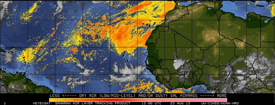
Interesting read. Much research has to be done to help getting a better understanding of this possible multidecadal cycle.
Another interesting article discussing the same subject is from a blog on weather underground.
The article states that there might be a link between low RH's in the Main Development Region and low RH's in the Southern Hemisphere (mainly in the South Atlantic). I don't know if this is well-known science or new, but it would be interesting to find out wheather the link between the low RH's has anything to do with the possible cycle of dust coming from Africa.
I'm new here, so please accept the possible bad grammar!
Welcome along to the forum Vorticity and thanks for the link, great satellite loop included in that story.
https://www.e-education.psu.edu/worldofweather/files/worldofweather/SAL-6hrs-Aug23Sep05.gif
Don't worry about grammar at all - hope you find plenty here to keep you occupied.
If you can add your location to your profile, something we usually ask new folks to do that would be great.
-
Great Result for Scotland V Croatia. (will just ignore the fact it was a meaningless fixture..) Team have definitely moved forward.
Nice find Cheggers, amazing pic. Hopefully Comet ISON survives it's sun grazing and produces a great show for Winter, ISS also on a very bright pass tonight.
Feeling much colder this evening under clear skies. MJO lecture was informative and hopefully will get sent a copy to share on here, not too much insight into Winter 13/14 though, more along the lines of this is what we can see it does in European Winter and also looking at how they are trying to improve it's representation within the ECM model.
Atlantic gearing up to the 'actually being there' phase versus completely dormant. Should provide some interest via good radar and satellite watching. Nothing as spectacular as this thankfully though.. Typhoon Wipha.
Oshima has received 22.7 Inches of rain http://www.accuweather.com/en/weather-news/typhoon-wipha-aims-to-batter-t/18839653
Edit - Ian Fergusson â€@fergieweather
"@metofficestorms: Typhoon #Wipha drenching southern Japan. 788mm (31") rain in the last 18 hours on Oshima island south of Tokyo."
Back home Loch Morlich looking bonny but very eery today from this Pic on the Fbook page.
-
6
-
-
Interesting article in relation to dust and the impact on the storm season, relates back to early 80s dry period and hints at another atmospheric cycle being present, which as yet is not understood.
http://www.sun-sentinel.com/news/broward/fl-african-dust-outbreaks-20131014,0,1753512.story


Stratosphere Temperature Watch 2013/2014
in Spring Weather Discussion
Posted
Solar influences on the stratosphere are well researched. Dr Karin Labitzke is the key author on the subject at the Free University of Berlin. Resume Brief here
There are many papers newer than this, however this is a good one to have a flick through.
ftp://geosp-server.aquila.infn.it/isss/ASSE06/Labitzke.pdf
With respect to the impact of solar activity on the precise location of the Polar Vortex with respect to increased solar flux, not something I have seen studied in a paper yet.