


lorenzo
-
Posts
4,875 -
Joined
-
Last visited
-
Days Won
25
Content Type
Forums
Blogs
Gallery
Events
Learn About Weather and Meteorology
Community guides
Posts posted by lorenzo
-
-
The zonal wind profile on Berlin site shows the GWO impact well. Had to double check the year at day 5 or so it looks like an easterly QBO.

That wave 2 plot is a great watch upwelling then completely across the grid.
Heights
-
 6
6
-
-
Cold dry sunny day here frost lay all day in very shaded areas currently 1c clear with a grass frost.
Going to see Aurora Storm on Tuesday in Edinburgh and was going to try and take in this ; http://www.rmets.org/events/forthcoming-meetings. Anyone else going?
Managed to get along to last months meeting, can't make this one unfortunately, work calls, off to Manchester to attend an awards gig, managed to somehow convince someone that I actually work when at the office. Cannae turn down a free bar and free evening meal, plus an overnight in a hotel, with no hungry baby waking you up at silly o'clock !
Hopefully you all get to meet up, great idea, if it doesn't happen this time, we should arrange a date for all fellow Kilters to meet up and have a few ales and a blether.
-
6
-
-
CFS or GFS !!
12z going off on one...
All day pub session from the GFS today, rather than waiting til the evening.
-
8
-
-
I think it's unlikely (I know I'm not Lorenzo
) as we have a pretty standard warm front, so we'll see a good 2-3 hours where the upper air temperatures rise and cloud cover enchroaches before we see anything falling out of the sky. Take midnight for example - uppers already above 0C for most of the country:Just to save Buried any confusion, am not Lorenzo either..
Totally agree with LSorenzos post above, flipping from the Winter Side of November back to the Autumnal. Rain Today already loaded over Ireland..
-
3
-
-
Beautiful clear crisp winters day. Oot the sun freezing, but nice in the sun.
Lorenzo if you want skating, my deck oot back is very slick with ice still holding firm.
Much the same here Cheggers, took a wander out to the local shop around 8pm last night and nearly fell on my airse a few times.
Not got a weather station of any kind, but it was cold enough to freeze the wheely bin lid shut, which I guess is -2 / -3 overnight.
Still looks frosty out there, Atlantic action inbound.
http://meteocentre.com/sat/get_sat.php?map=_vis&anim=1&area=uk〈=en
From the Hi Res Satellite, snow cover extent on the mountains looking amazing.
Here's another site to play around with Meteogram comparisons.
http://meteocentre.com/models/get_mgram.php?stn=Aberdeen&mod=compar&run=12&var=std〈=en&map=UK
-
5
-
-
Not sure Buried, good question, Need Chiono to provide a clearer answer than one I can, still find the whole definition of them pretty vague to say the least..Canadian Warmings often happen in early winter. They take place when the Aleutian stratospheric high intensifies and moves poleward. The Canadian warmings can reverse the meridional temperature gradient and sometimes briefly change the zonal wind direction over the polar cap, but nevertheless they do not lead to a breakdown of the cyclonic polar vortex.Still the whole puzzle around these events is of interest and here are some some analogs of Canadian warming years to try and get a clearer idea.A Sunday puzzle to work through these and make some deductions...10mb / 30mb / 50mb - November Canadian Warming Years
10mb / 30mb / 50mb - October Canadian Warming Years
10mb / 30mb / 50mb - October 2013
October 500mb Analog vs October 2013
-
6
-
-
- Popular Post
- Popular Post
Another precarious winter countdown begins.. hard frost up here this morning, feeling like Winter already,look forward to when everyone else can join the fun.
ECM @ Day 10
ECM vs GFS, GFS much sharper.
GFS
GEM - really ramps that low and provides that west based solution.
GEFS for same time frame
Maybe am getting chart fatigue, I always thought the 12z runs were more bullish for cold solutions, seems the 00z is the new 12z !
-
10
-
JJ Frost has been on the rampage overnight, feeling like proper Winter oot there this morning. Didn't quite make it to the 3am Ice skating session though.
Charts to match too !
GFS determined to deliver a Greenland high, will it still be the same at 12z....?? Mixed solutions across this theme from GEFS, GEM and the ECM out at day 10, so plenty of model watching between now and the 20th to see how the strength of this ridging and warm air advection turns out.
-
3
-
-
- Popular Post
- Popular Post
Some quality model output around for cold lovers this morning, just added a bunch of charts to the model thread. Here are the best ones..
ECM wanting to slam Scotland into the freezer after mid month..
Go on verify ECM, you know you want to... this one will jog a few memories..-
10
-
- Popular Post
- Popular Post
I dont know enough about Canadian warmings yet... but it is a small straw I still have a finger in contact with. I have asked Chio about it over on the Strat thread but he seems to have gone very quiet. That isnt a great thing in itself because when he senses a warming, or reads one coming, he tends to post quite frequently. His silence to me is deafening.
CH, Canadian warming events are very rare, whilst one is overdue they are a bit of an anomaly in themselves and cannot be really categorised until after the fact with re-analysis. Last one 13 yrs ago ! Evn without the CW there is plenty of other interest.
Here are a few of the latest TC's for PNA / AO / NAO, the positive regimes of the AO and NAO heading toward a more neutral > negative position.
With the PNA being an upstream pattern that is not often referred to on here, this image neatly shows how the hemispheric pattern is set up. The ECM earlier this week very bullish about the cold plunge but has backed off a little.
Onto the ECM which is pretty amazing looking and let's hope it maintains the theme.. 144 is a point of interest as this is where that MA ridge really cranks up.
Then some fantastic cold looking charts thereafter.
Great to see, will we have a game of ECM picks up a trend, drops it, GFS picks up the trend, drops it, then both verify and annoy the hell out of everyone with GFS getting the blame..
-
31
-
Could anybody help me please?, there was a post on here last year listing the date and type of every SSW since strat monitoring began, I was wondering if someone would be kind enough to post it again please. Thanks in advance.
Could anybody help me please?, there was a post on here last year listing the date and type of every SSW since strat monitoring began, I was wondering if someone would be kind enough to post it again please. Thanks in advance.
Aside from the Berlin page, here are another couple of frequently used lists of SSW, one matching to ENSO and the other displays displacement and splits.
Couple of charts from this morning GFS 00z, peak of warming activity at 30 mb by 72 hrs before this subsides.
Out to t+192 at 10mb a very Cold looking compact vortex approaching -80 degrees, with 2 distinctive areas of vorticity.
-
7
-
-
Further footage from Tacloban City.
Debris visible and wind audible.
http://instagram.com/p/gboELfKWyn/
Really not looking forward to seeing the human side of this as opposed to the pure meteorology in the build up to landfall.
-
4
-
-
Strongest Landfalling storm in World History.
http://www.wunderground.com/blog/JeffMasters/comment.html?entrynum=2573
-
-
9
-
-
Sunrise beginning now. Going to be some unreal imagery and footage of this monster.
Video from Tacloban City http://instagram.com/p/gbfcM6KW1x/
Unconfirmed that Satellite reports of 858mb...
-
1
-
-
Congrats Edo ! No idea how you will find the time with 4 of them on the go, I struggle to keep track with 3. It's great having a boy though to even out all the Girly stuff !
From further afield on Netwx, thought I would share this from the Super Typhoon thread, a totally stunning image of Haiyan / Yolanda.
Frightening.
-
6
-
-
Some crazy imagery on Twitter right now.
This loop is spell binding a real jaw dropper.
http://cimss.ssec.wisc.edu/goes/blog/wp-content/uploads/2013/11/131107_coms1_ir_haiyan_anim.gif
-
7
-
-
- Popular Post
- Popular Post
The type of blocking over the nh can take on many shapes and forms, we can get a scandi block in a predominently zonal flow we can a GH in a cold stratosphere - Remember we can get cold with a neutral AO as well..I homestly think people put to much faith into the strat thread, its great to use as a guide and even more exciting when there is some explosive warming however that usually spans just a short period of our winter time-The strat is only just beginning to be discovered, we are only at the tip of the iceberg in terms of its interactions, what we do know is the larger the +ve anomalies do in terms of polar heights, but we would would be better off reanalising what the height profiles were like in the 'normal' periods not just the execptions.Im sure the strat thread will be busy this winter - however the bottom line is though because the models will model any such warmings they will be onto it before any forecaster on here as we simply dont have the full picture to beat them to it....S
Steve,
I get what you are trying to say, the strat thread is popular and people take what they want from it in a linear fashion. i.e Raging Vortex - no Cold. Broken Vortex - Easterlies galore. In reality it is trickier than that and not a guaranteed route to cold. You are right to say it is a guide, but I don't think we rely on the strat alone. This winter the GWO and ENSO are arguably more interesting as trying to understand and fill the void in information left since GP departed.
Some images below that confirm the research being done regarding loading patterns for SSW events, which means we can look for these patterns in the model output and look ahead to attempt to predict the evolution of the strat, of course reliant on model information.
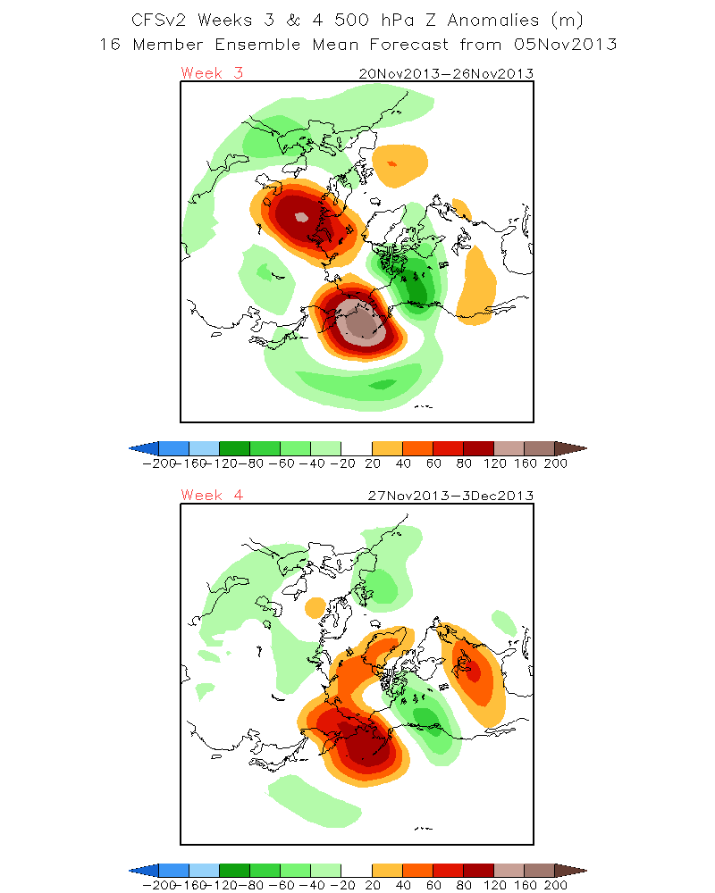
Meanwhile, the CFS view of the blocking for week 3 and week 4, teasing output into December.
-
18
-
Very cold start to the day with a strong SW wind and a temperature of 2.8c making the old farmhouse feel decidedly chilly. Cows and calves shifted for last time into south facing field before coming in in 10 days so winter is properly here.
I trust NL better than the GFS
for the Winter is here..The Pacific Rim is struggling away to amplify sufficiently to make inroads in the Arctic. The peak around +72 hrs for the wave activity created from the Kaijus.
Week 3 and 4 CFS shows the mid Atlantic ridging, then some high latitude blocking into December.
http://origin.cpc.ncep.noaa.gov/products/people/sweaver/cfs_fcst/images1/wk3.wk4_20131105.z500.gif
Overall a positive AO outlook, but this isn't hard and fast for Winter. The AO after peaking is trending negative for a period, and the NAO weakly negative, so some blocking across either Greenland > Scandi > Russia potentially on the cards.
-
6
-
-
An overall positive trending AO for winter has in previous winters also included periods of negative AO.
So all is certainly not lost. That said we could do with an SSW again this/early next year after a period of staring at a rampant vortex.
-
2
-
-
OPI is October Pattern Index devised by some Italian Meteorologists, it is an extension of the SAI work by Cohen and claims high correlation with the predicted winter AO.
Link is here.
http://www.centrometeotoscana.it/forum/index.php?topic=7473.0
Correlation
Interesting reading
-
1
-
-
Right, will leave this ugly looking analog here, based in particular on the OPI and predicted AO and ENSO neutral range depicted on plot. Here is your DJF analog for all dates. Quite a limited dataset.
-
Yesterday it was the crystal clear skies, today it is the hazy sunshine through the low Autumn fog.
Lovely crisp morning and also enjoyed scraping the car !
Enjoy fireworks night.
Got to love Scotland...
http://www.youtube.com/watch?v=sSJ5PgUx0Zg
-
7
-
-
Great analysis by Ethan in that blog post, from the Mitchell presentation on the publications page, see link in Teleconnection paper thread by Interitus. This chart has a longer term look at the trend.
January is the month to watch..
Edit - correcting typo.
-
2
-


 ) as we have a pretty standard warm front, so we'll see a good 2-3 hours where the upper air temperatures rise and cloud cover enchroaches before we see anything falling out of the sky. Take midnight for example - uppers already above 0C for most of the country:


 for the Winter is here..


Stratosphere Temperature Watch 2013/2014
in Spring Weather Discussion
Posted
This page is also excellent within the Roundy pages, bit of a technical challenge to read !
Directory of MJO HovMoller plots - http://www.atmos.albany.edu/facstaff/roundy/waves/hovsdetmjo/
Current equatorial Plot - http://www.atmos.albany.edu/facstaff/roundy/waves/hovsdetmjo/0_7.5N/2013.png