


Snowmad79
-
Posts
1,102 -
Joined
-
Last visited
Content Type
Forums
Blogs
Gallery
Events
Learn About Weather and Meteorology
Community guides
Posts posted by Snowmad79
-
-
Well i can see some nice ppn over the hills to the north of Rochdale but broken cloud above me and not a single flake ... oh wait I see a couple passing the window now

Rochdale is about to dissapear from my view by the looks of the snow showers up there.
-
Update - PPN TYPE radar including wind direction, speed and importantly T850 temps :
Just to add Dew points are generally -1 to -2 in the region.
-
hey mate, what time do you expect it to arrive here?still got plenty up there?
Alright mate,Yep pretty much the same covering since monday with the odd little thawed out patch. mainly the paths and roads but not too bad really.
As for this precip the some patchy showers should be hitting the coasts around the southport area about now for us inland it depends becuase again the radar is showing well,errm not much of anything heading our atm. Keeps showing a mighty gap in precip heading our way then re-intesifying it lol.
Too hard to say when we get it atm but a couple of ours i would think. .. thats providing the ppn reapears on the radar :lol:
-
Hi Guys....
I'm new to this forum...whats the chance of snow in the windermere area...because we never get any....
...ha.ha...!Yeah its looking ok for your area atm and those north of say Preston.
The bad news for me is the huge gap appearing in the front which is heading my way
.On second thoughts the radar shows ppn has now intensified in that gap lol. This is a nightmare to follow.
-
Look at northern ireland and northern wales / angelsy cams on this link (by clicking the dots on the map) : Uk&Ireland Cams
nothing happening in these areas lol the ppn should be over them :o
-
I only have the radar package..i just use the free gfs with the radar kind works out nice really. it does look like a load of snow out there in the irish sea, though nowhere near as intense as it was coming out of ireland but thats to be expected i guess but id like to see that bigger darker band to head further south than it currently is. I agree deffo with the se potential especially as it hits the wind from the north. Latest beeb forecast has the snow lasting in the region until around 11pm, with the more heavier snow from about 3-11pm, the good thing is we'll still cop this stuff from the irish sea well before then, even if its only light with the amount out there it could produce quite a covering..though i saw a few glitches with the radar before, so i doubt the defragmentation is that bad lol
Sounds good mate, it maybe could still be similar to mondays amount .. well not including the drifts, back then the snow wasnt big flakes or that heavy just fine stuff mainly and it was just the persistance of it that caused most of the accumilations. So heres hoping for a long period of snow showers
-
yeps and also a shame it spilt up during the night. Problem now is whether we are going to see a warm sector of air ahead of that main snowband heading west. slight temp climb here dew has gone up from -3C to -2C but then previously it fell back to -3C, my other concern is the temp..beeb say max is 2 and predominately heavy snow for liverpool and region..I am not so sure. mind you we have up air at -8C so it might not be so bad afterall
Just bought the netweather full package (which id reccomend coz the amount of options are mind boggling) for a month and after a quick look .. the precip type radar shows the actuall snow to be slightly better than rainfall image the only sleet and rain appear to be on its far southern/ back edge atm. not only that as this fronts hits the uk it looks as though it will start back on SE track due to the wind factors coming down from the north. so it could be quite prolonged.
Cumbria area might get the heaviest out of it too ( along with southern scotland) which the GFS was suggesting the past couple of days.
-
Lastest NW radar image for 09:15 :
Shame those notherly winds wernt stronger, im sure they would have help to slow the front down even futher.
-
well that front certainly slow down alot over ireland and its nice to see its actually shifted direction and looks to be intensifying as it heads towards and over the irish sea.
all I can say is Phewww thank god its lookinh better now. Theres also talk the Meto have put the channel low futher north, that ascociated band of ppn was due to hit the south of our area across the pennines into yorskshire on the most northerly placed runs .. so we cant rule out the possibillity for tuesday. What do ya think ?
-
I fear you might be right.
Sorry guys but if we miss out again - I mean - you could'nt script it could you?
Seems like the norm for our area. We only get "lucky" these days with regards to snow.
Typical though isnt it .. when its mild mushy weather u can 99.9% garuntee we end up with the best of it here in the "artic northwest" lol
-
This is looking like going pear shaped for us. That band is moving increasingly southwards as it approaches......
-
whats the crack in Ireland atm then ? the radar is lookin good for you now.. it rain or snow ?
-
Was most definately blizzard conditions up here last monday , high winds , driving snow and obviuosly the other problem was snow that was setting being blow up in wind too leading to decent drifting. Classic baleclava and goggle weather to be honest.
Can't beleive its coming up to 7 days since our last decent snowfall in the NW. Seems like an age ago even though we still have a decent amount of laying snow and drifts.
-
I shouldn't think so looking at the sat pics, it's just most is still out of the radar coverage. http://www.sat24.com/Region.aspx?country=g...r&type=loop
You might be right looking at the water vapour satallite images from noaa the bulk of it is or i hope is pretty much behind the initial frontal cloud and showers hitting ireland now:
http://www.ssd.noaa.gov/eumet/neatl/wv-l.jpg
More images here to look at :
-
well its looks to me as if that band has been moving too far / fast SE and I reakon it could miss us all together.
-
http://raintoday.co.uk/ there also on the meto rdar over western ireland .
-
hope those shwers on radar arnt the ones meant to come our way, theyll be dead by the time they get here or way too south.
-
http://images.netweather.tv/monthly_02_200...-1234025309.png
Get ready for rain southerners
LMAO!
Remember peeps BE PREPARED, we dont wanna here about you people being rescued from floods for the next 5 days
-
:o :o :o :o
Blizzards, snow storm of the century for Yorkshire!
I guess we'll be talking YETImetres in the near future then hey ? :o .
No seriously that band is progged to hit us too here in the northwest.. im just worried about the Surface condition charts, dewpoints and the T850s etc that accompany this band of precip due the warm sector being futher north, have you checked them ? what do you think mate ? . back edge snow does look possible as the band stalls, swing round and heads SE but nothing special in my eyes
-
Looks like a bit of an upgrade for us on the 12z for tomorrow, not so much the intensity but defontly a better track of ppn through the region. It also reaches the region sooner on that chart around midday.
Theres still the problem of the dew points and t850's etc raising as the band passes through.
Also the band of heavy ppn that hits the uk with the LP passing across the south on tuesday is progged futher north and funnily enough ends up over us and appears to stall for a time before swing round and heading SE but again we have the problem of high dew points and T85o's due to the warm sector of the LP. back edge snow is possible for southern areas of the nw.
The south most probably getting a absolute soaking before the colder air catches up lol.
MMMm thats strange could see the moon already in broad daylight, not sure ive seen that before.
-
Depends wether current gfs charts or the meto forcasts verify i think, theres still alot of uncertainties even with tomorrows event. As far as next weeks weather is concered the south and south east look like getting a right good soaking before any chance of snow which I hope they do as seen as most of the precip has been going there way. Even tomorrows precip was heading for us but oh no, it weakens slighty as it passes over us then really intesifies when it heads towards the london area. Very very annoying.
We'll just have to wait and see :lol:
-
Oldham, North ?? Since when ? That's in the midlands !!
LOL i suppose that is debatable but the fact is authoraties, meto etc etc all class Oldham as the Northwest and our accents are nothing like southerners so that is good enough for me. I'm a northerner and proud mate :o
-
The met ofice have changed their forecast from heavy snow for tomorrow for me to light rain and a bit of sleet. Not sure what has prompted this.
My god that damned 06z GFS has ripped my last post to shreds in one foul swoop. Precip is weaker on that chart and yeah the ppn is again coming in with warm air. then as it reaches the london area it gains intesity. The only conselation for me is that those darn sarf are gonna get a huge soaking if the latest charts verify.
Mind you I did say its subject to change. :o
Ill be surprised if it doesnt atleast start of as snow :o lol.
-
I know - I just seen that. Pathetic isn't it.
Blizzards here overnight, higher level routes blocked, but no, an icy pavement in England is more important. Remember, it's only us Scots.
Err can you not tarnish us northerns with the same toilet brush as those pansies down sarf thanks
.Its not just icy pavements down there either .. dont forget the CURSE of the "KILLER 3FT ICICLES" which Ironically and THANKFULLY have not killed anyone.. YET.


 ...ha.ha...!
 .
.


 :o :o :o :o
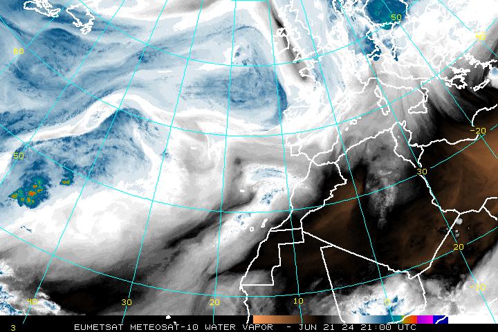
Snow Watch: North West England
in Spring Weather Discussion
Posted
Looks like it stopping here now :lol: . An excellent blink and you'll miss shower lol