


Jeremy Shockey
-
Posts
830 -
Joined
-
Last visited
Content Type
Forums
Blogs
Gallery
Events
Learn About Weather and Meteorology
Community guides
Posts posted by Jeremy Shockey
-
-
- Popular Post
- Popular Post
2 minutes ago, bluearmy said:Think it would be marg….inal
quite a spread in the ensembles
-
 13
13
-
 2
2
-
 i wonder if there will be a slight dusting on the Moors tomorrow morning in the usual spot just north of Fylingdales ?
-
3
-
-
30 minutes ago, steveinsussex said:
No chance of that happening today
big upgrade on the UKMO long range forecast 28th Nov to 7th Dec just published a few mins ago
-
4
-
3
-
-
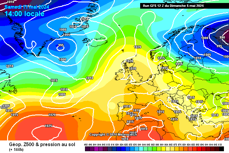
GFS 12z @ 144
ECM 12z @ 144
UKMO 12z @ 144
Overall today i think the chances for a pure "clean" Northerly have diminished slightly but the opportunity for further amplification later and a more prolonged cold snap have increased , Yes ECM has moved towards to GFS a bit. The UKMO is ironically the poorer of the 3 and may give us just a glancing blow of cold for the North and East.
Can the really cold air with -5 to -8 uppers get South early enough on 24th -25th Nov that is the question ?
A good day of model watching overall for coldies and a much better position than we were in just 1 week ago.
-
4
-
-
GFS 06z short ensembles.
That's a very good mean from 24th onwards.
It may well be that the Northerly doesn't develop this quickly or is more short lived ( eg the UKMO 0z solution ) but it seems likely that we will see at least a 48-72 hour cold spell for most of the UK in the last week on November.
I would be surprised if it doesn't topple or get shunted East fairly quickly in the end , but a very good start to the "season" with Northern Europe getting very cold early
-
9
-
-
-
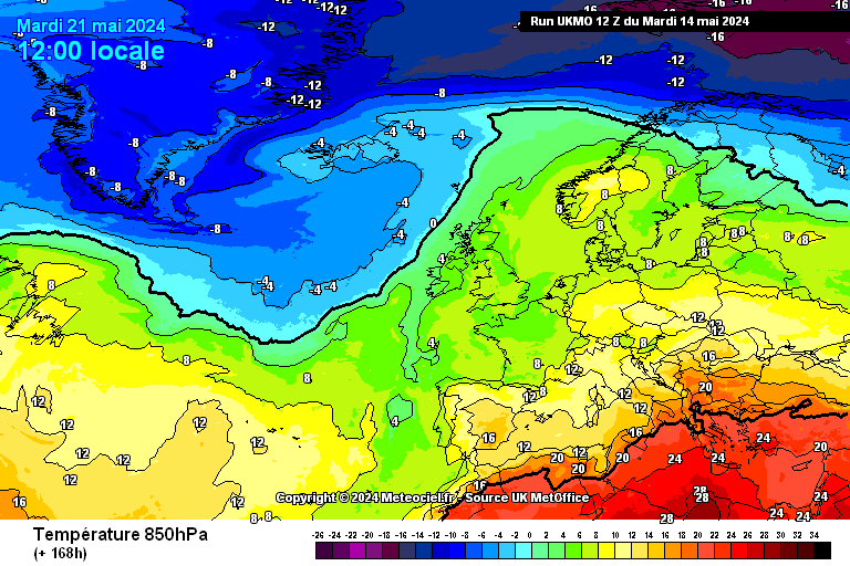
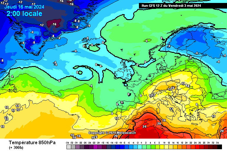
UKMO 12z 850's at 168 hrs
Whilst be have the most recent UKMO output showing these uppers at 168hrs i think we still have a decent cold chase ahead over the next few days
-
6
-
-
ECM 12z ensembles 850's
The Mean is poor but worth noting perhaps that the Op is at the very top of the ensembles from 24th to 26th. There are a good few members in the -5 range during that period in question
-
4
-
-
-
3
-
1
-
-
GFS 12z ensembles
An outstanding Op for late Nov and not a bad mean ....... unless the early evolution is wrong ( in which case it is worthless )
-
3
-
-
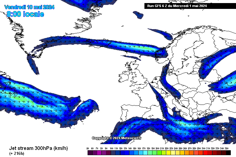
GFS 12z jet stream 25th Nov
As we head towards Winter , one feature that keeps cropping up over recent days in the model output is the favorable angle of the jet.
We may indeed get lucky at some point in the next few weeks and be pleasantly surprised with a 48-72 hour Northerly or Northwesterly that delivers for Northern hills ( Scotland ,North York moors Peaks etc and maybe higher ground in the Midlands or even the South )
Better than a raging Atlantic anyway !
i wouldn't write of 24/ 25/ 26 Nov for a cold snap in the NE of the UK just yet either
-
1
-
-
-
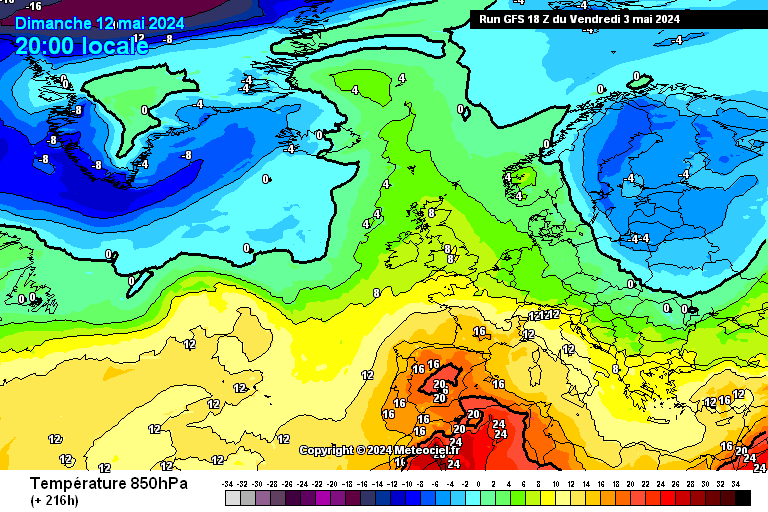
GFZ 12z 850's for Mon 27th Nov
Given where we were only a few days ago ( and with the seemingly endless dismal UKMO forecasts of wind and rain ) ......this is a very welcome development from the GFS.
Cold and frosty and maybe some snow for Northern Hills i would expect. Awaiting the ECM12z with interest,
-
5
-
-
ECM 12z ensemble mean
Not much to be gleaned from the ensemble mean at the moment but one to watch over coming days. Op a bit on its own at the end
-
3
-
-
ECM 12z at day 10
Wow ...... liking this a lot
-
4
-
-
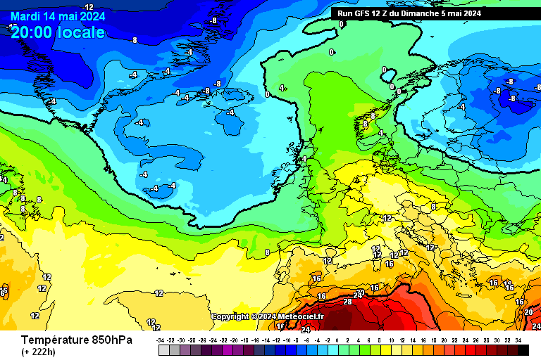
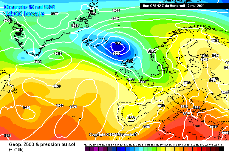
GFS 12z @ 228hrs
ECM 0z @ 240hrs
The GFS 12z @ 228 hrs has moved the high pressure towards the position of the ECM 0z @ 240hrs. Previously the center of the high was over Ireland / Cornwall. Will be very interesting to see the ECM 12z chart at 216 shortly. Not far from being an interesting set up for cold lovers
-
4
-
-
GFS 0z @ 240hrs
ECM 0Z @ 240hrs
I wonder which model ( GFS or ECM ) will have have the position of the high more correctly orientated as we count down the next few runs.
Didn't see much suggestion of this from the medium term MetO update 2 days ago. But this looks much more interesting for cold lovers !
-
1
-
-
GFS 12z for Nov 17th
850's
Some emergence of high pressure over Scandinavia trying to hold back the Atlantic onslaught , but it doesn't last long. Some cold air not far away to our East though which is good to see
-
3
-
-
- Popular Post
- Popular Post
-
-0.5°C here in East Yorkshire at 0500 hrs and an air frost. I suspect some of the good frost hollows up on the Wolds ( eg Thixendale have a good icy covering this morning )
-
2
-
-
I'm up in the North of Scotland for a long weekend.
Could get interesting on the hills.
high res WRF NMM 12z
ARPEGE 12z
regards JS
-
1
-
-
-3°C and lovely this morning-
3
-
-
Up at Givendale this morning
magical up there
-
4
-
-
Rain turned to snow here about 2 hours ago so we have a covering now and stuck in a streamer from the North East
-
4
-


 i wonder if there will be a slight dusting on the Moors tomorrow morning in the usual spot just north of Fylingdales ?


 UKMO 12z @ 144
.jpeg.a42d67293f4585a796f66cd28b4892f2.jpeg)
 UKMO 12z 850's at 168 hrs
.jpeg.141b6e9b181477e4ebaed5790120bc8c.jpeg)

.jpeg.2421e74047703c1b414bead1f5e255ff.jpeg)

 GFZ 12z 850's for Mon 27th Nov


 850's
850's
 t300 GFS0z
 high res WRF NMM 12z
 ARPEGE 12z


Yorkshire and E England regional discussion
in Yorkshire & E.England Weather Discussion
Posted