


mezzacyclone
-
Posts
769 -
Joined
-
Last visited
Content Type
Forums
Blogs
Gallery
Events
Learn About Weather and Meteorology
Community guides
Everything posted by mezzacyclone
-

From the album: bits
abc -

From the album: bits
old symbol -

Carinthian's Latest Arctic Reports Thread
mezzacyclone replied to carinthian's topic in Spring Weather Discussion
Please correct me if i`m mistaken Carinthian but upon zooming into this chart arctic atmos cryo pic hosted on NW it appears the minima has not met last years and as its the 1st SEP tomorrow surely the lowest has peaked? and the increase of those "bergy bits" Kipp is very impressive given 26HRS between the 2 shots? -

From the album: bits
arctic.atmos.uiuc.edu 31AUG 06 -
"Possible Very Severe Winter On The Way" Off we go and its only the bloomin end of August! where crying wolf has cast another coming winter to the annals of history as being relatively snowless and mild, I`d request one year that everyone would just leave it to chaos theory as it should be, then analyze the setup when it comes via the NW experts? Unless someone could provide some concrete evidence currently on hand to back-up the ridiculous topic title then lets stick to the short term weather conditions and whats on CBBC.
-
Your Peach tree is highly susceptable to cold and frost noggin and should be located indoors through winter but if your Olive tree is mature then you should have no problems as they can endure prolonged temps below -10'C, So as you mention its south facing and sheltered then it should be OK! I on the other hand have a yearly battle with these damn Musa banana varieties! wish id have a collection of very hardy Butias, chamaerops and trachycarpus palms now we appear to hopefully be back into a traditional phase of winters? An eye catching and relatively easy to care for, although not quite as hardy a plant is the Cordyline australis, Ihave 2 that are planted outside 1 in a poor soil base and they have shot up without any attention other than a simple nitrogen feed and bound with an old carpet and plastic moisture protector thru winter when sustained freezin temps are on the cards! such as the upcoming blast "SM" predicts starting next Thurs/Fri???
-
19:35, North Sheffield, 395Ft ASL Dry, Light SSE breeze, 28.8'F, 8 oktas full cld cover, 86% humidity. Previous overnight (28/12) minima 22.9'F, Daytime maxima (29/12) 30.1'F - (south facing, sheltered)
-
`bout time! seasons lowest temp 1.6'C just broken! south facing ghetto in the `burbs of sheffield anyway so maybe i`m asking too much for an air frost? Thin high cloud, V Light breeze NNW.
-
NE mallorca Can Picafort-Alcudia 06/09/05
Images added to a gallery album owned by mezzacyclone in Member's Gallery
Severe storm -
-
From the album: NE mallorca Can Picafort-Alcudia 06/09/05
4 sig -
Sheffield: Clear + dry, Light NW breeze, Already down to 35.6'C, about time this seasons record minima of 38.8'C was broken!
-

From the album: NE mallorca Can Picafort-Alcudia 06/09/05
-

From the album: NE mallorca Can Picafort-Alcudia 06/09/05
-

From the album: NE mallorca Can Picafort-Alcudia 06/09/05
-

From the album: NE mallorca Can Picafort-Alcudia 06/09/05
-

From the album: NE mallorca Can Picafort-Alcudia 06/09/05
-

From the album: NE mallorca Can Picafort-Alcudia 06/09/05
-

From the album: NE mallorca Can Picafort-Alcudia 06/09/05
-

From the album: NE mallorca Can Picafort-Alcudia 06/09/05
-

From the album: NE mallorca Can Picafort-Alcudia 06/09/05
-

From the album: NE mallorca Can Picafort-Alcudia 06/09/05
-
From the album: NE mallorca Can Picafort-Alcudia 06/09/05
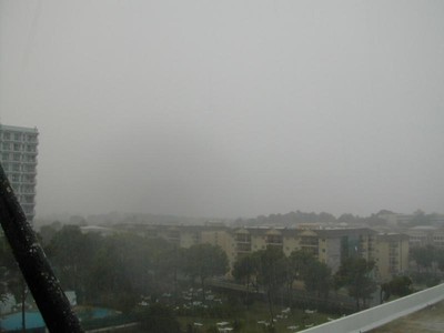
Locals said it had not rained since late May, my timing for the holiday was therefore brillaint, Saw the breakdown occur on the 4th when unusually rough winds from NE brought very choppy seas early in the morning after months of v hot and dry conditions, observed high cloud 5th with turbulent cloud over mountains and come the 6th i saw a absolutely perfect gigantic anvil high up above the whole North of the island looking westerly toward Palma around 13:00 but unfortunately was not cammed up for, To feel the atmosphere and electricity in this storm when it unloaded locally around 15:00-16:00 was like a dream, the hailstones were brussel sprout sized and a couple felt like golfballs! it was like being in a gigantic hot shower, and to feel the strength of the wind tear structural awnings down and fling lilos around was something else, I could not see clearly at all yet being drenched like never before in such warm rain was exilerating, the whole storm moving NE with the wind coming from that direction was great to see, I`m definately a novice storm chaser now and the famous "T alley" becons like never before! -
Met Office Forecast In The Telegraph
mezzacyclone replied to Michael Fishermans Friend's topic in Spring Weather Discussion
Evening!, Sorry if this has been risen earlier/elsewhere but i saw a few hour ago on BBC news 24 an article scrolling along the bottom stating "Experts are predicting an unusually much colder winter ahead" ? and certain words pertaining to the forecasted coming season as being unusually much colder! I was querying if anyone else had spotted this? and indeed what, if any?, evidence was available to back it up? and from whom this was based on etc.? I have searched throughout BBC24`s online interactive library for a pick-up on this and not found anything relating or ANY explanation? Is it therefore, merely the sad BBC`s annual and forever puzzling scaremongering for the fateless Ice fans amongst us? (Forgive for seeming a little excited but having spent some time in a certain middle eastern country for a while seeing nothing but blue sky and 50' degsC+, then allow me a little interest in our seemingly eventless repetitive weather - which is nothing but in comparison to certain geographical points on earth!) -
Just had a brief heavy rain shower, now 4.1'C, Full cloud cover, moderate breeze, true N wind, this used to produce snow? Can somebody tell whats going on as to why SST`s are so god damn high? This Buoy is 150 miles north of cape wrath, 1600 GMT on 02/13/2005: Wind Direction (WDIR): NNW ( 340 deg true ) Wind Speed (WSPD): 28.0 kts Wave Height (WVHT): 21.0 ft Dominant Wave Period (DPD): 10 sec Atmospheric Pressure (PRES): 30.16 in Pressure Tendency (PTDY): +0.06 in ( Rising ) Air Temperature (ATMP): 40.6 °F Water Temperature (WTMP): 47.3 °F Wind Chill (CHILL): 28.9 °F
-
1000 GMT on 02/12/2005 150 miles WNW of outer hebrides : 59.10 N 11.4 W (59°6'0" N 11°24'2" W) Wind Speed (WSPD): 35.9 kts Wave Height (WVHT): 16.1 ft Dominant Wave Period (DPD): 7 sec Atmospheric Pressure (PRES): 29.55 in Pressure Tendency (PTDY): +0.06 in ( Rising ) Air Temperature (ATMP): 45.3 °F Water Temperature (WTMP): 49.1 °F Dew Point (DEWP): 36.5 °F Wind Chill (CHILL): 34.2 °F WDIR - Wind direction data unavailable, est WSW 240' deg true the arctic air taking longer to dig in than initally thought?


