


Higher Ground
-
Posts
214 -
Joined
-
Last visited
Content Type
Forums
Blogs
Gallery
Events
Learn About Weather and Meteorology
Community guides
Posts posted by Higher Ground
-
-
After seeing the earlier forecasts i promised the kids we would be sledging tomorrow, looks like I'm gonna have to travel a few miles, and we might need to be up early.

Pretty much stopped since then. So on top of the snow left over from Thursday on the grass, that's maybe just about 2.5cm or 1 inch of snow on the grass. Would be a very bumpy sledge ride.
As others have said, it's pathetic really. The easterly set in 9 days ago today, we've had freezing cold air all around the UK, relatively warm seas potentially providing loads of moisture, winds from a variety of directions, and this is all we get...... Yet at latitudes much further south in the US, 1000s of kms from the sea, they get a foot or two of snow easy! i blame the laws of physics......
-
Gosh we are so lucky! Very loclaised!
Indeed! 2cm here now
-
MASSIVE Flakes here. Gritting isnt working and traffic already slowed right down in about 10 minutes.
MONSTER flakes here too - each one a centimetre deep lol
-
BIIIIIIG flakes and lots of 'em
-1.1C
-
Red pixel stop by B45 you know you want to
-
Looking at the raintoday radar i think it's about to smack it down with snow! If only briefly unfortunately.
-
Very lucky indeed, not sure if it's going to be snow the other side of the lickey hills though such as bromsgrove or reddich.
Seems to be turning more to snow as it goes south so should be ok.
-
Snowing and settling!
Temp up to -1.5C....
-
Gonna be interesting to see what happens here. Our precip is coming from Telford/Cannock way so it's been rain very recently..... Also it's up to 1.0C in Birmingham; however, still -1.8C here. Should know very soon...........
-
-1.8C
Thursday's light covering of snow intact (except where most exposed to sunshine)
-
Just a quick question. I noticed the CET minimum for 24th June was 10.2C, which was higher than I expected as it was a relatively chilly night, which even saw a ground frost at Church Lawford. The CET appears to be derived from temps at Pershore, Rothamsted/Cambridge and Stonyhurst (Lancs). I had a look at the following:
Minimum was 9C at Pershore, 8C/9C/9C at the 3 stations surrounding Rothamsted/Cambridge, and 10C at Manchester (nearest station to Stonyhurst, and more urban thus likely warmer).
Not trying to be awkward, just genuinely curious as to how a figure of 10.2C would have been reached.
-
Other measures of global warming can be mis-construed but not the dwindling ice pack and the rapid melt from Greenland.
That's if the question is whether global warming has been occurring.
It's a different matter if the question is how fast the underlying global warming is occurring. Then not taking into account cyclical processes such as AMO/PDO etc may be taken as mis-construing, when projecting from recent unusually low Arctic summer ice extents and upswing in Greenland melt to an imminent ice-free Arctic Ocean etc.
Note here in Figs 1 and 3 the peak in late 2006 in warmth of Atlantic water flowing into Arctic ocean through Fram Strait:
http://arctic-roos.org/observations/satell...the-fram-strait
It's not surprising that this was followed by Arctic summers 2007 and 2008. But what happens next?
Note my links in previous post re: Arctic cooling back to 2002 levels. If this persists, then it's plausible we will see this reflected to some degree (with a lag) in summer ice extent, Greenland melt etc. I'm not suggesting a massive recovery, but I'm countering the impression that the Arctic is in some kind of fast runaway process when actually it's more complicated with cyclical variations over a longer-term trend.
Chris
-
Here's a bit of "evidence" for you (not that I'm arguing any major "global cooling" is or has been underway - but of course there are more possibilities other than just that or "runaway warming"!)
May Arctic mean ice extent: highest since 2001
http://nsidc.org/data/seaice_index/images/n_plot_hires.png
June Arctic mean ice extent so far: highest since 2004 [i checked this in Excel]
http://www.ijis.iarc.uaf.edu/en/home/seaice_extent.htm
Arctic temperatures: coldest since 2002 on both 18- and 24-month (prior) moving averages for both RSS and UAH ("NoPol") i.e. satellite-derived temperatures for 60-82.5N [also checked in Excel]
http://www.remss.com/data/msu/monthly_time_series/
http://www.ncdc.noaa.gov/oa/climate/research/uahncdc.lt
Antarctic sea ice: at historically very high levels:
http://arctic.atmos.uiuc.edu/cryosphere/IM....anom.south.jpg
Recent global temperatures: May 2009 was the 2nd coldest May since 1997 according to RSS (see link above, and coldest was May 2008); 4th coldest according to UAH.
Current global temperatures: trending below both a year ago and the 1979-1998 average as of 14th June
http://discover.itsc.uah.edu/amsutemps/exe...h?amsutemps+002
[ Note the reminder here that Ch05 is the channel to look at for lower troposphere temperatures, and current year can only be compared to previous with reasonable accuracy: http://www.drroyspencer.com/2009/06/may-20...date-004-deg-c/ ]
-
I really can`t see any ground frosts from now on,there hasn`t been yet this month.
The last widespread ground frost in the south of England was only 3 days ago:
-
Eugene does have a point though: for example, for my area (West Mids) the Met Office is now predicting that "Thursday and Friday will be bright, fresh and breezy" and for the UK from Saturday that "Temperatures will be generally near normal at first...".
-
Eugene: you need to change "subjectivity" and "subjective" to "objectivity" and "objective" to avoid saying the opposite of what you mean
(unless you've got past even my irony radar?!) EDIT: think I'm too late, looks like he's gone - oh well. -
In 2007 by 14th June you could already get a visual sense of what the minimum ice extent was going to look like:
http://www.iup.uni-bremen.de:8084/amsredat...0614-v5_nic.png
http://www.iup.uni-bremen.de:8084/amsredat...0914-v5_nic.png
This year is not yet comparable in that sense, and so there is significantly less open water amongst the ice, on the Beaufort/Chukchi side of the pole, to begin absorbing the peak solar radiation - for now.
http://www.iup.uni-bremen.de:8084/amsredat...0614-v5_nic.png
Higher Ground (a.k.a Chris on various climate blogs......)
-
The winter-like weekend continues. Temp been below 10C since Friday evening. Currently coldest yet at 6.2C with moderate rain.
-
According to Trevor Harley's site, at Land's End in July 1988 it didn't reach 16C all month 1988_weather
Which I'd think is extraordinary for somewhere like Aberdeen in July, let alone the warmest corner of Britain. I suppose that a non-stop flow of wind off the Atlantic (ie a continuously cyclonic/westerly month) meant the temperature couldn't rise far above the temperature of the sea despite what I suspect were fairly high minima- that would fit for much of summers 2007 and 2008 as well.
Great stat/link re: July 1988 - thanks!
I note that the NE Atlantic SST Anomalies are pretty cold at the moment......
(As also indexed by the AMO)
-
Possibly but I suppose it's normal given it's location as an island. Of course where the Isles of Scilly lack warmth in summer, they positively retain it in winter. Isles of Scilly rarely every drop below 4C at any time during winter, day and night, so that's quite a benign climate - almost subtropical-like. Just not warm or sunny enough in summer to fulfil that though! Still it probably records the one of the highest annual temperatures in the UK on average despite it's summer cool nature.
Well I thought it came pretty close to what you were looking for in your question. 2007 and 2008 seem to have had the least maxes above 20C for St Mary as far back as those Weatheronline records go (1996). Also, average August max there was 19.4C for 1996-2008 so the normal average max is actually quite high, albeit there obviously tends to be a small range because of the island location. All it takes is a few days of settled weather and 20C ought to be broken, but I guess these were in short supply the last couple of summers. (I guess it got warm over the mainland when there were warm winds from the continent, rather than prolonged settled conditions?)
-
What would be interesting is if we didn't record 20C in both June and July, and possibly August.... sounds ridiculous, but is it?
It would be interesting to know if this has ever happened, where 20C hasn't been recorded in summer in England in a particular location - I dont think it's beyond possibility - though very unlikely, given recent history.
Where's the last place you'd think of??!!.............
How about the Scilly Isles....... seems it came pretty damn close there the last couple of summers:
2008: 20C+ only recorded on 3 days, highest max ~21C
2007: 20C+ only recorded on 4 days, highest max ~20.5C
So if you still think in Fahrenheit, although it's touched 70F (21.1C) on one day it hasn't been "into the 70s" there (in anything more than an academic sense) since 2006!
It therefore seems almost a dead cert there must have been a summer in recent decades when 20C wasn't recorded there? Given the warming of the North Atlantic....?
-
1991 was a strange year indeed. We reached 20C just 5 times before 1st July (21.4C being the highest), but then from 1st July - 17th September just 12 days failed to reach it. It was almost like a switch was flicked at the end of June.
The Pinatubo volcanic eruption was June 1991. Coincidence?"
"...June 15 saw the onset of the climactic eruption..."
http://en.wikipedia.org/wiki/Mount_Pinatub...mactic_eruption
-
I was surprised to find the temp was just 5.5C here when I checked half an hour ago. And the weather was clear, although we had had some sharp showers a while before.
-
Thanks, Yeti.
I suspect those patches will now either be gone or will not be here by Monday. I've got a couple of people keeping an eye on Cross Fell, which I suspect will be the last in England (unless anyone knows differently).
If they lasted the weekend I doubt they melted much more today, as max temp on Great Dun Fell (840m) was just 3C - may even have been some snow falling up there right on the top?


 (unless you've got past even my irony radar?!) EDIT: think I'm too late, looks like he's gone - oh well.
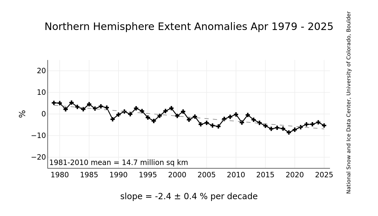
Midlands Cold Spell Discussion
in Spring Weather Discussion
Posted
This is the first time i can truly say the snow has been approaching moderately heavy since the morning. Seems like the far SW Birmingham has been rather late to join the party, especially as Stourbridge and central Brum are less than 10 miles away.
Currently 5cm of new snow today, approx 7-8cm on grass where last week's snow didn't melt.