


gpspete
-
Posts
304 -
Joined
-
Last visited
Content Type
Forums
Blogs
Gallery
Events
Learn About Weather and Meteorology
Community guides
Posts posted by gpspete
-
-
cnn news footage of joplin http://edition.cnn.c...ey.bpr.cnn.html
despite having been stormchasing with netweather as recently last week arrived home yesterday i don't think anyone would wanted to have seen this as first hand witnesses
looks like the Weather Channels Great Tornado Hunt team must have been close to this
-
arrived home from tour 2 just had asleep for 4 hrs as no sleep on plane it was full and noisy a very bumpy ride seatbelt signs on for most of flight arrived 1/2hour early and set of 15min. late suspect rode a jet stream most the way see a couple of cells with decent hight now what am i missing !!!!! looks like things are starting to realy kick off for tour 3 good luck and get some decent pics
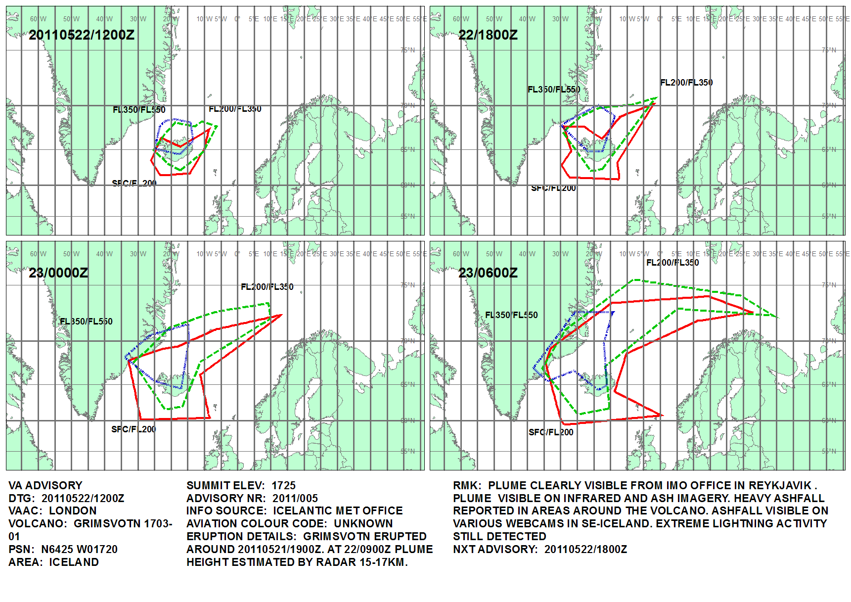
bye the way volcano trouble in Iceland AGAIN differant volcano GrÃmsvötn keep a check on latest met advisory http://www.metoffice.gov.uk/aviation/vaac/data/VAG_1306068174.png
-
2 of my pics from today
 rotating storm with a hint of a funnel trying to drop a tornado a hundred yards away
 -
trying to get some sleep got to get up 03.30 to get 4.30 bus from Oxford to Heathrow bit excited though
now what have i forgot to pack hmmmmm
what you doing Pat sitting at airport all night waiting for tomorows flight
-
My guess is that we may not be moving far from Texas in the first week. Tues looking like there is far less potential than there was two days ago. May have to think about packing soon.
every run of the models seems to show something a bit different (there it is no it isn't
back again) a big waiting game even if its only a couple of days to go lol -
plenty of lightning on the storms that tour 1 are on
-
Hmm not seeing much lightning, is it a small storm?
thats because they were driving east away from storm they have now turned around letting storm come to them just see some good lightning on cam
-
the previous post i made firmed up as i thought it would it did not push so far east as i thought as the energy pulse is slowed down a day or so so hopefull friday will be a play day also.
SPC prediction looking good for wed/thur SEVERE http://www.spc.noaa.gov/
-
my weather station lightning page Boltek LD250 http://www.bicesterw...uk/StormVue.php
and 2 links http://www.strikesta.../sslt/sslt.html hover cursor over it and you click and zoom in
-
thursday 13th SPC must be able to do something with these will check ECWMF later probably somthing a bit differant to GFS as there above disscusion
in my haste i meant to put up the charts next 6 hours on but you get the idea only looks better
mind i suspect may be in the same area that got hit hard 26/27th April
-
wednesday 11th looking good also 10th changeover day
SPC disscusion
DAY 4-8 CONVECTIVE OUTLOOK
NWS STORM PREDICTION CENTER NORMAN OK
0353 AM CDT FRI MAY 06 2011
VALID 091200Z - 141200Z
...DISCUSSION...
UPPER FLOW WILL BECOME MORE MERIDIONAL ACROSS THE COUNTRY IN THE
MEDIUM RANGE AS THE WEST COAST TROUGH DEEPENS AND THEN BEGINS TO
EJECT ENE INTO THE PLAINS BY TUE AND WED. AS THE TROUGH DIGS INTO
THE GREAT BASIN...SWLY LOW/MID-LEVEL FLOW WILL TRANSPORT A VERY
STRONG EML ACROSS THE PLAINS FROM THE MEXICAN PLATEAU. AT THE SAME
TIME...THERE WILL BE IMPROVING LOW-LEVEL GULF MOISTURE ACROSS THE
PLAINS...PARTICULARLY TUESDAY AND WEDNESDAY.
DRYLINE TSTM INITIATION IS COMPARATIVELY MORE UNCERTAIN ON MONDAY
AFTN THAN ON SUNDAY AS MID-LEVELS FURTHER WARM IN ADVANCE OF THE
DIGGING IMPULSE INTO THE DESERT SW. MORE ROBUST SEVERE EVENTS
APPEAR LIKELY ON TUESDAY AND...PARTICULARILY...ON WEDNESDAY /DAY 5
AND 6/ AS THE UPPER STORM SYSTEM BODILY MOVES ONTO THE PLAINS.
THESE STORMS WILL DEVELOP IN INCREASINGLY LARGE HODOGRAPHS AND
BUOYANCY...YIELDING THREATS FOR VERY LARGE HAIL...TORNADOES AND
DAMAGING WIND GUSTS.
BEYOND DAY 6...MEDIUM RANGE GUIDANCE INTRODUCES A INCREASING SPREAD
ON THE HANDLING OF THE TROUGH AS IT TRANSLATES EWD ACROSS THE
MIDWEST AND NERN STATES. THIS RENDERS THE REMAINDER OF THE MEDIUM
RANGE PREDICTABILITY TOO LOW TO DELINEATE SVR WEATHER AREAS.
..RACY.. 05/06/2011
hope for thursday also
-
I am just trying to work out who is arriving when and where on tour two. Here are the participants
PAUL SHERMAN - TEAM LEADER & DRIVER already there
IAN MICHAELWAITE - DRIVER already there
IAN CAMERON - GPS & TECHNICAL already there
TOM LYNCH - DRIVER & FORECASTER already there
ARRON HISCOX - (Smokes) arriving on 9th
CLARE HODGSON
RICHARD MOTT
ED - (chinomaniac) arriving on 9th
ED +1 GUEST - Chris Roberts arriving on 9th
MARTYN HOOTON arriving on 9th
PETER HULBERT - (gpspete) arriving on 9th -are you on the same 11.25 BA flight?
PAT CARTER arriving on the 9th- which flight Pat?
RICHARD COOKE - (cookie) arriving on the 10th
I think I am right in suggesting that Arron, Pete, Chris, Martyn and myself arrive on the 11.25 flight on the 9th.
Does anyone know which day and flight that Clare and Richard are on?
Chris , Martyn and I are staying nearer downtown Dallas at the Embassey Suites Dallas, Market Center, 2727 Stemmons Freeway which doesn't look to far from the Best Western.
Can't wait to meet up with everyone
Ed
I am flying with Continental on 9th leaving LRH at 09.20 to Houston then AA to DFW arrive 18.20
then meet up with Pat at BW Irvine ( found out that AA now charge $25 for checked in bags a few days back on domestic flights even though it wasnt implemented when i booked no exceptions
they must be copying Easyjet/Ryanair
) -
watching the latest GFS as they come in looks like we will need a quick getaway on the 10th
bit concerned at some of the models for when i arrive in DFW about 18.15 on monday hope there are no diverts or cancellations Heathow to Houston to Dallas Fort Worth
-
SPC discussion read the last bit
lets hope it happens and continues on for a few days at least, also something possible for the last couple of days of tour 1ZCZC SPCSWOD48 ALL
ACUS48 KWNS 040759
SPC AC 040759
DAY 4-8 CONVECTIVE OUTLOOK
NWS STORM PREDICTION CENTER NORMAN OK
0259 AM CDT WED MAY 04 2011
VALID 071200Z - 121200Z
...DISCUSSION...
MODELS DEPICT A WNWLY FLOW REGIME FROM THE PACIFIC NW INTO THE MID
ATLANTIC ON SAT/D4 WITH PERHAPS AN EMBEDDED DISTURBANCE MOVING
QUICKLY EWD SOMEWHERE BETWEEN THE NRN PLAINS INTO THE OH VALLEY. BY
THIS TIME...LOW LEVEL MOISTURE WILL HAVE BEGUN TO RETURN NWD FROM
THE SRN PLAINS INTO THE LOWER MO VALLEY. ELEVATED THUNDERSTORMS MAY
BE ONGOING SAT MORNING OVER PORTIONS OF IA/MO/IL/IND...SHIFTING EWD
AS A LOW LEVEL JET VEERS. SEVERITY OF THIS CONVECTION WILL DEPEND ON
THE STRENGTH OF ANY UPPER SUPPORT...BUT AS PREVIOUSLY ALLUDED
TO...PREDICTABILITY IS NOT HIGH AT THIS TIME.
BY SUN/D5...THERE IS STRONG EVIDENCE THAT A LARGE UPPER TROUGH WILL
BEGIN TO TAKE SHAPE ACROSS THE WRN STATES WITH AN 80+ KT MID LEVEL
JET DIGGING SWD ALONG THE W COAST. THE BOUQUET OF MREF SOLUTIONS AS
WELL AS DETERMINISTIC MODELS SHOW LITTLE AGREEMENT ON D5 WITH HOW
QUICKLY AND HOW FAR S THIS TROUGH WILL DEVELOP. THIS WILL HAVE AN
IMPACT ON THE PROBABILITY OF SEVERE CONVECTION OVER THE SRN/CNTRL
HIGH PLAINS NEAR THE DRYLINE WHERE CAPPING WILL BE A CONCERN...AND
ALSO WITH POSSIBLE NOCTURNAL CONVECTION FOCUSED OVER NEB/IA/MO/IL
OVERNIGHT WITH A SWLY LOW LEVEL JET. BOTH THESE AREAS HAVE
POTENTIAL...BUT NOT ENOUGH TO INTRODUCE ANY SEVERE AREAS WITH SUCH
UNCERTAINTY.
FOR THE REMAINDER OF THE PERIOD MON/D6 TO WED/D8...THERE WILL LIKELY
BE A SEVERE THREAT EACH DAY ALONG THE DRYLINE ACROSS THE CNTRL/SRN
PLAINS...AND PERHAPS EXTENDING EWD FROM A SURFACE LOW/WARM FRONT
ACROSS THE MIDWESTERN REGION AS THE UPPER TROUGH...AND/OR PIECES OF
THE TROUGH EMERGE OVER THE REGION.
SEVERE AREAS BEGINNING SUN/MAY 8TH AND LASTING THROUGH ABOUT MAY
10TH ARE LIKELY FORTHCOMING FOR MUCH OF THE CNTRL U.S. AS THE EVENT
NEARS AND PREDICTABILITY INCREASES.
..JEWELL.. 05/04/2011
-
look at the temprature for Wednesday 11th may hot
cape
-
caution when looking at this novice reading the storm chasers handbook as i go !
jumping forward a bit GFS looks good for the 18th may potential Oklahoma Panhandle (almost) on the 00z waitng to see the 12z
previous days back to the 11th /12th there looks to be potential perhaps Texas Hill country or a bit further east wind shear not great but there is some
there looks to be 2 jets setting up a northern and southern weaker one this looks to be evident when looking at the wind plots as you get higher, correct me if wrong as i am a novice at this.
will compare to ECWMF later/ tonight
for the 18th
back to the 11th May 12th similar but slightly further NE
-
copied from a post on stormtrack : Tuesday or Wednesday (May 10th/11th) starting to looking interesting per 02.12Z ECMWF. A large bowling ball 500 hPa low with very good meridional flow is indicated with the EC showing 60+ deg F dewpoints advecting northward across west-central Kansas and western Oklahoma. I'm not buying the 02.12Z GFS solution, however, the model has trended to less of a zonal upper pattern to more of an amplified solution. Shear looks good as well. Way to early to obsess about mesoscale details but NWP suggests more of an active convective pattern across the high plains...finally! Think its too early to start a FCST thread and still keeping the trend discussion in this longer range thread. full link http://www.stormtrac...9569#post309569
-
Overnight models have the same scenario as yesterday with not much to chase unless you want to stay in cold grey skies all day, so with this in mind will be heading back west towards the DFW Metro and stay at Decatur tonight. Looking like a huge warm up middle of this week and some action from later this week into the weekend.
Big Texan tomorrow night
Big Texan yeh i hope we get there on tour 2 some time i have orders for there Texas Armadilos got leave room in my bag for them
grandaughter wants one -
not updateing for me i am using internet exp 9
worked ok for me on ie9 but seemed a bit slow to load in fact quite a few
of websites that i visit seem slow to load on ie9 perhaps ms need to roll out some updates for it
as they will hopefully sooner rather than later unless of course they want site managers to update there code
-
cape ok will probably build as model time frame gets closer
need the jet to get a good kink in it to make a good trigger
gfs and ecwmf showing from what i can tell differances so not taking any notice of models yet
need a much closer time frame to be verifiable
postings on stormtrack bye others that hopefully know more than my casual amature knowledge seem to be saying will be ok
so everything crossed lets havesome good luck
-
is that good?
the jets too far north but looks like there may be some normal storm activity
looking forward looks to be a good reload coming but that far out including the charts i posted
not worth taking seriously yet
-
packed camera gear now unpacking it lol woken up by thunder this morning in grey murc. UK
may get to use it later on today
been peeping with one eye closed just in case at gfs for tour 2 nothing too bad
tour 1 good luck starting tomorow
slight risk Paul pulls out his magic thoughs days and got us on something sr days last year
next day
looks be a good lightning and hail day
everything crossed that you have a good time as i did last year
cannot wait to get to Heathrow on 9th may thats when the tour starts for me
-
11th May 18z
-
ariel video just been put on youtube by ABC 33/40 of last nights damage 6m30s in took a bridge out !!!


 )
) lets hope it happens and continues on for a few days at least, also something possible for the last couple of days of tour 1


 grandaughter wants one


Chase 2011 - Day 23 Discussion
in Storm Chase USA
Posted
I met this dutchman at breakfast in our hotel in norman on sat. morning before leaving for DFW airport his tour group was on the storm that hit joplin
his blog and video http://supercell.nl/