


Kirkcaldy Weather
-
Posts
6,734 -
Joined
-
Last visited
-
Days Won
11
Content Type
Forums
Blogs
Gallery
Events
Learn About Weather and Meteorology
Community guides
Posts posted by Kirkcaldy Weather
-
-
a few interesting charts within the 18z GEFS and also from one of the latest cfs runs hinting at heights redeveloping over scandi and possibly giving us the easterly that is being hinted at for January


-
 1
1
-
-
2 minutes ago, weirpig said:
Snow for the north sat night on the para
yes GFS P still the best in terms of most widespread snow
could be quite a close call between rain / snow but it might just be helpful if this ends up being a night time event with the cooler temps / dew points
-
4
-
-
17 minutes ago, Steve Murr said:
Saturdays Snow depicted by the GEM
if we want more widespread snow we will need more SE feed
looking through the 12z GEFS these 2 members seem to have the snow slightly further south than the rest (still time for the boundary between rain/ snow to move north or south in the coming runs)
-
2
-
-
3 hours ago, More Snow said:
Now got me having 24 hours of snow and heavy snow as well. Watch it jaffa cakes down with rain..
On 09/12/2018 at 14:33, More Snow said:BBC has me down for 18 hours of SNAW Friday night and Saturday. Bring it on..
On 08/12/2018 at 22:45, edo said:great post KW very helpful having the links..... i am very interested in next Friday as every year i stay at piperdam for a weekend and its always been our holy grail to be in the hottub whilst it snows so fingers crossed for Friday snow showers
found some ECM members which has the two of you in the sweet spot for the possible snow on Saturday (these will change once the 12z rolls out later tonight)
https://weather.us/model-charts/euro/perthshire-and-kinross/m24_snow-depth-in/20181215-1800z.html
https://weather.us/model-charts/euro/perthshire-and-kinross/m19_snow-depth-in/20181215-1800z.html
https://weather.us/model-charts/euro/perthshire-and-kinross/m12_snow-depth-in/20181215-1800z.html
https://weather.us/model-charts/euro/perthshire-and-kinross/m6_snow-depth-in/20181215-1800z.html
https://weather.us/model-charts/euro/perthshire-and-kinross/snow-depth-in/20181215-1800z.html
still looking good for the majority of Scotland to get some snow cover by the end of the weekend, might be temporary if the milder air can make its mind up where it is going
heres one for anyone in the SW of Scotland https://weather.us/model-charts/euro/south-ayrshire/m49_snow-depth-in/20181215-1800z.html 11 inches! (again dont take depths too literally but depending on the strength of the front / Atlantic air something in the 7-10 inch range somewhere in Scotland wouldn't surprise me)
if these kinds of charts are still showing by late Wednesday / Thursday I think we might need to get the number ready for Mr Plow to dig us out and send supplies to @More Snow and @edo who have been cut off by the snow and @edo's hot tub has frozen over
BBC also going for heavy snow here on Saturday morning https://www.bbc.co.uk/weather/0/2645298/day5
-
1
-
-
6 minutes ago, northwestsnow said:
Looks like a displacement at the moment?
Think chino has just posted in the strat thread- split is better.
Hi, as I have said before I am not overly knowledgeable when it comes to the stratosphere but it certainly looks good / interesting at the moment and given GP's thoughts for a warming on the 26th December things look like they are coming along nicely.
I was comparing current outlooks to this time in 2015 and I know which year I would prefer
predicted 2018 chart
same time frame in 2015
other years for comparison with what was being forecast on this day
2017
2016
there was an error on meteociel trying to get 2014, 2013,2011,2010,2009,2008,2007
2012
of course what happened back in February this year gave us amazing results with the beast from the east, we can end up with something that has even half the severity of that event
-
1
-
-
- Popular Post
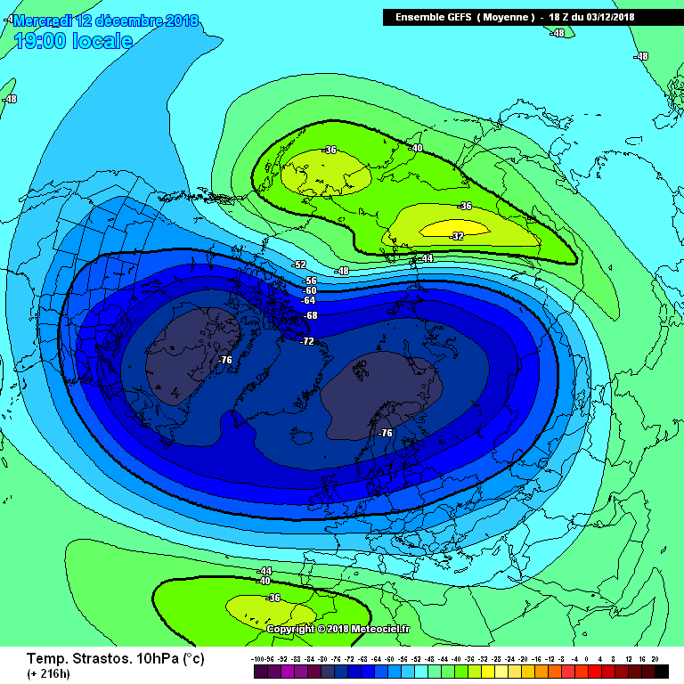
some interesting charts starting to appear at the end of the 06z GEFS, again possibly a quick reaction to the predicted stratospheric warming
06z 10hPa mean
-
14
-
2 minutes ago, feb1991blizzard said:
Good GEFS 10mb temp mean, might be a few members with SSW in there.
a few of the best looking ones looks like Santa could be bringing a stratospheric warming with him on his sleigh this year
-
3
-
 2
2
-
-
17 minutes ago, BLAST FROM THE PAST said:
Just looking at the GFS t348 to t384.....I know its deep FI....but the movement and the incredible Siberian HP ‘Backing West’ and the trigger LP.....man we’d end up 2-3 days later with easterlies from Mongolia....and an onset of a mini iceage
BFTP
these 2 GEFS members caught my eye from the 12z, possibly an immediate response to the stratospheric warming, could be some cracking charts appearing in the next few weeks I think
-
5
-
-
keeping an eye on the potential for us Scots to get some snow at the end of next week (click on the link to see the snowfall charts, tried to save and copy the image but it shows up blank)
obviously given the time frame its just a chance at the moment but I definitely wouldn't be surprised to see a frontal / battleground snowfall event across Scotland at the end of next week
GFS P also going for snow
stratosphere also looking like heating up towards Christmas
Here's to a cold / snow filled winter across Scotland (hopefully)

-
6
-
-
22 minutes ago, CreweCold said:
Yes, you can see that the warmings are now wanting to turn their attention towards attempting to strike the heart of the vortex more than we have been seeing
You can clearly see the pressure now being ramped up on the above chart. The first one looks like a strong displacement event, but the follow up that has been showing at the back end of recent GFS runs looks like it could try to deliver a killer blow.
I am not very knowledgeable when it comes to the stratosphere but this from P5 looks tasty and hopefully could lead to a knockout punch for the PV (yes its FI but it is a growing trend among the ensembles and main GFS runs)
a few other ensemble members with some sort of warming in that area at the same time frame
-
2
-
-
-8 850's over large parts of the UK and -9s moving in from the east whilst the Atlantic tries to nudge in which screams the potential for battleground / frontal snowfalls to me and still some snow showers coming from the E probably (does anybody have a link to the ECM precip charts, thought I had it bookmarked but must have lost it, cheers in advance)
-
5
-
-
18z control run some snow showers from the east then the Atlantic tries to get in = possible battleground / frontal snowfalls (obviously not to be taken to literally at the moment but positive wintry signs continuing)
somewhere could end up with a good dumping of snow if the GFS P comes off
P15 goes for a reload from the north and probably into the freezer in the week leading up to Christmas
control a bit of an outlier later on but still a good set of ensembles and the slightly less cold runs are probably more to do with the position of the high rather than Atlantic influence
-
8
-
1
-
-
some interesting charts starting to appear more frequently for us coldies, some of the better ones from a UK point of view from the 18z GEFS
blocking galore then retrogression possibly
as @feb1991blizzard says good looking ensemble graphs too
if this develops into a colder pattern it could be an interesting festive run up to Christmas
-
6
-
-
another good GFS P run with snow showers packing in from the east that this will be a growing trend for the heights to develop to our NE (scandi) during December
-
3
-
-
a few from the 18z GEFS
P10
decent ensemble graphs for here too -
4
-
-
From an article on the met office website
Meteorological winter season
The meteorological winter begins on 1 December 2018 and will end on 28 February 2019.
Astronomical winter season
The astronomical winter begins on 21 December 2018 and ends on 20 March 2019.
https://www.metoffice.gov.uk/learning/seasons/winter/when-does-winter-start
so going by that winter cannot be over as it has not even begun yet, yes a spell of weather influenced by the Atlantic has moved into the UK but will this continue for the entire upcoming winter?
given the tendency for the GFS to overdo the lows at this time of year / in FI and the fact that we have already seen heights building from scandi > Iceland and over towards Greenland in the past few weeks this could be a possible recurring pattern this winter, (anyone who is so sure that we are headed for a non stop zonal winter perhaps they could provide the lottery numbers too being able to predict things well into the future)
Even tonight's ECM has a signal for above average heights in the arctic
So in summary
Is winter over?
Will there be chances for colder weather to develop this winter?
Should people get hung up on every hr of every model run?
NO (as GP mentioned there is the chance for heights to build to our NE)
So winter is not over, highly unlikely to be zonal all winter and there is the possibility of heights rising to our NE during December.
A song to remember for those that believe it will be zonal all winter.
-
8
-
-
some nice charts from the 00z run of the GEFS Legacy
a few with some cold pooling over Europe
-
4
-
-
Just now, feb1991blizzard said:
Plenty of undercutting going on or about to go on in FI GEFS.
some lovely blocked charts, hopefully the start of a colder trend being picked up.
P12 is close to being a jackpot run ( beast from the east part 2?)
-
7
-
-
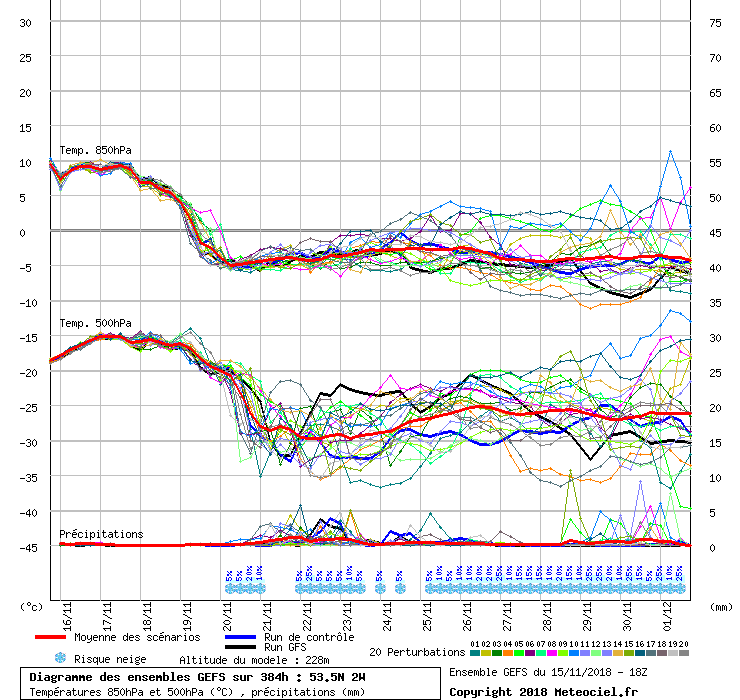
4.7C and 69.4mm please
-
- Popular Post
12z gfs control run is a thing of beauty later on in the run with a rebuild of heights across scandi and a beast from the east part 2 moving in nice to see these charts among the possibilities at this time of year rather than the usual raging pv / zonal onslaught.
still a bit of scatter on the ensemble graphs for here but still plenty falling into the colder category
-
10
-
possibly a second push of heights heading into Greenland by 192 and certainly doesn't scream raging Atlantic / zonal to me
168
192 216
-
4
-
-
- Popular Post
- Popular Post
IF the Atlantic does try to make inroads in FI always the possibility for the fronts coming in to meet the cold air leading to some snow like what P6 shows and also P11 (more marginal)
another IF is the first attempt at getting the high to Greenland, P4 weakens the first but goes for a 2nd attempt later in the run
P10 destroys the PV
P14 also has a second go at a Greenland high
Ensemble graphs still look fine for here
Kulusuk (east Greenland) still signs for pressure to rise then a bit more scatter later as to be expected
Puppebu (arctic) again still on track for a slight rise in pressure think the signals later on for lower pressure could see those lows diving south / SE possibly into scandi or towards us
Reykjavik also pressure rising and again those that lean towards lower pressure later on might not be too bad if the high has moved to Greenland by then
Think the area to focus on first before going too far ahead is the movement of the high from Scandi > Iceland >Greenland.
-
13
-
5 minutes ago, feb1991blizzard said:
-10c indeed breached.
pretty much identical for here too
lets hope the  trend continues
GEFS looking great (pretty much all are blocked these were some of the better ones for UK snow / cold)
-
8
-
-
- Popular Post
- Popular Post
11 minutes ago, ICE COLD said:Finally
think The Rock summed up the waiting for the cold air arriving in the UK on that run nicely
also nice to see the north sea snow machine firing up later in the run think there will be some great looking charts in the 18z GEFS again too.
-
9
-
1


.png.73cb3553fba0d20c9f9127344412f72f.png)
.png.6dde0d28805d5536c154a039e2fea7b3.png)
.png.ef1eed02a4654efd81801cb1c651a6ce.png)
.png.ae75d5a7575c427c8a2c89c7c390164b.png)


 192
192  216
216 


 think there will be some great looking charts in the 18z GEFS again too.
The hunt for cold - Model discussion (late November)
in Spring Weather Discussion
Posted
P17 not far off a split stratospheric warming at the end after the initial displacement event
also plenty of potential at the end of the run
P8 with some snow around just after Christmas
and a few charts showing the wintry potential for tomorrow with rain, sleet, freezing rain and snow
@More Snow