


Kirkcaldy Weather
-
Posts
6,693 -
Joined
-
Last visited
-
Days Won
11
Content Type
Forums
Blogs
Gallery
Events
Learn About Weather and Meteorology
Community guides
Posts posted by Kirkcaldy Weather
-
-
Thought it would be great to get a dedicated thread for Southern Hemisphere Snowfall akin to those for the Northern Hemisphere

 🌨🌨
🌨🌨
 🏔
🏔
-
Excellent representation of typical El Ninò patterns, this is particularly evident in the ongoing and upcoming setup throughout South America.
Snow
Multiple waves of significant snowfalls across higher elevations of Chile, Argentina and some in Peru. Significantly below average temperatures will cover Chile and Argentina in particular.

Significant Rainfall & Significant Flash Flood Risks.
Again typical characteristics of El Ninò, ongoing significant rainfall will continue with further events moving between Uruguay and South - Southeast Brazil - Rio Grande Do Sul.
Heat - Significant Heat & Potential further drought conditions
Overall warm weather covering a large part of Northern South America however the most significant heat events are modelled for Southeast Brazil which will extend across Paraguay.
After historic drought, El Niño rains pose new hurdle for Brazil’s farmers
DIALOGUE.EARTH
Soy producers in country’s south face downpours caused by El Niño, hot on the heels of a damaging three-year La Niña
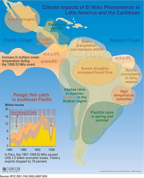
Climate impacts of El Niño Phenomenon in Latin America and the Caribbean | GRID-Arendal
WWW.GRIDA.NO
El Niño Southern Oscillation (ENSO) is a natural phenomenon that has occurred for centuries. Ocean and atmospheric conditions in the Pacific tend to fluctuate between El Niño (warming) and a drop... -
Continues to be an interesting evolution with this event, I discussed in detail in the post below
As mentioned there were many discrepancies between models on said evolution and indeed its not 100% resolved however as things look currently a few details to update and an overall summary from my POV

The main cyclonic Centre is now modelled to develop from Northern Africa (Algeria) into the Balearic Sea wheras prior outputs developed it into the Tyrrhenian as discussed in my post above.
So looking at the period of May 1st through May 3rd from a significant rainfall and associated significant flash flood threat POV, Italy and France seeing the majority however the rainfall activity which extends from Southern into more Central and Northern France will progress into the UK with current signal being the most significant accumulations and flash flood threat being focused into Southwestern England extending toward Southeast + Southern Ireland.
GFS and some of the finer scale modelling is indicating this threat area might include Central South England into Southern Wales.
Cheers, KW

-
 8
8
-
-
-
-
On 26/04/2024 at 10:40, Ravelin said:
Warming up a bit next week?
Yep one for @Hawesy it's a European plume which gives a warm East-Southeasterly


-
3
-
 1
1
-
-
On 21/04/2024 at 02:04, Kirkcaldy Weather said:
I've discussed the teleconnective feedback playing into our ongoing 500hpa developments and looking into the MJO composites with recent and ongoing progression of this cycle not surprising seeing high pressure - blocking being a prominent feature again trends continuing into Greenland. The UK trough / Low Pressure can also be noted within these MJO phase feedback. There may be opportunities for some high pressure extending toward the UK and Ireland at times though there isnt any concrete signal for this in current modelling though the 00z GEPS did hint toward the latter part of May week 1.
On 24/04/2024 at 21:37, Kirkcaldy Weather said:Could be a brief window for above average temperatures during the first days of May as High Pressure looks to build to our East.
Nothing overly surprising given MJO and overall teleconnective feedback as discussed in the above posts
.
A few points of interest I'm watching closely ATM.
A significant rainfall event develops across parts of France into the Spanish border and Italy then a low develops in the Tyrrhenian Sea and heads Northeastwards bringing further heavy snowfall in the Alps with a significant rainfall event and flash flood risk at lower elevations in Italy, possibly Switzerland and again into France during the first days of May. There are numerous discrepancies between models but could be potential for significant rainfall as the low starts to influence the UK from the East & Southeast, along the border of above and below average temperatures is where this rainfall is likely to develop with current timing heading into the 2nd of May.
Something to note from the above is we are likely to see the 552 dam air crossing into the UK from the East and Southeast which is a good indicator of warm / hot conditions which is also shown if we use the 850hpa temperatures with +10C moving in from the East and Southeast.
European Plume Event I'd class this as.
This also is evident with the most significant above average surface and upper level temperatures moving across Northern UK and Ireland.
As discussed in the first quotation in this post and from my previous posts of late, with MJO feedback and connecting with passage of above average / higher 200mb Velocity Anomalies still looks like the latter stage of May week 1 could give a window for high pressure developments from the South Southwest ie Spain, Portugal perhaps Africa etc extending toward the UK / Ireland.
On 24/04/2024 at 21:37, Kirkcaldy Weather said:Currently this looks to be brief warmth as this high retrogrades and reinforces the prominent theme for further high pressure and blocking to our North Northeast and particularly Northwest with trends hinting at the Atlantic Ridge regime by May week 2 with further trough developments to our East & NorthEast.
Really beginning to watch as the MJO feedback comes to the fore which I showed in this post
High pressure retrograding into the Atlantic and toward Greenland & Canada typically El Ninò characteristic.
-
1
-
 2
2
-
-
Interesting small cyclonic system in the Atlantic which has been given 10% to obtain tropical characteristics over the next few days
After decaying this systems moisture will become part of a Rossby Wave Break Event during this weekend into early next week.
Looks like this system spawned from a CCKW from South America
With influence of CCKW activities and the MJO itself mentioned in the above post, there will be a significant - possibly major snow event across the Himalayas as a mix of troughing and cut off lows converge by April 28th. Overall a significantly snowy setup for Russia and Asia with accompanying cold > significantly cold temperature anomalies which will extend into parts of the Middle East.
This once again coinciding with a move into a negative phase of the Arctic Oscillation.
This CCKW and MJO activity will also keep significant rainfall and significant flash flood risk events ongoing across East and Southeast China, Taiwan and Japan through at least May week 1.
-
On 11/04/2024 at 20:28, Kirkcaldy Weather said:
As shown in my post from October and other occasions a negative PNA can lead to a cold - potentially significantly cold temperature anomaly from the Northeast-East
Recent GFS outputs.
Quite exceptional performance from the GFS particularly with the European cold anomalies.
On 17/04/2024 at 22:06, Kirkcaldy Weather said:Overall a prolonged period with below average temperatures will continue with some significant anomalies across Europe in particular, we then look during April week 4 as the High retrograde gets going for these below average conditions to extend into the UK > Ireland.
The UK, Europe and North + Northwest Africa Cold Anomaly can be noted here within recent MJO feedback.
On 17/04/2024 at 22:06, Kirkcaldy Weather said:
During the latter stage of April week 3 through April week 4 the Atlantic and Ireland-UK high will begin to take on the MJO and PNA feedback of blocking to our Northeast > Scandinavia and Russia, this will also retrograde into Iceland and Greenland as discussed prior with a good representation of many of the major European weather regimes / teleconnective feedback.
As low pressure interacts with the below average temperature airmass we'll have a mix of wintry conditions with increasing precip moving in tonight combining with a Lowering Isotherm this will fall as snow particularly across Northern Scotland and parts of Northern England, predominantly higher elevations with accumulating snow though mixing of sleet snow and maybe hail can't be ruled out at low levels. We'll have the 528 dam and low isotherm values present for a number of days especially for Northern England and Scotland with a focal point clinging onto the North Sea Coastlines. We'll see multiple chilly nights with frosts for some areas worth noting for gardeners, all in all very noteworthy given its April week 4.
Could be a brief window for above average temperatures during the first days of May as High Pressure looks to build to our East.
Currently this looks to be brief warmth as this high retrogrades and reinforces the prominent theme for further high pressure and blocking to our North Northeast and particularly Northwest with trends hinting at the Atlantic Ridge regime by May week 2 with further trough developments to our East & NorthEast.
All fits excellently with feedback of El Ninò, IOBW warm phase, SSW, PNA and NAO in particular.
Credit JMA
KW
-
2
-
1
-
-
11.8C and 79.8mm please
-
-
-
I've already discussed that a lower amplitude cycle of the MJO's global progression was going to occur and also a feature linking to El Ninò but I thought this would be a good example which links with my post back in July.
A great example again that a low amplitude MJO cycle can still give active weather conditions.
Currently the main part of the MJO is travelling from South America through Africa and into the Indian Ocean. [Credit JMA]
This will enhance what I believe is a CCKW - Convectively Coupled Kelvin Wave from South Africa. As the MJO moves across South Africa and enhances the CCKW this sees significant rainfall and flash flood risks particularly off the coast of Tanzania & Kenya with places such as Zanzibar and Pemba Island prone.
Current timing shows the MJO starting to move across the Maritimes during April week 4 into May week 1. As the CCKW moves Southeastwards the significant rainfall impacts could extend into Madagascar similar to recent weeks.
I've discussed the teleconnective feedback playing into our ongoing 500hpa developments and looking into the MJO composites with recent and ongoing progression of this cycle not surprising seeing high pressure - blocking being a prominent feature again trends continuing into Greenland. The UK trough / Low Pressure can also be noted within these MJO phase feedback. There may be opportunities for some high pressure extending toward the UK and Ireland at times though there isnt any concrete signal for this in current modelling though the 00z GEPS did hint toward the latter part of May week 1.
-
3
-
1
-
1
-
-
-
'Tornadoes' leave trail of destruction across UK: Country is battered as gale force winds and 450 lightning strikes wreak havoc - damaging homes and cars and overturning caravans | Daily Mail Online
WWW.DAILYMAIL.CO.UK
The first possible tornado struck Knutton in Staffordshire, damaging cars and ripping off tiles at about 6.30am - before the second swept through the West Bridgford area of Nottingham at 7.30am.
‘Tornado’ hits town as strong winds batter the UK
WWW.AOL.CO.UK
Parks, bridges and tourist attractions across the UK were closed on Monday due to the windy weather conditions.The very active weather will continue to evolve throughout Europe with multiple significant weather events.
Snow
Ongoing significant snowfalls continuing across the Alps.
Another potentially significant snow event could swing back into Albania, Kosovo, current trends really keen into Montenegro, Bosnia and Herzegovina, perhaps North Macedonia and parts of West and Southwestern Serbia, this event currently modelled for Sunday and Monday.
There is also an ongoing snow event from the Belarusian border crossing Russia with significant accumulations.
And another area of snow intensifying as it moves across Norway again further significant accumulations likely.
Significant flash flood threat.
A significant rainfall event will develop through Saturday into Sunday across Greece and moving into Turkey, after crossing the Black Sea this could continue bringing a significant flash flood risk into Moldova and Ukraine and possibly Belarus.
-
On 29/01/2024 at 14:25, Kirkcaldy Weather said:
We'll continue seeing patterns which link to El Ninò throughout March and I'd favour potentially the first few weeks or so of April, following that time it's a gradual move into ENSO Neutral with some themes continuing of heading into La Ninà by late spring and particularly Summer 2024.
Want to start by revisiting the above statement from January, there can often be discrepancies between the various Meteorological Agencies particularly regarding ENSO statuses but we have BOM first to declare ENSO Neutral.
Per my recent post here
I discussed that the Super El Ninò Event had transitioned into more of a West Based Event, the latest ENSO discussion from NOAA agrees and gives further info
We'll have to await JMA and NOAA anouncing ENSO Neutral conditions and personally I dont get involved in debates a la Twitter last year with many arguing we weren't in an El Ninò though as I have discussed prior no 2 ENSO events behave indentically though there are common characteristics of each ENSO, and there can be lag in the Oceanic > Atmospheric 'coupling'.
Newest ENSO outlooks from Met Office suggest ENSO Neutral heading into May with the oncoming La Nina conditions intensifying in the 1 & 2 Regions quite fast.
Starting to see more details to add to some of my recent posts.
On 11/04/2024 at 20:28, Kirkcaldy Weather said:We can watch as the extremely cold airmass associated with the Tropospheric Vortex begins to move from the Russian end of the Arctic across toward the Alaskan and Canadian end. Values at -28C 850hpa ongoing possibly some nearing -30C and still maintaining at least -24C at 850hpa upon the position shift.
On 11/04/2024 at 20:28, Kirkcaldy Weather said:Trends show the coldest conditions becoming centred across Europe.
On 11/04/2024 at 20:28, Kirkcaldy Weather said:From now through Mid April we see the Atlantic Ridge regime which could extend across Ireland possibly the UK for a time, with this transitioning into blocking to our Northeast, North and most likely Greenland too.
Looking in more detail, the most significant developments upcoming, as the cyclonic system discussed here
Merges with a cut off low in Northwest America this will link to the Tropospheric Vortex which is modelled to greatly intensify with indication potentially record breaking low pressure into Canada.
Part of the MJO Indian Ocean > Maritimes feedback in an El Ninò in April as posted prior
As shown in my recent post we continue to see the Atlantic Ridge in an El Ninò setup with another cold plunge during the next few days.
Following on we have the high pressure moving into Ireland and the UK as mentioned prior plus as the Tropospheric Vortex developments occur in Canada this paired to the Negative PNA will see a high descending from West Canada across America with a new Arctic air outbreak, a relatively common pattern of the last few months which I've covered in the global thread. This will bring significantly below average temperatures.
On 11/04/2024 at 20:28, Kirkcaldy Weather said:As shown in my post from October and other occasions a negative PNA can lead to a cold - potentially significantly cold temperature anomaly from the Northeast-East
During the latter stage of April week 3 through April week 4 the Atlantic and Ireland-UK high will begin to take on the MJO and PNA feedback of blocking to our Northeast > Scandinavia and Russia, this will also retrograde into Iceland and Greenland as discussed prior with a good representation of many of the major European weather regimes / teleconnective feedback.
Euro-Atlantic weather Regimes in the PRIMAVERA coupled climate simulations: impact of resolution and mean state biases on model performance
LINK.SPRINGER.COM
Recently, much attention has been devoted to better understand the internal modes of variability of the climate system. This is particularly important in mid-latitude regions like...Nothing surprising here factoring in recent MJO progression with an ongoing probable further feedback of multiple Stratospheric > Sudden Stratospheric Warming Events, *though the current zonal winds are above average.
Overall a prolonged period with below average temperatures will continue with some significant anomalies across Europe in particular, we then look during April week 4 as the High retrograde gets going for these below average conditions to extend into the UK > Ireland.
Thanks for reading. KW
Original post: https://community.netweather.tv/topic/99814-model-output-discussion-spring-has-sprung/?do=findComment&comment=5058911 -
- Popular Post
- Popular Post
On 29/01/2024 at 14:25, Kirkcaldy Weather said:We'll continue seeing patterns which link to El Ninò throughout March and I'd favour potentially the first few weeks or so of April, following that time it's a gradual move into ENSO Neutral with some themes continuing of heading into La Ninà by late spring and particularly Summer 2024.
Want to start by revisiting the above statement from January, there can often be discrepancies between the various Meteorological Agencies particularly regarding ENSO statuses but we have BOM first to declare ENSO Neutral.
Per my recent post here
I discussed that the Super El Ninò Event had transitioned into more of a West Based Event, the latest ENSO discussion from NOAA agrees and gives further info
We'll have to await JMA and NOAA anouncing ENSO Neutral conditions and personally I dont get involved in debates a la Twitter last year with many arguing we weren't in an El Ninò though as I have discussed prior no 2 ENSO events behave indentically though there are common characteristics of each ENSO, and there can be lag in the Oceanic > Atmospheric 'coupling'.
Newest ENSO outlooks from Met Office suggest ENSO Neutral heading into May with the oncoming La Nina conditions intensifying in the 1 & 2 Regions quite fast.
Starting to see more details to add to some of my recent posts.
On 11/04/2024 at 20:28, Kirkcaldy Weather said:We can watch as the extremely cold airmass associated with the Tropospheric Vortex begins to move from the Russian end of the Arctic across toward the Alaskan and Canadian end. Values at -28C 850hpa ongoing possibly some nearing -30C and still maintaining at least -24C at 850hpa upon the position shift.
On 11/04/2024 at 20:28, Kirkcaldy Weather said:Trends show the coldest conditions becoming centred across Europe.
On 11/04/2024 at 20:28, Kirkcaldy Weather said:From now through Mid April we see the Atlantic Ridge regime which could extend across Ireland possibly the UK for a time, with this transitioning into blocking to our Northeast, North and most likely Greenland too.
Looking in more detail, the most significant developments upcoming, as the cyclonic system discussed here
Merges with a cut off low in Northwest America this will link to the Tropospheric Vortex which is modelled to greatly intensify with indication potentially record breaking low pressure into Canada.
Part of the MJO Indian Ocean > Maritimes feedback in an El Ninò in April as posted prior
As shown in my recent post we continue to see the Atlantic Ridge in an El Ninò setup with another cold plunge during the next few days.
Following on we have the high pressure moving into Ireland and the UK as mentioned prior plus as the Tropospheric Vortex developments occur in Canada this paired to the Negative PNA will see a high descending from West Canada across America with a new Arctic air outbreak, a relatively common pattern of the last few months which I've covered in the global thread. This will bring significantly below average temperatures.
On 11/04/2024 at 20:28, Kirkcaldy Weather said:As shown in my post from October and other occasions a negative PNA can lead to a cold - potentially significantly cold temperature anomaly from the Northeast-East
During the latter stage of April week 3 through April week 4 the Atlantic and Ireland-UK high will begin to take on the MJO and PNA feedback of blocking to our Northeast > Scandinavia and Russia, this will also retrograde into Iceland and Greenland as discussed prior with a good representation of many of the major European weather regimes / teleconnective feedback.
Euro-Atlantic weather Regimes in the PRIMAVERA coupled climate simulations: impact of resolution and mean state biases on model performance
LINK.SPRINGER.COM
Recently, much attention has been devoted to better understand the internal modes of variability of the climate system. This is particularly important in mid-latitude regions like...Nothing surprising here factoring in recent MJO progression with an ongoing probable further feedback of multiple Stratospheric > Sudden Stratospheric Warming Events, *though the current zonal winds are above average.
Overall a prolonged period with below average temperatures will continue with some significant anomalies across Europe in particular, we then look during April week 4 as the High retrograde gets going for these below average conditions to extend into the UK > Ireland.
Thanks for reading. KW
-
7
-
1
-
4
-
- Popular Post
Most well defined rain shaft I've witnessed in a long time.


-
13
-
1
-
- Popular Post
- Popular Post
Most well defined rain shaft I've witnessed in a long time.
-
14
-
On 09/04/2024 at 03:48, Kirkcaldy Weather said:
Looks like another Rossby Wave Break Event is likely by next weekend though exact positions of cut off lows and high pressure TBD
As the cut off low across West America via this Rossby Wave Break Event transitions into Northern States the next significant flash flood threat will evolve as the cyclonic system enters Iowa.
Newest data suggesting highest precip rates at the border of Nebraska, South Dakota and Iowa, with the flash flood threat moving into Minnesota and Wisconsin then progressing Northeastwards.
Severe weather associated with this event too.
-
On 07/04/2024 at 19:34, Kirkcaldy Weather said:
Heading toward Mid April I'm watching for a plunge of Arctic air as troughing develops to the North of the UK and moves toward Scandinavia and Europe bringing a flow from the Northwest and North.
Active period of weather with this.
Number of dynamics going on, we have a cold front which will be finishing its journey through Ireland and the UK by midday Monday.
With a strengthening Jet Streak interacting with the cold front there are a few heightened threats these being increased wind gusts with trends for embedded potentially damaging gusts and also a potential for tornadic activities embedded along the cold front I'd suggest parts of Ireland and also Wales and Southwest England being particularly at risk though it's a wide area overall.
To the Northeast of this active Jet Streak we have a deep cold pool moving in at 500hpa, this corresponding brilliantly with a pool of increased instability meaning the showers having a higher expectation of being thundery in nature and combining to the Lowering Isothermic values a wintry mix with snow mostly at high levels though not exclusively with hail and sleet to lower levels. Northwest, North and Northeast England and Scotland seeing the most of this activity.
As this Arctic plunge descends through Europe this brings yet another significant snowfall event across the Alps, a very repetitive and common occurence during this El Ninò. I'm also noticing the signal of a significant snow event in Bosnia and Herzegovina from Wednesday through Friday.
Original post: https://community.netweather.tv/topic/99814-model-output-discussion-spring-has-sprung/?do=findComment&comment=5057797 -
On 07/04/2024 at 19:34, Kirkcaldy Weather said:
Heading toward Mid April I'm watching for a plunge of Arctic air as troughing develops to the North of the UK and moves toward Scandinavia and Europe bringing a flow from the Northwest and North.
Active period of weather with this.
Number of dynamics going on, we have a cold front which will be finishing its journey through Ireland and the UK by midday Monday.
With a strengthening Jet Streak interacting with the cold front there are a few heightened threats these being increased wind gusts with trends for embedded potentially damaging gusts and also a potential for tornadic activities embedded along the cold front I'd suggest parts of Ireland and also Wales and Southwest England being particularly at risk though it's a wide area overall.
To the Northeast of this active Jet Streak we have a deep cold pool moving in at 500hpa, this corresponding brilliantly with a pool of increased instability meaning the showers having a higher expectation of being thundery in nature and combining to the Lowering Isothermic values a wintry mix with snow mostly at high levels though not exclusively with hail and sleet to lower levels. Northwest, North and Northeast England and Scotland seeing the most of this activity.
As this Arctic plunge descends through Europe this brings yet another significant snowfall event across the Alps, a very repetitive and common occurence during this El Ninò. I'm also noticing the signal of a significant snow event in Bosnia and Herzegovina from Wednesday through Friday.
-
5
-
4
-
-
Ski resorts Australia: First snow falls on ski fields almost eight weeks ahead of winter
WWW.9NEWS.COM.AU
The first snow of winter has fallen at Australian ski resorts in NSW and Victoria.
First Aussie mainland snow of 2024
WWW.WEATHERZONE.COM.AU
Snow has fallen overnight in Australia's mainland ski resorts and continues to tumble down on Tuesday morning as a cold front sweeps across southeast Australia. As a heavy band of moisture... -
Recent cold temperature records - low maximums & minimums via NOAA
*Temperatures in Fahrenheit
India
South Africa
Australia
Argentina
Chile


Storms and Convective discussion - May 2024
in Storms & Severe Weather
Posted
Marine Parade Worthing Live Webcam
Bognor Regis Beach Live Streaming Webcam West Sussex UK
Bognor Regis WestCam - Live webcam view with sound of West Beach Bognor Regis