


P-M
-
Posts
2,318 -
Joined
-
Last visited
Content Type
Forums
Blogs
Gallery
Events
Learn About Weather and Meteorology
Community guides
Posts posted by P-M
-
-
5 minutes ago, Valleyboy said:
There’s nothing to ramp if it is a northerly, as it’ll be a damp squib. We need to look east for real wintry weather. Hopefully, any northerly will back north east, east.
Depends where you are in the country. I've seen significant showers pushing down the North east coast in a screaming northerly although I agree its perhaps not the best for inland areas or those living further south.
-
- Popular Post
When will people learn not to hang on every run? Some of the pub run comments last night are laughable and just confusing.
The bigger picture looks the best we've had in years, blocking galore and a set up that really could deliver. None of that has changed but you'd think with some of the comments on here that 1 GFS run and we're going back to south westerlies and mild temps. Or the BBC weather will backtrack today. Honestly it's the same every year and the seasoned forecasters and members on here will tell you.... look at the bigger picture! Which I'd have given anything to have in recent years what we're seeing at the moment. Enjoy the hunt and thank you to this thread and forum for what it provides to this community it really is brilliant.
-
 25
25
-
1 hour ago, Don said:
I understand this has happened a lot in recent years but the PV has then ramped up to very strong levels come early winter?
Hopefully the dice will land in our favor this time!

-
- Popular Post
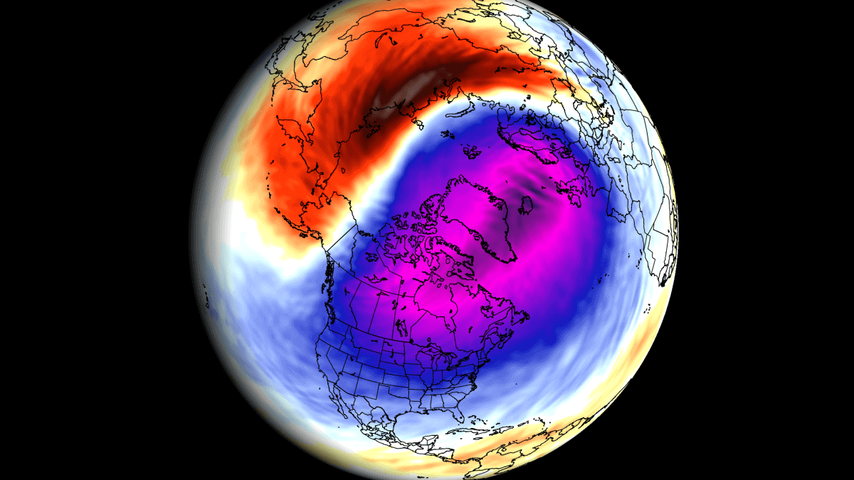
Not sure if this has already been posted somewhere, but really interesting read about the polar vortex and how it's already being disrupted. The article suggests some bigger implications for the NH as winter progresses.
 Weather: An early disruption event is starting for the Polar Vortex, with pressure anomalies setting the stage for something bigger later in Winter » Severe Weather Europe
WWW.SEVERE-WEATHER.EUA stratospheric disruption event is starting over the North Pole, affecting the Polar Vortex and potentially having an impact on the...
Weather: An early disruption event is starting for the Polar Vortex, with pressure anomalies setting the stage for something bigger later in Winter » Severe Weather Europe
WWW.SEVERE-WEATHER.EUA stratospheric disruption event is starting over the North Pole, affecting the Polar Vortex and potentially having an impact on the...-
7
-
 3
3
-
Some intra cloud flashes and bangs before shotgun thunder overhead here in Washington. Not a big storm but some decent rainfall with it. I'm happy with that!
-
8 minutes ago, The PIT said:
Looks like the SE and Far east of the England the place to be later on.
Far east of England meaning east anglia etc?
-
25 minutes ago, Peachy said:
Many cells will start developing in the next hour over much of southern and central England.
Things are about to get interesting soon.
Do you think there's any chance of them moving north into Northern England? I'm really disappointed tonight!
-
4 minutes ago, Cakie said:
Pouring down again with a few rumbles
It's weird because by the time it moved only 30 miles north (pervious storm) it was moderate to heavy rain and some distant rumbles. Not expecting anything else tonight if I'm honest or if I do it'll be a massive bonus.
-
15 minutes ago, Cloud 10 said:
Just had a rumble of thunder here and quite heavy rain which should help with those extreme pollen levels of the last few days.
Not the storm I was wanting though lol
You honestly couldn't make this up. Merges grows then dies as it makes a direct hit over my location. Some heavy rain though which has taken the edge of the humidity I suppose.
-
1
-
-
4 minutes ago, Cakie said:
There wasn't much when it came through on the Lightening on option on the radar but it was a beefy, short little storm non the less. Looks like it's getting more energy and heading straight your way. Fingers crossed for you
I can hear the thunder now. Sky is turning a deep slate grey so here hoping! Its still a few miles south of me yet. The cells to the east of me have activated too now I can hear thunder from both sides.

-
1
-
-
10 minutes apart... come on keep it going
Edit: appears there is nothing electrical from this now on the lightning maps.
-
1
-
-
3 minutes ago, Cakie said:
It’s just passed through Darlington. It was short but intense rain and wind. A few flashes and rumbles then one almighty clap of thunder. 5mm of rain in less than 10 minutes. Short but sweet
Cheers Cakie it looks like it's grown a little. See if it makes it this far!
-
1
-
-
Is anyone under that cell trundling towards Tyne and Wear? Wonder if it's just a standard thundery shower.
-
I'm the little red dot near Sunderland. Would be great if that cell near Darlington grows a little more to the east and stays electrical
 I'm finding it hard to work out which direction they're going in, north or northeast??
-
4 minutes ago, Jamie M said:
Teasing scud there off one of the storms, have a slight feeling this 'lowering' could just be the formation of a shelf cloud if the third picture is from the same storm.
I think I've been watching this cell on the radar for a while now. It's breaking away from the main bit of PPN from what I can see and has / is definitely intensifying as it moves north. Not sure if it will maintain, grow or just fizzle out yet. I try not to get too excited in these set ups lol
-
Light covering and more incoming on the radar.
-
3
-
-
I've just been woken up on the sofa jeez it's wild out there tonight!
-
1 minute ago, Steve Lynn said:
Winds starting to pick up and the radar looks wintry, our best chance for snow sticking I think is Saturday night into Sunday morning away from the near coast. The strongest of the winds incoming!
Hope it ramps up a bit it's just a minor breeze here and I'm right on the west of the red zone lol
-
Still not much happening here. Just a wet and breezy night.
-
2 minutes ago, Cloud 10 said:
Lights starting to flicker now,lol.
Latest sat.pic shows the LP pretty well.
Not much happening here in Washington to be fair. I'm right on the eastern edge near the A19 so bang on the red zone but maybe it's not going to be too bad here.
-
15 minutes ago, Man With Beard said:
Still quite a range of mac wind speeds on the models even at T9, interesting to see which is closest with future events in mind. Bear in mind with these charts, peak winds will reach places like Newcastle/Sunderland a few hours later
ICON is way out in front with 122mph, at 9pm tonight
Some models still just over 100mph, including UKMO below
Many models around 90mph or just over, but GFS peaks at "just" 85mph, which is the lowest end of the spread
Thanks for sharing these MWB. Can I just ask where these are from? Are there any that show further south and the wind gusts later in the evening / overnight period? I'm curious about North east England and populated areas etc
-
20 minutes ago, Chris Smith said:
Full-on snowing now.
It snows in summer there man But seriously glad you're seeing some!
-
Main wind event for evening and overnight hours for Tyne and Wear. Going to be interesting to see if this actually pans out as predicted....
-
4 minutes ago, North East Blizzard said:
Sunderland is pretty much on the coast tbh, only a couple of miles, if that away. Dangerous situation for sure.
It is but it stretches miles inland too. So Sunderland right on the coast yes I'd expect but places further inland I was curious. Newcastle is few miles inland and Washington where I am part of Sunderland but about 7 miles as the crow flies inland.
I can't recall seeing charts like this for low lying areas this close to a wind event it's crazy.


Model Output Discussion - moving into Winter
in Forecast Model Discussion
Posted
I agree with you. I was responding to the other poster about northerlies being a damp squib. All of the above I agree with as it loads with potential. Great starting point for a December.