


Dave Kightley
-
Posts
523 -
Joined
-
Last visited
Content Type
Forums
Blogs
Gallery
Events
Learn About Weather and Meteorology
Community guides
Posts posted by Dave Kightley
-
-
Gem makes more of the warm sector. Nae is one to follow now

-
00z are getting closer.... Typical we are so close to the centre though. Parts of the N.e of the region might get lucky on the Nae 00z
-
I think the Nae backs up the ECM mean with the centre in the channel rather than Wales. Might be wrong though..The nae must be wrong,most of england is bone dry.....huge model disaster across the board if this right.
-
The centre of that low will properly need to be over North of France and if so all the models are poor if it does.I Agree Dave
-
that's nasty Steve. Way things are going I won't be surprised of another 30 miles south with that snow line on the 12z.
-
UKmo 144h looks quite flat to me.. Not great
-
UKmo wants to go for that low too. Not sure if its any good though. Again....
-
any chance for the s.w Steve or rain to snow into the evening. Looks better then GFS with less of a warm sectorExcellent UKMO at 42/48
http://www.meteociel...48-21.GIF?09-04
Expect snow warning area to extend into London & the SE -
temp at 48 from unmodified raw is 1c.
Very good for the midlands esp east.
T60 still snow in the SE.
Looks very good as well for convective snow in the E of scotland & parts of the NE
S
-
still that chance just... Think Monday morning might get interesting yet for some parts of our region.. Gunna be interesting how this pans out.Met dep cheif forecasters view, note the uncertainty aspect, even with high res ensemble forecasts! If we are very very lucky we could get buried If our luck is average then north of the region could see something, if we are unlucky...alll rain.
-
I see where the cold gone now.... won't happen like that.Slight milder a t240 as the high dominates
-
GFS 18z Is poo. I just have this gut feeling Sunday will not be our time...
-
Op isn't just important. Met office the ensemble part
-
Getting pushed back each time though. We had break down end of this weekend one point.. Tuesday, Wednesday now as you say Friday.Disappointing ecm 12z really,azores high moving in on friday.
-
Gem is the run of the day for us.. Shame it's only the gem but the other are trending west which is good. Come on ECM!!'
-
Is that today's 12z run mate?Erm, I'm not sure if I should be posing this, but it somehow got onto twitter in the first place, so feel free to take it down if required, but this is the modified UKMO-GM for Monday... Many people will be pleased with this:
-
Very good trend so far of the low pushing further west... Lets hope it keeps up that trend over the coming days..Ukmo is also further west but still rain at the moment.
-
shows snow by Sunday evening ateWell latest gfs looks pants for our area , by the time it get's Cold enough the precipitation has cleared .. Let's hope for some greater shower potential on Monday.
-
ECM and GFS are good for a rain to snow event as I stated and also that' shortwave around Greenland being a what not reflected in the GFS and ECM output until 192h hours. I rushed into it but still all fl. can't say they we're great runs. The cold uppers are gone by Wednesday.Not just the S/E http://www.meteociel...&ech=114&mode=2
Most of central and eastern UKDave Knightly....get some sleep you are delerious..
-
168h poor.. Model agreement on a shortwave being a pain in the I have a problem.
-
I can't see a way back to cold on that UKmo 144h or GFS. You would hope the next frame on the ukmomwould go for a slider. Just to Far East. Very disappointed.
-
Slightly further west on the GFS 00z
-
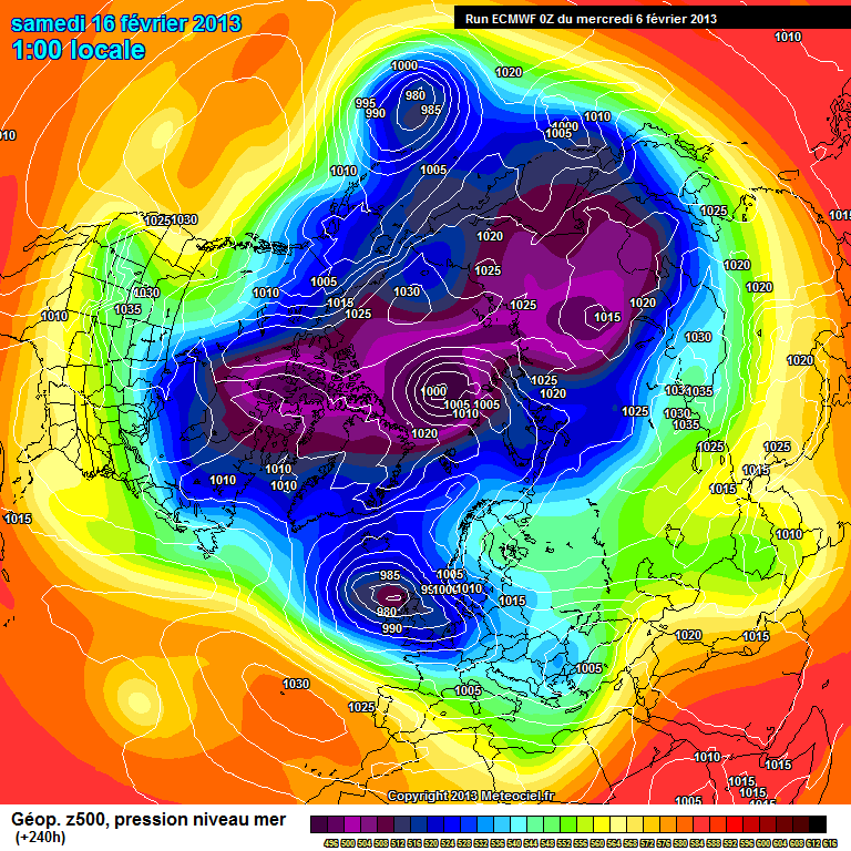
I'm surprised the block gets pushed so easily.. UkMo looks better over Greenland and makes less of the feature behind our low Sunday. We will see.Heights to our N/E are itching to move westward at 240 http://www.meteociel.fr/modeles/ecmwf/runs/2013020600/ECH1-240.GIF?06-12
Depends on how far south the low digs.I cannot see much more energy to our N/W ready to be fired at us.Possible height rises to come.
-
216h no heights to the n.e left. I think it would be rain with ridge building in Atlantic on 240h.to Far East anyway...
-
There a secondary feature behind this low causing the problems. UKmo makes less of it then ECM.


 Most of central and eastern UK

Winter Model Output Discussion -12Z 07/02/13 onwards
in Spring Weather Discussion
Posted · Edited by Dave Kightley
ECM is ok. Makes less of the mild sector 1am Monday all under colder uppers again. Colder then some other runs anyway..