- Popular Post
-
Posts
172 -
Joined
Content Type
Forums
Blogs
Gallery
Events
Learn About Weather and Meteorology
Community guides
Posts posted by coldwinter
-
-
-
The amount of disrespect on here for people who actually try and understand and analyse the atmosphere and how what is happening in the atmosphere at the time is going to effect the northern hemisphere going forward makes me wonder why the likes of GP bother posting on here at all.
-
 5
5
-
-
-
1 minute ago, Mucka said:
GEM 12z appears to have frozen, maybe an omen?
(Think you meant West Nick?)
Further east in FI I think he means
-
 1
1
-
-
-
6 minutes ago, feb1991blizzard said:
is it continuing in the extended eps though is the big question?
The signal on the EPS anomalies for a atlantic/Greenie high Is right at the top of the scale. if anything, its getting stronger than the last few EPS!
-
 5
5
-
-
25 minutes ago, nick sussex said:
Just looking at the latest ENSO update from NOAA .
In terms of the current La Nina , after a big drop in ssts during October recent weeks have seen a stabilization which is good news.
We want a weak La Nina with the coldest ssts centred over the central Pacific. This has in the past correlated with below average winters in Europe.
This also means the MJO can play a bigger role rather than the signal being muted. Of course there are other teleconnections to factor in but we don't want to be facing an uphill battle against an unfavourable ENSO signal.
PS for new members heres the ENSO regions:
Interesting, the research of Wenjun Zhang however found a correlation between an eastern pacific based La nina with a negative NAO. And central based with a +VE NAO.
https://link.springer.com/content/pdf/10.1007%2Fs00382-014-2155-z.pdf
-
 1
1
-
 1
1
-
-
-
8 minutes ago, CreweCold said:
Who has said that winter is over because the CFS is showing mild?
Of course it can be used as supporting evidence to compliment a plethora of further pointers such as the cycles within global climatic drivers and other background signals. The same is true of other long range modelling tools such as the GLOSEA.
Flippant remarks such as yours add nothing to the thread, and rather undermine those of us who actually want to get our head around such drivers, signals and NWP tools.
You don’t need to explain. I’m just not sure what adding ‘The writing is on the wall for December’ adds either.
-
 9
9
-
-
4 minutes ago, bluearmy said:
Worth making a note of the TD showing up in the west Pacific week 2 - that's the second run I've seen that feature and if it were to be able to be picked up into the general flow arcing out into the n Pacific then that really could be game on for December from a hemispheric perspective as we already see a propensity for amplification on the Pacific side in any case.
But I thought winter was over as the incredible CFS is showing mild?
-
 1
1
-
-
2 minutes ago, bluearmy said:
They were on board for early December cold and snow last year .......
Selective memories

-
-
-
5 minutes ago, Daniel Smith said:
I agree. Using ensemble means that far out is about as useful as asking the local garden slug what he thinks the weather is going to do. Ensemble means are drastically washed out and don't really offer anything of use.
The operational runs have continuously gone for Siberian High/Greenland high for the past few days, there have been changing details with regards to whether the UK gets cold or stays mild but the main trend for heights to the North have remained the same. Not much change on the 12z GFS so far either, could be on for another stella FI.
The Siberian high and Greenland high have been present in the extended on the ENS for days. Of course seeing the ensemble mean clusters always helps but they are extremely useful.
-
Very solid agreement in the extended between GEFS and ECM EPS
Interesting to get such agreement in the extended. If we can get this big Siberian high and blocking to develop it would not only help with cold chances for the back end of this month, (I note the met are saying dry and below avg temps) but in the long term. Strong Siberian high--->Increased wave activity/poleward heat flux---->weakening of the polar vortex--->-VE AO--->higher chance of colder weather. All speculation for now but an interesting start to the season.
Ryan.
-
 3
3
-
 1
1
-
-
- Popular Post
- Popular Post
Surprised there hasn't been more chatter about the ECM ens this morning. Very impressive ensemble mean with a strong blocking signal out to the end of the run from Scandinavia through the Taymyr region to the Aleutians, signal for troughing into Europe too.
Only two clusters on the ECM ens right at the end, big signal for blocking over scandi on the biggest. Even the second has a signal for blocking to the north. Certainly, if this were to verify it would put the polar vortex under some stress, along with a possible strong Siberian high forming. I notice the 06z GFS has also cottoned on to the Siberian high theme. Would expect some decent wave activity if this comes off? Interesting times.
Ryan.
-
 16
16
-
34 minutes ago, Allseasons-si said:
Good post Bobbydog

It seems people are wanting snow on there doorstep....in October and a repeat of Oct 2008,this is very rare in our neck of the woods and there is plenty of time yet
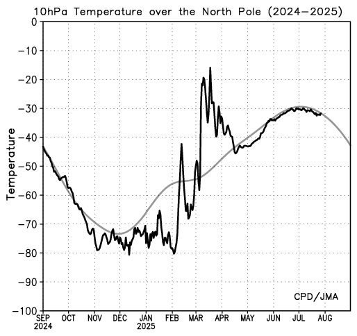
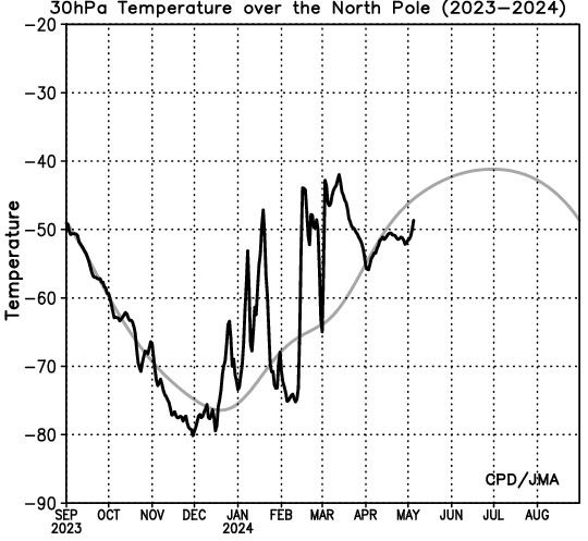
anyways,back on topic,i have been keeping an eye on strat proceedings and here is the 10 and 30 hpa temps over the north pole,yes not much of a warming as of yet but there is a slight uptick there
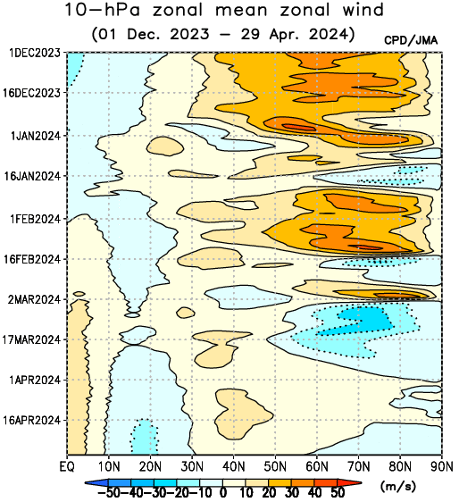
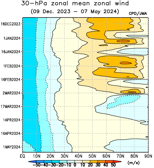
10 and 30 hpa zonal mean zonal winds and as you can see on the bottom right the oranges(if i am reading these charts right) marking a drop off in wind speeds but i would like to see reds in there but maybe not this early on into the season
http://ds.data.jma.go.jp/tcc/tcc/products/clisys/STRAT/
i will continue to keep monitoring these as we progress into the season

and just for a bit of fun,it's hotting up in the north pole...1216c


will the ECM follow the the earlier runs from the GFS or will it stick to the same old record it has been for the last couple of days,will the GFS switch to it's earlier runs with bites at the cherry,a cherry isn't very big

Reds would show strong zonal winds. Not what we’d want to see if you like cold!
Ryan.
-
30 minutes ago, Nizzer said:
BIB. Nail, head and all that jazz. If it wasn't so rare and we had a Siberian Winter every year, we wouldn't crave it like we do. It doesn't happen that often in this country, which is one if the reasons why (to me anyway) we love it so much.
Part of the fun every Autumn/Winter on Netweather is the chase, and the people on here that contribute.
Exactly! It makes it so magical when we actually see a few flakes off the white stuff actually falling from the sky!
And I agree, some extremely knowledgeable people on here make it so much fun, I will be watching what happens very closely over the next month or two with the view of making a winter forecast. Seeing where the defined ridges and troughs set up and how the atmosphere shapes up is fascinating and crucial to any forthcoming forecast!
Ryan
-
 3
3
-
-
1 hour ago, weirpig said:
Yep i agree wasnt the SAI last year the highest its ever been in regard to snowfall accumilation and last winter was hardly the best yet we still put faith in that.
They are all pieces of one very big puzzle, one of which I believe we know little about. So many different factors can influence what we experience but I think we have been very unlucky in recent years with regards to cold and snow. Last year had so much promise with an extremely weak polar vortex but things didn't quite fall right. That's why a lot of us on here love the snow so much!
Ryan
-
 1
1
-
-
Its a shame the OPI didn't return, it obviously wasn't 100% but no type of prediction index ever is. It was linked in with Cohen's snow cover advance theory, the opi just gave us a number that reflected the pressure pattern across hemisphere, the pressure pattern that determines how fast the snow cover builds up! Its all linked, the OPI, taymr peninsula index and snow cover advance, basically one thing. The patterns throughout autumn set up what will happen in the following months, October is where things start to get interesting with regards to winter for me.
Ryan
-
 1
1
-
-
-
- Popular Post
-
1 minute ago, Nick F said:
I'm not implying it does happen. But there are old empirical rules of thumb, before NWP advances took away the need so much, that I have seen journal articles or in met papers or books, for particular synoptic evolutions to develop, be it a Spanish Plume, types of cylogenesis, anticylones formation in certain areas, etc. The antecedent to a Scandi high is normally a N-S aligned lobe of the PV over Greenland and over Scandi, a ridge forms between the two lobes, eventually the Scandi lobe relaxes and cuts-off S into S/SE Europe. This then allows a cold surface high to form over Scandi supported by a 'warm' ridge aloft. The Scandi sometimes re-enforced by either an arctic high (think '87) or Russian high (think current EC det).
Something like this?
-
 7
7
-
-
7 hours ago, northwestsnow said:
Really interesting stuff , the duel between that high and the Atlantic looks finely poised. 18z would produce a real mix possibly inc some wintry stuff in the North.
Certainly nothing mild showing on the models at the moment!
-
 7
7
-


.thumb.png.4f4431adbff8252044cd2a6b7938899c.png)

Model output discussion - Post SSW - Will it turn cold?
in Forecast Model Discussion
Posted
Christ give everyone a minute to enjoy their passion. The majority knows the caveats but this is what some of us stupid cold fans live for! Cmon....