


Gordon Webb
-
Posts
1,708 -
Joined
-
Last visited
Content Type
Forums
Blogs
Gallery
Events
Learn About Weather and Meteorology
Community guides
Posts posted by Gordon Webb
-
-
I must be one of few people who don't want storms but seem to be in a locale this year that keeps getting them and this week seems no exception , must have accidentally kicked a black cat or something
-
 2
2
-
-
27 minutes ago, Summer Sun said:
Day 1 Convective Outlook
VALID 06:00 UTC Tue 11 Aug 2020 - 05:59 UTC Wed 12 Aug 2020
ISSUED 07:06 UTC Tue 11 Aug 2020
ISSUED BY: Dan
... SUMMARY ...
- A few isolated elevated thunderstorms will be possible E Scotland and E England during Tuesday daytime
- Elevated showers/thunderstorms possible over SW England during Tuesday daytime
- Depending on strength of the cap, isolated to scattered explosive thunderstorms will be possible in parts of England and Wales by late afternoon into the evening - many areas within the SLGT will remain void of lightning. Any storms that do develop pose a threat for large hail and flash flooding
- An increase in thunderstorm coverage, primarily elevated, is expected from Cumbria northwards across a swathe of Scotland during Tuesday night
- A few scattered elevated showers/weak thunderstorms will be possible over the Channel Islands / English Channel on Tuesday night
... DISCUSSION ...
Decaying MCV over Scotland on Tuesday morning has considerably worked over the environment last night. However, with a PV lobe aiding ascent, there is an ongoing risk of some sporadic lightning on its eastern flank from elevated convection through the morning as it continues to lift north and ultimately offshore. The same instability plume extend SSE-wards across eastern England, and continues to run a risk of a few isolated elevated thunderstorms developing this morning/early afternoon - some model guidance suggests this perhaps most likely from East Anglia across the East Midlands to Yorkshire. There may also be an uptick in elevated activity across central/eastern Scotland during the afternoon hours on the tail end of the morning MCV. other elevated showers/thunderstorms may also drift from the Brest peninsula towards SW England through the day.
Elsewhere, it may be rather quiet for much of the day with an EML covering much of England and Wales and acting as cap to surface-based convection. Diurnal heating will lead to 1,000-2,000 J/kg CAPE building through the day, essentially once again creating a loaded-gun environment. Surface dewpoints may mix out a little, especially towards southern and eastern England where the hottest conditions are most likely. Nonetheless, it seems likely dewpoints of 19-20C will be fairly widespread, especially late afternoon and into the evening. The slack surface pattern will lead to several convergence zones developing, and these combined with orographic forcing will be crucial in providing forced ascent given the lack of any upper support. Forecast profiles suggest air temperatures of 32-33C in SE England to 29-30C in Wales will be required to break through the capping inversion. Where this in conjunction with low-level convergence occurs, explosive deep convection could evolve by late afternoon and more especially into the evening hours almost anywhere in England, Wales and southern Scotland.
NWP guidance varies drastically as to where these convergence zones may develop, in part related to the events from Monday night, and so it is difficult to pinpoint specific areas where storms could fire. Bulk shear is a little on the weak side (15-20kts), but steep mid-level lapse rates and significant CAPE (fast upward motion) suggests that where storms do develop, the threat for large hail exists in the most organised cells (2-4cm in diameter). Inverted-V profiles suggests localised wind gusts of 40-50mph may occur, and with PWAT of 40-45mm and storm motion of ~15mph prolonged torrential downpours could lead to flash flooding. A SVR has been issued primarily for the threat of large hail and flash flooding, and to a lesser extent for damaging winds.
Most surface-based storms will probably only last a couple of hours given the strong cap in place and lack of notable forcing aloft - however, the shortwave associated with elevated thunderstorm activity over SW England today may allow thunderstorms that do erupt over Wales and the West Country to persist through the evening hours as they track northeast across the Midlands. There is better agreement on a developing shortwave running northeast from the Irish Sea into northern England and Scotland on Tuesday evening and night, and this may lead to another wave of elevated thunderstorm clusters over these areas during the overnight period, with any activity across central and southern Britain generally quite isolated through this time.
http://www.convectiveweather.co.uk/forecast.php?date=2020-08-11
I was quite happy until that bit about storms possibly tracking across the midlands
-
3 minutes ago, JON SNOW said:
I think the ECM 0z operational speaks for itself, just look at these uppers (850’s) for preety much the next week or so..
 ..astonishing!!!!..meanwhile the intense heat and humidity continues across the s / se...

they do decrease day on day though , not to anything particularly cold but something more bearable
-
 1
1
-
-
Estofex Important bit
(2) Great Britain, Belgium, rest of France, Switzerland, N Italy:
The capping inversion on top of the moist boundary layer and limited synoptic lift could keep the storm coverage rather low, but the conditional severe weather risk is notably enhanced once storms initiate. The main risk is excessive rain due to plentiful low-level moisture and slow storm motion. However, steep lapse rates in the "Spanish plume" also enhance the risk of large hail and severe downbursts even in the absence of noteworthy vertical wind shear.
Confidence in surface-based storms is limited in England (where the ratio between capping and lift deteriorates), and in general turns very low in coastal areas. Elevated activity on top of the sea breezes or in the warm air advection regime in Great Britain can still bring some heavy rain, but the other risks are significantly lower.-
2
-
-
3 minutes ago, Flash bang flash bang etc said:
What’s going on with the lack of any storm forecasts?
well here's one
Severe Convective Weather & Storms Forecast - Netweather.tv
WWW.NETWEATHER.TVmainly elevated today according to this
-
2
-
-
14 minutes ago, AMeltedFlake said:
Are these the severe storms modelled in the midlands? Or will that be a bit later tonight?
I think so , convective weather and met office had storms firing from afternoon moving N/NW and clearing on in the evening but speed of these things could mean that's it or vice versa or more could keep going a few miles from you all evening pretty hard to judge but the cap did seem to go where it was expected
-
1
-
-
5 minutes ago, Xanderp009 said:
A Nice celebration of the Viking God Of Thunder on Thursday
would've been better if your used Thorsday instead of Thursday
-
3
-
-
4 minutes ago, DIS1970 said:
Not too much on the go here, may just be outside the firing line, may be wrong, but it looks like it's just to the NW, of Wolves - at the moment.
well the met office 4pm storm warning only has Wolverhampton just in the southern edge of the zone so perhaps you'll be unlucky
-
storms seem to be where the met office 4pm warning starts
-
I know the GFS is a source of amusement but somebody did post on the model thread a few days that GFS had shifted the activity for Monday further North , Know it's not much but a little win for the GFS in a run of losses
-
23 minutes ago, Mapantz said:
60 mm of rain is possible in an hour with a very small chance of 150 mm in 3 or 4 hours.
From the MetOffice.
just for clarification that is a separate warning from the general thunderstorm and covers 16:00 to 03.00 and from Birmingham North Westwards into Wales and NW England , thankfully I'm just to the SE and not included in that warning so should miss most if not all of that and that pretty much ties in with other forecasts
-
20 minutes ago, Ndc Ozzie said:
Although I got temps forecast to hit 29-31 I fear I'm to far S/E for anything storms to break out,I think it more N/W of here tbh
Birmingham Westwards for the midlands I reckon
edit - this is completely an opinion and based on no data whatsoever
-
2
-
-
3 minutes ago, DIS1970 said:
Not even touched 19C here yet, and still fairly cloudy - going to be a watch and wait theme.
same here cloud has thinned but not exactly gone away , also have to bear in mind that the 2 biggest words in all these forecasts is IF and POSSIBLE
-
1
-
-
1 minute ago, MAXcrazystorm said:
My final storm watch update for today.
look to be just on border between slight and low
-
1
-
-
little shower just north of me at the moment
-
1
-
-
all these moving in a NW direction it seems
-
1
-
-
45 minutes ago, MAXcrazystorm said:
if the Midlands get into the low 30s then storms should ignite
yep but only got 26c here yesterday due to cloudy morning and it's still relatively cloudy again this morning with a breeze too
-
1
-
-
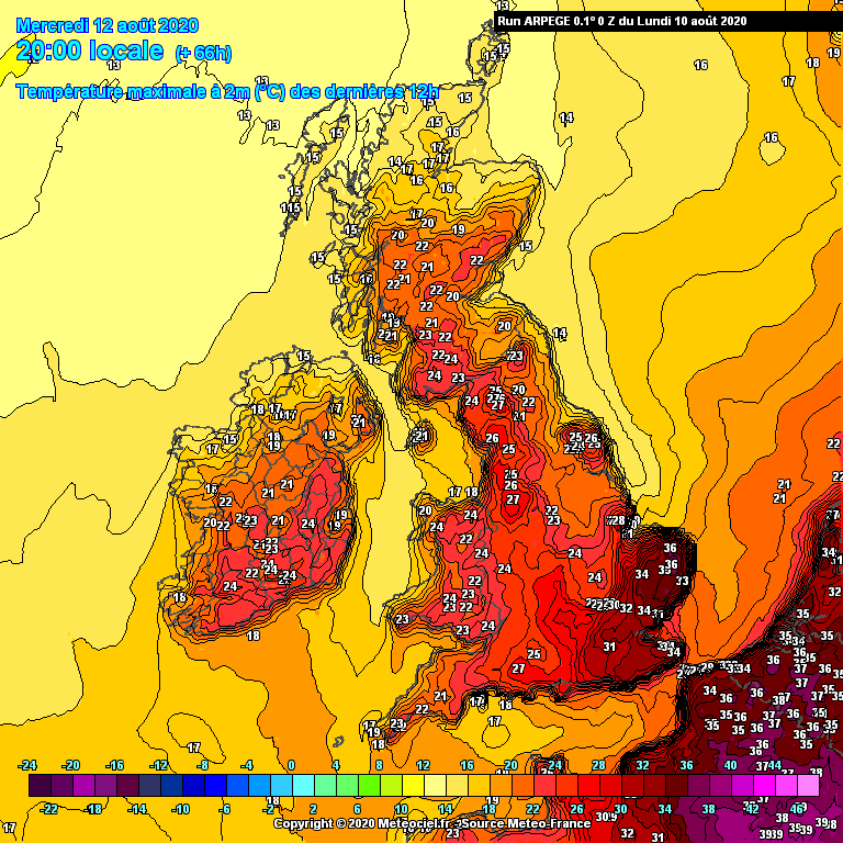
6 minutes ago, Yarmy said:
Arpege has a max of 36C in Norfolk on Wednesday which would be pushing the local record (made last year):
it does seem to keep the heat more focused for the E/SE
-
1
-
-
Day 1 Convective Outlook
VALID 06:00 UTC Mon 10 Aug 2020 - 05:59 UTC Tue 11 Aug 2020
ISSUED 06:25 UTC Mon 10 Aug 2020
ISSUED BY: Dan
Atlantic upper longwave trough will gradually sharpen on Monday, placing the British Isles under a broad southerly flow aloft. This will continue to advect a plume of high Theta-W slowly northwestwards through the forecast period, with a marked elevated mixed layer (EML) covering much of England and Wales and creating an environment with notably steep mid-level lapse rates.
... SUMMARY ...
Scattered thunderstorms are likely over parts of Wales / SW England / Irish Sea / SW Scotland during Monday daytime
Severe thunderstorms with large hail, flash flooding, strong gusts of wind and an isolated tornado will be possible over the Midlands and E Wales during Monday afternoon and evening
Scattered thunderstorms may affect parts of N / NW England, Irish Sea and southern Scotland on Monday evening and night
Isolated thunderstorms may be possible elsewhere, but with lower confidence
... WALES / NW ENGLAND / IRISH SEA / SW SCOTLAND - MONDAY DAYTIME ...
Elevated convection (bases around 8-10,000ft) is likely to be ongoing on Monday morning across parts of Wales, SW England and perhaps NW England, lifting gradually north through the day while expanding in coverage as a shortwave engages with a Theta-E ridge. Given the steep mid-level lapse rates and 500-700 J/kg CAPE, lightning is likely to be quite frequent in the most intense cells - especially over west Wales and parts of the Irish Sea where a greater coverage of lightning is expected. Lightning activity may weaken as storms approach the Isle of Man / eastern Northern Ireland / SW Scotland as profiles become increasingly saturated and instability weakens. Some hail may be possible, although the high cloud base and depth of hot air below suggests a lot of this will melt or shrink in size by the time it reaches the surface.
Elsewhere, isolated elevated showers/thunderstorms will be possible in a zone from Wales across the Midlands and SE England as a weak PV filament lifts north and engages the plume.
... MIDLANDS / E WALES - MONDAY AFTERNOON / EVENING ...
Strong surface heating is expected across southern and eastern England, with a slack low evolving in the vicinity of the M4 corridor. The EML will serve as a cap to surface-based development, and with T850s gradually warming through the day across SE England and East Anglia, these areas are likely to remain capped. However, some slight cooling at 850mb is possible over the West Country / SW Midlands, and IF surface temperatures can nudge close to the required trigger temperature of 30-32C (assuming dewpoints around 18-19C) this could breach the capping inversion and lead to explosive development in a loaded-gun environment, especially when aided by low-level convergence near the surface low centre and a PV lobe arriving from the English Channel.
Should deep convection occur, the backed low-level winds north of the surface low and modest flow aloft will create 20-30kts DLS which may be sufficient for organisation and perhaps supercellular mode. Given the substantial CAPE (1,000-1,500 J/kg) and steep mid-level lapse rates, very frequent lightning and large, damaging hail 2-4cm in diameter would be possible (although possibly shrinking somewhat in size as it falls through the hot surface air before reaching the ground). PWAT near 40mm and storm motion of ~20mph brings the risk of prolonged torrential downpours and flash flooding. Should storms exhibit supercellular characteristics, then they may deviate to the right of the mean flow and slow their forward speed. Given the large T-Td spread, cloud bases may initially be quite high, around 6,000ft - but due to a combination of storm processes, northward movement into less-hot air and nocturnal cooling of the boundary layer, cloud bases may steadily lower during the evening hours. Backed low-level winds will create 20-30kts LLS, which may bring the risk of an isolated tornado if cloud bases can lower substantially. Otherwise, inverted-V profiles suggests the risk of strong downburst winds 45-55mph. A SVR has been issued primarily for the threat of large hail and flash flooding, and to a lesser extent for strong winds and an isolated tornado.
The greatest risk of severe thunderstorms appears to be initially close to the M4 corridor and SE Wales, shifting northwards into the south / central / west Midlands and east Wales during the evening, and then NW England / Irish Sea later. However, as storms run north into an increasingly capped environment, they may become more elevated in nature. Much of this depends on how strong the cap is during Monday afternoon...
... NORTHERN ENGLAND / SOUTHERN SCOTLAND - MONDAY EVENING / NIGHT ...
As the shortwave ejecting north from France arrives during the evening hours, existing thunderstorms over the Midlands and/or new thunderstorms over NW England will likely grow upscale into a complex of primarily elevated thunderstorms over Cen N / NW England, while migrating northwards through the night towards southern Scotland. Lightning could be quite frequent in the strongest cells, and the threat of localised flooding exists from prolonged downpours. Some hail and gusty winds are also possible.
... ENGLISH CHANNEL - MONDAY NIGHT ...
A few other elevated showers/thunderstorms may be possible in parts of western mainland Scotland, and perhaps also exiting northern France and across the Channel Islands / English Channel towards S / SE England during the overnight period.
Convective Weather
CONVECTIVEWEATHER.CO.UKForecasting thunderstorms and severe convective weather across the British Isles and Ireland for up to the next 5 days.I'll say this once for people who don't know but this type of weather scares me and so the forecast for midlands / east wales is not pleasant but for those that enjoy this then good luck to you all
edit - actually reading the detail it does not seem as straight forward as I thought and requires a few conditions to initiate temps of 30c to 32c which was not reached here yesterday , were short by 4c to 6c because of cloudy morning and it is current grey again
-
4
-
-
40 minutes ago, mb018538 said:
Silence speaks volumes @SLEETY. Everyone knows ECM and UKMO are king
Well GFS now mean Gone For Summer
-
16 minutes ago, snowblizzard said:
BBC weather hinting that after the heatwave high pressure will build from Atlantic bringing cooler more settled conditions to most.
one of the outcomes Tamara suggested might occur in one her her previous posts
-
1
-
-
Cloudy here and currently 15.0c also did get down to a low of 13c I think , well 14c I know for certain
-
8 minutes ago, ribster said:
Yes, one day wonder here, temp for today slightly revised down and more so for next four days, before dropping away further.
that's a sizeable drop away from south coast / se , not overly cold by any means but still a sizeable drop nonetheless
-
1
-
-
54 minutes ago, Alderc said:
Right lets be honest, not a single model has got a truly great handle of the situation this afternoon. Not a single has any showery activity at all through the spine of the country around midday yet we have thundery showers breaking out from York down to the midlands. All also under-estimating the precip in the south west significantly as well.
got that right , anyone have any idea why

 ..astonishing!!!!..meanwhile the intense heat and humidity continues across the s / se...


Storms and Convective discussion- 7th August onwards
in Storms & Severe Weather
Posted
Insert Your Prince Harry Jokes Here