


mrmonopoly
-
Posts
196 -
Joined
-
Last visited
Content Type
Forums
Blogs
Gallery
Events
Learn About Weather and Meteorology
Community guides
Posts posted by mrmonopoly
-
-
Will it snow in cardiff?
sorry just keeping the tradition alive lmao
-
Anyone seen whats happend to NW radar, everywhere now gone to snow even out to sea has something weird happend
-
Where is the heavy stuff supposed to come from, still drizzle here. Radar doesnt show any increase in intensity. Can see freezing rain in cornwall tho
-
i think another band of heavier precipitation might be forming in a line nw from south of bristol going over us towards west wales
they've just had a lightning strike down there (bristol way) as well
I said storms where forming!
-
Rain here , everything gone to slush

-
wouldn't like to be in that queue going home - danger of it stopping altogether and then the snow preventing them getting any further! - could end up being the biggest car park in south wales
Heavy stuff as passed over to the east and north. Looks like a more showery theme out in the channel now. Anyone agree? The heaviest I think has passed over
-
Milder air or westerly is still way out to the adlantic thats not due until tommorow. Wind is actually North East at the moment.
Looks like the front has started to stall. Gone back to fully snow again now. It was sleet for a time looks like the undercut is happening better than people thought.
Depth is not incresing much its slighty thawing as its being topped up. What about you down in aberavon?.
-
I did a little diagram hope this is right and it helps explain a few things.
-
convergence zone!
Yep as I said earlier thats going to push slowly in shortly with showers behind I would say. Thats where the milder air is hitting the cold air. When that frontal zone pushes over is probably where low levels turns to sleet. However if it continues to undercut like Jackone said before then it wont.
-
Has started to turn to sleet here in port talbot, what about you guys in swansea
-
Looke like the low has started to pull the precep more into a north west direction now it was comming in directly.
-
translation?
grease the shovel?
polar bear alert?
:lol:
no, seriously, sounds good, I THINK!! :blink:
Its very good, it means the system is pulling large amounts of new power from the ocean and its forcing it high into atmosphere. If you watch the percep on the radar you will see it hits a invisible line and suddenly intesifies. Which has just started to happen on the south wales coast, and further down in the channel.
-
we are RIGHT in the middle of that intense blob of pink over the valleys on the NW radar.
who'd have thunk it. eh?
Take a look at the new convergence zone appearing in a line from SW right up through channel where what looks like a thunderstorm forming ahead of the green blob. It turned yellow for a good 15 mins. Looks like a classic undercut to me and its created forcing.
-
There is a tunderstorm out in the bristol channel if anyone can see it!!.
Looks like a nice convection zone appearing just off the coast of south wales where the precip is startng to build nicely.
-
Snow has stopped here, still only 1.8oC tho. Not really increased at all. We got about 1-2cm from that blast. Here hoping for next load.
Dont worry about sleet mark on the radar it should be rain here and its not yet so good luck Glanamman man
-
It's only just started and there's loads to come mate
Yea I been watching it on the radar. The warmer air behind has not pushed through yet. I be watching in anticipation but im on low ground so hopefully it wont turn. Looking good at the moment even if its gone to drizzle
-
I think they heaviest stuff has passed here for the moment lets hope the rest out in channel stays as snow. The radar has started to turn it more sleety here but its still lightly snowing.
-
Just starting here now
Easing off here now, and turning to wetish snow. Still tho had a nice dusting from this beast. Mountains vanished for a time.
-
pmsl. I will remember that next time I drive down there - when the snow has gone:-)
Thats cracked me up something funny.
I got visions in my mind now of some destruction derby scene with cars flying around like on ice narrowingly missing each other as they swirl around.
-
According to the Radar its raining in the South West at the moment with sleet on the moors.
-
Remember that Friday afternoon a few years ago when Swansea became gridlocked as everyone panicked to get home, lol , within a few hours it was rapidly thawing and more or less all gone by the morning.
Are the temperatures, prior to that event taking place lower this time around, ?and also are they lower against other similar scenarios time past?
What makes this set up any different from the one mentioned above?
Sleety on the coast at best , no settling snow unless you have reasonable altitude or are inland.
All the usual suspects in the valleys will get a pasting as it always is, with whiteout conditions and news reporters saying of "extreme weather in south wales" except that wont be coastal areas.
The end was yesterday for us on the coast.
RIP winter part 1, or Part 2 if you count the few day gap of milder weather in Dec.
I have moved on and praying for Part 3 to come asap.
Any ideas on rough dates for part 3 yet anybody??
For the next week at least for us 2 temps will be back to normal and boy we are in for a bashing when it comes to rainfall later on in the week into next week. Who knows what feb will bring tho.
-
Sorry Ali - but even I was suckered by the met office's computers on this one but we still have tuesday into wednesday in the short term and the rest of the winter in the long term
Here here !
Trust my guys Feb is going to be awsome
-
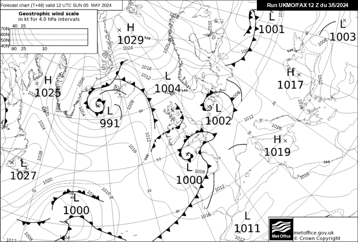
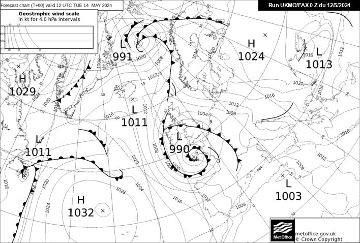
Fax charts are out:
http://www.meteociel.fr/ukmo/fax/fax48s.gif < @ 48h
You can see the low here- SE flow with a warm front pushing into the SW, followed very closely by a cold front behind it.
http://www.meteociel.fr/ukmo/fax/fax60s.gif < @ 60h
Cold front catches up with the warm front and forms an occluded front heading for us.
Looks good for Snow on the fax charts
Take a closer look at the fax charts, whirling around that low is a wind pushing behind from the adlantic turning the winds to a NE directly from the sea. as it hooks round. If it snows it wont snow once thats passed over.
-
What is the Adlantic (sic) you keep talking about?
You have been calling this for a few days, if we do get the GFS scenario over the next few days, then I will say well done, but it hasn't happened yet.
Please dont think im crazy, but this has proven to work for me many many times. I print the charts out, and I use a pendulum to give me some signs on whats likely to happen to systems that are in place. I guess in many ways this is no differant to trying to apply maths to a system that has no constant (Equations) so far my pendulum is about 80% accurate.
Feb is looking intresting however, so watch this space. The adlantic is only going to win for a short time. Something is going to happen over the northen hemisphere thats going to drag more cold over much of the north. When those charts start to show in FL I give you what I think then.
This is how I picture you:
The picture didnt show, if its an insult thats probably a good thing, smug laminate floor lols. Not being smug just dont be so quick peeps to dissmiss what I say next time


Wales Cymru Cold Spell Discussion
in Spring Weather Discussion
Posted
Where is this heavy stuff comming from as I canot see it on the radar.