


LincolnSnowstorm
-
Posts
531 -
Joined
-
Last visited
Content Type
Forums
Blogs
Gallery
Events
Learn About Weather and Meteorology
Community guides
Posts posted by LincolnSnowstorm
-
-
-
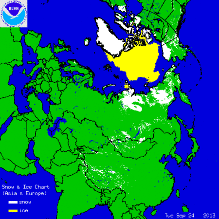
The blob grows!

-
 1
1
-
-
That first link is a thing of real BEAUTY.
http://sveaspitzbergen.livecam360.com/flash/main.php http://portlongyear.livecam360.com/flash/main.php
Then I guess these won't look too bad added to a few peeps browser bookmark list .
-
2
-
-
Looks pretty dark for midday too !!
Thats because its a bit cloudy today, there was some weak sunshine lunch time yesterday on the archive.
It will be turning to the dark side soon tho....Sunset 10 to 4 local time today and 16 days before the sun no longer rises! http://www.sunrisesunsetmap.com/ssmap/year.php?lat=78.2161023779328&lon=15.69671630859375&tz=UTC&year=2013
-
Hey guys, just thought I would do an October animation of snow and ice build up. Here's the 1st to the 8th.
Unusual big and early, that was impressive.
-
Just realized there are parking lots for snowmobiles at longyearbyen! zoom in http://longyearbyen.livecam360.net/
Guess there is a point of time when most of the chunky 4x4's get put away for the winter.
-10deg C and snow forecast Saturday morning. http://www.yr.no/place/Norway/Svalbard/Longyearbyen/long.html
closer look at the snow getting closer to Scani
-
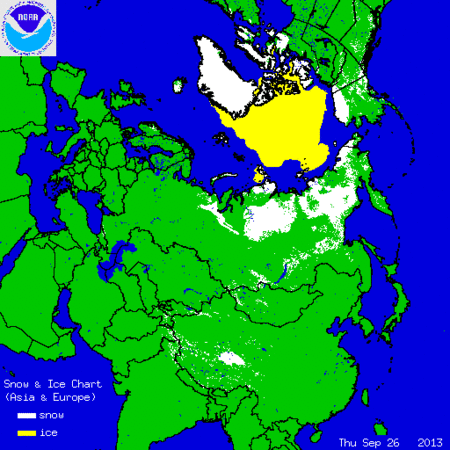
more Ice joins up with russia another box ticked!
-
4
-
-
Monday.... Turkey gets snow and the ice appears to melt! strange.
-
3
-
-
Looks like the first proper dumping of snow in the USA, the rockies and the Northern Plain states of Nebraska and South/North Dakota covered.
Some interesting reports http://www.ktvu.com/news/news/snow-buries-central-states-storms-threaten-midwest/nbGLM/
-
This to show the recent snow build up.
Zoom ctrl + http://gickr.com/results3/anim_4c5d65c4-59b1-8b44-21c1-60343863b15e.gif
Generally red negatives to the north blue to the south but Russia is now so snowy its now losing that feature on the 4th October chart.
-
The impressive snow growth keeps going for now
http://gickr.com/results3/anim_ede4e81a-97f8-6fc4-092b-d8ef961d684b.gif zoom ctrl +
Hockey stick http://www.natice.noaa.gov/ims/images/ims_data.jpg
-
1
-
-
Tempted to look into the background of this anomaly chart a little more, it's interesting because the -ve anomalies are in the places which would normally get the snow earliest close to the Arctic Ocean. It's almost as though there is enough warmth from the ice-free sea surface to reduce the coastal Arctic snow for the moment, whilst the extra moisture enhances the snow further inland to the south.
Looks like there is even more contrast now between those two areas , so I will find it interesting checking to see how long this theme will keep going. It tends to always be changing week to week so time will tell.
-
Positive gains http://www.youtube.com/watch?v=-MrxA1KXWJk but also a growing amount of red negative anomaly in places
blue or red which will win this October?! -
A review of the current sunspot situation.
Astro Nomer;
"Sunspots? Did someone just say sunspots? Hang on... can't ... quite ... see ... any... erhm, No wait, there's one, a tiny one, but it is one!"
Mill Keyway;
"Are you sure? I can't see a damn thing!"
if you zoom in real close you can make them look big!
-
My thinking on the above issue of Scandinavian snow cover is that it would show a nice closer to home progression but its too extreme a wish for september at least in any significant amounts.
But give it a couple of weeks or so and maybe it could change to look more like 2003 in that area
Things looking very steady for the last two days on the snow and ice chart http://gickr.com/results3/anim_870ad8b6-80bd-5714-1559-51832e964de7.gif
-
-
For those that just want to see the growth in snow , we are up to 345,456 snowmen already
thats fantastic news! when they all each have less than a square km of ice to stand on then we'll know we are really cooking on gas
-
..and the prettiest september snowy scene award goes to......Svalbard
-
1
-
-
More signs of the Autumn arriving white paint gets spilt more in cold weather.
http://weatherspark.com/averages/33843/Norilsk-Taymyr-Autonomous-Okrug-Russian-Federation
-
29th Oct. 2008 is my marker .. more snow here than at anytime last winter ! I note in my diary I called it 'my polar low' .. having forecast snow that October and declared the 'end of global warming ' a fortnight earlier.
I see what you mean
then later on -
1
-
-
You compare 22 nd of october with 7& 8 october, that's a difference of 2 weeks. That's a lot in this situation. When you take a look at the daily departure chart, you'll notice big blue areas. Indicating a positive anomaly. This is the situation of yesterday.
my reply was to put a picture on the comment 'it looks like early October' So you sound like you would agree with me that it looks good but not that good.
-
I've not read the paper but i do recall somebody saying that it mentioned longitudinal extent being an important factor so presumably we want snow as close to Europe as possible by months end.
24 October 2010 showing the way it should be done....as much as possible as close as possible.
-
2
-
-
Looks more like early October?
How will we achieve our rapid October snow build up if we have already a high values in September?
Here's what early October (end of first week) looks like, often a lot more snow cover compared to today so its pretty normal at this time. (room for improvement)
http://gickr.com/results3/anim_b78621b6-ca3b-a394-25c7-65cac75561d0.gifpoint barrow looking fab and proper wintery earlier today, the temps there have dived recently
-
2
-
-
You might want to add this to your favourites, the Icelandic Met Office site, always worth a look for snow junkies.
Tom.
thanks tom , I see it also does earthquakes reports so I can keep an eye out for dodgy volcanoes http://en.vedur.is/#tab=skjalftar
http://www.livefromiceland.is/webcams/katla/ http://www.jonfr.com/volcano/
-
3
-


Snow and Ice in the Northern Hemisphere 2013/14
in Spring Weather Discussion
Posted · Edited by LincolnSnowstorm
Your welcome.
Heres one more link from the area http://kappamsterdam.livecam360.com/flash/main.php
and these could look cool latter in the year. Thank you livecam360 for hosting these links for us to see
http://www.livecam360.com/webcams-360/6/suisse/
http://www.livecam360.com/webcams-360/5/allemagne-autriche/
http://www.livecam360.com/webcams-360/1/montagne/
http://www.livecam360.com/webcams-360/2/ville/
http://www.livecam360.com/webcams-360/3/mer/
http://www.livecam360.com/webcams-360/4/campagne/
http://flycam.skyviewlive.fi/
Favs anyone?