


Sainsbo
-
Posts
1,191 -
Joined
-
Last visited
Content Type
Forums
Blogs
Gallery
Events
Learn About Weather and Meteorology
Community guides
Posts posted by Sainsbo
-
-
Looking a bit rough on Satellite imagery now, but nonetheless I wasn't expecting to be posting in an Atlantic Hurricane thread in january this year!

Despite the SST's being only in the low 20's - which is usually too low to aid tropical cyclone development, it looks like unusually cold air in the upper troposphere provided some more favourable conditions for this to take place.
It didn't look bad for a weak Cat.1 either, to think sometimes we are months into the hurricane season before we see a storm with a eye that's defined enough to see on visible imagery
-
 2
2
-
-
4 hours ago, *Sub*Zero* said:
And is also picking up on the small low running NE across Ireland, it could certainly pack a punch if it comes off... Is that 150km/h gusts into SW Ireland?
Let's hope the ECM, and more patricularly the ARPEGE are wrong about this secondary low, the presure gradent is extremely tight.
-
2
-
-
Black areas showing wind gusts of over 150kmh^-1 (93mph), with the entire purple area ahowing gust speeds of over 80mph. Let's home we see some downgrades as we're starting to get closer to the reliable timeframe
Don't be fooled by the fact the centre of the low is only at 975hPa - There's still a 50hPa pressure gradient from NW Ireland to SE England!
-
10 hours ago, BornFromTheVoid said:
Ah yes, climate change is a grand global conspiracy where 10s of thousands of scientists spend years in training and research in order gain the ability to manipulate climate and weather records - all to pursue their master plan of punishing the poor, destroying economies and helping to instill a one world communist government. Totally sane, sound and logical that.
I'm sure in many decades people will look back and wonder why more of us didn't come to such an obvious conclusion, and why only the extreme right wing media, extreme right wing politicians and brave, laissez-faire free market bloggers had the brains to get together will the fossil fuel industry and expose climate change for the massive hoax it is!
It's completely baffling, looks like I'm gonna be handing out tinfoil hats at Christmas this year.
The fact they've managed to make an agreement on the first place in the aim to limit warming to 1.5C is a milestone in itself. I don't think we'll manage to do it, but the fact they're trying is a fantastic start (better late than never, I guess)
-
3
-
-
It really doesn't seem like the media are picking up on the seriousness of the situation - 12 hours of very heavy rain still to come when flood defenses are already close to failing. Let's hope the people of cumbria are heeding the advice of the Met Office.
-
1
-
-
As a first year Met student myself, I'd definitely recommend "Fundamentals of Weather & Climate, 2nd editon", by Robin Mcllveen. It gives a pretty good overview of the most important aspects, and while I haven't read all (or even most!) of it yet, it doesn't seem to be too maths heavy.
http://www.amazon.co.uk/Fundamentals-Weather-Climate-Robin-McIlveen/dp/0199215421
-
1
-
-
Jesus Christ
Sustained winds of 200mph makes this the strongest storm worldwide since the beginning of the satellite era. Raw T numbers of T8.3 are being recorded, which is off the scale. Not only that, but the NHC suggest more strengthening is likely. I didn't think we'd see something stronger than Haiyan for a long time..
A beast in every way possible. This will be catastrophic
-
3
-
-
Rain may be a very very big problem for the Philippines in the next few days, GFS output had a max of 79 inches for some locations!
-
1
-
-
The situation is so volatile that I really don't think it's even worth looking at the models past 48 hours. How long is stalls over the Bahamas, and how sharp the north turn is will greatly effect it's path later down the line, and so far none of the models are consistent even with their prevoius runs, let along each other.
Looks like it's still strengthening though, the eye seems to be warming up a little
-
Recon has just found FL winds of 130kts, looks like it might already be a catgory three.. Not good news.
Some ADT values here, though they aren't of much use in the Atlantic when we have regular recons
http://www.ssd.noaa.gov/PS/TROP/DATA/2015/adt/text/11L-list.txt
-
1
-
-
Big westward shift in the NHC advisory, now expecting a category 2 landfall over Chesapeake
-
Euro still doesn't want to play nice with the other models. Still showing Joaquim recurving back out to sea..
-
HWRF and GFDL still giving quite extreme solutions, 80+kts slamming into the NY area. Still plenty of time to change, but definitely one to keep an eye on. It looks as if the rapid intensification may have already started.
18z predicted intensities:
The NHC still have the warning cone way out to sea, let's hope that they are right on this one!
-
Still looking like a possibility, but as it is still 5-6 days away, anything could happen.
-
The last run of the GFDL-P has a Cat 4 hitting the Carolinas, GEM has a weak TS hitting Florida. Still all kinds of possibilities being forecast by different models.
-
Still lots of uncertainty regarding the track and intensity. HWRF has a FISH finishing the run at around 125mph/950mb, and as SS said, the GDFL makes Erika into a monster, peaking at around 150mph/938mb. CMC on the other hand has Erika making landfall as a weak category 1. Everything else seems to be between the two extremes
-
As long as Metcheck don't get it I'm not too worried
-
1
-
-
Lightning strikes ever second or two, literally! Storm approaching from the south, thunder rumbling in the distance is starting to become more pronounced, and looks like it's heading this way too!
-
I'm liking our chances of some action later in our neck of the woods, let's hope we get lucky,
-
2
-
-
Definitely wasn't expecting it to be quite this hot!
Wonder if we'll hit 37C, or is that just being greedy?
This also makes it the joint 3rd hottest day in the UK ever
-
BBC forecasting 36C for London and Heathrow now!
-
Might have been rounded up, the Met Office are saying 32.5C at Heathrow. But still, that's crazy!
Already broken into the top 100 hottest days on record, joint 95th
-
32C at Heathrow at 9:50
-
1
-
-
Caught 3 buses today - 3:50 PM, 5PM and 23:00PM. The first two were so hot I had to get off early and walk! maxed out at about 28C here today according to the official station, though, my own station recorded 31C


Atlantic Storms Winter 2015/16
in Storms & Severe Weather
Posted · Edited by Sainsbo
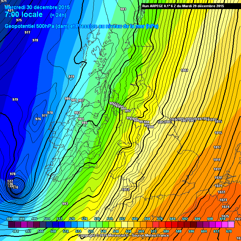
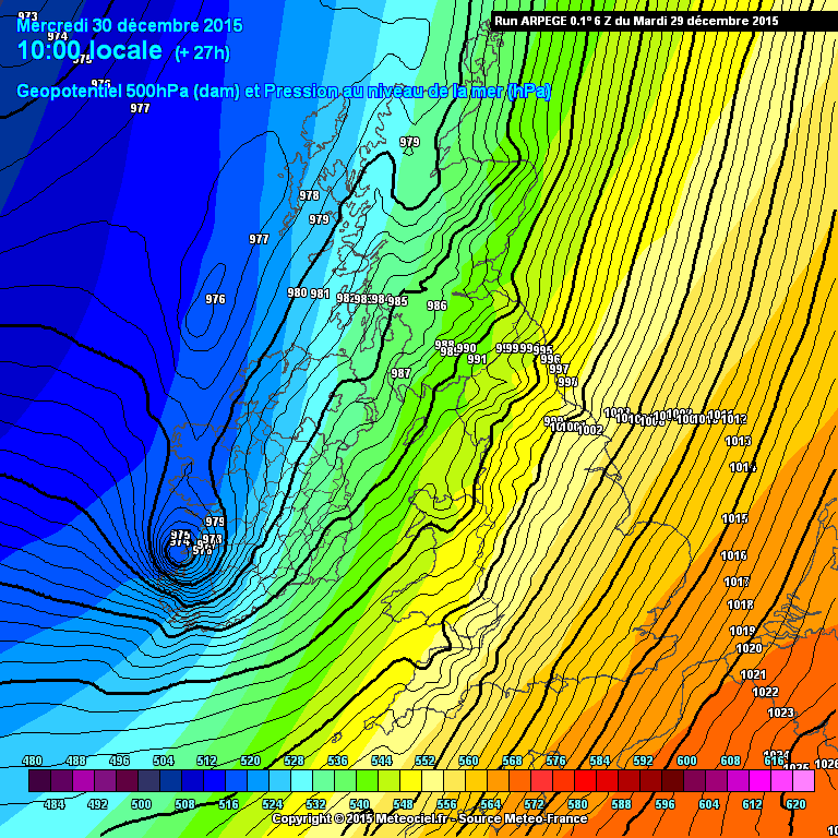
ARPEGE has gone a little crazy on the 12z, has a very small but extremely severe low passing over the north of Scotland tomorrow night.
Very tightly packed isobars. Not sure how much confidence people put in the ARPEGE, but showing gusts of 180km h^-1 over scotland - That translates to 110mph. 125mph off the west coast.
Luckily no support from the NMM or GFS for anything like this, just thought it was interesting as I can't remember ever seeing 200kmh^-1 being predicted by any model for somewhere near the UK
Edit: The HIRLAM 12z shows a similar feature, albeit a bit weaker.