


Allseasons-Si
-
Posts
12,112 -
Joined
-
Last visited
-
Days Won
61
Content Type
Forums
Blogs
Gallery
Events
Learn About Weather and Meteorology
Community guides
Posts posted by Allseasons-Si
-
-
6 hours ago, matty40s said:
I don't think they will have time,that is of course that the eruption takes place just north of Grindavik
the gps is on the threshold now nearly matching the previous eruption back on the 18th Dec.
 Near Real Time 8 Hour Time Series
STROKKUR.RAUNVIS.HI.IS
Near Real Time 8 Hour Time Series
STROKKUR.RAUNVIS.HI.IS-
 1
1
-
-
4 minutes ago, Cheshire Freeze said:
The issue being that where we were orginally seeing solidly -AO charts being churned out, we’re now seeing strengthening TPV.
This is due to the failed reversal IMO. So we are seemingly reliant on Atlantic sector amplification…which really isn’t ideal to hang your hat on.
Would this not take into effect until a couple of weeks as the landing date for the near reversal is the 6th Jan?
don't shoot me Aaron as i am not that clued up about up above so just asking

-
 4
4
-
 1
1
-
-
9 minutes ago, MJB said:
Control is shaping up nicely
Yes it is a nice chart because it has lower height's under the high to prop the high up,watch for heights to migrate west once the split flow opens up to our west in the Atlantic,seen that modelled a few times
-
2
-
-
I think peeps are throwing there toy's out of the pram too early,it's still an evolving situation here
chins up guys

-
6
-
-
OK guy's let's keep it friendly in here please,do remember this is a public forum that anyone can read
please keep it model thread related with some backup as to what you are explaining with a bit more info,one liners/moaning and off topic post's will get moved or removed
there is a moans thread,there is a meto thread and a historic thread of which you all know about
thank you.
-
7
-
1
-
-
I think everyone has had too many sherry's cos as far as i am concerned the charts was showing height's past day ten if memory serves but now we are seeing this been brought forward before day ten as in heights starting to build in the Atlantic,no model is going to nail a day ten chart just yet so sit tight and see how the next few days pan's out
don't forget that the 12z has been a good upgrade today so don't let one chart (aka the pub run) spoil your evening when it doesn't show what you want it to show
it does have better amp than the 12z as i stated in my post^^ but goes teet's up,...IN FL but hey that's just that fl.
-
4
-
-
- Popular Post
- Popular Post
Aaannnddd!! ,...what's wrong with this...
clearly the height's are pushing further north than the 12z,people just don't let the models roll out before commenting on then.
18z v's 12z.
and just to add,it has a better vertical WAA N profile than the 12z NE profile.
-
10
-
- Popular Post
- Popular Post
Hey gang,...not been on today as i have been busy with stuff but it's nice to see upgrades in the models
and finally we are starting to see some of the mild outliers getting ironed out on the ens
ECM 12z v's 00z
gefs 12z v's 00z
cracking set of means at day ten too
De-built NE'ly's are increasing to 66% from two day's ago
my optimism has crept up slight today so my glass is half full but not full yet and i just hope that we can get enough amplitude to this high propped up by lower height's to our south
on to the 18z we go
-
15
-
1
-
18 hours ago, Derbyshire_snow said:
Have you got a link?
The link is above that i posted^^
-
Swings on roundabouts really when it comes to the models,the 18z control run has an amplified run similar to the 12z op then the 18z op similar to the 12z control
this tells me that the models don't have a scooby on what is going on past day 6>,it all boils down to how the phasing of the lows out of the NE states behave at that said time
the 18z control does not phase with the downstream trough and it stays seperate and heads E/SE whereas the 18z op phases the low with the downstream trough and sends it NE
so lots to keep tabs on over the coming days
I know which one i would back but the gefs isn't that bad really
day ten...
-
6
-
-
No more off topic post's in here ,if you like to moan about what the models show,...head over here.
and please don't respond to off topic post's otherwise these post's will get removed too,thank you.
-
1
-
-
Just now, feb1991blizzard said:
oh no - sorry - thought there was one for both - cant see one, there definitely used to be.
I am sure there was one too before that meteocial breakdown,...what caused that again?
thanks for the EPS mean one's though
-
3 minutes ago, feb1991blizzard said:
WWW.METEOCIEL.FR
Meteociel propose le modèle deterministe dehttps://www.meteociel.fr/modeles/ecmwf.php?jour=27&mois=12&annee=2023&heure=0&archive=1&mode=1&ech=72&map=0&type=1¶=0 ECMWF CEPIs there one for the gefs?,i can't see one?
-
1
-
-
2 minutes ago, feb1991blizzard said:
yes there is.
Well that is something that i didn't know TBF so you learn something new in here,...so point me in the right direct Feb
-
1
-
-
- Popular Post
- Popular Post
2 hours ago, johncam said:This is the model thread or is it not? and that is the mean at the end , it heads in the wrong direction
2 hours ago, johncam said:But when other posters post a mean that far out that is showing cold that is ok we can't be selective, that's what it shows
Sorry for the confusion and the debates about the mean charts at day 16 and you are quite right to post it in here but just make sure that you put some more info into your post stating what your chart/s shows,the point i was trying to say to you earlier is that there is so much happening well before the16 days mean chart that there is so many scenario's that may happen that it skews the mean chart because there are different paths on the ens(not the same as the ops) that these will or could take and so then we would look for trends this far out,i hope that helps
i too also post mean charts and we all do it to see if there is a change in them within 24 hrs for better or for worse
sadly we can't compare mean charts from the day before because there isn't an archive for those(not on meteocial anyway) to compare unless you save them to your device
anyway,...talking about mean charts,the EPS is pretty good,the gefs not so good
EPS v's gefs 12z,obviously i would like the EPS to be correct here but we need some support from the gefs
and the cpc backs up the EPS in regards to +ve heights in the Atlantic and has not changed from last evening
the NAO/AO still in a neg phase so all is good at the moment.
-
14
-
3 minutes ago, johncam said:
I am sorry John but you just cannot post a mean chart 16 days away and expect that that will be the outcome when there is so much happening just 6-7 days away
-
9
-
-
3 minutes ago, mountain shadow said:
Ah, the old UK high, great news for the Greeks, boring for us.
I hope that is not where we finish up
I would certainly take it as second best from all this wind and rain,...besides there is still a lot to be resolved yet
-
8
-
1
-
-
1 minute ago, That ECM said:
Not saying you are wrong but why?
It will be after this point that the height rises take hold
-
3
-
-
7 minutes ago, DCee said:
UK high pressure illustrated again.
With the energy to the East, the cold will slide into Europe and beyond.
This feels like a likely outcome given where we are. Good thing is the HP will be quite sunny and mild, very few frosts in the SE.
Certainly not mild when you have -digit numbers across the country,if you have high preasure over the UK you will have inverted cold as in colder air condenses and decends in the center due to slack winds.
-
8
-
-
UKMO 168
i wouldn't at all be surprised that this would back west somewhat,then we would be in the game,looks very slidey,more twist's and turns to come i think.
-
4
-
-
A better 12z so far with little pocket's of height's to our NE forcing the jet ever so slightly further southeast with each run,subtile changes with make bigger impact as to where we are heading,...hopefully a good heading
-
7
-
-
1 minute ago, Polar Maritime said:
We can certainly see that jet slowly sinking south on each run..
Yep,thanks to a better amplified ridge in the Atlantic
-
4
-
-
- Popular Post
- Popular Post
We don't want to keep on deleting post's peeps so just think about what you are about to post,and do not respond to off topic post's
keep it friendly,...thank you
-
10
-
1
-
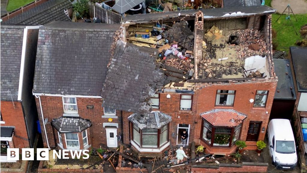
Storm Gerrit: Roofs blown off as tornado strikes Stalybridge
WWW.BBC.CO.UK
Roofs are torn off houses, trees fall and walls collapse in part of Greater Manchester during Storm Gerrit.-
1
-


.png.f87dd145a8b24643e9f81b585197cd8b.png)

.png.bf5d85ca3fc4f91487a3ca01d995657c.png)
.png.759df24c656675cc2b1ce634ade37b9b.png)


Model Output Discussion - Into Winter
in Forecast Model Discussion
Posted
The gfs at 168 is very clean with the WAA tip of Greenland,should force that Icelandic low south.