


Snowman.
-
Posts
3,375 -
Joined
-
Last visited
Content Type
Forums
Blogs
Gallery
Events
Learn About Weather and Meteorology
Community guides
Posts posted by Snowman.
-
-
could someone -plz tell me last winter when the block finally affected our weather in some way in february was it in early feb or later i cant remember the right time period.
Around the 1st 3rd was when had snow I think?
-
So this nicely ties in with GP's forecast of a potential bitter 2nd half of January then?
I wouldn't say secound half of January atm its looking too see most a January blocked just depends which half actually delivers.
-
just a crumb of comfort- 3 days ago, the models showed us 'winter wonderland'. now they show 'a bit nippy'. the GFS goes out to 16 days showing atlantic domination. what will they show in another 3 days? or 3 days after that? what we seem to have learned is that 16 days is way too long to even look for trends! in just 3 days time we could be waxing sledges again. or not.... who knows really? its still only the start of winter
ikr What is the point of the models when all it needs to forecast is shortwaves to ruin everything and delay us even more for a successful cold spell!
-
Will the ECM kill at least half the people on this forum?
-
Nice touch might as well just say this.
PESKY SHORTWAVES!!
-
While cold, very cold air slides it's way across Eastern England early next week, yes we may end up with a narrow northerly with a slight NNE slant, but this is still a great scenario for us. The cold air will be frigid, and with a relatively warm north sea, we will end up with showers of snow, and longer spells at that in a gentle breeze that will feel perishing for our little Island.
Lots want the easterly of all easterlies, but if we can just have patience, I am very confident personally a easterly will evolve and we get what we want. ANYTHING from the east will do! The air mass there is going to be so, so cold, it will do!
I personally believe NE Scotland, NE England E Anglia will do very well out of this, also Kent and eastern parts of Suffolk, Essex etc. I know getting specific is dangerous and can cause disruption litterally to this forum, it's my belief, and can be taken with a very tiny pinch of salt.
We need to get real anyway, were heading for a very cold spell, and the threat of snow! Which is just brilliant this early.
I feel comforted with this as a NE usually effects the eastern coast and leaves me alone but this usually evolves into a easterly anyway but It might take sometime for that but I reckon come new year we will have a look a simple fresh easterly!
-
If that low went through the channel we could be put straight into a freezer!
-
Well the ECM looks less colder the yesterdays but a whole lot more snowier in a balanced perspective!
-
Eyes down for the newest ECM what's your predictions!
-
What is wrong with this chart?
It's V FI wouldn't even happen but look at the central point of that low and pressure the is just SCREAMING mild, wet and zonal winds!
That wouldn't happen but it just really horrible to see!
-
I would like to say that CFS picked this up a while ago and it seemed to materialize I would start to look to the CFS for similar trends it may not be good at closer range but its a very useful model as its TWO colder trends that its picked and actually pulled through!
-
GEM is a real upgrade from the previous run, but going for a northerly instead?
-
No need for anyone to get down about the GFS run today look what we had last year at this time,
1 year ago today flat as a pancake

1 year later today much better with potential,
Our outlook today for mid December,
And our dire outlook for mid December last year,
I'm not complaining about this year at all!
I have already had snow may have been 3cm so no complaining at all.
-
I already miss this chart!
ECM soon lets see if we can hit gold again!
-
Looks fine from where i'm 'sitting'!
Nothing wrong with it until latter it wins and stuff but that too far ahead right now!
-
Then again it all goes t*ts up!
-
Look who decided to show up?
Atlantic trying to push but I wouldn't worry about it as it doesn't look it will get that far east with that angle.
-
I reckon the 18z GFS run will be a more diluted run of the ECM.
-
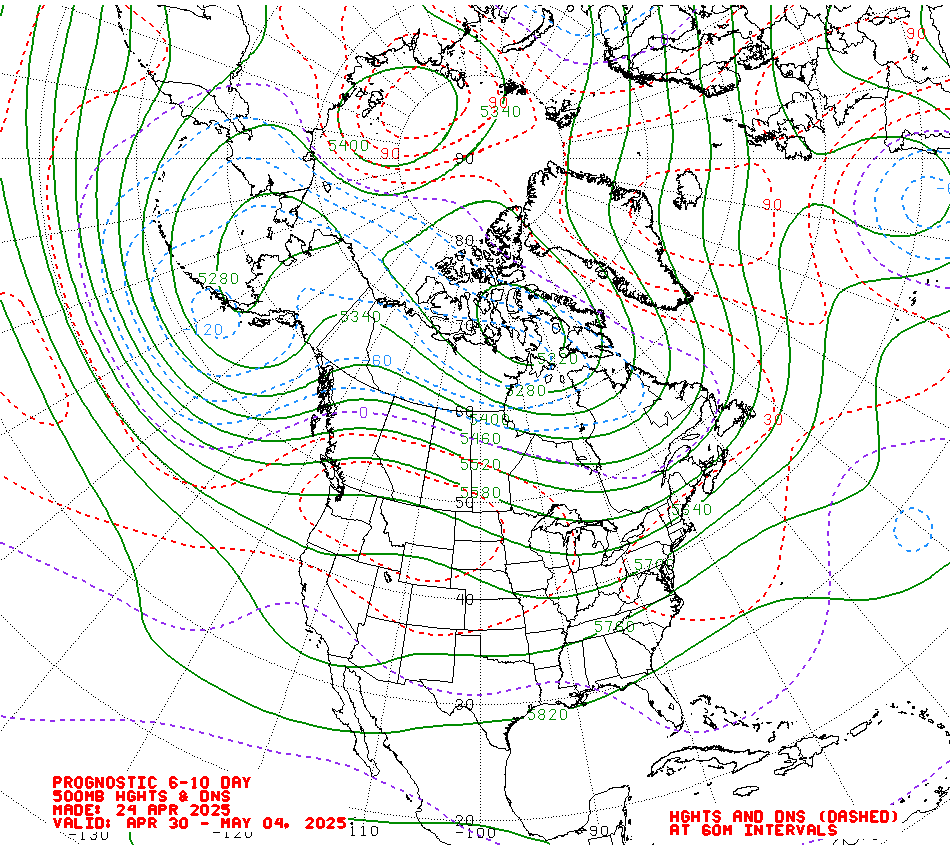
Chiono the CPC charts look in line with retrogression:
Wouldn't surprise me with that kind of blocking it's going to need to go somewhere!
-
Different towards the end sends the low south rather north looks better for snow but NOT sustained cold,
-
Best run so far everything seems further north with low pressure close delivering snow in the SE, FI yes but still.
-
-
Wait their is a dent over Iceland!
-
No shortwave above the High looking god guys!


Model Output Discussion - 8th December Onwards
in Forecast Model Discussion
Posted
Greenland ridge is much stronger I wonder if its enough to send it far enough south?