


Snowman.
-
Posts
3,375 -
Joined
-
Last visited
Content Type
Forums
Blogs
Gallery
Events
Learn About Weather and Meteorology
Community guides
Posts posted by Snowman.
-
-
Not sure what to say looks good for FI but it just getting pushed further back?

EDIT: NVM Looks good
-
That trough is causing all the problems although it looks as if pressure is trying to build behind it.
-
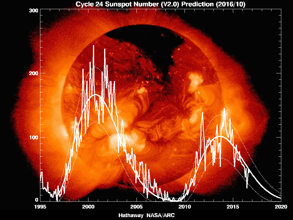
Not sure what effect sunspots have on the coming Winter, but it's certainly beginning to ramp up a little
Solar maximum not a rare site plus the lag effect which a year or so but for solar maximum it's still low though.
http://solarscience....n_predict_l.gif
Compare it too 2000.
-
Ohhhh this looks gooooood.
http://www.cpc.ncep....a/nao.sprd2.gif
And
http://www.cpc.ncep....ex/ao.sprd2.gif
If we do get some cold it should be fairly decent!
-
The CFS ensemble forecast anomalies for the end of November/start of December showing
blocking to our North-West once again after a few wobbles over the last week.
Chart flipped round to show it from "our" perspective.
To far west for my liking but anyway the future is looking alot more interesting at the moment with all this potential, fun times are ahead in terms of the models.
-
Why do you say that, how is that going to progress into anything other than a Westerly flow of some sort ?
From that link I see the PV looking likely to split meaning that their would be a change in weather pattern as height increases over Greenland.
-
No, it would appear you're looking through cold-tinted glasses. The NAO forecast is not 'neutral at best', on the first graph* all members point to a moderately positive outcome for the next week, later trending towards neutral but with just four of them opting for varying degrees of -NAO.
Further down the line, that can of course all change - EML isn't suggesting that November mildness (which earlier you were denying as being likely!) guarantees any sort of weather further down the line. It's rather the stratosphere's November weather, rather than the UK's weather, which is (strongly) indicative of the UK's weather further down the line, though of course still doesn't give anything close to definite.
*I've never paid attention to the three graphs below, no matter what they're showing. What exactly is the difference between them and the top graph, and why are they showing fairly different outcomes?
edit: I do think there's a tendency in this forum to jump on anyone who suggests/points out the possibility of mildness, as if they're suggesting mildness will reign for months and months or as if they're suggesting it's a definite outcome rather than a possibility.
Actually that looks better than yesterday in turns of cold, only one run went negative on that chart is looks like there flipping to a negative so I don't think that you can through that away just yet out of the 3 months of winter it has time to change as it just goes out to a 14 day period.
-
so GP, are you saying we could have a winter like 62/63 influenced by the stratosphere?
Wow that escalated quickly!
-
 1
1
-
-
Yep.. not a lot to inspire us at the moment, was trying some reverse psychology.. iirc - Think Matt said the ECM 32 final long term out look was due on the 8th. Reminds me of a post from the AmWx thread.
What's the Strat Doing?.... it's all cold and Vortexy.
It looks like it's trying warm up a tad but I suspect it usually does this...
-
Can we please stop with the *insert weather type* is due theories please. There is no such thing as something being due, the probability of something does not increase because it's not happened in a while, if that was so then we'd be due a '63 type winter by that logic, but we're not.
Shhhhh
Have you not seen the topic title?
-
The quasi cool zonal mix of October looks like extending to the end of November. The 0z today is much of the same right through to the end of its run. Variance from yesterday's runs are that HP is less progressive than trough activity, vice versa yesterday.
Temps, average to cool with dry periods between the rain, that is after this relatively dry working week.
In fact, although yesterday was disappointing, today's appears to have no Scandi blocking at all and it is apparent that the westerly flow of these lows, simply push the Atlantic highs east into Siberia/Russia territory, with not even a passing shot at Scandinavia; a further step back from recent runs. So not a hint of cold on this run.
http://cdn.nwstatic....384/npsh500.png
The above is the PV at the end of FI, still flabby, but any cold progged to spill into North America and Siberia. So there remains potential for change to favour the UK, but as ever just as much chance that it will miss us, despite the good synoptics reviewed by the experts on here.
The ensembles go out to 22 Nov and show a mean in Aberdeenshire around 0c for much of FI (T850s):
http://cdn.nwstatic....erdeenshire.png
No real cold options in there at all, cool at best.
As with last year, all can change, but it does appear that we are stuck in this pattern and GFS are giving little indication of a change to colder (or milder) weather.
Hmm I can see the next 10-14 days being fairly settled but look at that chart -10 to 7 which doesn't suggest a very accurate answer now I'm not clinging onto now straws yet but the possibility of a cold flow at the end of November to December is looking likely especially if that PV decides to move again as it can't seem to settle down anywhere. I believe that this winter will be cool much like we have experienced already but with some periods of Southerly flow bringing so mild and wet conditions in the west I also believe will see record heat/rainfalls maybe even some gale force winds recorded along with some record cold/snow (not as bad as 2010 don't worry) so all in all two extremes in one winter which tbh I wouldn't mind.
-
I must say though that the PV doesn't look like its going to stay over greenland that long
-
I'm new to the Stratosphere and stuff like that so don't shout at me! I am slowly learning by looking through your posts and data that you provide I have a question about the polar vortex. What makes the vortex stressed and doesn't settle in particular spot moving around the northern pole and making all weather patterns act weird.
-
nice looking northerly - for next weekend - so the slightly milder blip this week won't be lasting too long
Ahhh you beat me to it!
Now lets see if that Trough will play ball.
-
There seems to have been a real shift in recent days to the erosion of Blocking taking place and latest runs for next 16 days seem to be firming up on a more Westerly flow with pressure seeming to fall up in Greenland so i think chances of Blocking are dropping daily.With the Azores High never being too far away either it isn't looking that great for cold and snow lovers.Hopefully,things will change but the odds i feel of a cold start to December are reducing imo.Just hope we don't have repeat of last winter when only cold we had was last few days of Jan and first 10 days of Feb(And we were luckier than most here in Kent in the UK!)Still time for things to change but "my gut" feeling is that if there is to be a sustained period of cold in the UK,then it will be from Jan onwards.
PV heads over Greenland that is why pressure drops but considering that thing has been everywhere I wouldn't suspect it to last there that long.
-
2012 - Winter was spring, spring was summer, summer was autumn, autumn is winter..........WINTER=1962/63
Or winter is 2011 Spring
-
Evening All-
We are entering a period of high model uncertainty & large scale corrections westwards in the outputs-
This is a typical signal when the models are trying to resolve a block to the east. In These situations I dont really have a strong preference to one particular model, however the GFS is generally always to far east & the 18z & 06z are almost worthless - with these runs always moving to an overunning pattern post 180- with no undercut.
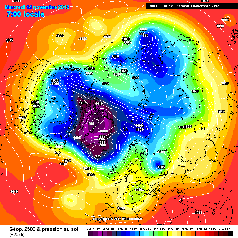
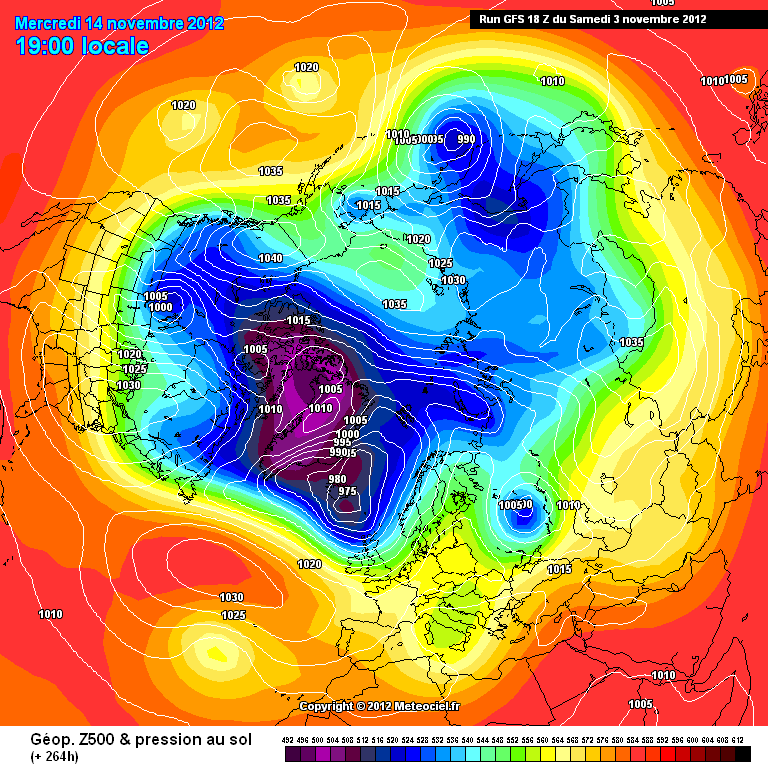
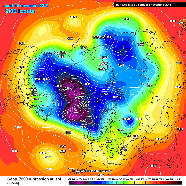
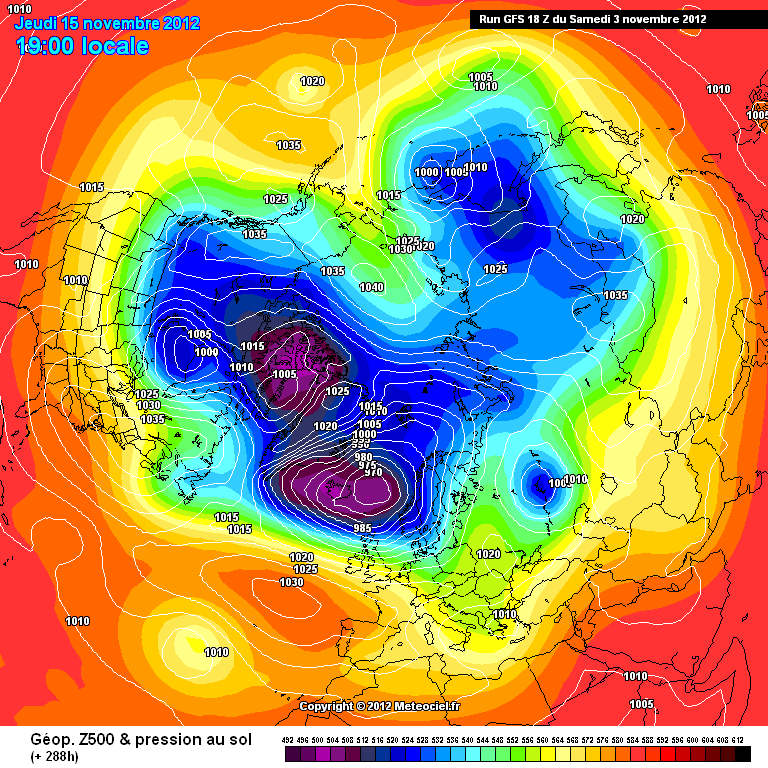
Heres a typical example of the GFS moving all jet energy into the northern flank & forcing the whole pattern to overun any blocking to the east-
http://modeles.meteo...nh-0-216.png?18
http://modeles.meteo...nh-0-228.png?18
http://modeles.meteo...nh-0-240.png?18
http://modeles.meteo...nh-0-252.png?18
http://modeles.meteo...nh-0-264.png?18
http://modeles.meteo...nh-0-276.png?18
http://modeles.meteo...nh-0-288.png?18
Note the GFS is sweeping that blocking away by having the energy piled up on the NW flank.
As we go through the runs over the next 48 / 72 hours expect some wild swings in FI from the GFS, but after this period the models should have a grip on what pressure build there will be over Scandi.-
The touted Northerly may develop or it may be forced back West as the low pressure gets split & energy heads down to the canaries...!!!
I guess the bit that needs to be highlighted is its still november & the continent wont be mega cold- we are at that tipping point where a gentle continental flow wont be very cold or mild, so will just feel slightly cooler than seasonal- all the while the CET ticking along generally below average.
I think we have all been spoilt by some recent synoptics & events happening in some recent years in the early part of the season-
Its the 3rd of November & expectations shouldnt be to high at this stage- Winter still isnt going to switch on all of a sudden, its a slow burner for the next 10- 20 days.
I for one am very satisfied that the mean zonal wind is being broken down to a negative anomaly, & the storm track is highly amplified.
as result of that the departure from the Norm is sitting around 1-2c, as a result pro rata come december we should be forecasting a CET of around 2.5-3c...
Exciting times, just patience required- the PV isnt suddenly going to explode into life- there is a lot feedback in the troposphere this season that seems to be propergating upwards - acting as some form of compensator against the ever cooling stratosphere.-
Anyway-
Expect further changes west over night- all for the good.-
S
I know this is a long way off but the 18z GFS has the PV pushed east over Canada allowing heights to rise over Greenland yet again.
So far off in weather terms but still hope is hope. Looking at the NAO forecast the Atlantic is still pretty much dead might rise to positive before going into the the negatives. Shame that I cant say that about the AO any reason why this is?
-
no you right it feels like weve skipped a few weeks if that makes sense
Yes it feels winter already slightly odd feeling actually.
-
Well here goes nothing! My winter "forecast"
November - I do believe this month will be slightly below average with a milder setting half way between the month but it wont last long as I believe we may get a taste of winter with temps dropping across the UK with frost likely where skies are clear may have showers running down the north and east coast to lower levels at time it may well accumulate over time I can see these heading further depends on the balance of the could/wind direction this will continue into the first few days of December.
December - Not sure about this one I do believe this one will come out average as mild air sweeps through It will remain like this for most of the month as fronts push east. Towards the Christmas period I think we could see temps decline a little bit with high pressure in full control with a deep frost were skies are clear cant rule out a shower run down the coast these are most likely to be wintry even at lower ground. As new year comes I reckon we could see a easterly start to develop but not in full swing till January.
My beginning of winter forecast this just based on pure feeling so don't take it into assumption.
-
what chats are they then? there is nothing interesting in the charts for next week, aka the reliable time frame whatsoever
sure the ECM in FI looks good from a NH point of view but the actual weather for our tiny island will be average to mild if those charts came off, im afraid
too many on here harp on about a displaced vortex but until we actually benefit from it with good synoptics then it don't matter really does it,
if the ECM went on after 240 what would happen ? the mid atlantic ridge would collapse into us i presume
and by the way i don't like to be patronized as you think im a new member, i was here before under a different name, and albeit i am no expert, i am not exactly a complete novice either and can read the charts
anyway still plenty of time, i just think a few on here get a bit over excited too often
Its only next week I couldn't care less if November is mild and wet as long as I get a week with a couple inches of snow and some cold within the next 4 months I'm happy!
-
All fun and games from the CFS this far out so nothing should be taken from it but look at that low as it heads into Ireland.
Powerful stuff!
-
CFS daily is all fun and games if your low on hopes that might cheers you up blocked for a 2 weeks!
Makes a different approach with the High that the GFS just hasn't got a scooby what to with it.
-
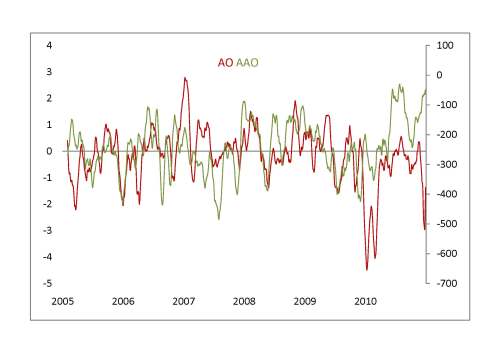
Is there any relation between AO and AAO (Antarctic Oscillation)?
Current AO
http://www.cpc.ncep....ex/ao.sprd2.gif
Current AAO
http://www.cpc.ncep....o/aao.sprd2.gif
previous years
Well
Their goes my hope for November!
-
I would rather see cold for late Nov to early Jan, similar to 2010-2011
Tbh Essex missed most of the snow in December 4" max one good snowfall? November was about double that or more which is always good. February this year was a decent snowfall just didn't stick around long enough. I remember the 09/10 winter being my favourite winter of all as January never let me down with snow showers in February every week or so never go old!


Model Output Discussion 13/11/12 18Z onwards
in Forecast Model Discussion
Posted
Not bad run real potential for something longer lived that High looks to be in charge and would take some force to move it the size of that thing is massive!