


Tom D
-
Posts
1,346 -
Joined
-
Last visited
Content Type
Forums
Blogs
Gallery
Events
Learn About Weather and Meteorology
Community guides
Posts posted by Tom D
-
-
http://www.meteociel.fr/modeles/gefs_cartes.php?code=21&ech=144&mode=0&carte=
06z ensembles are IMO very good. About half of the 20 peturbations send the energy SE at or around t+144. There are 3 or 4 others that are not far from doing the same, and then the remaining 6 or 7 show the kind of Atlantic breakthrough that both the operational and control and indeed the ops of both the UKMO and ECM show at around +144.
Peturbations 2, 3, 6, 9, 10, 15, 18 and 20 are all great or close to being so.
The mean, linked above, doesn't really justify any comments that the cold spell is definitely going to end either. I may end up eating my words later...
-
i personally cant see feb being a cold month until the battered vortex stays weakened or relocates more to a favourable area.....
Nobody can, especially when we still have so much chopping and changing this week ahead. The trend is for less cold conditions by the weekend but it's by no means a formality - when we've seen how a 1016mb high pressure can influence the path of low pressure systems over the past week I wouldn't bet on any of the current outcomes coming to fruition.
The FAX 84hr shows another potential snow event for the south on Wednesday.
Honestly sometimes I wonder what will make people happy in winter - by next Friday most of the country will have had cold conditions for nearly two weeks and many have had snow, some of it very deep. From an IMBY perspective it's not been the deepest snow but it has been consistently snowing, I think 5 days of the past week have had some snow and there's going to be a couple more days this week.

-
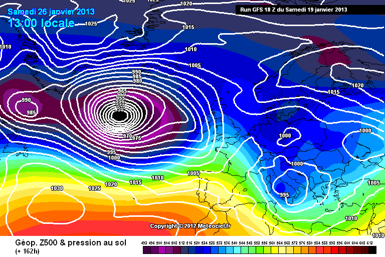
http://modeles.meteo...fs-0-162.png?18
Forget the kitchen sink... I think the Atlantic is about to throw the entire showroom at us at +162.
The Atlantic is pretty pi**ed off:
One word... encouraging.
-
What a difference 6 hours makes.
-
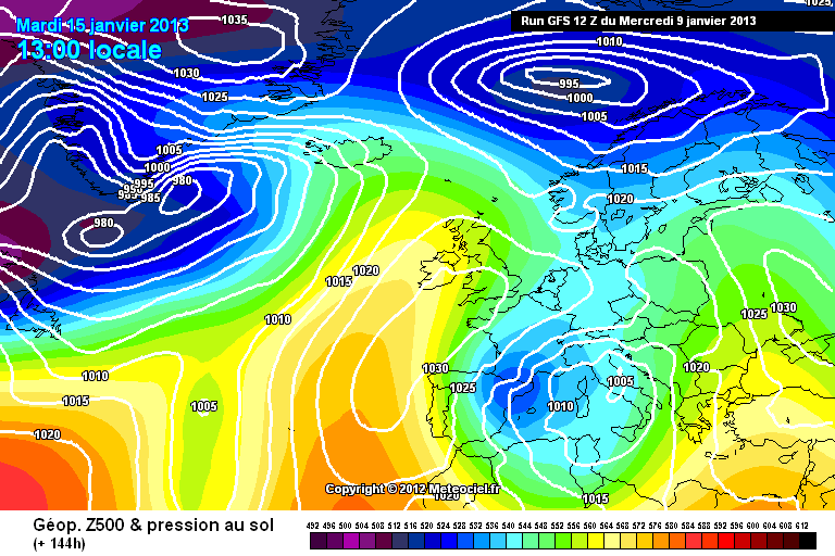
Well the GEM 12z looks like holding on to the cold for longer and even given that it stands alone I still wouldn't write off our chances
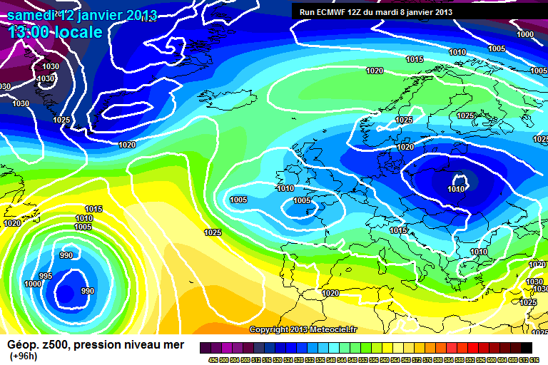
GEM very similar to ECM at t+96, t+120.
+96
http://www.meteociel...CM1-96.GIF?19-0
http://176.31.229.22...12/gem-0-96.png
+120
http://www.meteociel...M1-120.GIF?19-0
http://176.31.229.22...2/gem-0-120.png
Albeit the GEM is better for Scandinavian heights.
EDIT: Oh dear. http://www.meteociel.fr/modeles/ecmwf/archives/2013011912/ECM1-144.GIF
-
6z shows even with less cold T850's, temps only a fraction above freezing at the surface thanks to the widespread snowcover across many parts of the uk by then, the coldest uppers across the far northeast, an area in the uk which has missed the fun so far.
http://91.121.16.5/modeles_gfs/runs/2013011906/84-778.GIF?19-6
http://91.121.16.5/modeles_gfs/runs/2013011906/84-7.GIF?19-6
I think the uppers look better on the meteociel charts. You can still see quite widespread -2 to -4 and with ground temperatures of -1 to 1c there won't be much time for snow to melt on it's way down.
Sorry for south bias of those charts but it's out of my control.
-
http://www.meteociel.fr/ukmo/archives/2013011900/UW144-21.GIF
http://www.meteociel.fr/modeles/ecmwf/archives/2013011900/ECM1-144.GIF
http://176.31.229.228/modeles/gfs/archives/2013011900/gfs-0-144.png
Well I never. ECM and UKMO move towards the GFS solution past t+144 now, but rather than the mild conditions the 12z showed it appears that, especially in the south, conditions will attempt to get back to normal - albeit with a struggle after such a lengthy cold period.
-
Schizophrenic GFS 18z. These synoptics looks rather odd... it's as if it wants to bring mild but it being forced against its own will to back down.
-
Is that not a 'dead' front? Note how the semi-circles and triangles are not filled with black.Nice trough coming over central England tomorrow, that should give a few more surprises?
-
The good thing is that the ECM and UKMO are largely similar at t+144, which bodes well considering how the ECM pans out afterwards. GFS on its own, shame the GEM has botched up on meteociel.
http://www.meteociel.fr/modeles/ecmwf/archives/2013011812/ECM1-144.GIF
http://www.meteociel.fr/ukmo/archives/2013011812/UW144-21.GIF
-
-
It would be unwise to rule out the GFS completely. There is clearly something to suggest a change to less cold weather and we may see the ECM/UKMO etc start to show a slightly less progressive version of what the GFS is currently showing. We will eventually inevitably see a change to less cold/average conditions. GFS may have just got in a few days too early and too severely.
-
De ja vue.
Can anyone explain why the Scandinavian high somewhat falls away between +120 and +168?
Afterwards it builds again as seen in my first link.
-
well i for one find this chart rather odd as everyone else has snowfall over most of the southern half of the uk.
Remember that these models are programmed to expect snow given certain conditions. Human logic can better these models by taking into account other factors like dew points, ground temps, 2m temps and such.
http://www.meteociel...tions-hd/3h.htm I think this shows it better (although I apologise that it only covers the southern UK). This also shows how the precipitation weakens as it moves nearer the block.
-
hi i'm still learning how to read models, but where on monday would the snow affect if indeed it does arrive?im in south east wales and am wondering what parts of the country will be affected as im working in the midlands monday and need to travel there and back!
Impossible to say for sure. Wait for Met Office warnings. They're paid professionals at what they do.
-
Absolutely superb ECM t+168 to +192 this morning.
http://www.meteociel...1-168.GIF?16-12
http://www.meteociel...1-192.GIF?16-12
Very interesting potential on Friday for significant snow for much of England and Scotland. Pinpointing the details probably won't be possible until the precipitation appears on the radar such is the nature of weather fronts hitting a block.
GEFS not quite so intent on building heights over Iceland like the ECM does and there's a huge spread for Oslo.
http://cdn.nwstatic.co.uk/ensimages/ens.20130116/00/prmslReyjavic.png
http://cdn.nwstatic.co.uk/ensimages/ens.20130116/00/prmslOslo.png
-
Dear oh dear oh me. I mostly enjoy watching the discussion but this ECM is fantastic for cold. If this verifies we're in for a deep freeze. Exciting territory and potential. A few weeks ago we'd nearly written off this winter!
-
I don't often like to be OTT but my word that is an extreme chart which would cause absolute chaos.
http://www.meteociel...M1-168.GIF?10-0
JMA on board with a cold E,ly.
Think of the instability. ECM stands for European Cold Machine right?
GEFS peturbation 2, 3, 4, 7 show potential for undercutting low just to give an impression of how it may pan out.
-
No haha. The GFS could still prove to be right, although it's now looking unlikely that the 6-7 milder runs will prove correct. Yet again it's GFS vs UKMO & ECM.
It's still just as likely that the GFS has picked up on the right signal as the ECM/UKMO/GEM. They may also be extremes and we'll see a half-way house scenario unfold. Still, the similarities and the consistency between the ECM 0z and 12z is positive. The battle continues.
-
The award for Best Run goes to the ECM this evening. A stunning turn of events after +120, but it remains that the shortwaves moving from Greenland that are still causing model and forecasting uncertainty.
Neither the operational or control build heights from our western Euro high up to Greenland after +120, whereas the UKMO is very progressive at doing so. The ECM sees a short link-up at +120 but after this the SW Greenland low squeezes beneath what is a rather shallow high, but I think this is a finer detail at this range.
In any case we've got a good prospect within 96 hours for snow and I'm glad model watching has become more entertaining again.
EDIT: Additionally, the potential for the shortwave at +120 to drop south a la ECM/GEM is very exciting; leads to a lovely potential for the Scandi block.
-
Interestingly the GEFS control is very similar to the UKMO up to around t+108 hours, before we see the importance of a link up between the Iberian high and the Greenland high for preventing the Atlantic breaking through and upsetting everyone.
GEFS control t+96 http://modeles.meteo...s-0-1-96.png?12
UKMO t+96 http://www.meteociel...96-21.GIF?08-18
Please note the short wave over S Greenland, which is more pronounced in the ECM operational at t+96
ECM t+96 http://www.meteociel...812/ECM1-96.GIF
By t+144 we see how important that is with regards to the link-up of the aforementioned highs.
GEFS control t+144 http://modeles.meteo...-0-1-144.png?12
UKMO t+144 http://www.meteociel...44-21.GIF?08-18
That doesn't mean to say it's not been a great set of 12z runs but it's far from a smooth ride from here.
-
Having been invited to do some 'Cold Hunting' - here's my best catch of tonight's models. 600-768 hours away.
Eye candy.
-
I hope I am wrong, but the closer we get to this cold spell, the more I am just not seeing where any precipitation is going to come from, I guess it's a long way off just yet, but you have to admit that there doesn't look to be very much in the way of it for the vast majority away from the East Coasts, it would be the ultimate disaster if we found ourselves under -8 uppers , but with naff all in the way of precipitation ...maybe I am worrying about nothing ??
This happens every time - you can't look at precipitation in detail with this setup beyond 24 hours, and I'm sure members will back me up here. I remember February 2010, with a mega Thames streamer when we got 18cm here - largely unforecast until the day.
-
Lovely snow here in Ware - http://i.imgur.com/4Mc57.jpg


Winter Model Discussion 18Z 19/1/13 onwards.
in Spring Weather Discussion
Posted · Edited by Tom D
Cross-model agreement between GFS, UKMO and ECM at +120. GFS holds the low pressure off more at +144, but it would still be less cold. Confidence of a breakdown is increasing.
http://www.meteociel...M1-216.GIF?20-0
http://www.meteociel...H1-240.GIF?20-0
EDIT: Horrible. Horrible. Horrible. Is there anything positive we can get from these charts?