


mb018538
-
Posts
7,447 -
Joined
-
Last visited
-
Days Won
11
Content Type
Forums
Blogs
Gallery
Events
Learn About Weather and Meteorology
Community guides
Posts posted by mb018538
-
-
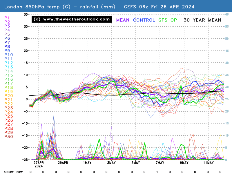
Indeed ti does, but it is one of the warmest 2/3 ensemble members: http://www.theweatheroutlook.com/charts/gefs/gefsens850London0.png
There are many more clustered between 5-10c at 850hpa, so at the moment I guess we should favour that. It doesn't detract from the fact that there is still a very marked improvement shown around the end end of the month on both the extended GFS and ECM runs this morning. As it gets a day closer, we should hopefully bemore confident that it is the right picture being painted!
-
Any weather from that NW quadrant will remain on the cool side with those pesky low SSTs lingering on from that brutal winter and spring in the eastern USA. Until the flow is purely WSW or better, 850s will be on the low side. Hopefully it can pull East in time and tap back into the very warm/hot continental air
-
Back to tonights 12z runs.....the UKMO 144 is a shocker for July! Dartboard low plonked right on top of the UK. Expect plenty of rain there to go with the other systm moving in Friday-Saturday. http://www.wetterzentrale.de/wz/pics/Rukm1441.gif
I think we can write the rest of July off now as a bit of a disaster. A fair amount of rain, wind and temps around or slightly below average. Disappointing considering how hot the beginning was, and how hot a fair portion of western Europe has been this summer. So near yet so far.
We now turn our attention to the beginning of August for our next hope, as others have said. Signals showing a drop in heights over Greenland, as well as different, shifting patterns globally which should help break this cycle to something a bit more settled and summery. Keep your eyes peeled! -
I think totals here in cambridge were 120mm widely, with some places locally between 150-200mm....it's taken me 8 hours to get the school I work at in some sort of state to be open. I'll post some pics up later and a video of that massive hail.
-
Oh my god, think this is the back of the storm front, but I've never never in my 30 years on this planet seen hail, lightning, thunder and wind from a storm like this. Cambridge by the way. We've had 3 hours of intense storms followed by 30 mins of something that'd wouldn't be amiss in the Midwest in the USA. I'd be very surprised if there's no damage or flooding in the morning. Simply incredible.
-
 3
3
-
-
Torrential now, storm directly overhead. Wasn't expecting anything this severe despite the warnings from ESTOFEX! I'll just stand window watch I guess!
-
1
-
-
Plenty of activity here in Cambridge, cloud-ground strikes, increasingly heavy rain too. Looks like we got lucky and are right in the firing line today!
-
6z is certainly better than the 0z run, and as stodge points out above, with a trend back towards a more positive NAO, hopefully we can finally see some lower pressure back to our north, and an end to NW'erly quadrant winds.
I know this isn't necessarily going to lead to some blowtorch heat, but :
http://www.wetterzentrale.de/pics/archive/ra/1990/Rrea00119900803.gif 3rd August 1990
and
http://www.wetterzentrale.de/pics/archive/ra/2003/Rrea00120030810.gif 10th August 2003
and
http://www.wetterzentrale.de/pics/archive/ra/2006/Rrea00120060725.gif July 2006
These hot weather spells all had generally lower pressure to the north. It can only be a good start!
-
The amount of high pressure and blocking over Greenland and the NP this summer has been unbelievable!
I truly believe that without the remnants of Tropical Storm Bill that threw a massive wave into the jet stream and gave us that incredible heat earlier in July, this summer would have been devoid of anything extreme heat-wise.
Going forward the models don't appear to show any break to this rinse and repeat pattern of brief heat pulses clipping the SE, while the NW stays cooler and more unsettled. Typical summer weather I guess. We can all just wait until winter returns, when there is sure to be no sign of any height rises over Greenland or the pole, with a big fat ridging Azores high and a long train of atlantic depressions giving us windy and mild weather.-
3
-


Model Output Discussion - 1st July Onwards 18z--->
in Forecast Model Discussion
Posted
Yes desperate ECM tonight, which rather than erodes the Greenland block, builds it up to 1040mb! If things follow this pattern, we could be seriously running out of time for some real heat!