
- Popular Post


MattTarrant
-
Posts
427 -
Joined
-
Last visited
Content Type
Forums
Blogs
Gallery
Events
Learn About Weather and Meteorology
Community guides
Posts posted by MattTarrant
-
-
12 minutes ago, abbie123 said:
Lots of copping and changes to come will this come of no one knows yet but if it does this could bring blizzard to the south east england and southern England and then pushing to other parts of uk let's see where we are at the weekend with this trends.

That is an 0z chart but yes it would, what I like from the 6z development is that the Azores high is displaced out into the Atlantic allowing low heights to remain across Southern Europe. It would be even better if the high could just ridge a little up towards Greenland.
Jet Stream backs the continuation of the feed of low heights into Southern Europe
-
 1
1
-
-
We have some lying snow here, mostly on cars & patchy on grass. 2.5 degrees.
-
1
-
-
Very minor covering up on dartmoor....
-
1
-
-
A link here to Haytor weather station here! Temperature there is dropping rapidly! 1.5 degrees. (450 metre altitude).
http://www.lyneside.demon.co.uk/Haytor/automatic/Current_Vantage_Pro.htm
-
1
-
-
3 minutes ago, Nights King said:
Not liking that..
2 minutes ago, AWD said:If that's what you have forecast up there, then what hope do I have down here. Lol
*cough*cough* look ahead!!
-
3 minutes ago, khodds said:
Someone keep me updated on the MAD thread today please.. I darent go in! Plus I'm at work.. it's easier to listen to you lovely people
I just went in there, now i believe we are a week from a heatwave
-
1
-
-
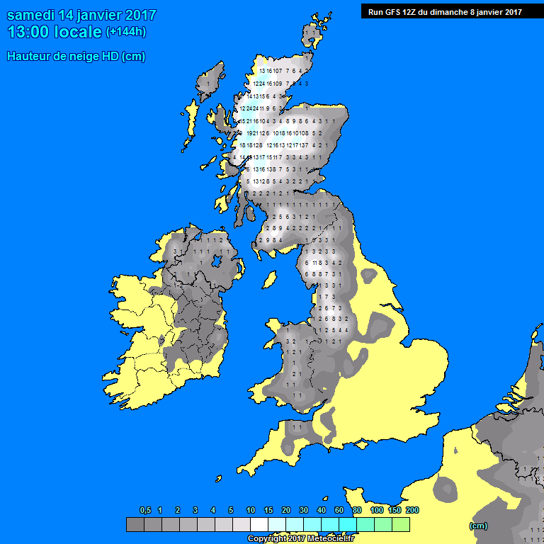
5 minutes ago, Summer Sun said:
Not to be taken as a given of course as snow could fall just about anywhere later this week this is the peak of the snow accumulation on this run from GFS
Yesterday for comparison
Both charts up to Saturday 13:00
Very true, though if you consider the Met Office Yellow warning of snow that stretches into the South West suggests that 2-5 cm of snow could fall even at lower levels. The above charts suggest otherwise, i would go with the Met office(UKMO).
Plus the GFS has a more North Westerly component to it which hinders snow potential in the south west, UKMO more Northerly.
-
Just now, Richard Fisher said:
Mostly snowless for the majority of Southern England though from that chart.
Yes true, but the UKMO run is looking a little better in dragging the colder air down quicker than the GFS 12z. Though i wouldn't trust a GFS Precipitation chart if it was 3 days away!
-
1
-
-
2 minutes ago, radiohead said:
Low pressure sneaks in from the Atlantic at T168 bringing a mild sector and rain. Snow on northern edge.
However, when the low clears it does once again draw in colder air!
-
1
-
-
2 minutes ago, abbie123 said:
Looking cold with some snow showers in the north maybe some pushing south on this chart..but no big freeze yet and sustained colder weather but it could change..
Yes no big freeze, but as ever the cold spell could increase or reduce by a day depending on the extent of ridging in the Atlantic. I would expect a 2-3 day period from current runs.
-
2
-
-
Just thought i would post this as its a very good tool. The new Metcheck Super Ensemble. The attached chart is for my home town of Tiverton (61m).
Some good agreement now with only three runs from the 60 runs showing positive 850mb temps. I would approximately say that 60/70% show around the -4/-5 mark with around 7 or so showing -9/-10
-
4
-
-
Just a quick showcase of how much the orientation of the high makes so much difference to the 'prospects'. Much more amplified on the 12z
6z 228h Vs 12z 222h
-
7
-
-
4 minutes ago, tight isobar said:
A decent 'northern hemispherical' profile.
The azores sore thumb getting squashed out...and seeping upstream towards eastern seaboard. .something of an evolution we need to see lot's more of throughout raw output.
I was thinking the same thing though there is still too much energy coming of the Eastern seaboard for it to have the potential to form a more robust block.
It's once again quite a potent PM incursion (Excluding the South West of course
)
-
1
-
-
The high pressure does seem to have retrogressed somewhat more than the 6z run which is good to see(I only got to quickly look at the 6z this morning so sorry if i'm wrong).
The North Westerly (PM) incursion is already evident as incoming around 156h
-
1
-
-
GFS 12z does begin to push increasing heights out of NE America around 198h which by 210h push up towards the Arctic. Hopefully this continues in the next runs.
-
7 minutes ago, bluearmy said:
The GFS 06z was in line with the ECM is having the lower heights south of the blocking by day 9/10 and therefore putting less forcing on the Atlantic ridge. the 12z is mor GFS ish in placing too much energy into the northern arm which collapses the ridge east but it seems that promotes a decent chance of an easterly anyway. could be in of those win win periods of model watching coming in in th mid term before a shortwave pops is in a few days to scupper the whole thing!
I have to agree completely with you on that one. The GFS doing its usual 'spinning up mega low pressures' thing by the end of the run. Still that Northerly is quite potent! *Note the Northerly I mention is nothing to do with the chart!
-
1
-
-
The Rivers around here are getting seriously high, just about to exceed Sunday Morning's heights. The River Exe was getting relatively close to the underside of one of the 'tall' bridges.
-
3 minutes ago, TropicThunder said:
The lightning rates on that Dorset/Wilts storm are insane, must be similar to the Bournemouth storm last year. Just shows that when conditions are right even this country can put on a good show.
Yes these storms are quite small but wow they kicking out the lightning strikes at the moment!! #Saints4ever
-
1
-
-
1 minute ago, Flash bang flash bang etc said:
Has someone poured crack-cocaine into the North Sea?
Maybe some fell of that boat caught near Aberdeen!
-
Just now, ajpoolshark said:
just got back from a jaunt around Northants/Warwickshire and the Cotswolds....some showery rain to report via some elevated stuff but nothing to write home about....Back home now waiting in hope to see if anything comes up from Biscay......Feeling like a sauna outside with air temp of 23C with dewpoints around a zillion degrees.....lol
There was some decent convection which led to elevated rain but its like it just couldn't tap into the energy! Air seems fairly clear with a few breaks developing now!
-
Brightning up nicely here with temperatures rising steadily! A few rumbles would be nice later this afternoon!!
-
11 minutes ago, ajpoolshark said:
strikes now being detected moving NNE off the NW French coast into the southern English Channel associated with a big mass of convective rain tracking NNE out of Biscay.....anyone from east Devon to IOW should keep an eye on the sky in a few hours time as the plume is starting to destabilise
I am keeping an eye on the sky haha, though I would never judge what is going to happen with the weather on the BBC precipitation graphics, on there latest video the precipitation has pushed further west and is likely to affect most of Devon. Here's hoping!!
-
1
-
-
20 minutes ago, Supacell said:
It's on topic as far as I can see... a video of a thunderstorm, and a fantastic one at that. As you say it is hard to believe this was England. I've never seen CG's raining down that frequently in this country. I know that night was an impressive night though, especially across the south coast. I am thinking it is the 4th July last year as at the end of the video there are links to other videos for this date.
If I see something even close to that tomorrow night I will be forever satisfied!
Even a small thunderstorm would go down a treat here! It does look like I am on the western fringe of activity but i'm staying positive!!
-
Excellent weather here this morning, supplying plenty of surface heating with temperatures already rising nicely!! Could do with a few thunderstorms as have missed the majority of them this year. Wind convergence looks most likely to help storms here because CAPE is relatively low, wind is almost non existent so storms could cause some local flash flooding.
-
1
-


 )
)


Model output discussion 25th Jan - The final third of winter beckons..
in Forecast Model Discussion
Posted
A little chilly next Saturday....