


Grimers
-
Posts
184 -
Joined
-
Last visited
Content Type
Forums
Blogs
Gallery
Events
Learn About Weather and Meteorology
Community guides
Posts posted by Grimers
-
-
3 minutes ago, Nick L said:
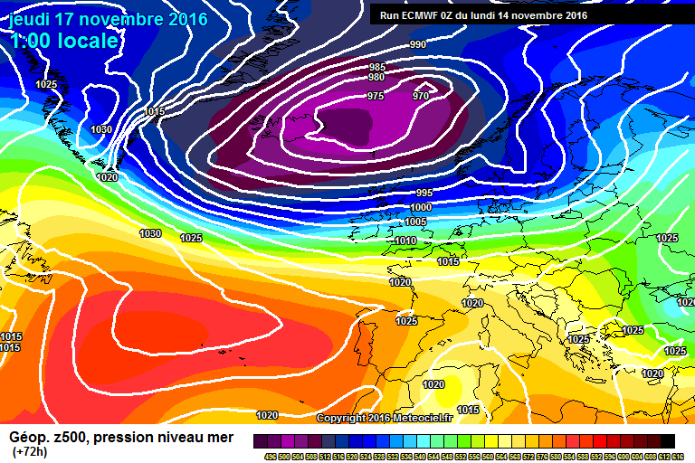
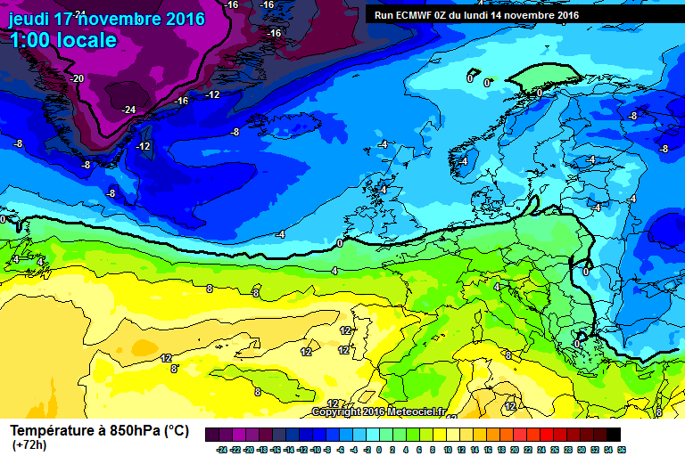
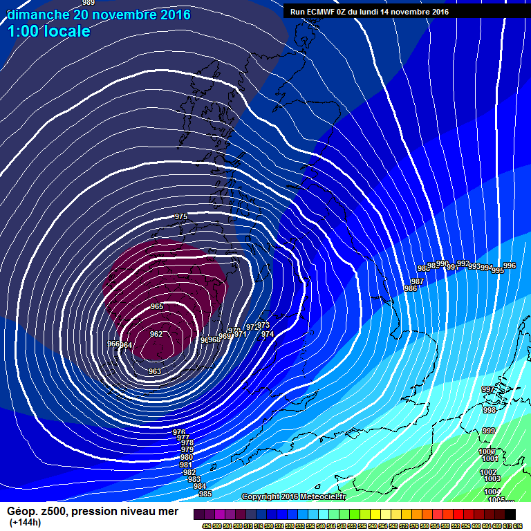
The EC really ramps up this storm for Sunday, 80-90mph gusts through the channel! Interestingly would dump a hell of a lot of snow over the Welsh mountains.
Is this using a detailed model that's available to the public?
-
11 minutes ago, Nick L said:
Wouldn't even call it a storm on that, max gusts on the GFS are generally 35-40mph.
EC however does ramp it up with 60mph gusts quite widely.
Yes, hence why I said potential, and as the UKMO model has already developed the low, it could potentially develop further.
-
Just now, SN0WM4N said:
GFS and UKMO at 144
GFS
 UKMO
UKMO
Yes, as I said above, they're starting to agree, this could be a nasty storm...
-
The UKMO model is now picking up the idea from the GFS model of a potential storm on Sunday.
-
 2
2
-
-
Just now, Daniel* said:
Honey G sort of music?
I think some folk are getting ahead of theirselves and in all likelihood may end up getting disappointed. I think it's rather clear by now we're not going to see any deep cold in November. The charts above are flat and mobile, wet and cool, which has characterised a string of winters which we daren't speak of, I'm not quite sure what you're seeing - do not associate blues with cold especially with maritime sourced winds which offer very little, it's going to be a long winter, some composure is needed?
I'm not getting ahead of myself, neither am I excited, I'm just describing what the charts show.
-
2
-
-
1 minute ago, CreweCold said:
As I said earlier, Will, The Jan-Mar anomalies for pressure look to me to be signalling the potential for a snow maker of a battleground between colder continental air and Atlantic LP systems. Just has that look.
Yes, I forgot about that. I think this is going to be a very interesting Winter.
-
2
-
-
3 minutes ago, fergieweather said:
Yes, it's been the similarities between ECMWF and GloSea 500hPa GPH and MSLP anomalies that grab the eye foremost (GloSea's respective ENS mean fields and +ve anomaly probabilities below).
Looking at this output, especially noting the lower than average pressure over the Atlantic, could mean a higher likelihood of snow events from Atlantic fronts rather than off the continent? This is just a theory which may suggest heavy but rare snow events.
-
5
-
-
According to the ECMWF model, it's music to the ears for cold lovers.
-
2
-
-
Just now, Nick L said:
When "drier than average" is indicated, it will mean all precipitation types.
Understood!
-
11 minutes ago, stodge said:
Afternoon all
Fascinating update from Ian as always (for which many thanks). I'm beginning to wonder if this may be a winter for fans of cold rather than for fans of snow.
Blocked anticyclonic conditions in midwinter can easily deliver ice days under inversion - lingering mist/fog can easily keep even London close to or below freezing - and it doesn't matter if there isn't a huge cold pool source to tap into.
I'm wondering if we may be due something we've not been for a fair while - cold winter anticyclonic conditions, no snow, but plenty of cold.
I'm pretty sure you get snow at least once with any cold Winter... But, yes it's looking that way seen as the predictions are for a drier than average Winter, but what we mustn't forget is even though drier than average conditions look likely, that doesn't mean there will be less snow, it normally means there will be less rain.
-
3 minutes ago, Summer Sun said:
ens mean maps have updated
Dec to Feb high pressure looks centered over Scandinavia
Last months update
The 850 hpa temp is above average
Rainfall looks close to or slightly below average
You couldn't really ask for anything better for cold lovers!
-
4
-
-
According to the UKMO model, there's a possibility of a weak arctic blast on Friday.
-
9 minutes ago, ajpoolshark said:
it's quite interesting actually as a couple of days or so ago, the GFS picked up on a signal for a quite southerly tracking low to wizz through with potential for gales, heavy rain and dare I say it 'the white stuff' for the same time period.....one to watch
Yes, if that low took a more southerly track it could bring a widespread snow event to high and possibly low ground.
-
1
-
-
1 minute ago, Tim Bland said:
Very "Bland" output there. no real signal either way. roughly 40-60% Mild, 20-40% Average, 20-40% cold.
Basically, if the output is right, we're looking either at a slightly milder than average, average or slightly cooler than average Winter.
-
-
According to the ECMWF model, there's a possibility of a severe storm bringing severe gale force SW winds to SW parts of the UK, which would be perfect for my Davis Vantage Pro2!
-
3
-
-
2 minutes ago, Mark N said:
Cold Northerly to end on the GFS 6Z Control run.
That looks similar to 6 years ago...
-
1
-
-
4 minutes ago, weirpig said:
Im a bit confused bt that is the last figure the daytime temps and the first night time?
Correct.
-
5 minutes ago, vizzy2004 said:
For some reason its not letting me post charts on here
Try posting charts from http://www.meteociel.fr.
-
1
-
-
3 minutes ago, weirpig said:
maybe not cold for our little isle yet. But look at scandi again they are having a very cold start to the season.
Yes! The amount of blocking that's already in place is a good sign for us!
-
1
-
-
Just now, Ali1977 said:
Can't post picture but at day 9 we have gone from a low pressure in NE Canada to a high pressure - just proves where we are with regards FI!!!
Although, this FI could be a good one as the PV over Greenland moves East it may give us a long drawn Northerly flow and a big Block to our NW - maybe!!
Agreed, when colder conditions are forecast FI can be earlier than average.
-
- Popular Post
- Popular Post
According to the GFS model, it's looking good for cold lovers on Friday!
-
13
-
Yeah, I'd love to help!
-
1
-
-
I understand, but we are all well aware of the guy wires and stakes to hold them in place, we have had guy wires break before but that's because they were old, the ones I've installed recently are much stronger and are 3 mm thick.


Model Output Discussions 06z 04/11/16
in Forecast Model Discussion
Posted
Ok, is that model available to the public?