


Barmada_Casten
-
Posts
250 -
Joined
-
Last visited
Content Type
Forums
Blogs
Gallery
Events
Learn About Weather and Meteorology
Community guides
Posts posted by Barmada_Casten
-
-
Just now, Chill Pill said:
I do feel very sad for you ?
I know people think I am a troll but I will try and put a photo on showing my depth levels. I am in a part of north Devon that has missed out, and it's the only part of the whole of the south west!
-
Just now, benricky said:
You have to be a troll or the most unlucky guy on the planet haha
I have been accused of being a troll but I'm am being honest. I am in south west england right now and have seen a dusting of snow!
-
1 minute ago, Spurry said:
We should start a group for depressed people who live in snowless areas
Plenty of people will be laughing at me in here I know I am not popular in the slightest. Today should have been a nailed on epic. All around me talks of 39 cm depths and I have a dusting. Struggling to come to terms with this.
-
Well guys you couldn't make it up. I am in south west England right now, in north Devon. A day of snowstorms was forecasted for today and tonight. They missed my location and I am in the only part of Devon that has no accumulations of snow. to the the south east and west of me there are talks of accumulations of up to 30cm, I genuinely have got a dusting. Snow set to hit tonight looks like it will miss me. Words fail me since there are no words which can describe how sad, lonely and gut-wrenched I feel right now. Starting to wonder if my life is destained to be a total failure.
-
It looks like that band over the channel is disaperating and isn't even on course to hit me here in north Devon! A dusting of snow for me today. I am beyond words, no words can describe how terrible, sad and gut wrenched I feel right now.
-
41 minutes ago, Bring Back1962-63 said:
Don't worry. here's an update:
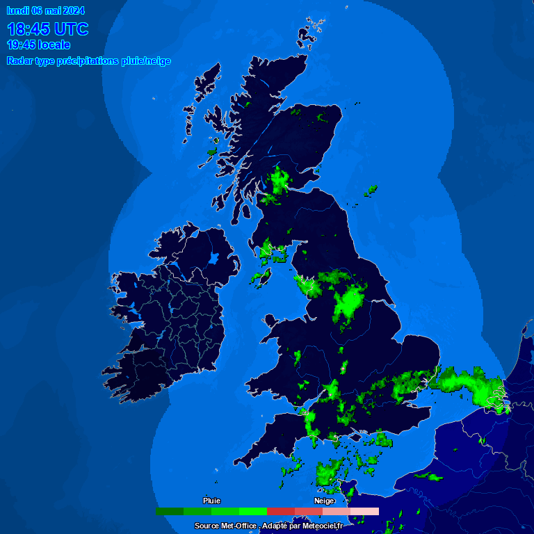
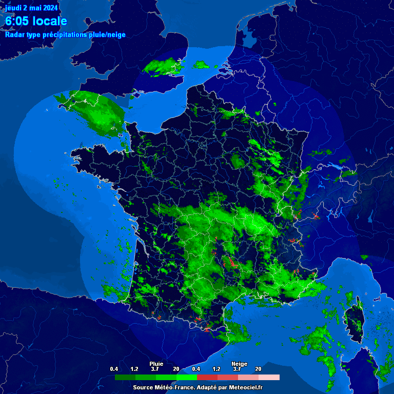
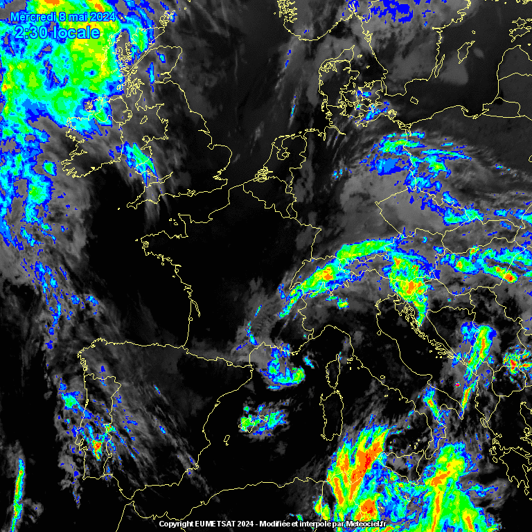
NW radar - screenshot at 1715 Live radar UK Live radar France Infra red satellite Standard satellite

Surely you've got some snow now? Have you looked out of the window
(sorry - not nice). Now, nobody should be overly concerned (just yet) about the green (wet snow/sleet/rain mix) and the blue (rain) on the NetWeather screen shot. The green is actually showing up over Exmouth now and I can assure you that we're having heavy snow and the temp is sub -4c. What we have is the less cold air (close to 0 c or just above) climbing over the dense cold surface air. Radars peer through these layers and pick up some rain or sleet at a high level and they are pretty inaccurate over sea areas anyway. Even if it is raining up there (which I doubt at this stage), we would either get freezing rain (possibly a dramatic ice storm) which would present some other serious dangers (I've posted about the 48 hour January 1940 event earlier this week on here and at length on the MOD last week which started and ended with a blizzard) it is very likely to turn back to snow again as the heaviest precipitation arrives very soon. Let's put everyone on here who, like me, lives on the south coast, on "freezing rain" watch. If the NW radar does pick up on freezing rain it should show up in a dark purple or mauve colour, The Meteoceil (France) radar shows simple snow or rain colours . Where NW has that green, Meteoceil have red or now white colours which shows very heavy snow. For those further east, see how that area coming out of north France is expanding. The extreme east of Kent, Essex , Suffolk and Norfolk should all be in line soon. Those purple, pink and even the white colours on the infra red satellite are the areas of much thicker cloud and usually contain the much heavier precipitation. When that reaches the Channel it will provide even great instability. Even if the snow turned to freezing rain, it would almost certainly turn back to extremely heavy snow. as it engages our deep cold block. Those darker colours are taking a little longer than expected to arrive - currently around Nantes and through Britanny. Perhaps another hour or so until we see the dramatic expansion of the dark red and white colours on the Meteoceil radar - it's already getting pretty dramatic out there in the Channel.
UK: Live temps GIF - last 24 hours Dew Point temps Wind chill temps Wind direction
France: Live temps GIF - last 24 hours Dew Point temps Wind chill temps Wind direction & strength
The south-west is warming up to -3c
When viewing the GIF 24 hour temp changes you need to bear in mind the min/max range. Less cold air has been making more northward progress this afternoon but there are still some sub zero temps in north-west France. The deep surface cold is still intact there (just) and it is only the warmer Channel (6c to 8c) that moderates that temp. Then in the UK we still have deep surface cold and the upper temps are not as extreme as they were last night. The winds around Emma are interesting! West in south-west Biscay and southerly in south-west France but easterly further north and across the UK. This means that even on the south coast, the surface air is still being sourced from around Belgium (eastwards) and still mostly coming over land with little moderation from the sea - this should prevent the slightly less cold air moving in until the winds veer to a more southerly quarter. Finally the pressure - our faithful Scandi HP is still there in situ but has declined . it'll be fascinating if it can hold on and forces Emma to stop moving northwards - the ideal scenario will be for Emma to drift east and that will enhance the easterly and ensure that the cold spell is prolonged for those of us that want that. I would love some clear sunny skies after the blizzard but we may still get a thaw and a slushy mess.
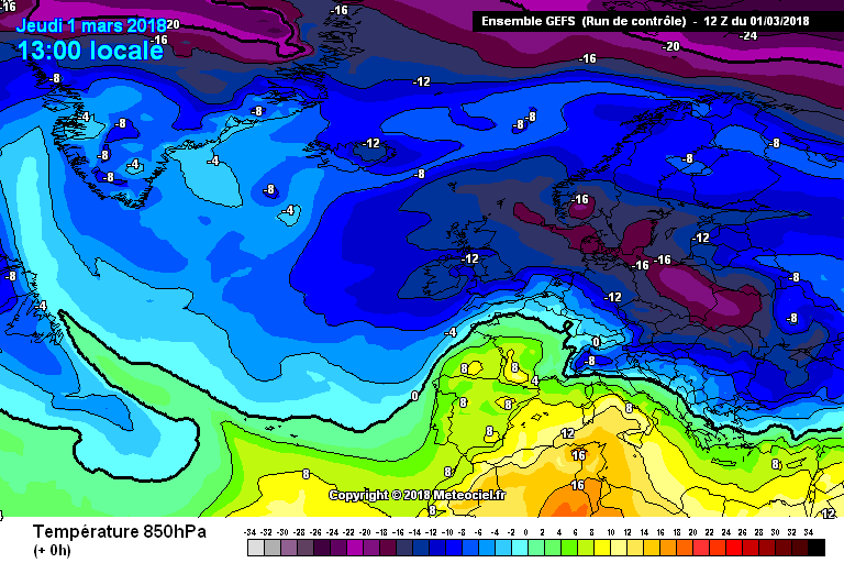
GEFS 12z T+0 1300 Mar 1st 850 Temps Live Euro Pressure GIF - last 24 hours Euro Pressure
STOP PRESS: THE MET O HAVE JUST EXTENDED THE AMBER WEATHER WARNING TO AS FAR AS LONDON. WHEN WILL THEY EXTEND THE RED WARNING? SURELY VERY SOON (OVERDUE IMHO).
Finally, I have near "white out" conditions now. The proper blizzards is well underway. This is the less cold air climbing over our deep surface cold. A classic undercut as in Feb '78. Enjoy
David
Thank you for your informative post. I have light snow falling again Which has left a powdering. No accumulations at present.
-
Ah I'm done for the day, can't believe I have once again missed out on a major snowfall while people in surrounding areas get covered in the stuff. I don't know why in my life I always seem to just miss out on major snowfalls. Seeing and reading other people's reports is far to upsetting for me. That's it for me, gonna turn to the bottle and avoid all forms of media.
-
Cloudy and dry here in barnstaple. No accumulations on ground. FML.
-
8 minutes ago, kent said:
According to the radar you should be under it by now with a lot more to come.
The radar is deceiving - I am not getting anything. There is literally no snow falling right now and when it does it so light. Literaly at the point where I feel like crying.
-
Can anyone shed any light as to why barnstaple is not getting anything. Will we get anything at all today?
-
3 minutes ago, Bazray said:
Very heavy snow now, road completly burried, been snowing since 7am.
It's fine to show the pics I do like to see them. I have no apprehension as to why we don't have snow here in barnstaple. Really upset and disalousioned but nothing I can do.
-
 1
1
-
-
1 minute ago, MrNooo said:
Not feeling the love for it currently, still have very fine flakes blowing around in the wind with no real depth yet.
Same as me. It's truely heartbreaking to be honest. Been looking forward to this for over a week. Really thought I would be nailed on for heavy snow.
-
3 minutes ago, Ben Sainsbury said:
Don't be so sure, that big area of orange/red in the channel has your name on it!
I hope so mate but we're just not getting any of the precipitation in this part of north Devon. The stuff seems have disintergrated as it gets here. 8 cm in Exeter Devon for instance.
-
Pathetic light snow with minimal accumulations in barnstaple north Devon. No heavy snow expected either.
-
6 minutes ago, Ydoj said:
I wonder if the estuary creates a pocket of warm area above us in braunton and barnstaple. The radars did show earlier a clear patch here- the only one in Devon! Think it is forecast to fill in but I'm no expert.
I don't think we will get any major snowfall - I am absolutely livid!
-
I have no apprehension as to why I am just getting light flurries of snow here in barnstaple north Devon when it seems the whole of the south west is getting shed in snow. Absolutely sick and tired of continuously missing out on major snowfallls by a matter of miles!!
-
1
-
-
Seem to have nothing here in barnstaple north Devon? Am I missing out?
-
How is barnstaple set to feature i this? We have Light snow and no accumulations at present.
-
23 hours ago, damianslaw said:
Where are you located - I've asked this before. We've had 4 inches not 2cms...
South lakes mate. Got 2cm yesterday. Other parts of Cumbria got a lot more.
-
Perhaps 2cm max here in south lakes as expected. Dry powder snow. Occasional flurries today but nothing significant. Might get a further dusting over the weekend but nothing significant. It appears the rest of the region has fared much better than Cumbria once again but hey ho. Standard.
-
For the 5th time this winter I woke up to a slight covering that barely covers all surfaces, maybe 0.2cm max. For the 5th time this winter pretty much everyone else, even in 'snowless' places like Preston and Manchester have far better snow depth levels than me. I predicted this, and it is indicitive of the winter so far but it really irks me when everyone else seems to fair so much better unexpectedly than I do. Can't wait for the cold snap to end and hopefully a good spring and summer.
-
5 hours ago, Geordiesnow said:
Just been asleep and I just woken up and seen its snowing outside with a light covering! Surely your location got some?
Either way, the radar suggests it's northern parts of the region at the moment that is doing well, wonder if the front end up further North in the end? Either way it shows its never straight forward predicting how things will go.
Morning mate! We seem to have the most meagre dusting of snow that barely registers on the depth scale. Speaking to colleagues of mine it appears areas around have a lot more, as with every other snowfall this winter. Won't be paying any more attention to this 'cold snap' as this is the best chance we will get. A truely awful, vile and sickening winter, which has failed to produce any more than a dusting of snow I am sick of it already! I looking forward to spring already to be honest fella!
-
Take the net-weather radar with a huge pinch of salt (and black pepper to taste!). It says I should be under a band of heavy snow. There is none. Whatsoever.
-
9 minutes ago, Astral Goat Juice said:
Looks like a direct hit to me. Just hope the mountainous regions dont sap all the energy
They will do. They are mountains. Its what they do.


South West and Central Southern England Regional Weather Discussion 22/02/2018 Onwards
in Regional
Posted · Edited by Barmada_Casten
I am in barnstaple and have a dusting, how do you guys think I will fare tonight and tomorrow?