


Snowjokes92
-
Posts
481 -
Joined
-
Last visited
Content Type
Forums
Blogs
Gallery
Events
Learn About Weather and Meteorology
Community guides
Posts posted by Snowjokes92
-
-
5 minutes ago, Craigers said:
I've always said things will improve each day and they have with 12z upgrades. Tuesdays snow will trend further south.
Yep and it would still keep whole county in firing line and benefit us for wednesday I think. Its a situation that can upgrade provided we see these small trends south and fortunatly for us its Yorkshire that will be in the sweet spot for it. All before the interest developing afterwards! Grab your thermals guys
-
 2
2
-
-
46 minutes ago, Tim A said:
Arpege is fine for a decent snow event, yes eventually pushing north and probably turning to drizzle but that is in line with the Met Office automated too, plenty of snow before then.
Can't seen it stalling over us for days but that was always an outside chance. Get out and enjoy the snow on Tuesday whilst you can.

Think the GFS is far too quick
I still think theres a good chance that the front wont make it that far north and with the assumption of gfs been maybe a bit progressive, it may adjust more south, meaning we have a good chance of it stalling over us and the borderline mild uppers staying south or been washed out. These adjustments south will give us a better oppertunity for Wednesday too. It could end up been a bit of a nowcast situation to wether its an all snow event, its very borderline. But majority of it will be snow, just need it a few miles south to keep any of those milders uppers away. Even if they do squeeze in, they get washed out quite quickly and its brief. The time frames coming up are where we want to see these tweeks. We are in the firing line, but really want an all snow event from a personal point of view.
-
 1
1
-
-
What do the experts think in here for Tuesday front? Can we expext any tweeks with uppers and dew point line filtering just south of region. My concern is the thought of it turning to rain as its very close to been all snow event or snow to rain for parts of west and south yorkshire? Uppers close to 0 and 1 later in the day, however if we can get uppers to stay south a tiny bit we should be ok. Something like the Gem 12z run actually!
-
1
-
-
33 minutes ago, Allseasons-si said:
Here are the graphs for London and Sheffield
an upgrade from last nights.
Interesting for Tuesday, the uppers starting to dilute by the looks of it for Sheffield with that front. More signs of mild uppers been washed out or not getting as far north and less marginal for some. Very good adjustments happening short term.
-
3
-
1
-
-
Just now, Winter Cold said:
It is hard not to start getting excited.
I keep reminding myself the last cold spell the other month went up in smoke about 4 days out and then there was the famous easterly implode at T72 in 2012!
But, we do have good model agreement so far and it's looking great.
Would love an appetizer this week and it's great to see the temps have trended down from 7c to 3c now on meto website for Tues! Are we going to see snow which hangs around for a while finally!
Today might be the last time we see 8c for a very long time!

I agree its hard to not get excited, but its the adrenaline rollercoaster ride before a possible big event that makes the whole thing worth while and interesting. Of course it can go wrong, but we stand the best shot now of the winter and support building across the models. Its not too far out and we have some great interest in semi reliable timeframe to look at.
I keep thinking of the snow event the other thursday and compare it with the even more potential on offer. Possible frequent snow events. Please be true!
Tuesday/Wednesday looks classic.
Hope its the last of any 8c weather too!
-
4
-
-
1 minute ago, LeeSnowFan said:
oh this comment gave me tingles!! ....
Its giving me tingles all this. I know things can go wrong, but we can see the potential even before an easterly. The snow would stick around and keep building as days go on providing we have the precipitation and in favoured spots for it. But its looking amazing.
Might as well make most of the potential and enjoyment before it happens, given everything else going on.
-
2
-
-
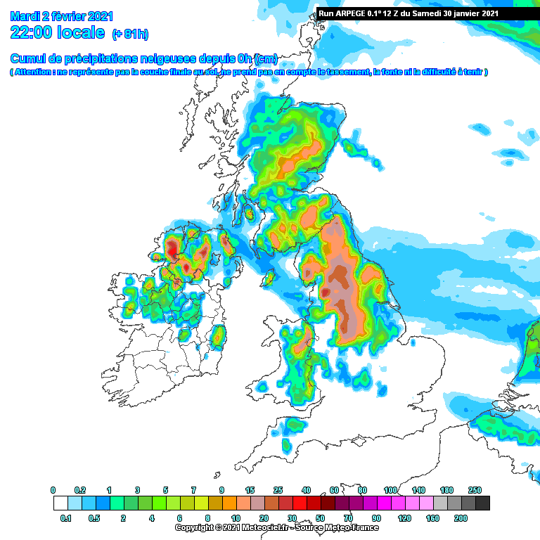
OMG the gfs 6z run! And even Tuesday/Wednesday from the ICON show a potential 24 hour snow event across Yorkshire and Central England!
All before any beasterly potential. The snow fields building all before any easterly. Loving this output❄❄❄
Btw on the Icon run, I am looking at the timeframes from 1pm tuesday to wednesday at 7am and the front is still sat across the county. So still going on after 18hours. Could be a 24 hour event maybe.
-
5
-
-
17 minutes ago, Frosty Winter said:
ICON 06z is going for an impressive snow event next Tuesday/Wednesday. Wow!

Wow some places with 18 hours of snow non stop and the front hasnt gone by that last chart! Setting up the snow fields for whats to come!
-
4
-
-
1 hour ago, Notty said:
and at 5 days
That ties in very well with the met office warnings for monday to wednesday could be a lot of snow and this is before a possible beasterly later in week! Amazing output. Very happy with the directions so far.
-
4
-
-
27 minutes ago, Craigers said:
Been talking to Steve Murr and he's optimistic about the easterly now. He got this idea spot on last week
Why does Steve Murr not post on here no more if you don't mind me asking. Enjoy his posts very much.
-
24 minutes ago, sheikhy said:
Tasty for central and northern midlands
Yes! Manchester and leeds do well also
-
2
-
-
Been waiting for you all haha. Feels like one of them unexpected events again. Fingers crossed guys and gurls... lets hope we get a good dumping after a naff old day of rain and misery lol.
-
Just now, Sunny_AS said:
On the North West thread.......
thought this thread may have been a tad busier with the goings on with this system moving in at the minute haha.
-
1
-
-
Where is everyone lol?
-
5 minutes ago, fazzafarrand said:
Very wet surprised not more on local news re rain, but suppose Covid and USA going on
bit colder to the West
Think everyone been pre occupied with rain/flooding, covid and usa at minute, so this is going to be a bit of a shock and it wasnt expected so soon.
-
^^Wow!!That green wintry mix is knocking on the door of yorkshire. Might be snowing here soon. You couldnt make today up!
-
1
-
-
Just now, Love Snow said:
Let’s hope we get a full surprise
Same I feel a lot of us will be looking at the North West thread
-
1
-
-
Just now, Harsh Climate said:
I think the key is how long the precipitation sticks around once conditions become favourable.
I'd expect due points to go below 1c from about 11-12pm tonight, initially in west and south yorkshire, then to most parts later.
Thank you. Im just at a lost with the situation. Not been too focused on tonights feature as didn't expect it to amount to much. Not seen any real mention on significant snow at all on here as thought it was looking too marginal. But after reading the North West thread just now and talks in there of 'witnessing something historic' its making me wonder if this snow event has been heavily under estimated? Just look how heavy thay precipitation is for a start.
-
I think we are on verge of been caught out yet again. Can imagine the roads beem dire once again tomorrow as its all been about flooding and rightfully so. Think most people wont assume any snow would stick with the amount of rain we have had. I know full well that theory hasnt a leg to stand on after last thursday snowfall
-
Just now, matty40s said:
It's all turning to snow in Manchestet already
Thats my thinking,but seeing how intense and slow moving it is, making me wonder if some places could see some significant surprise snow.
-
Looking at how intense that precipitation is thats slowly moving east, any chance some of that heavier stuff could result in snow as dew points start to fall?
-
Some momentum building in the models again, something is happening. Small tweeks in the short frame could throw something really good up for us I think.
-
1
-
-
Wow! More than I expected not stopped all day! Exceeded my expectations. Thick of it probably a good 10 to 15cm bit more in deeper bits as well! Also gfs 12z ensembles are sniffing out a very cold and snowy pattern and seems to have a lot more support. Trends slowly getting better at short notice after a wobble, usually how these events go. Think we could be in for some big surprises guys!
-
My only concern is the ground been quite soggy here for example. Its very puddly. Is this gonna scupper things or just rely on heavy snow falling?LOL.
BTW fingers crossed for you all. Lets hope its a winter wonderland


.png.a4c0fd4f763719de4396f496c0dbd416.png)


Yorkshire and E England regional discussion
in Yorkshire & E.England Weather Discussion
Posted
Still 60 hours away, will only take a few miles here and there for subtle differences where the boundary is and the trend has been to keep it south, which would likely stop any transition to rain. Will see though