


Mizzle
-
Posts
492 -
Joined
-
Last visited
-
Days Won
1
Content Type
Forums
Blogs
Gallery
Events
Learn About Weather and Meteorology
Community guides
Posts posted by Mizzle
-
-
3 minutes ago, Southern Storm said:
How accurate are mobile phone barometers this is what I'm showing at the moment. It was at 975.2 about 5 minutes ago! But it's undoubtedly not as accurate as a calibrated one, but it's fun to see it drop in real time.

My Grandad's old barometer seems to be doing well, reads 978.6mb (after doing the conversion).

-
 7
7
-
 1
1
-
-
3 minutes ago, 78/79 said:
I'm glad mine are grown up, there doesn't seem to be a great deal of common sense coming out of the mouths of some of these teachers these days. I can remember taking my two out of school for a holiday in the mid 90s nobody batted an eyelid.
As I understand it, schools are now rated on attendance, which is why they are hot on it and also why they close the whole school: if weather impacts some areas and not others, all of which are in the catchment area ( snow is a good example of this) then it is better for the school's rating to close. If they stay open and only half the children can attend then they lose points so to speak.
If they decide to stay open they are hell bent on keeping attendance numbers up.
Many a row I had with my daughter's school over their inane policy: one snowy year they actually had teachers visiting local snow spots to catch kids out.
-
2
-
1
-
-
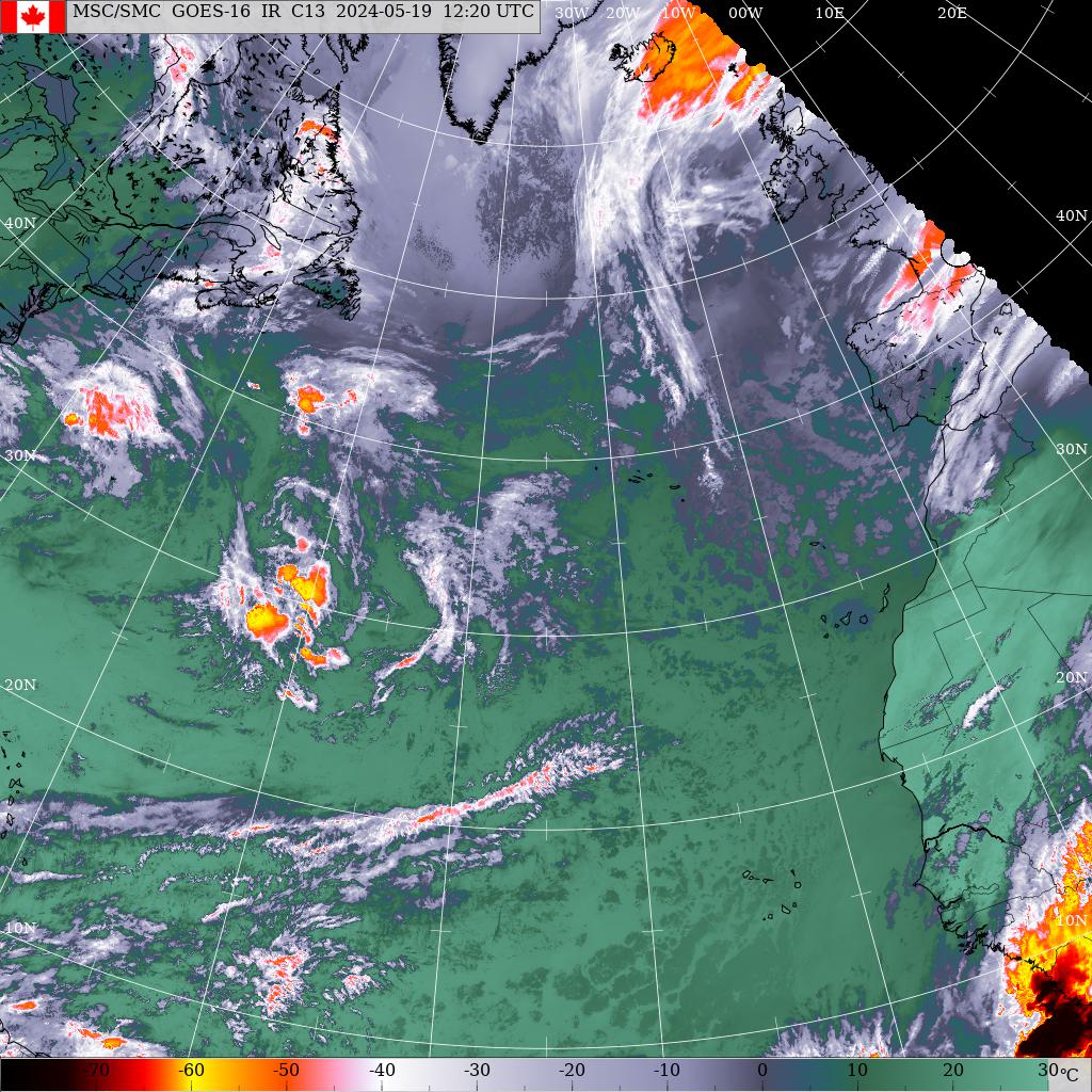
4 hours ago, Roger J Smith said:
For a good overview of current conditions after storm enters region south of Ireland, I would recommend meteociel.fr, you'll easily pick up options available for current conditions and you can choose a map display of France or UK and Ireland, or a wider view of all Europe. Until the storm passes 20W, you can see weather maps on the Canadian met site. I will link to the 06z map around 0700 (they appear about an hour after data collection at six hour intervals.
There is also a buoy located around 49N 13W and another closer to Brittany, both of these have hourly data and when I post that map I will post a link to data buoys. Within those links you can navigate around to other data buoys in the storm zone.
For now I will post a link to satellite imagery over the N Atlantic, and this link will update so later readers will probably be seeing a very recent image. Storm Ciaran is forming around 46N 25W (as of 0400) -- if you're reading around 0800 look closer to 47N 20W, it is racing along in strong jet stream. (10W is longitude near west coast Ireland and images display every 10 deg of lat, long, 50N is of course near Lands End).
https://www.weather.gc.ca/data/satellite/goes_sigwx_1070_100.jpg
Thanks so much for this.
-
2 minutes ago, Roger J Smith said:
Low is 989 mbs now at around 47N 32W.
Will be interesting to see if 00z model run displays any trends.
Can you point me in the direction of best place to view current status of developing lows/storms?
-
2
-
-
28 minutes ago, doctormog said:
It will only be the low lying areas not the entire town as being (mis)reported. The area around River St and low lying areas near the South Esk river.
BBC just reported 350 homes in the riverside area of Brechin to be evacuated.
-
1
-
1
-
-
13 minutes ago, Jo Farrow said:
There seems significant Rain Shadow effects in this E/SE wind, releasing the rain on the higher ground
As it was the first time I'd come across the term 'rain shadow', I asked the internet and had a few minutes reading this interesting wiki entry.
Rain shadow - Wikipedia
EN.M.WIKIPEDIA.ORG-
1
-
-
Woah! Wasn't expecting that. Booms going off around me and I thought it was the farm machinery as harvest is going on. And then the strikes!
Was this expected?
-
1
-
-
That blob over Reading has delivered a.magnificent sunset

-
8
-
-
Currently at Cheesefoot Head nr Winchester: light show and rumbles across the downs are getting stronger. Best storm view this season!
-
1
-
1
-
-
Provisionally the hottest day of the year.

-
1
-
-
Already registering at 32.5C imby. Local weather station registering 31.2.
3 hours ago, Mark wheeler said:Wow what a sparkling and lovely start to the day. Crystal clear skies and gone is the high level cloud of yesterday.
On a stag do today that kicks of a 12 so need to be careful with the hydration , especially as we are going on one of those beer bike things later on .
I'm overheating just thinking about a beer bike in this heat

Have fun and yes, stay hydrated

-
Hit 30.1C here now...wondering how high it's going to peak today with a few hours of heating to go.
-
29.2C here in NE Hants. Another hot day.
-
1
-
-
Caught the sun breaking through whilst out walking the dog this morning. Hit 30C yesterday and expecting more of the same today.
-
3
-
-
Wow...some rumbling and some sturdy rain...very nearly a storm here in NE Hants. @Flash bang flash bang etc are you hearing more than one today in Surrey?
(Strikes along M3 route according to Lightning Maps)
-
33 minutes ago, Flash bang flash bang etc said:
Lol
i got a commiseration bonus. One boom

Undoubtedly the very same one I heard whilst walking the dog. One.

-
5 hours ago, *Stormforce~beka* said:
I joined the FAcebook page
What's the title of the page?

-
9 hours ago, ChannelThunder said:
While it's relatively quiet, I just wanted to drop a link to my Arizona Monsoon blog, that I am planning to update daily while here chasing with Paul. There'll also be pics on my FB page.
https://arizonalightning.wordpress.com/
https://www.facebook.com/LanceMorganLightningPhotography
It's been an eventful start. My connecting flight at NYC was held for over two hours last night by...wait for it... severe thunderstorms. Now that's ironic! And just an hour ago, I was already treated to my first monsoon storm, spitting out bright pink CGs!
I've had about two hours' sleep...
Good luck with the storm chasing...I'll be keeping up with the blog. Thanks.
-
2
-
1
-
-
2 hours ago, NYCSnow said:
Doesn’t seem anywhere near as windy here as the previous windy Saturdays last month despite this being a named “storm”. Currently quite calm here. Still, it’s yet another utterly atrocious weekend day for a summer month, very wet early and again this afternoon with a rumble of thunder. Sunshine measurable in minutes (about 3) and chilly. With almost no sun all week the house is really quite cool, more like March than August

Not too far from you ( Fleet) and this is my August afternoon!

-
3
-
-
It feels like I have woken up in September here. Sunny, gusty and cool. I am not sure I can remember a July like this.
-
2
-
-
- Popular Post
- Popular Post
23 minutes ago, Steel City Skies said:We need some balance here because it does depend on where you live and what sort of views you have. I have to travel about 5 mins to get an uninterrupted view to the W/NW or N for example, but I have good views to the E/SE/S just a very short walk away (<2 mins).
It's wishful thinking to expect a direct hit everytime, it rarely happens and when reading reports on the storm section of a weather forum it can give a rather skewed picture of just how many of us are really experiencing an overhead thunderstorm.
Yes, today the storms missed Sheffield to the east but, with a decent view in that direction there was an excellent opportunity to see cg lightning as well as good storm structure. We should appreciate what we do get, rather than lament what we don't. For those with half an interest, Sheffield has done fine for storms this year - other spots have done better, some far worse

I must admit...watching storms from a distance is probably more fun than being under them IMHO. Unless you are directly under a cracking one ( rare) then it can all be rather grey, wet and short-lived. From a distance - and if you're lucky enough to chase - you get to see the development, the awesome cloud formations, the anvil, the fronts and the get to watch as it rolls away: beautiful.
At night, can be just as stunning: watched this one develop through early evening and as the sun came down ( 11 Aug 2020). Massive cell over Reading and an awesome view from (literally) imby.
-
11
-
19 minutes ago, *Stormforce~beka* said:
No way! You mean I missed the fun that close?! Sheeze! ...
It was a nice surprise...really wasn't expecting anything other than rain. Had a good 20 mins or so of flashes, cracks and rumbles. And. More importantly, plenty of rain - so guess who doesn't have to water the garden today?

-
1
-
-
Wow! Wasn't expecting this... bright flashes and almighty crack and rumble. Bonus activity for me today.
-
5
-
-
Rain and rumbles just started here in NE Hants.


Storm Ciarán
in Storms & Severe Weather
Posted · Edited by Mizzle
Additional question.
Family in Southampton are reporting a decidedly underwhelming event so far too.
So is it just moving slower than forcast? NE Hants forecast was for 40mph gusts at this time, so far just a bit of rain.