


Porto
-
Posts
124 -
Joined
-
Last visited
Content Type
Forums
Blogs
Gallery
Events
Learn About Weather and Meteorology
Community guides
Posts posted by Porto
-
-
Bloody hell, if the BBC is anything to go by, 7 hours of up to 70mph gusts for myself.

-
 1
1
-
-
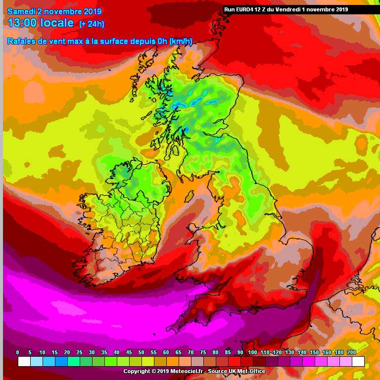
AROME has finally come into view for Sunday. Somewhat general agreement with other models, perhaps a little less winds in some places, but 60-65mph almost everywhere at some point. Plenty of 70mph spots too. The AROME might also give an indication of why there are Amber warnings in the SE and nowhere else (yet). Towards the very end of the run, a sort of 2nd wave of winds moves into the SE more or less within the warning area. Perhaps this extra time of sustained winds is what tilted the scales in the SE for the warning? May have been noticed in other models that the Met has. I still expect a widening of the warning area though.
-
1
-
-
40 minutes ago, Porto said:
For myself, the BBC ever since the change in provider have been a lot slower than the Met in showing the correct winds. Sometimes just being outright wrong (Storm Brendan the BBC barely suggested even any gusts). However at this exact moment in time, the BBC peaks at 61mph (after showing 66mph earlier) and the Met 62mph (after showing 67mph earlier). These values seem potentially a little low and the downtrend is definitely interesting considering the models are currently going the other direction. This is of course all computer generated and likely delayed too. I don't even bother looking at Accuweather, its ironically the least accurate from previous experience.
All in all who am I to say they're gonna end up wrong until it happens, it just feels like based on models they may be. If it turns out right, that yellow warning may be more accurate that im giving it credit for. (at least very hyper-locally)
The BBC's ear was itching clearly. Back up to 67mph. Im sure the Met will follow suit in its next update. Kinda hard to ever really take seriously with swings like that. Mind you, wind is wind. Its not exactly a 100% predictable thing for gusts.
-
For myself, the BBC ever since the change in provider have been a lot slower than the Met in showing the correct winds. Sometimes just being outright wrong (Storm Brendan the BBC barely suggested even any gusts). However at this exact moment in time, the BBC peaks at 61mph (after showing 66mph earlier) and the Met 62mph (after showing 67mph earlier). These values seem potentially a little low and the downtrend is definitely interesting considering the models are currently going the other direction. This is of course all computer generated and likely delayed too. I don't even bother looking at Accuweather, its ironically the least accurate from previous experience.
All in all who am I to say they're gonna end up wrong until it happens, it just feels like based on models they may be. If it turns out right, that yellow warning may be more accurate that im giving it credit for. (at least very hyper-locally)
-
1
-
-
Honestly it feel like government related entities and infrastructure are paying attention more to the actual potential severity than what colour the warning is. Which is good. But as we've all said, it makes you think about why the damn warnings even exist if train companies etc are calling for cancellations and slower trains even when in a typically "tame" yellow warning. Of course it does seem like a damned if you do damned if you don't scenario for the Met... But picking the South East exclusively doesn't seem to line up with any models that we know them to typically use (and have access to).
The 12Z ECM I was surprised got even more windier, when ive been expecting general "downgrades" (even if small) as we come closer to the time. It suggested 78 MPH gusts right on the Greater London border near myself. While I don't expect it to get THAT high, this will absolutely be the worst storm since 2013 where we lost our fence, and had power flickers. And that was relatively short too. These winds are meant to be gusting at 60mph for many hours, above 50mph for almost a whole day. If they don't expand amber to at least the SW and Wales, then I don't understand the warnings existence.
-
2
-
-
The amber warning will absolutely be spread out further. Its mostly down to confidence at this point and 24 hours prior may just be enough for the scales to tilt. I live right on the edge of London, and the forecasts for the past 3-4 days have suggested anywhere between 65-70mph gusts. The fact that i'm not in the amber warning is strange, especially as this may be the strongest storm since 2013 here, but the edges usually chosen by the Met are perhaps a little arbitrary (aka I think they just chose the M25 as this kinda supposed magical wind barrier)
-
The exact strength of winds and where they are, are gonna vary over the next few days. But I think its pretty certain this storm will cause pretty big disruption across the entire country. ICON, GFS, ARPEGE and ECM all agreeing on my area to receive around 70mph. That alone makes me think that big downgrades aren't super likely.
-
2 minutes ago, Man With Beard said:
Back to the present... Are we underestimating this storm tonight? Up to 90mph gusts on the EURO4 even in a couple of built up areas like S Wales. There could be quite a bit of disruption, but media surprisingly blase?
There's definitely a lot of uncertainty to it, models don't have widespread agreement, and probably why the Met has their warnings so low on their Impact Matrix. ICON/EURO4/ECM all going for some pretty nasty storms, GFS and others less on board, although GFS definitely upped the speeds in its 12z run.
-
4
-
-
Tornado watch issued in the SE by TORRO. Interestingly they don't actually update their website anymore, but rather their Facebook page.
-
1
-
-
Unless we somehow still gain another .5c I think we can safely say the all time record is safe for now
-
4
-
-
-
Record broken at Heathrow
-
8
-
-
Cambridge showing up as 37c on the Live list, however confirmation from the Met of what exactly that is would be nice. Could still be 36.5c rounded up.
-
2
-
-
Cloud starting to get onto land now. Heathrow and Northolt will struggle I think to get much past the July record. Well, unless that cloud starts to fizzle away substantially.
-
1
-
-
... Although according to the Met Office they hit 35.9c
-
34.3c at Heathrow and 34.7c at Northolt, lost about a degree in temp. Cambridge hasnt updated yet.
-
Judging by how much cloud is coming up the channel now. I think that overall temperature record may prove hard to beat now. July record I still think is probable (and we may find out in the next hour or so where)
-
I think Heathrow and Northolt may have some cloud over it currently, at least according to the satellites. Cambridge may continue to be the hottest area until that cloud clears away a bit before the main area of cloud coming up from France.
-
36c in Cambridge at 12:30 according to the Netweather live list. Suspect its rounded up
-
1
-
-
35.1c at Heathrow
-
Cambridge has hit 35c
-
Not sure if the people in this thread saw the Met Office tweet about 34c at Kew Gardens at 11am earlier. Kew may be the place to break the July record initially.
-
2
-
-
Rainband currently in the south fizzling out rather quickly. A similar scenario happening east nearer the London area would likely mean barely anything left by the time it reaches the Heathrow/Northolt/Kew Gardens warm trio.
-
About to take over yesterdays high and its not even midday. 5 hours of warming left, providing the thunderstorms coming up from France don't interfere too much. Also another 6.1c onto that and it'll hit my very ambitious 40.1c guess at Kew gardens
-
1
-


Storm Ciara - Atlantic storm 3
in Storms & Severe Weather
Posted
Usually the other way for me. This is the one scenario they are higher. The BBC does seem to follow the model outputs more closely. I expect high 60's and low 70's so its probably not COMPLETELY off.