
- Popular Post


Eagle Eye
-
Posts
7,217 -
Joined
-
Last visited
-
Days Won
42
Content Type
Forums
Blogs
Gallery
Events
Learn About Weather and Meteorology
Community guides
Posts posted by Eagle Eye
-
-
There was a massive CG bolt a few houses away from me but my phone over exposed it and my camera ran out of charge a few seconds before the strike
YOU HAVE GOT TO BE KIDDING ME
Anyway, did manage to get a distant CG and the brightness on my phone from the other CG showed how close it was.

Some unsaturated photos to enhance the lightning as it wasn't showing up well on my phone very well.
Then some decent structure showing earlier in the event looking to my NE.
-
 3
3
-
-
Brenzett seems to be the area where the most lightning hit.
That's like 13 per square KM in that area.
Can I also say, well done to the ECM for being almost spot on with this from around Wednesday onwards.
-
2
-
 1
1
-
-
- Popular Post
Lightning stills going on now but here's the best I could make with my phone as it went over , interested to see what my camera got which ran out of charge seconds before a CG which was too over exposed on my phone (one of these here) and landed about 200m away from me. Might have been a brief funnel cloud or something as from what I could see, there was some rotation when it had gone through here mostly (about 20 minutes ago) with something that looked like a big funnel cloud, maybe an updraft where the rotation was but that was with just my eyes.
-
11
-
There was a massive CG bolt a few houses away from me but my phone over exposed it and my camera ran out of charge a few seconds before the strike
YOU HAVE GOT TO BE KIDDING ME
-
7
-
-
So far but by no means over
-
3
-
-
Spider lightning to my south that I missed.
-
Hardly anything showing on camera despite bright strikes.
-
Loving the sky here
-
2
-
-
- Popular Post
Oh wow
-
10
-
Sky looking decently plume like in my experience, phone doesn't capture it well though.
-
5
-
-
Replacement of less unstable air parcels around the channel island looks to be replaced for some more unstable ones very slowly, with the movement of it, I would suggest that they will ride up the convergence which looks to be happening now and moving North, I expect more Storms to form with this. Very slowly moving North I would say but still signs of it moving North.
-
2
-
1
-
-
30 minutes ago, The Tall Weatherman said:
Looks like later in the extreme south eastern parts of Essex tonight it will proper go bang ! A convergence zone feeding on 1400+ Cape is sure to deliver a very frequent lightning show so for the lightning lovers like Eagle eye it looks like you are going to have a nice night !
I'll be watching out definitely, time to charge up the phone soon as its getting quite low.
-
7 minutes ago, Kirkcaldy Weather said:
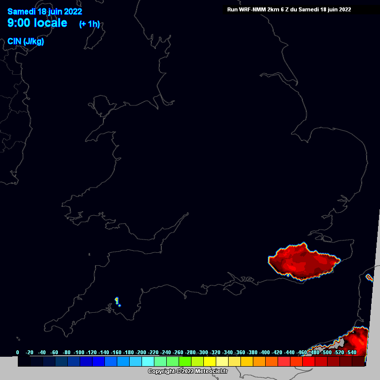
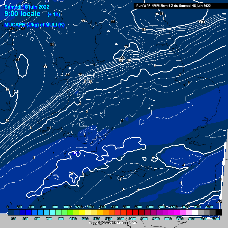
My main model that I focus on is the wrf nmm 2km it hasn't been fussed at all for developing storms whereas the ukv was more keen to, the issue I think is at play is CIN (convective inhibition)
Convective Inhibition (CIN): Definition & Role in Forecasting | Study.com
STUDY.COMIn this lesson, you will learn about the meteorological concept of convective inhibition, how it impacts potential thunderstorm development, and...Here's the latest wrf nmm 2km showing the CIN
along with that there isn't much CAPE to speak of the front is probably giving enough forcing to generate those showers but with the lack of CAPE in combination with high CIN they are unable to grow into big storms that some were possibly expecting 
That CIN is shrinking tonight as I thought it would with the arrival of the troughing and so I would say that the Storm chance will hold strong it's just where it is as the front suggests a more northern initiation but CAPE may extend as far south as expected but also extend more northern.
-
2
-
-
24 minutes ago, Polaris said:
Well after the pathetic media frenzy over a 1 day hot spell yesterday, it’s now intermittent rain/drizzle here. Other countries must pi** themselves laughing at us.
Looking forward to next week, models firming up on a pretty decent week of sunny conditions and warm temperatures.
I'll refer you to this comment I made to my Pakistani friend who said our temperatures are cold when the heatwave was mentioned.
"Not when you're used to 20°C, temperature is relative and your body will naturally get used to what you are in the most so actually it's like you being in temperatures 15°C above what you normally experience although because you experience hotter it's more like 20°C above what you normally experience, that's what it would feel like"
-
4
-
-
12 minutes ago, Scott Ingham said:
It means storms will be 50-75 further north than predicted on yesterday and this mornings models.
There is a prediction for storms to fire off the southern side of the cold front.
These will be further north
They were almost all over me based off the ECM but I was on the most southern extent, am I still within a chance then or should I not bother since I've got cricket tomorrow.
-
Interesting skies here
-
3
-
-
Here's what I texted my family about tomorrow's risk and will probably text my friends as well.
"Potential for more Storms tomorrow evening/night comes from a cut off low lifting North from Portugal tonight and brushing the SE tomorrow evening, bringing with it cooler air with more moisture aloft, this means that surface capping (capping is essentially dry air that cannot be lifted) over France will be relatively strong keeping Storm development over France to a minimum throughout the day. However, later into the evening, that cool moisture aloft will push up through France and enhance elevated Storm development unless capping forms in the mid-levels of the atmosphere as well as surface based which would require the buoyancy and lift in the atmosphere to be low. If elevated Storms do form in enhanced upper-level heat profiles then as the low pressure moves further North it will continue to bring that moisture and energy with it and elevated Storms are much more likely to cross the channel as they are unaffected by the heat of the channel. Based off the amount of Storms that did form over Portugal and Spain today I would say that the buoyancy and lifting are strong for now but those can change over time. Therefore potential tomorrow lies on the movement of a cut off area of low pressure and just how much moisture forms and what happens with the capping."
-
5
-
-
33 minutes ago, Mapantz said:
Everyone I bumped in to over the last few days has used the word "glorious"
I cannot argue with that!
Agreed, everyone in my school said it was overly hot but I dont think it is at all, more of this over the Summer, I would welcome.
-
3
-
-
19 minutes ago, Ben Sainsbury said:
UKV 6z quite similar to NMM, some decent instability and strong DLS across the SE. Could be some very electrically active cells initiating for a time tomorrow evening as they clear ENE into the North Sea and Mainland Europe.
Would you say I'm in with a shout or will I have to hope that I can see them to my north or to my south?
-
1
-
-
The ECM has been continuously modelling the same thing hence why my area of concern for thunderstorms on land (didn't include the channel)from a couple days ago wouldn't look out of place if it was based on this run.
There is decent cross model support for this but its far from nailed on.
-
Last frame of the UKV run for early Tuesday morning, perhaps picking up a new potential? I don't think so but it might be based off the ECM.
-
2
-
-
7 minutes ago, LightningLover said:
Looks more like torrential frontal rain to me? Perhaps some lightning embedded initially...
Maybe, I don't know to be honest, maybe a typical Eastern destabilisation kind of thing.
-
1
-
-
UKV run because wow.
-
1
-
-
The ECM suggests significant thunderstorms are possible Saturday night, with what look to be imports, developing over the north sea and the channel.
Shear is forecast to be significant with this, I would suggest the potential for Supercells and with 50 knots of low-level shear tornadic potential is possible if Storms can form to be more isolated rather than an MCS which would be very scary at night (consider that shear typically strengthens at night as well).
Deep-layer shear of 70 knots is incredible for the UK and does suggest Supercellular development is quite likely, which models such as the ECM find it hard to
Multiple models are beginning to show an idea of some CAPE forming over areas across the east or the south of the UK on Saturday in the day, the ECM on the lower end of this.
The Swiss model has a ridiculous significant tornado parameter that would suggest to me that a tornado is potential in the day as well with Supercellular development possible, I would suggest the midlands may be the best place in the day, with a low CAPE high shear event that seems to be modelled by quite a few models but it needs that CAPE to actually occur.
A couple models showing significant CAPE on Friday, the Canadian model on the extreme end of that.
Looking at it from a sense of model agreement and we're finally getting it for Saturday.
Significant cross model agreement for Saturday with troughing to the South and a low to the North. This is good for two facts, it rises the potential for imports and typically, trough's seem to push North quicker than modelled and so, in the day, CAPE could be higher than the ECM is currently showing and in theory the UKMO is the most likely to be correct. Supercellular wise, shear is more likely to advect quicker and even though temperatures may be weakened slowing down the breaking of any CAP but once the trough passes over your area, that CAP is likely to erode quickly. Theta-W is likely to advect even further North than currently modelled, rising the potential for Plume Storms to be elevated and move further North and we're far enough away from the centre of the trough that these values are unlikely to cool down by the time night arrives.Finally we have some agreement here and with that, comes, what I expect, temperature agreement in the next couple runs especially from these models, the GFS is out on it's own now, so don't worry about it's temperatures.
-
2
-


.png.c0dc77c6b3f43664eb8c5707835b382a.png)


.png.dedbb2009cfbc85a67651556869ba0ab.png)


.png.0588123aff9e24e03836795c526ea4ee.png)
.png.d7c4ed854454a710f2dbd4aecd45006d.png)
.png.296fd05bbac12003a437fef6e42b3762.png)


Storms and Convective discussion - 1st May 2022 onwards
in Storms & Severe Weather
Posted
Not often do you see this over here, it's usually one Storm heading NE and clipping Kent or something similar to that. This year has been especially good for imports compared to previous years that I've been on here for, let's hope this continues and we get something for more of us in July from a night time risk, for now I think this is the best we'll get for night time Storms here in the UK for a while but another short burst of heat followed by some sort of troughing may trigger that elevated convection again.