


beng
-
Posts
497 -
Joined
-
Last visited
Content Type
Forums
Blogs
Gallery
Events
Learn About Weather and Meteorology
Community guides
Posts posted by beng
-
-
For the record and speaking from a fair amount of experience here, the UKMO tends to be about the best at calling easterlies correct in terms of will it happen or not. I remember it picking a scandi high as far back as Dec 2002 way before the other models got there and there's been quite a few times it's said NO to the other models too in recent years.
The fact that UKMO is basically there with it (plus it's been trending there last 36 hours) would make me think it's now a high probability. Easterlies are never nailed on until at least t72 though.
-
 3
3
-
 1
1
-
-

UKMO 144 - similar to this morning - just need a bit more energy SE under the block
-
1
-
-
2 minutes ago, karyo said:
A slight improvement from the ICON. Although a low pressure makes it through the UK from the Atlantic, it then dies over the north sea and a ridge of high pressure from the southwest tries to link with heights to the northeast at 135 hours. It may not make it in this run but the Atlantic is slower and further west.
Looks fairly similar to this morning's UKMO at first glance
-
4 minutes ago, CreweCold said:
why I'd rather take my chance with some Atlantic sector heights rather than chase an easterly!
You don't have a choice in the matter, the weather will do what the weather will do
-
5
-
-
48 minutes ago, TEITS said:
If im going to have the Tut taken out of me then I won't bother.
Suffice to say the mistake everyone is making is they are ignoring the fact the UKMO at +144 is very different to every model at that timeframe. The +144 like last night is a text book classic of an impending 1980s type E,ly. Just wait and watch how the high to the N will extend SW with its associated cold pool whilst at the same time any atlantic intrusion heads SE. The date of arrival for a classic 1980s E,ly is around 15th Jan!
As I read it, it looks like there's differences over the Arctic and Siberia on the UKMO relative to the ECM/GFS at 120 hours. 2 areas of low heights over Siberia which UKMO is slower at merging than the other 2 models - which results in a cold pool staying further West across Russia on the UKMO - which then makes the higher heights over Scandi more stubborn to shift. Either solution could be correct, but it just highlights again that no one should take anything past t96-120 as gospel right now as the differences over Russia at t96-120 could result in major changes for the weather the UK experiences.
I'd argue that it also shows that in a blocking scenario, 'downstream patterns' can be important - as well as the upstream flow out of the US/Canada.
-
1
-
-
Model carnage (maybe that's too strong) again - but it's not exactly unexpected. Over the last few days as things have evolved, we've been seeing the GFS sending a bit more energy south relative to what it had, and the ECM sending more energy north relative to what it had - basically the bias of both models is exposed for all to see.
However, let me throw out a darts analogy (not often you get that in the model thread!), if you throw at triple 20 and hit just slightly too low, on your next dart you adjust - maybe you get a bit closer. Then you throw again, this time you've adjusted too much and end up above the wire. On your next dart you adjust back the other way, and finally you hit it. In short the models are still adjusting - especially at the 144+ time range. What often happens during the downgrades is that the models over adjust one way, and then re-adjust back somewhat a few runs later.
So for the next 10 days probably no -10 uppers from the East with convective snow, but we only need to adjust very slightly (in terms of more southern jet energy) to create a very snowy battleground.
-
7
-
-
Just now, northwestsnow said:
Yes karlos the 144 was better than i expected
Be interesting to see GEM at 144- i dont think ukmo is anywhere near as good unfortunatley..
Looks like the initial Easterly won't amount to much in my area at least, but if we get a subsequent split jet with enough energy South, then the eventual follow-up could be a stonker (best guess somewhere around Jan 13th/14th)
-
1 minute ago, Steve Murr said:
Perhaps a lot of Confusion here -
The broad scale pattern is almost identical on all 3 models -
144 long fetch Easterly
UKMO fetch is about 90/95 degrees East
GEM is about 80 degrees ENE
thats the difference between -8c in the SE or 0c ....
Fine margins then - for my location at least.
-
1
-
-
8 minutes ago, snowray said:
UKMO not so good but blinding GFS, we have our easterly with the COLD uppers too! And lots of snow in the far south this time.
That's showing rain for much of the South. I reckon we might get lucky though, but need to see the models tweak the output a bit more first.
-
1
-
-
1 hour ago, Ed Stone said:
Oops! January 1st to December 7th?!
Global cooling, no summer this year!
-
9 minutes ago, TEITS said:
GEFS mean and at +156 the colder temps are only slightly further SW. Little change for most of us though compared to 0Z.
Still unconvinced much will come from this E,ly except for Scotland and maybe NE England.
Actually quite a few decent easterlies develop in the 6z ensembles by the looks of things, but may take 2 shots to get there so to speak.
Edit: there looked to be at 180h, but mostly gone by 204h, but that good just be the ensembles being too progressive, clutches straws.
-
1
-
-
1 hour ago, Steve Murr said:
Whilst it may appear tame take it V the context of the last few runs
watch the dip get deeper...
Are you thinking of pressure dropping towards E Europe/Germany (lower than currently modelled) with the pressure build near Scandi which will then send more cold West - assuming the models are right about the pressure rise to begin with?
We've seen this before with this kind of setup.
-
1
-
-
Longer range GFS is complete nonsense with a relative heatwave heading to Moscow. Experience says there's zero chance that's going to happen, not like that anyway.
-
Just to offer a bit of hope - this is a chart from 20th Dec 1970 -
there's a few similarities there in terms of the ridging on the US/Canadian West Coast and the Atlantic pattern too - relative to GFS forecasts (Joe B has been talking about 1970 a bit and you can see the broad-scale similarities). BTW - I don't bother looking at the ECM op past 144-168h these days as rightly or wrongly I no longer trust it at this range since the last upgrade.
Here's how Christmas day 1970 looked:
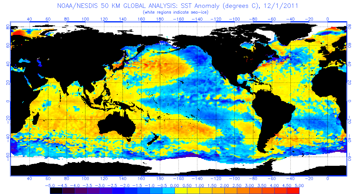
I think what's been hampering us for a while though are the SSTs around the Azores which are still a bit above average -
that just doesn't help when it comes to splitting the jet and getting energy South into W Europe. I think we have the atmosphere wanting to play ball, but for the moment Atlantic SSTs are working against us being able to lock in a cold pattern.
-
5
-
1
-
-
http://www.meteociel.fr/modeles/gfse_cartes.php?&ech=222&mode=0&carte=1
This could just be the first sign of some amplification returning in the atlantic in response to the reforming Canadian West Coast ridge.
-
1
-
1
-
-
10 hours ago, bluearmy said:
Not a fan of fi gfs strat data but these 16 day op and ens charts are where I think we could be headed with the Pacific ridge splitting the vortex and upwelling
Not quite sure how that'll translate at the surface, but doesn't look great for us I suspect (split vortex but with one segment keeping westerlies going across the Atlantic) - please tell me I'm wrong! :-)
-
This produced a big 'real' blizzard in 1981 - although it turned to rain in the south (much to my annoyance at the time). It's very rare to get the wind and snow to combine like that across a large area in the UK.
-
1 minute ago, West is Best said:
I guess we all know that the chances of this happening, even at T150 are on the slim side. But it's worth pointing out that if it did, unlikely though it is, it would be blizzard conditions such as we've not seen for a veeeeery long time in this country:
Probably since Dec 1981 on such a large scale
-
1
-
1
-
-
Just now, Cloud 10 said:
Yes,some real drama from the GFS at day 6,with some crazy temperature contrasts telling a part of the story.
850's..
2m temps..
Presumably that's part of the reason the model is blowing up the low so much. Reality is probably somewhere in between UKMO and GFS - so hopefully the ECM will deliver that later.
-
1 minute ago, northwestsnow said:
Indeed!!
Need that low to do one though its eventually dragging less cold uppers into the mix, down south please mr low...
Assuming the reality was to be a less deep low, then the warmer uppers coming in off the N Sea may not be an issue in the end - fingers crossed.
-
3 minutes ago, Iceberg said:
It’s impossible to over state the effects of gfs from t144 to t180 or so. The amount of snow and 70-80mph winds would be a story for the next 50 years.
The really unusual point is that it’s all quite realistic given the Synoptics and timeframe, if still unlikely at this range.
GFS tends to overcook lows of course - but even a slightly weak version would be quite something.
-
11 hours ago, Catacol said:
Latest Metoffice update has the 3.4 region dropping to -1.5 or maybe lower... though some members are less cold. This isnt good. Takes Nina forcing into 1988/89 or 1998/99 territory.
I think 1.5 is the peak dip though - not the 3 monthly figure; take 88/89, the 3 month figure at the low was -1.8 for the 3 monthly period of Nov, Dec, Jan - which would be quite a lot stronger that the 3 month figure predicted in that MO graph.
http://origin.cpc.ncep.noaa.gov/products/analysis_monitoring/ensostuff/ONI_v5.php
I don't think La Nina will be major this coming winter - we've had a couple of noticeable positive burst in the SOI - but nothing that screams major Nina in-coming (yet at least):
https://www.longpaddock.qld.gov.au/seasonalclimateoutlook/southernoscillationindex/30daysoivalues/
Assuming that's true, then this La Nina, will not impact the stratosphere in the same way that the 89/89 98/99 events did. Those years also had a higher solar forcing than we've got now.
-
2
-
-
Far be it for me to disagree with Dr Cohen, but I'd suggest that a 'stretched' vortex like that (towards Baffin and away from Greenland to some extent) would be more consistent with something of a blocking signal over W Europe - maybe Scandi. Doesn't imply deep cold by any means, but possibly dry weather for UK - especially as you head into the SE. Possible moist westerlies for NW areas.
-
2 hours ago, summer blizzard said:
Somewhat neutral. We have a +EPO pattern from the anomolies near the west coast (-PDO like) but the central and west Pacific are just generally warm rather than indicative of a PDO state.
This a more classic -PDO pattern..
Just to add to this, you can see the PDO data value here http://research.jisao.washington.edu/pdo/PDO.latest. I'll take a punt and 'guess' that we'll be weakly negative by Dec/Jan.


Model output discussion - into 2018
in Forecast Model Discussion
Posted
Nope, it's taking too much energy north after 144 hours.