


beng
-
Posts
497 -
Joined
-
Last visited
Content Type
Forums
Blogs
Gallery
Events
Learn About Weather and Meteorology
Community guides
Posts posted by beng
-
-
59 minutes ago, s4lancia said:

Quick question - given the model is forecasting the upper vortex to be displaced towards Siberia whilst pressure rises at 10hPa towards Alaska/Canada - does that also tend to force the vortex in the troposphere towards Siberia too? If not always, what kind of factors would need considering too? I'd assume the answer is a 'not necessarily' type answer - otherwise warmings would nearly always produce similar broad-scale outcomes at the surface (in terms of where blocking sets up) - but as we've seen to our costs in terms of cold in the past, that varies. Thanks in advance to anyone that answer.
-
1 minute ago, feb1991blizzard said:
Forget February, the atmosphere could be nina like by then, we are more likely to get a Samantha Fox - 'I only wanna be with you' February than an 86 or a 91.
Feb 86 was a la nina.
-
 3
3
-
-
12 minutes ago, bluearmy said:
Incidentally, the ecm track on Sundays system took it up the channel with a covering on the South Downs!!
Just to clarify, do you mean the parallel ECM Blue?
-
1
-
-
JMA getting there.
-
7
-
-
2 minutes ago, Steve Murr said:
What the GFS is doing @ 144 is because it has no clue where to seperate the energy thats going North away from a smaller area of PVA going south it just spreads it evenly across the piste
hence at 144 a fan of shortwaves ( about 4 ) scattered across the UK
Watch the ECM / UKMO show better resolution & show clarity where the energy is-
S
We've seen this before with GFS - notably as mentioned above in Jan 2013 - I'm amazed that they can't do something about it in this day and age, especially when ECM/UKMO - in fact almost all the other models seem to handle it better.
-
Joe B has posted the above on his Twitter feed regarding how he sees the winter pattern in the US. Just for fun, I've taken his list of analogue years and put it through the NCEP plotter for Jan 2017 (although I couldn't see one of the years that's on his minus list - so that's missing) - anyway from a UK/Europe perspective the winter would be quite interesting - although potentially frustrating at times with the core of the cold anomalies to our East; certainly a colder winter than the last 2 down here in Surrey though.
The other thing of note is that December and February have a very similar pattern - so each winter month is below average - with January being the coldest relative to its norm - close to 1.5c below the norm in the far SE. Even if I exclude 1963 from the analogue years, the pattern is very similar.
-
9
-
-
49 minutes ago, Daniel Smith said:
Classic example of the ECM over amplifying things in the long range only to correct to less amplified in the mid-term. I think we need to be very cautious of any amplification shown by the ECM beyond T144, seems to have had this problem for a couple of winters now.
Good to see continued support for a disorganised vortex though, that's the trend we want continuing into early November.
Just to be pedantic, those screenshots are from the GFS model output.
-
1
-
-
Good sign - big snowfall over China, below 60 degrees North.
-
1
-
-
10 hours ago, damianslaw said:
Yes its one factor, but as we saw I think last year or was it 2014 my memory is very poor on this, it didn't have an impact whatsoever.
Yeah no guarantee agreed!
-
I guess if you're looking for factors that might favour a colder winter, then the lack of snow across Siberia during September is bizarrely a good sign since it should guarantee (very strange if not) a rapid increase there during October - and obviously there are studies out there linking the increase in October snow cover with the state of the AO later on in winter.
-
1
-
-
http://www.meteociel.fr/modeles/ukmo2.php?nh=1&ech=120&carte=1021
Icelandic/S Greenland high on the way I think.
-
1
-
-
2 hours ago, TEITS said:
On a more negative note I feel some in S areas are expecting too much from the potential snow this week. I am of the opinion that the S is more likely to see snow falling rather than snowfall and this to occur on the backedge as fronts clear.
Bah - pains me to say it (given I live down S), but I agree. The depth of cold isn't there IMO for snow 'here' from the initial blast on Thursday. If the -5 air had been established for a few days and had a chance to mix down to lower levels then it would be more likely. I expect some further North will do quite well - more especially if you have a bit of altitude.
Our best chance may be the little feature project to run across Friday night - which I'd prefer anyway since if it did amount to anything I won't be stuck in the morning commute as it'll be the weekend.
http://www.meteociel.fr/modeles/gfse_cartes.php?&ech=114&mode=2
http://www.meteociel.fr/modeles/ukmo2.php?ech=84&carte=2000 (wave just west of Ireland) - it may track too far west though.
-
1 minute ago, terrier said:
Ukmo now moves towards the gfs at t120 expect Ecm this evening to move closer to gfs aswell. Seems like the gfs has picked up this signal since the 18z on Wednesday night. Expect a colder week next week then who knows.
http://www.meteociel.fr/modeles/gfse_cartes.php?&ech=132&mode=0&carte=1
http://www.meteociel.fr/modeles/ecmwf.php?ech=144&mode=1&map=1&type=0&archive=0
Looks like GFS has moved towards ECM at 144 hours - compared to its 0Z and 6Z runs.
-
20 minutes ago, snowblizzard said:
Jay Wynne BBC weather has said cold air will flood across UK next week.
He also said, it will be cold enough for a little bit of snow, but hopefully it won't last too long!
He didn't seem very excited about the upcoming cold snap, is he a mild lover?
Stupid thing for him to say - I suspect those that have been flooded out recently will be glad of a pattern change! Seriously if the cold breaks early, it will likely be back to very wet conditions due to the activeness of the Atlantic systems during el nino episodes.
-
1
-
-
20 minutes ago, Glacier Point said:
Whilst a west based -NAO is a risk at times (guidance suggests more long term trend eastwards - or centrally based to be more accurate), this does open the door for moisture to come into the SW approaches. The upstream amplification coming will help to correct any trend for too much west based NAO stuff I think.
West based but cold due to Scandi troughing and a decent STJ - gradually becoming more Central/East based - if that plays out, it's actually hard to think of a better pattern for a sustained cold spell.
-
1
-
-
11 minutes ago, chionomaniac said:
00Z EPS pretty good again this morning - strong scandi trough by the end and -NAO becomes more west based by day 15 . Good strength block Atlantic wise. Control shows two sliders
Interesting. Do you see a risk of it getting too 'West' Based? I'm hoping with the strong Scandi trough, we ought to have more chance than usual with a West base neg NAO - even down in Surrey where I am?
-
13 minutes ago, Yarmy said:
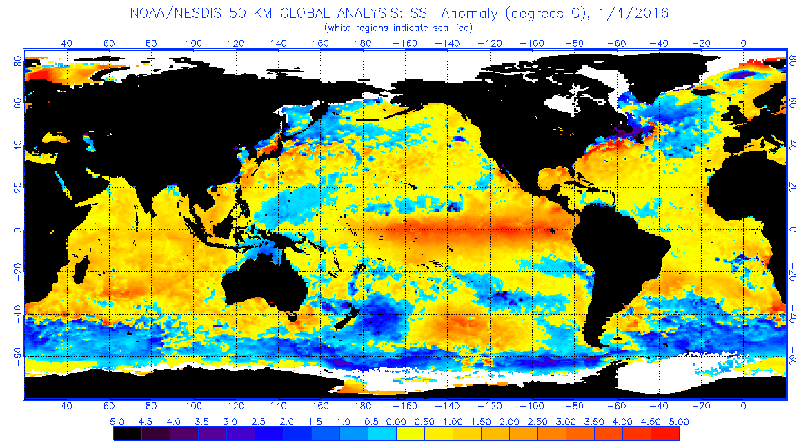
I quite like Mr Laminate Floor's chutzpah (when he's talking about weather anyway), but why are the North Atlantic SSTs key now, but not during the record mild of December? We had a persistent large Atlantic high during late summer, and a persistent Atlantic trough during December, yet the SST anomaly has been more or less the same throughout. On that evidence they make little difference, or at least are easily overridden by larger atmospheric patterns.
I suspect it has something to do with the Enso pattern be a full basin pattern in the early winter - overriding any Atlantic signal, but since then I believe it's begun to weaken somewhat (most especially in the eastern side - enso 1/2) - so that it's becoming more Nino Modaki -
http://www.bom.gov.au/climate/enso/
and the Atlantic signal can come into play a bit more. That said, the Met Office (I think) were more of the view that the Atlantic signal favoured a positive NAO - and I don't really see a tripole in the current anomalies.
Maybe if there's someone here that's a member of Weatherbell - they might be able to comment? Another thing to notice in the SSTA profile is the PDO pattern is just beginning to shows signs of heading negative again (same thing happened in the late 1950s - it switched positive for a couple of years, before plunging).
-
1
-
-
- Popular Post
Thought this was interesting - Joe B thinks we're now approaching the same point in the Enso cycle that coincided with the cold period in the 09/10 winter and can expect similar results for Europe as a whole.
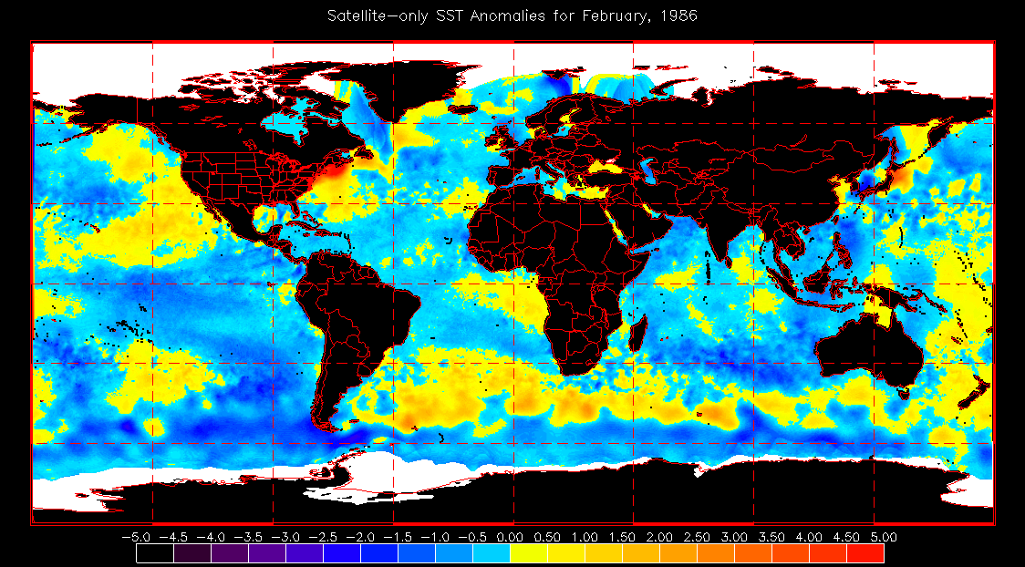
I think there's a chance that this could ultimately end up a bit like Feb 83 (also a strong El Nino winter)
http://www.meteociel.fr/modeles/ecmwf.php?ech=192&mode=1&map=1&type=0&archive=0
http://www.meteociel.fr/modeles/archives/archives.php?day=6&month=2&year=1983&hour=0&map=5&mode=0
-
12
-
12 minutes ago, KTtom said:
One little point I'm struggling to understand, the low off eastern Canada looks perfectly alligned to me to pump WAA up western Greenland, yet the high is struggling to ridge far north, yet past experiance tells me it should be lacating to Greenland ??
I think that part of the problem is the existing depth of cold over Greenland making it hard for WAA to push that away - if it's to happen, it could need a couple of attempts as per last night's ECM I think. We've also got the core of the upper level stratospheric vortex smack bang over the top of Greenland on the 6z.
http://www.meteociel.fr/modeles/gfse_cartes.php?&ech=210&mode=10&carte=1
-
2
-
-
I would imagine that exactly the same would have happened if squirrels were the most advanced life form on the planet, and I also expect the Paris summit to prove that they are.
Am I going to jail?
Seriously when you get to my age and you've seen various 'scare' storied peddled by media, politicians and various scientists over the years - only for them to amount to nothing, you get very sceptical when you see media and politicians jumping on a bandwagon and refusing to listen to anything that doesn't agree with their position. When that happens, experience tells me the opposite is nearly always closer to the truth.
-
2
-
-
http://www.weatherbell.com/saturday-summary-october-31-2015
I recommend listening to this from around 1m 40 - if you're interested in the likely upstream tropospheric patterns from this el nino as we go through winter - which may of course have an impact on what evolves in the stratosphere. There's big differences to 1997.
-
3
-
-
I would say this was spot on for the UK - failed to capture just how hot Europe would be.
The runs are all archived in this link; have a look back.
http://www.metoffice.gov.uk/research/climate/seasonal-to-decadal/gpc-outlooks/ens-mean
To be pedantic
it shows a lot of England as above average temperature wise - but in reality it was colder than average (at least relative to the 1961-1990 period) during that period.http://www.metoffice.gov.uk/hadobs/hadcet/cet_info_mean.html
-
1
-
-
"Winters are definitely not getting worse here - maybe they are getting worse in the Midlands and southern England. "
Don't think so we had a few cracking winter spells in recent years Feb 2009, Dec 2009, Jan 2010, Dec 2010, Feb 2012, Jan 2013. The last 2 winters have been rubbish - but this is the UK and we're never going to get cold every year. Even in the height of the LIA, there were mild winters. :-)
The run from 1995-2007 though was atrocious - so it's been better in the last decade if anything.
-
4
-
-
The AMO cycle has been known about for years and was due based on past cycle lengths to be be moving into its cold phase around now. Personally, I'd expect a brief warming over the next 12 months in response to the large El Niño, before we see the real switch in 2017; that's just gut feel though. Anyway, given it's a long term, acknowledged cycle, which is behaving as would be expected, whatever the cause of the move into the cold phase, it's very unlikely to be global warming - in case anyone is thinking that.
-
3
-


 it shows a lot of England as above average temperature wise - but in reality it was colder than average (at least relative to the 1961-1990 period) during that period.
Model Output Discussions 06z 04/11/16
in Forecast Model Discussion
Posted · Edited by beng
I guess the core of the upper heights are too far West (Canada rather than Greenland) for perfection in this run which is opening the door to that - especially when coupled with the still warm sea temps