


beng
-
Posts
497 -
Joined
-
Last visited
Content Type
Forums
Blogs
Gallery
Events
Learn About Weather and Meteorology
Community guides
Posts posted by beng
-
-
Here's a reanalysis of the Nov 1962 SST anomalies (below - bottom) - the standout thing for the Atlantic is the big cold anomaly to our SW - which no doubt helped encourage jet stream splits and troughing into Europe during the winter months. The anomaly in the Pacific is also of interest with cold water south of Alaska and then warm water (relative to average) right on the US W coast - which I'd think would favour a US/Canada West coast ridge to pump warmth up into the Arctic.
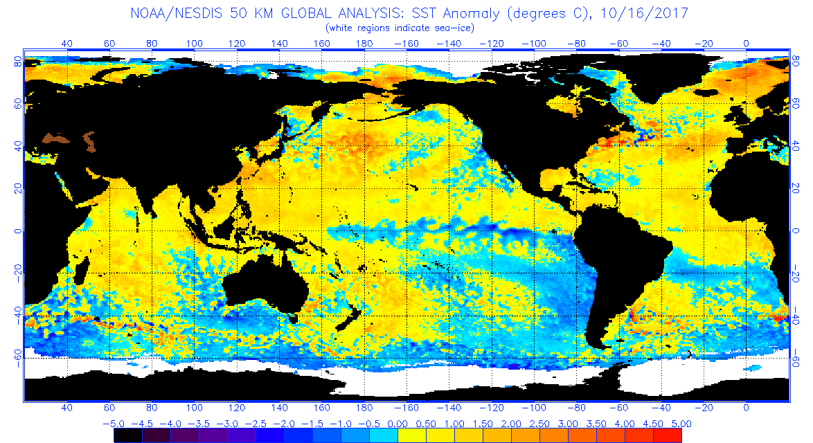
Looking at SST right now -

It's almost the opposite in terms of the 2 anomalies I described. Based off these, the implication is that we're looking at US West coast troughing and ridging on the US East Cast and potentially mild winter for W Europe - not what we want to hear. As we know, SST are just one factor though and do change quite considerably through Oct/Nov as Atlantic storms churn the ocean - so any forecast based off these ought to wait a couple of months.
1962 Nov, SST Anomalies
-
 1
1
-
-
2 hours ago, nick sussex said:
Overall the models all trending the same way but the set up of the block is now the issue. I think I remember something similar to the ECM output in Feb 2012 where the deep cold moved in that direction forming a shortwave and running nw not west.
What we want to see is not an extension of the ridge from the east with high centre over Russia but the main centre over Scandi, that's the main difference with todays ECM compared with yesterday evenings.
The orientation and exactly where any blocking sets up is still open to changes.
Yes this is the 2012 one - as you say the problem here was partly because the high wasn't centred over Scandi but too far East etc.
-
1
-
-
18 minutes ago, bluearmy said:
Just a note to some of you chasing the deepest cold pool - if you want a -11/-15 chunk of uppers to get here then you don't want to see a segment of vortex around -16/-20c hurtling west towards the North Sea - it won't get here as a shortwave will develop ahead of it as it reaches the sea and it will deflect north west
to advert that pool which would bring decent snowfall (-10/-15c) you need a cold pool to bleed off that really cold segment and advert west preferably across the land mass rather than the baltic and North Sea as that will also moderate those uppers.
it really is a tightrope walk to get that cold enough cold pool this far
to avoid confusion re cold pools - whilst we are also thinking about uppers, best to view them on the heights charts as those cut off blue/purple areas rotating clockwise around the blocking.
the ecm op run this morning a great example of how the cold pool can't get west beyond Norway as it hits the North Sea and the 06z gfs a great example of the safest way to get the cold pool this far as it heads west across Germany and the Low Countries with a short sea track to get here
Yes agree completely - Feb 1991 came through Ukraine and then across the continent. Maybe Jan 87 would be an exception as it looks like it came across the Baltic/N Sea more - but I just think we got amazingly lucky there with the trigger low interacting at the exact time frame to send it our way; any slight deviation and the cold would probably never have arrived in the UK on the scale that it did.
-
1
-
-
1 hour ago, bluearmy said:
eps in that 9/12 day period remain important - will they continue to head towards west based neg NAO with mildest sou'wester across nw Europe or can we get some features established in that few days which will put the northern arm on a different track.
Judging by the winter so far and the desire for that high pressure slug to our South or South West, I know where I'd put my money - of course that might not happen, but the pattern of Dec and early Jan does rather imply that the underlying ocean & atmospheric anomalies currently favour it.
-
1
-
-
6 minutes ago, colonelks said:
Biggin Hill is at a standstill!
https://m.facebook.com/groups/321110434672269?view=permalink&id=1159416404174997&ref=bookmarks
Drove home from work over Boxhill just before 5pm and it was getting pretty bad up there - imagine it's similar to that video by now.
-
2
-
-
2 minutes ago, Southender said:
If true that is ridiculous.
Suspect they will use it as an argument that they need the extra runway - probably been driven more by politics than weather IMHO.
-
1
-
-
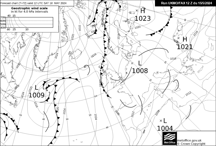
I wonder if we could get the polar vortex displaced as far as this? Probably not, but it does provide an excuse to post a nice chart
-
6
-
-
http://www.meteociel.fr/modeles/ukmo2.php?nh=1&ech=144&carte=1021
UKMO not great IMO - as I see it, the low to the NW is going to follow the jet around the high towards Scandinavia and prevent any further amplification.
-
2
-
-
http://www.meteociel.fr/modeles/gfse_cartes.php?&ech=162&mode=0&carte=1
Be good to see a bit of trough disruption west of the block too - GFS as normal at this range having none of it.
-
I know the higher resolution view won't look quite as good - but still this looks nice. If only it would stall like this for a few extra hours.
-
3
-
-
4 minutes ago, Pembroke Dangler said:
No I think it's the one to the west of the outer Hebrides see the kink in th me isobars if at flows south could develope into a small low (not the polar) kind could be mixed rain/sleet/snow due to warm sectors etc
Don't think so as he's referring to Thursday and says Northern extent not certain. :-)
-
13 minutes ago, bluearmy said:
Very interesting control brings the easterly and then retrogresses the ridge to mid Atlantic/griceland - euro upper trough expands nw. Then broad scandi trough (not deep) expands sw. cold to frigid throughout
jet drops split flow to our sw days 10/12.
southern arm stays strong throughout into the med.
not completely out of sync with the mean/anomoly
https://mobile.twitter.com/BigJoeBastardi/status/818438598835970048
Maybe some support for that from the forecast strat at 30 hPa?
-
3
-
-
Just now, snowking said:
A near triple-point (not entirely sure what the correct term would be there) across the 528dam boundary from an Atlantic flow with an uncertain trajectory...for a forecaster, what could possibly go wrong
Yes the MO must love that - ha ha.
-
The wave that Ian Ferguson was referring to is I suspect, the system in the channel on the latest 72h fax
-
9
-
-
42 minutes ago, Nick F said:
Can't see any trough disruption to the west myself? The trough looks too positively tilted for disruption. Looks like the ridge over the UK may nose further east like GFS though.
Seems to be a general theme for the GFS over last several runs and UKMO over last few runs for the Azores high to ridge in after the cold NWly later this week, and for many parts to become dry and cool and frosty at night, while the NW is prone to a milder SWly flow with Atlantic fronts bringing rain.
The Azores high ridging NE is no good for getting a Scandi high and easterly when there's so much jet energy piling NE between Iceland and Scotland anyway.
00z ECM was trending down a similar route, so perhaps finally we will have some agreement this evening in the medium range unless 12z ECM wants to make more of high pressure to the NE.
Trough disruption might be the wrong term, but if you look closely some of the energy is heading south with yes a fair chunk going NE, more going South than GFS. I didn't suggest a scandi high was on the cards from that, but I do think you end up with a cold block to the East and a continental flow of sorts into parts of the UK. Hopefully someone will post that 168h chart so where can see how it turns out :-)
-
http://www.meteociel.fr/modeles/ukmo2.php?nh=1&ech=144&carte=1021
I like the UKMO 144 chart - bit of trough disruption to our West - 168h might develop a decent cold block to the East - maybe not enough amplitude for a proper Easterly though.
-
Something that caught my eye somewhat is that this morning's ECM is the first morning ECM run to bring the Easterly on the Op; the previous times were both on the 12z Op run. Whether we can deduce much from that though, I'm not sure without knowing the reason that the 12z runs appear to have been more amplified up until now.
-
15 minutes ago, johnholmes said:
Other than the suggestion of December 2010 has anyone an idea what year this did happen please? It may have been Dec 2010 but that deep long lasting cold had been well sing posted by the anomaly charts and UK Met for two weeks or more before its onset in late November.
From that description John, then it would definitely be Nov/Dec 2010 - I remember both the Met and the stratosphere boffins getting very excited before it all hit.
-
28 minutes ago, snow1975 said:
According to BigJoeBastardi SST anomalies in the Pacific are similar to Dec 1983. The so-called 'Polar Vortex' will make an appearance across the Midwest this week, similar to Dec 1983, but not quite as extreme.
Joe has hinted that he favours a more negative AO/NAO through Jan though which would be different to Jan 84.
https://mobile.twitter.com/BigJoeBastardi/status/807738199107862529
-
20 minutes ago, Seasonality said:
Now the second chart is a true Bartlett from the winter of foulness that was 88/89, high pressure centred on and covering most of Europe..
that's 1998
-
32 minutes ago, bluearmy said:
If you had access to the ECM data you would be less disappointed- I did post that the ECM AO forecasts were much less excitable than the GEFS. As far as the NAO is concerned, forecasting the pressure patterns in the North Atlantic is even more unpredictable although again , ECM eps data has proved more reliable to our west.
The current ECM looks favourable for an attempt at an easterly after 168 hours (annoyingly the op doesn't go on to show it though) - could you let us know if a few of the EPS go on to deliver? Seems like there's a growing possibility of a mid month attack from the East - which would chime with Stuart's hints from a few days ago and something you mentioned too I think. The main issue with easterlies is that they are even more of a nightmare for the models than Greenland highs!
-
1
-
-
3 minutes ago, bluearmy said:
I NEVER POSTED NO UPPER COLD
its amazing how one persons interpretation of a post can become fact!
For the record, December doesn't look particularly dry on the para aside from a couple of weeks nw Scotland and week approaching xmas w uk
Good thing the Daily Express didn't read what you wrote
-
5 minutes ago, Ravelin said:
I've always thought myself that this winter may be more of the 'colder and direr' variety than snowmageddon. If I'm right though it'll be more luck than ability.
You might be right - but if we get a negative NAO combined with a negative AO, the chances that deep cold air will find its way towards are much higher than with just a standard block in the atlantic and a positive AO.
-
3
-
-
18 minutes ago, Glacier Point said:
That allows for the controlling influence of the Canadian ridge to be negated downstream. With the pattern of tropical convective rainfall beginning to creep back towards the Maritime Continent (non-MJO component), this suggest mid Atlantic / possibly Barents Sea / Scandinavia area modest ridge development. These won't be too obvious on week 2 means or even spreads, but small scale mid to high latitude ridges developing within a flow which is well displaced of its norm would be interesting.
Within this context, stratospheric warming impacts will be around the week 3 / week 4 periods. The tell tale signature for vortex splits is very cold 850 values pouring into NW Russia and Northern Scandinavia. Helsinki, Moscow and Murmansk the locations to keep an eye on for extended range ensembles. Some twitching of ensembles for these locations staring to occur but nothing stark just yet.
Intriguing times.
So sounds like there's some support (maybe not the right word at this range) at the moment for a potential easterly mid Dec that might be quite potent given the cold pooling that could be in place should it occur. I might have to look away from the models in the run up given the inevitable dramas around Easterlies! :-)
-
1
-


Where have the long fetch northerlies gone?
in Spring Weather Discussion
Posted · Edited by beng
It was the late 1980s when the AMO began to shift into its warm phase (I'm sure the run of warmer winters afterwards is no coincidence) - I think it's beginning to shift back into the cold phase right now, so perhaps not too much longer to wait for some better winters + we have the solar minimum coming. Colder winters tend to occur just after minimum (obvious exceptions aside) - perhaps because the ocean surface anomaly patterns (resulting from zonality over the previous winter seasons) initially fight the atmospheric pattern (more favoured to blocking during the minimum).
I have a theory (never had time to do the research to validate though) that proper easterly outbreaks are much less likely to get as far as the UK during the the warm AMO - partly because of the warmer N Sea, which increases the chances that shortwaves form and prevent the real cold from arriving, especially down here. Another theory is that when the pattern shifts into the cold AMO phase again, it will coincide with a notably cold W European winter during the switch; that should at least get tested in the next decade.