


Nick L
-
Posts
22,786 -
Joined
-
Last visited
-
Days Won
41
Content Type
Forums
Blogs
Gallery
Events
Learn About Weather and Meteorology
Community guides
Posts posted by Nick L
-
-
Some of the comments on the TORRO Facebook page are ridiculous. Suggesting it's a low end EF4!!! If it was EF4 the houses wouldn't even be there.
I've seen the collapsed wall. I think EF2 is more sensible. But 160mph winds? No.
-
 1
1
-
-
12 hours ago, Jo Farrow said:
@Fitzwis posted some photos from the scene a few days ago, see below. There were more.
https://www.torro.org.uk/pdf/20231106_TORRO_PressRelease_JerseyTornado.pdf
https://www.torro.org.uk/research/tornadoes/tscale
https://www.weather.gov/tae/ef_scale

Certainly not EF3 level if that was amongst the worst damage. For comparison, just Google "EF3 damage", simply no comparison.
-
1 hour ago, WeatherArc said:
I did think it was a little much but not sure how these things work, maybe to do with construction? I believe the ESSL gave it an IS2/EF2.
This is the worst damage ive seen, will have a look at twitter for anything else.
That's more like what I would expect. Perhaps some of the surveying of the rural damage has uncovered some debarking of trees? Shame that TORRO has released precious little evidence to back up the preliminary report.
-
Absolutely no way was that tornado worse than the Birmingham one! Either that or TORRO are yet to release proof of it.
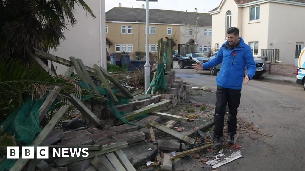
I've seen damage from EF-3 tornadoes close up and they do a damn sight more damage than rip off a few tiles. For comparison, this was an aerial shot of the Birmingham tornado which ripped roofs clean off and turned over cars:
And the aerial footage of the Jersey one:
At the scene where a 'tornado' struck Jersey
WWW.BBC.CO.UK
The BBC's Dan Johnson surveys the damage after Storm Ciarán struck St Clement.The damage in the footage doesn't correspond to TORRO's own scale for a T6:
"Moderately devastating"? Come off it. Happy to change my mind if someone can provide images proving me wrong but so far this just seems like TORRO overhyping things.
-
4
-
-
163mm for October around here, crazy amounts for Buckinghamshire.
Can we please, please, please have some crisp, cold, frosty weather? This wet and mild mush is becoming tiresome.
-
2
-
 1
1
-
-
7 minutes ago, daveinSB said:
There's a yellow warning for the south east, unless it's been cancelled?
It's for a tiny portion of the area likely to be affected, I simply don't understand why that small area has been included and not other areas which look to be just as badly if not worse affected. Every single model has the majority of the southern half of England seeing 30-50mm at least.
One of the major flaws in the way that the Met Office do warnings is that they have a window between 10-11am where they issue warnings and then very rarely make updates outside of those hours.
-
1
-
-
2 minutes ago, Rammie said:
We did have a warning, but I think it was cancelled.
There's been nothing for Friday yet, models have only come to agreement over last night.
-
Really should be warnings out for central, southern and eastern England for Friday IMO. Really quite a nasty rain event possible, soils will be saturated over the next couple of days.
-
7
-
-
What is that!
-
2
-
-
Just now, richie3846 said:
I'd think they'll also issue southern England - Friday now has substantial rain, further West than was thought yesterday
Indeed. I do forecasts for Network Rail and it's all hands on deck updating them this morning. Could see 50mm through London and the SE. Should be warned IMO.
-
2
-
-
...surely they're about to issue something for NE England at the very least?
-
A weirdly small area.
-
1
-
1
-
 1
1
-
-
We went to Fuerteventura the first week of October, the same place we went last July. It was hotter than when we went in July. Remarkable heat and humidity, even with periods of Saharan dust diluting the sunlight.
-
2
-
1
-
-
1 hour ago, Met4Cast said:
I'm told guidance is about to be escalated to amber..
I'm hearing it may well be beyond amber tomorrow for rainfall in E Scotland.
-
2
-
1
-
-
It also made me laugh that the BBC weather article on this storm had to include a bit on how to pronounce the name. It's not exactly a ringing endorsement of the system if you're having to do that. I get that we're sharing the system with other countries who have their own names, but if there's doubt that the general population aren't even going to be able to pronounce the name then that has to raise doubts over this system.
-
6
-
-
Put it on for the first time yesterday, a whole month earlier than last year. Got down to 14.1C in the end

-
2
-
-
There isn't even one defined area of low pressure for the unsettled spell, it's a series of secondary lows as far as I can tell. One of the many issues I have with this naming system is that it's almost impossible to define.
-
1 minute ago, Weather-history said:
I thought low pressures were named for wind strengths?
Indeed. I like how their Tweet says "strong winds will accompany this storm". That's similar to saying "snow will accompany the blizzard".
-
2
-
-
3 minutes ago, Sunny76 said:
Cloud can equal humid, but humid can also feel cold if you are by the sea or under rainy conditions for longer periods.
Yeah, but it was a below par month for sunshine where I was.
No it wasn't. It was average in London. By definition that is not below par!!
-
4
-
-
- Popular Post
- Popular Post
1 minute ago, Sunny76 said:No, it’s not inaccurate. It felt cool windy and was definitely cloudy. An awful period of high summer weather.
This is the problem with people's perceptions and memories, they're all too often wrong!
-
10
-
1 hour ago, In Absence of True Seasons said:
If we didn't have this September heatwave, the only 30c that would've been achieved this year would've been in June...
We have hot weather for a week and people lose their minds, overlooking the fact that it was cool, cloudy and wet for most the preceeding 6/7 weeks!
But it wasn't. August comprised "most of the preceding 6-7 weeks". Let's look at the stats:
Average for most, not cool, and warmer in Scotland:
For the vast majority, August was average or slightly drier than average:
For the majority of the population, it had normal amounts of sunshine, although sympathies for those in Wales and the SW:
But cooler, wetter and duller for "most of the last 6-7 weeks"? It's simply an inaccurate statement.
-
6
-
2
-
-
39 minutes ago, The PIT said:
It's impressive how awarm it is today despite the high cloud making it very hazy. If the cloud wasn't there it would probably be around 28C now rather than 25C
Humidity is both impressive and oppressive too, we're pushing 20C dew points here.
-
1
-
-
36 minutes ago, SqueakheartLW said:
Could the 36C September max temp record be under threat now. Never thought that was going to be on
Not sure we will get anywhere near that, 32-33 tops. Will be more the longevity of the 30C+ heat that's noteworthy.
Meanwhile, very frustrating to have the heat and humidity and this neck of the woods is unlikely to get much/any reward in the form of thunderstorms!
-
1
-
-
Spoke too soon about unpleasant heat being difficult to achieve in September. Been up in Glasgow the last few days for work and was having to wear a suit doing a training course in a south-facing room with no air conditioning - horrendous.
-
5
-


Storm Ciarán
in Storms & Severe Weather
Posted
I know Paul so have refrained from commenting on TORRO's page. But that's not helping the confusion, really.