


johnholmes
-
Posts
22,974 -
Joined
-
Last visited
-
Days Won
84
Content Type
Forums
Blogs
Gallery
Events
Learn About Weather and Meteorology
Community guides
Posts posted by johnholmes
-
-
hefty showers and a noticeable breeze with sunny spells, the day max of 7.2C is the coldest day here since 20 February!
-
 1
1
-
-
Dry with a fair amount of cloud and a low of 4.8C, as Pit posts=the lowest for quite a while; in fact a quick scan shows since last month.
-
Good morning all, could someone a lot more knowledgeable than myself post as to what the region is possibly looking at over the weekend, weather wise please, was hoping to take the kids to Donna nook either this weekend or the weekend after to see the seals.

this weekend not a good idea with gale force N'ly for a time on Saturday, Sunday might be okay?
-
dry with fairly small amounts of cloud, trees swaying again, a low of 9.5C, so 4C above the average.
-
- Popular Post
- Popular Post
Most of the anomaly charts seem to be quite firm on the idea of a 3 trough 3 ridge northern hemisphere set up. This is often slow to break down, although minor shifts in positions of these major patterns can make quite a difference to surface weather in any location. For instance the UK. Just where will the main ridge-trough axis be say 5 days or more from now.
ECMWF-GFS
http://mp1.met.psu.edu/~fxg1/ECMWF_0z/hgtcomp.html
NOAA
http://www.cpc.noaa.gov/products/predictions/610day/500mb.php
NAEFS
http://www.meteociel.fr/modeles/naefs_cartes.php?code=0&ech=240&mode=0&map=1&runpara=
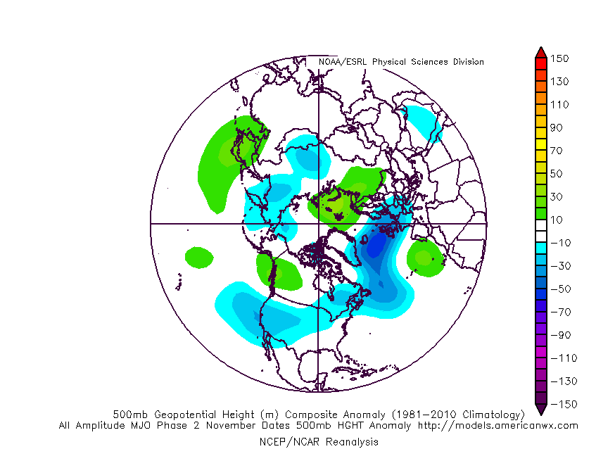
Is the MJO (GFS) any guide for this?
Currently in a low orbit showing 2 and predicted to show not much change other than a decreasing orbit value
2 equates in November to http://www.americanwx.com/raleighwx/MJO/MJO/NovemberPhase2all500mb.gif
and for December to http://www.americanwx.com/raleighwx/MJO/MJO/DecENMJOphase2all500mb.gif
So the flow of Pm air, sometimes rPM with not much of Tm seems the most likely into December to me?
-
11
-
Yes, this is factually correct. Anything else was from one or two "rogue" operational charts. Having said that the northerly on Friday/Saturday looks rather wintry up here with a decent chance of a good covering of snow even to low levels.
I wonder where 'up here' is? I have no idea of your nearest town so that comment is not much use to me I am afraid.
Please put your nearest town in your avatar ?
thank you
-
Gust to 58mph at the airport late last evening but almost calm here now, 3/4 cover CuSc Ac Ci and a low of 7.4C
-
13 December is the turning point for me. That's when the evenings start to get lighter here.
this table seems to suggest 19 December?
http://www.ukweathercams.co.uk/sunrise_sunset_times_by_month.php?id=13116&ts=1450460504
-
I know those NCEP guys like their jargon, but ...'SIGNIFICANT NORTHERN STREAM HIGH AMPLITUDE TROF AND SFC LOW REDEVELOPMENT'?
TROF (trough?), SFC?
you have to remember it written for other forecasters to read for guidance on producing their forecasts. A bit like the senior man summary at Exeter which we do not see.
-
Much as Meto monthly forecast. However, just like the upcoming cold northerly blast, these extended have a habit of not picking up on cold bursts.
I have to disagree with that. The anomaly charts regularly pick up 6-15 days ahead when a marked change of upper air pattern, a wavelength change is going to occur. This with careful use will indicate both bursts of tropical air in summer and cold air outbreaks in winter. They were slower than usual with this current one but did give perhaps 5 days maybe 7 of the upper air changing direction indicating colder weather developing.
see below for NOAA chart issued last Saturday, prior to that ECMWF-GFS had first hinted at this on the Thursday.
anomaly chart sat 14 nov for net wx.doc
sorry it has copied my whole November anomaly chart file, you will find it for Sat 14 nov if you scroll down
-
It will probably track out into the N Sea over NE England, north of Newcastle.
-
dry, mostly cloudy with a low early on of 8.5C
-
dry and fairly cloudy but some breaks giving a nice orange glow as the sun rises, mild with a low so far of 10.3C.
Very slight rain in the early hours=0.2mm
-
what do the last 2 paragraphs mean for the uk?cold or mild?
beware of trying to read too much into the NOAA daily assessments. Obviously they are top notch, their equivalent to our senior man at Exeter. But remember what they write is about their neck of the woods as is that from Exeter. Sadly, other than snippets from Fergie we have no access to a similar professional input as they do in America.
Watch the long wave patterns for hints of changes downwind into the Atlantic and western Europe/UK. It takes time to be confident in how to use them but it does give a decent insight into what the upper pattern, which is what largely governs the surface patterns evolving, may do in the 5-15 day period.
-
- Popular Post
Lets try and cut the sarcastic remarks, And just except we all enjoy different weather types. It's nothing new, And nobody has anything to prove as the weather will do what it wants at the end of the day.
So lets get back to respectfully ramping/moaning based around the models please. Cheers.
I've been on this site for 10 years or so. Yet I am still surprised by the amount of personal digs at folk. Heavens above we all came on here, I think, to start with because we love talking about the weather. It would be a deadly dull world if we all liked or disliked exactly the same things, weather or anything else. It IS going to get colder, by next weekend, some folk will see snow falling, some lucky ones (assuming you want this) will see snow lying. How long it will last is not yet clear. So why not enjoy and respect each other for not having the same views?
-
11
-
Cold north winds leaving Scotland by T180;
at 850mb, the surface values will be more relevant I would think for at least 1-3 days due to a surface high?
Might be wrong. It probably will mean the end of wintry showers though.
-
I am not sure what bias is in this context. Is it perhaps the difference NOT of the model to its past but more simply the ACTUAL heights for example as an average in November over x number of years. Not sure what time scale they would use, one sees 61-00 and others?
Ideas?
-
Yes but these were showing nothing like this a few days back!.
Just goes to show how quickly the weather can change
-
3
-
-
It is really interesting in some situations to see how much difference between say Pit, myself and PM in rainfall totals, bearing in mind accuracy, exposure etc. Last night very little rain here after 5.0mm during the day and you both show similar totals and it fits in for all 3 of us with the radar suggested totals.
The report from TM again reinforces the sharp distinction and possible rain shadow that is quite often a feature of this smallish area. I notice that stations SE and E of here reporting more than myself or one other about 4 miles NE of me.
delete that bit, just noticed he shows 18.2mm and we are usually within about 10% of one another!
-
1
-
-
Latest EC-GFS 500mb output, much as before with the cold look but notice that the upper ridge is being moved east so the deepest cold air is also moved east.
http://mp1.met.psu.edu/~fxg1/ECMWF_0z/hgtcomp.html
for comparison the NOAA 6-10 from last night below
http://www.cpc.noaa.gov/products/predictions/610day/500mb.php
and to see how another 500mb anomaly chart looks the NAEFS output last evening
http://www.meteociel.fr/modeles/naefs_cartes.php?code=0&ech=384&mode=0&map=1&runpara=
So for sure cold is coming but for how long is the question. Who will get snow, etc?
-
5
-
-
Dry, cloudy and fairly breezy after slight rain overnight. Very mild again, 9C higher than the lowest on Saturday morning; low of 14.2C. This is higher than the average low in any summer month. It sure will be a shock to the system when the cold air gets in!
-
NOAA has joined ECMWF-GFS 500mb anomaly charts with, see below, a noticeable ridge for the Greenland area and an equally noticeable trough east of the UK. It is only one output but it is rare for these 3 to be very similar and the pattern they are predicting not to occur. So nextweekend and possibly 3-5 days it would seem for a colder upper flow into the UK. Beyond that and a more westerly looks like being the pattern. That is based on the past 24 hours but it may change. As to how cold, when/where any snow then obviously that comes several days from now with the synoptic models.
CAUTION:- Do be aware that predicting anything falling from the sky is very difficult even 12 hours ahead, snow and you need to add about 6 possibly 8 more variables into the mix, obviously one of these is your height above sea level.
http://www.cpc.noaa.gov/products/predictions/610day/500mb.php
-
3
-
-
Quite disappointed with the lack of warning this severe weather is getting not even got its own thread!
what?
Try the front page, watch the regular updates by TV forecasters, go to the Met O web site. What more do you want. Even in the highly charged model thread, forever searching for cold there are charts and comments from folk about the amounts of rain predicted.
-
2
-
-
Picking up on the last sentence from phil
UK Met warning for designated areas, part of their text
I am not 100% sure but this amount of rain must be a very rare event even for the areas mentioned? 250 mm is 10 INCHES of rain!
This flow is expected to bring a period of heavy and persistent rain, with 50-100 mm of rain falling in many areas. However, as much as 200 to 250 mm may fall across some of the most exposed high ground.
-
9
-


Saturday 21st November General Weather Chat
in Weather reports
Posted
No snow here although it could have been sleet when it started around 0130 with the temperature low then on 0.8C, 1/2 cover Cu Sc Ci now and T=3.5C, 3.6mm since midnight. T the lowest since 27 April.
Plenty of snow shots on Derbyshire web cams.