


Severe Siberian icy blast
-
Posts
2,120 -
Joined
-
Last visited
Content Type
Forums
Blogs
Gallery
Events
Learn About Weather and Meteorology
Community guides
Posts posted by Severe Siberian icy blast
-
-
35 minutes ago, Mike Poole said:
ECM clusters, just one until T168, then we get 5 clusters T192-T240:

That there are 5 might suggest more uncertainty, but they are all variations on the same basic pattern. Clusters 1 and 5 fastest with the cold inside 10 days, the op is in cluster 1. Cluster 3 is the slowest, clusters 2 and 4 in between. You could perhaps make the case that cluster 1 is edging towards a west-based set-up.
I'd say cluster five is quite similar to the opp as in we do seem the struggle at first to rid the mid lat heights despite it moving towards Greenland there seems a lag of heights over the UK but it turns out great.
We're in a very very good position, early Jan, warnings above, background signals affirmative, Greenland high, undercutting, siberian/Scandinavia vortex!
Could be one to remember this year or am i still shell shocked from the 1947 channel five program the other night!
-
 5
5
-
-
3 minutes ago, Catacol said:
Evaporated? What - you mean like this rather interesting chart for 96 which will interest anyone on high ground
or this one for 24 hours later which will interest those in the far SE
or this one 24 hours later which may interest anyone on the east coast
then providing a 2 day window of hard frosts and falling temperatures before something rather interesting develops at 240h?
I really think perspective is required. We just don't get wall to wall white nirvana very often. In 3 days time the weather is going to turn colder and plenty of options are on the table. I'd take this morning's ECM run above 95% of runs from the last 15 years. Yes - yesterday was better and occasionally we have seen better over that time but anyone wanting more is going to end up with a very sore head, banging it against the wall so repeatedly!
Come on lad, we have a UK high on this morning runs and none of us can call it anything other.
If this moves 500 miles further north then yes we will have an easterly but the overnight trend is dropping it south not north.
Im not saying its curtains just saying how it is currently
-
1
-
 1
1
-
-
A definite trend for the high to sink a tad, but lets hope the initial lift can get the high pressure further north than this mornings model's predict,
The 0z are very often flat for which i have know explanation for but regardless of this all models have limited the northern limit of the initial high pressure lift off this morning runs.
Last night's runs were fun, and with some credence behind them too so i dont think it's a done deal yet but the envelope is closing.
-
1
-
-
1 hour ago, Snowmut said: If ever there was a chart to get you in the mood to watch the big snow of 47 on channel 5 tonight, that is it!

What time is this on!?
-
1 minute ago, Met4Cast said:
MOGREPS is actually broadly supportive if a more amplified high bringing in an easterly!
Some absolute peaches in those stamps
-
1
-
-
3 hours ago, Kasim Awan said:
Uppers don't matter much in a setup driven by evaporative cooling events and low heights.
A stiff westerly would be too much for that no?
-
- Popular Post
- Popular Post
The vortex is showing signs of moving toward Siberia and slowly draining away from Canada with tentative signs of high rises putting pressure on the vortex, linked to the Canadian warming few wks ago?
When we go through a period of zonality the models do tend to go into default at times effectively changing its entire output to dampen previous signals, ie mjo...
However i believe we're going to now start to go through changes within the model output which should slowly begin to play catch-up with previous signals.
If we can see positive mountain torque events over Asia which was the form horse aka direction of travel until recently when we've had - EAMT but showing tentative signs of reversing.
All to play for the next wk for me
-
10
-
50 minutes ago, bluearmy said:
Previous wording
It is possible that there will be further colder interludes, but these likely to be short lived at first. Perhaps a greater chance of a longer cold spell later in the period.
i’d say that today is an upgrade as more specific wordingI agree entirely, it's fascinating how we all read things according to how we choose to do at the time whether it be mood, emotions, it plays a part, but personally I'd say it's an upgrade comparing one another but best we dont hinge on every word its hard enough in winter in hear as it is

-
1
-
-
2 hours ago, bluearmy said:
GULP.......
I can not believe what i have just looked at
-
58 minutes ago, Mucka said:
GFS still very progressive with the Westerly regime but given the models now seem to be in agreement a Scandinavian ridge won't come into play in the mid term, then it is all eyes on the Atlantic again to see if we can get a substantial ridge and avoid a W based -NAO.
My original thought posted here were that any new blocking would be in the Atlantic sector and not over Scandinavia with the fear being that the Westerlies could win out entirely and we would enter a more sustained zonal spell.
The hope was that we could get some favourable developments earlier with the lows disrupting SE against the cold block, and although GFS has proved to be over progressive, that hope now seems to be over.
So now, barring a sudden change, our attention shifts back W and just beyond the mid term but certainly not deep FI so still plenty play for on whether we can resume blocking for mid month.
UKMO V GFS 144 (GFS extremely progressive but longwave not greatly dissimilar with both showing the trough to N of UK and potential Atlantic ridge behind.
Currently GFS, GEM, Icon all show the ridge attempt being overrun, so perhaps in deep FI a Scandi ridge could be the hope from any Atlantic amplification but for now I'll be hoping for upstream improvements and WAA into Greenland.
GEM
Not far away from good charts there. Once you have low pressure digging into Europe it opens the gap in the Atlantic up towards Iceland and Greenland for high pressure, and we all know what can happen then!
-
2
-
-
Evaporative cooling should play a part once the heavier stuff arrives
-
1
-
-
Yes its forecast to pep up now and pep up as it moves in land, anywhere from m4 north according to BBC but to be honest its a now cast situation, some may well be surprised tonight. Light winds and evaporative cooling can come to to play during marginal situations although today's temps there really shouldn't be anything marginal about it the wet bulb temp tonight is the tricky one.
All in all il probably be getting sent loads of pics from my bro @mark in brum and il have a sleet fest in wellesbourne Warwickshire but im hoping we all do well out of it
-
1
-
-
11 minutes ago, LRD said:
Look at all the other cobblers the Mail publishes too. And people are caught hook, line and sinker with it
MOGREPS with a much more solid looking signal for mild to win out this time next week. Similar looking signal in other places too... even in Aberdeen. Might not last long as some of the teleconnection-savvy folk on here are saying but it's there
You think that's a coherent signal for milder air? Disagree, its a flat line until the 7th for Aberdeen and then a 75/25% in favor or mild for now but it's as week away and you can see some of the members keep it freezing.
-
3
-
-
What a beautiful start to winter this is.
Its come through the back door this one we all know it. Hindsight is a wonderful thing to look back at and learn and develop but what we have now is not the normal set up and for ones that's new if you wanto learn honestly study through archive's and you will soon figure out all of the famous winters of the past
47/62/77(?)83/90/91 etc to more modern days of 09/10/13/18
95% of them is from charts like we're seeing now.
No assurances at all, the weather makes fools out of us all every day but time will tell if we can find the key to holy grail or its to become an incredibly frustrating near miss again!
-
6
-
-
25 minutes ago, bluearmy said:
The northern annular mode is another term for the arctic oscillation
the chart Dennis posted is looking at it through the whole atmosphere from the top of the strat to the surface
Down in the trop you can see that we are forecast to have a neg AO and even high up at the top of the strat there is a short lived reversal near to the pole
this is a gfs based forecast from the op run so whilst it’s likely to be fairly decent high up, down in the trop it could easily be wrong as the run heads through week 2
A great explanation there abit lazy on my part not do my research on this occasion but i have fifa on pause in a champions league semi final

I figured most of it out but what better place to ask a question in the best weather forum in the world
 ?!
?!
Thanks guys for all you're replies

-
2
-
 1
1
-
-
3 minutes ago, fromey said:
In the 15 years I ve been on here I’ve never been so hooked, will it slide, won’t it slide, east a bit west a bit! All I can say to any newbie on here is sit back and enjoy the ride!
this is the modern day Battle of Britain.
thanks to all for your input, keep it up
3 minutes ago, Dennis said:Good one NAM for things to come
Can you explain this please I'd like to understand this fully ? Thanks
-
34 minutes ago, Kirkcaldy Weather said:
Super watching as the feedback of progress from the cycle which has gave our pattern currently into the ongoing IO phases ie 2&3 with models starting to develop various tasty features
GFS op has been on the setup which is suggesting a negative PNA this has tendencies to pump high height developments over Scandi
That GEFS mean from 18z is prime feedback
Quite a few interest areas to watch VERY closely. Energy of most intense high heights transfers from Greenland and Canada to the Northeast and Scandinavia which links to a strong Pacific ridge - block. Trough over the Atlantic gradually becomes focused toward Canada parts of Greenland with negative tilt tendencies. Fairly significant outputs liking a severe and significantly intensifying cold pool with similar alignment with Feb 2018, PNA tendencies more into negative


A really informative post explaining the PNA pattern i actually found it really useful because i dont really know enough about it although seen it become a big player before.
I said days ago about an easterly its primed up for one!
-
1
-
-
2 minutes ago, That ECM said:
Sniffing something.

Well on the 06z it has surge of heights from southwest America driving north through Canada where as on the 12z it lowers heights substantially with a stronger vortex more compact which in turn gives us a stronger impact to the Western Atlantic so in theory this fits in better with the idea of stronger jet etc but we know wedges makes sledges but that's more of a beast out there but not impossible.

-
1
-
-
- Popular Post
- Popular Post
Wedges make sledges, and this is perfect for that, analysis of t180 hrs is pointless, I'd say any hint of sliders like on the icon, needs to be watched, the likelihood of a stronger block forcing energy under will be the theme of the the next WK in my opinion
-
11
-
1
-
1 hour ago, TSNWK said:
Thanks.. I was going to pose the question where to now after next weeks currently progged breakdown…which has broad support across the operations/ with the same trend showing in the clusters now…probably leading to a couple of weeks at least of mobility?
I’ve read thecteleconnections are postive for late December? Why should we believe them when they were wrong in summer and were not aligned to this current high pressure dominant chilly spell.
The say a day is long time politics.. Jeeze it’s a lifetime in model viewing

One morning of a breakdown been a wk away still and suddenly we're going into a two week period of zonality
 this place is hilarious.. we have had cross board agreement of very cold hair the last few days but now it's definitely right
-
7
-
-
54 minutes ago, Kasim Awan said:
We potentially have our first streamer interest - the Thames may come alive on Thursday as far as I can see 90% of hi res are in support of some Suffolk/Kent/Thames streamer action leading to the possibility of a good few cm inland due to nocturnal eradication of surface warmth. Also note a slight kink Wednesday Night /Thursday AM which looks to push into the North East, could produce a dusting inland as it moves in. These are speculations at present.
And thats our 5%
-
2
-
-
2 minutes ago, Downburst said:
This current setup is very much a disrupted Polar Vortex. As long as it's disrupted we are in the game. No question about it.
Exactly its alot like my friday nights walk home, lost, confused and looking for someone to warm me up
-
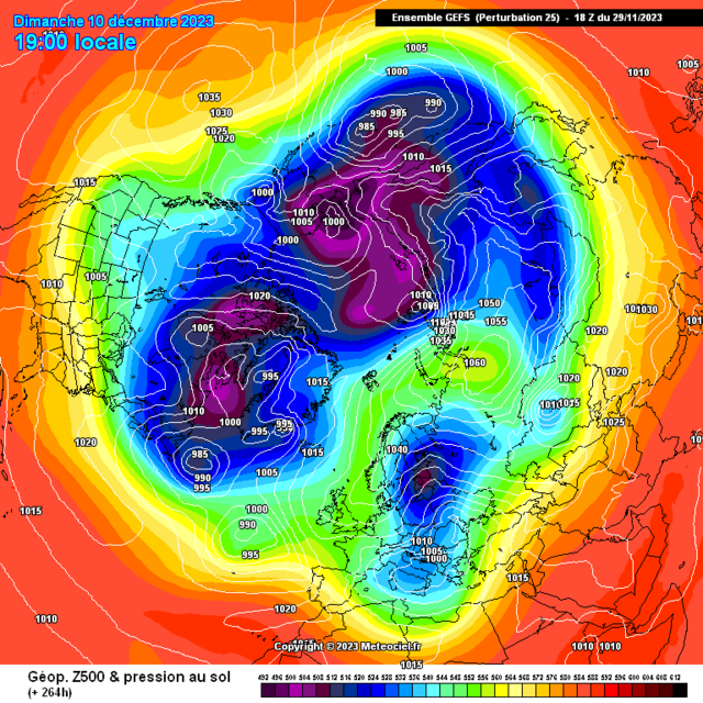
26 minutes ago, Cambrian said:
12z ECM op days 5-10 shows the potential outcome of maintaining such strong northern blocking for such a sustained period.
Keep your eyes on that little bubble of heights over the southeastern United States at day 5. Moves up through Newfoundland by day 8 then out over the Atlantic to meet the northern block at day 10. It’s actually quite a mobile setup - for the ridges! There is continual interaction with and feeding off the heights to the north.
The same wave of heights can be seen crossing the Atlantic on the 500 mb / MSLP chart, breaks through the upper trough hanging down over the western Atlantic, forming a surface high and pushing the cut-off low so far south it ends up south of the Azores.
This pumps up further heights into the forming high, and another wave of amplification heading up to our northwest towards Scandinavia.
In terms of the likelihood of something similar verifying, it’s probably not so much about particular pockets of heights and where they emerge on this specific run, perhaps rather that it’s symptomatic - in that the dice are so loaded from the outset by the northern blocking in favour of ultimately providing an evolution towards this type of outcome.
Yes you can see the wave interaction with the polar high pressure areas and how it strengthens them, i think as it moves way across the NH its going to interact with Siberia and produce a scandi, not saying we will get in on the action but high pressure to the north is the rule of thumb atm and the effects this can have moving forward is interesting to say the least! Most interested i've been in years!
-
4
-
-
17 minutes ago, Ali1977 said:
Interesting indeed


Model Output Discussion - Into 2024
in Forecast Model Discussion
Posted