


JamesL
-
Posts
327 -
Joined
-
Last visited
Content Type
Forums
Blogs
Gallery
Events
Learn About Weather and Meteorology
Community guides
Posts posted by JamesL
-
-
I'm quite liking the UKMO 144 chart. It wouldn't take much to see the 552 dam line appear just to the south of Greenland on the 168h chart

-
As much as the ECM has been meligned this winter (or certainly in the run up to this cold spell), you cannot deny its output 168h plus being fairly close to the mark for next week and certainly sniffing out the sinking high and mild SSE winds that come with it. In fact the GFS also was sniffing around this idea.
If you look generally at the models out to 144h (as that is the far reach of the UKMO) we will see that MOST of the output has been fairly consistent, even the verification stats back this up to a degree.
I have said before and I will say it again. Anything beyond 120-140h is purely to see trends emerging ESP in a situation that is not default (i.e. West to east/zonal)
Of course this MO discussion thread would be totally pointless and a potential bore fest if we were discussing weather that had a 90% chance of verifying (broad Synoptics) within that 120-140h timescale.
Some of the comments on this thread beggar belief. Almost as if the models are determining our weather! Lol
This winter here in the South Wales Valleys has been very dry (in the main), calm, more frosts than the last 3 winters put together and with 2-4 snowfalls (albeit above around 200m)
Its been a very untypical winter here and for me it's felt a little like those of yesteryear following an incredibly quiet, dry and calm autumn that actually saw our heaviest snowfall since 2013.
So lets enjoy the next 5 days and I prey that those of you that crave snow, see some at least falling. It doesn't matter how old you are (I'm 43), it never loses its magic and I still believe that we will see another bite of the cherry later this month and into March that will quench everyone's love for the white stuff
On a side note a HUGE thanks to BB1962-1963, Steve Murr, Blue Army, Tamara, Nick Sussex and others that make this forum such an interesting place for weather fanatics like me!
James
-
 4
4
-
-
- Popular Post
- Popular Post
Reading through today's posts I am in total disbelief at what I'm reading.
People have incredibly short memories.
Only 6 days ago this cold spell had next to no support from the Met and now we are staring down the barrel of 4-5 days of cold with snow in some locations.
Those looking a week ahead do so at their own peril. 7 days is a HUGE amount of time in weather terms.
Sit back, relax and enjoy the twists and turns that is model output.
This tweet from 6 days ago sums it up.
-
33
-
And also better alignment of flow too at t72
-
1
-
-
5 minutes ago, Ali1977 said:
ECM meanat 144 looks pretty good
Indeed and just 10 days ago there would have been incredible excitement if this was showing when we were staring down the barrel of Atlantic drivel for the next 10 days!
-
4
-
-
1 minute ago, Steve Murr said:
Morning
A lot of ECM lemmings here this morning -perhaps many missed last nights post showing that it has been terrible in the last 5 days - classic really in being over progressive...
let things develop- every day as things have got closer the uppers have got modelled colder - even the ECM has a pool of -9 air pushing SW into wales & the NW at day 5-6 yet people worried about day 8/9/10
so much flapping on here this morning the forums going to take off...
Hear hear Steve. I said in my post yesterday that I'm not really bothering about anything post 96-120h as the details are firming up every run.
We now have a Scandi high, let's see how it evolves. Fascinating viewing for me anyway even if everyone else looking way ahead in la la land
-
5
-
-
- Popular Post
- Popular Post
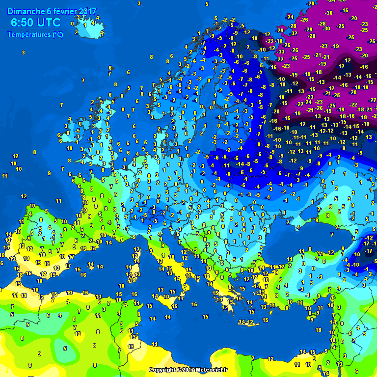
5 minutes ago, Bring Back1962-63 said:DAILY EUROPEAN TEMPERATURE AND PRESSURE CHECK No.3 – FURTHER EXCELLENT PROGRESS
In the build up to phase 1 of next week’s “probable” cold spell, I feel that it will be useful to keep up-to-date with the current and trending temperature and pressure changes in Europe. I will try to produce these on a daily basis for the next few days. This should help to show if the pattern is likely to evolve favourably (for coldies) and to monitor the extent of the cold that we might expect.
Now, I shall pick up from my first “check” on page 81. This took us to February 4th.
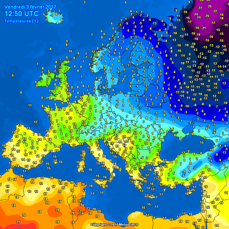
European Surface Temperature Charts:
Current "live" Feb 5th 0650 Feb 4th 1250 Feb 4th 0650 Feb 3rd 1250
Note that it is important to allow for min/max temps when comparing the charts. The 0650s are usually close to the minimums and the 1250s are usually close to maximums.
COMMENT: The good news is that the deep cold (purple) over north-west Russia is slowly intensifying and very importantly it is taking on a new “east-north-east to west-south-west shape - instead of north to south. The temps are slightly less low on the south side of the pool but lower to the north. It is edging slowly westwards. All this can be seen by comparing the two "0650" and the two "1250" charts. This is really important and a key area to watch over the next few days as the predicted synoptic pattern develops. Further south and west, the area of lighter blues is also becoming more extensive again
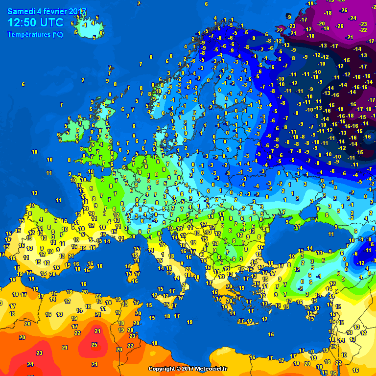
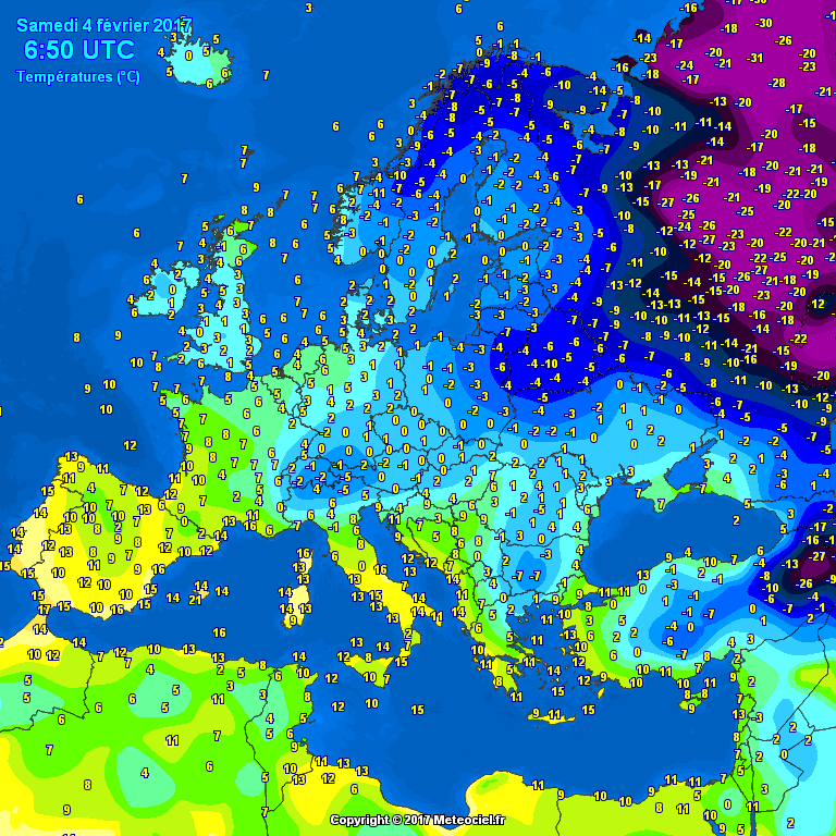
GFS 6z February 5th T+6 European Charts:
2m Surface Temps 850 Temps 500 hPa Temps
COMMENT: We can compare today's charts (above) with yesterday's (below). The surface temps in the purple shades has intensified with the area of sub -20c surface temps marching towards northern Scandinavia. The pool of sub -20c 850s has also expanded with a strong push towards Scandinavia. With the developing synoptic pattern (see below) this progression will almost certainly continue. The "green" warmer area to our north continues to be squeezed out and has almost disappeared.
GFS 6z February 4th T+6 European Charts:
2m Surface Temps 850 Temps 500 hPa Temps
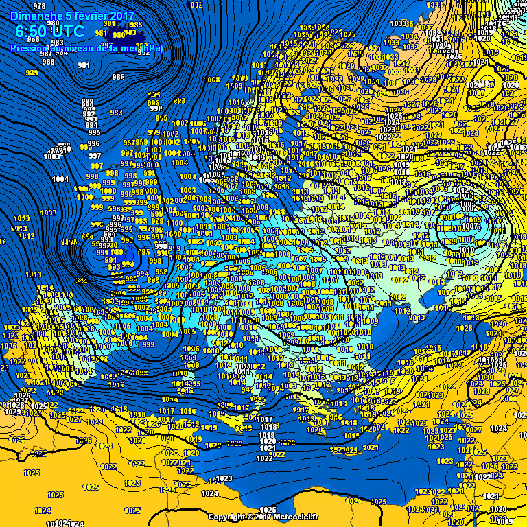
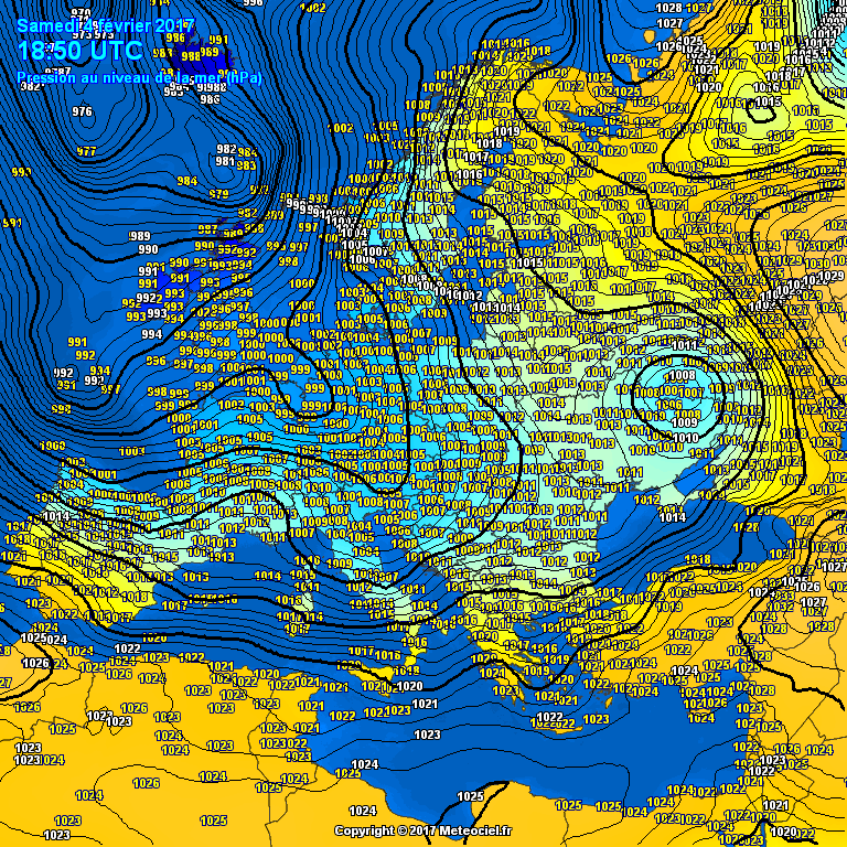
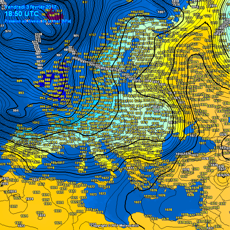
European Surface Pressure Charts:
Current "live” Feb 5th 0650 Feb 4th 1850 Feb 4th 0650
Current Met Office Fax: 0600 Feb 5th GFS 6z February 5th T+6 GFS 6z February 4th T+6
COMMENT: For the first time we can properly see the new cell of HP building down from north off the north-west Russian coast. It is ridging south-westwards into Scandinavia. The old southern cell of HP has been pushed further east. You can see the two LPs to the south already undercutting and supporting the HP block. All this bodes well for later on.
Overall, the building blocks are there and all of my indicators are moving in the right direction for coldies. The “easterly” is on its way! I will be back with my full weekly report this evening, which I shall thoroughly enjoy writing up during today.
It's fascinating watching this spell unfold in this way. Whether it ends up a damp squib or delivers snow, it's really interesting. And very useful for future pushes from the east.
Thank you for taking the time each day for doing these very informative posts.
James
-
20
-
Here's the 850 charts for same time and cold pool further west by 50-100 miles too
-
Alignment of flow on southern flank of HP already moved by around 3-5 degrees more favourably than the 6z
-
Much better alignment on the Jma akin to the Gem.
-
I for one am very pleased with where we are today.
Go back 5-7 days and see where we were! Staring down the barrel of a limpet PV and a succession of Atlantic driven drivel.
As TEITS alludes to, historically Scandinavian highs are notoriously difficult to pin down. Yes the general theme can be but the devil is in the detail even at 72-96hrs.
To have the general agreement on a theme 5-7 days out on ALL the NWP is VERY encouraging indeed.
Now the ens have smelled the coffee we can see the means are pretty impressive for the next 10 days. When have we had this kind of cross model agreement on this kind of "cold" setup?!? Probably not since 2010!
So for me I'm now looking within the 120h timeframe as anything else (regarding uppers, cold pools, instability etc) won't be resolved until 48/72h
James
-
4
-
-
I would almost bet my last pound coin that if this trend for westward corrections continues, next Thursdays potential battleground will just effect the SW of Ireland.
Historically, blocking is inderplayed and ends up further west with the Synoptics on offer currently.
Just my take on things right now.
-
1
-
-
To be fair to Steve he said 99%, so I guess he covered himself by the 1% He may of course still be correct but sadly it's looking less likely now
Eyes down for the 12z's now and we maybe slightly closer to resolving those small height rises to the north and the undercutting low scenarios
-
Probably the coldest in terms of penetrating frosts since 2010. Parts of the Kentish marshes are frozen solid with 4" ice, enough to walk on.
Imo a noteable cold spell, not just for the average temp but also for its lack of any appreciable rain/snowfall.
Anyway all change at the weekend now as the models move away from height rises around Iceland and undercutting lows and more towards an Mid Atlantic based air flow.
-
1
-
-
So while everyone has eyes on the next potential cold spell, we still have the potential for some light snowfall here in Wales over the next 24 hours. Low dew points and surface temps will be drawn in from the continent along with a little instability to produce snow flurries particularly overnight and into Thursday morning.
Im expecting nothing of significance but it will be nice to see.
One thing that has really struck me this autumn and winter is just how dry and calm this period has been. I can't remember two seasons being so void of "weather" in my lifetime.
A calm and generally warm blocked autumn leading into a coolish winter, again with blocked conditions prevailing. Yes we haven't had loads of snow but these two seasons have seen many frosts and two snow events for land over 200m. In fact the autumn of 2016 produced more frosts than the entire winter of 2015/16!
Im fairly confident that before the end of March we will see a more notable snowfall across Wales as there are tentative signs that the strat warming will encourage HLB rather than the MLB we have seen for months. Model output has been "volatile" this year with many "close but no cigar" events. It will just be a matter of time before we strike it lucky.
Lots to stay positive about in my opinion.
-
Yes we did in Cwmdare too, woke to snow at 4am. Then it turned to rain and drizzle.
-
- Popular Post
- Popular Post
Some photos from this morning up on the Rhigos between Hirwaun and Treherbert. Here we are around 480-500m asl
it was stunning with amazing views over the Brecon Beacons and beyond. The mountains had a good covering with the snow level at around 200m
we had a covering here in Cwmbach until it melted around 9am at around 120m asl, which tied in nicely with my forecast of around 100-150m getting a covering last night.
Depths varied between 1cm at 100m to around 10cm at 500m
James
-
10
-
Heavy snow shower just passed through Cwmbach leaving a covering.
-
1
-
-
As I mentioned earlier, showers are now aligning themselves into more organised bands.
Expect the unexpected especially if you get caught under one of these trains.
Moderate settling snow here in Cwmbach and it's been snowing for the last 30 minutes now.
-
1
-
-
Interest now starting to come from convection off the Irish Sea.
Dont be surprised if we see these showers merge later this evening and overnight into longer spells of snow esp above 100m
I don't think that anywhere is safe IMO
-
1
-
-
Some pics between Hirwaun and Treherbert
-
2
-
-
Up over towards trehebert from hirwaun it gets up to around 450-500m and snow is pretty thick and settling all over roads.
Wind has really got up now between Hirwaun and Merthyr with heavy blowing snow settling too.
Temperature around 0c here now at around 900-1000'
-
2
-
-
2 minutes ago, hmarkd1974 said:
anything up ystrad way at the moment? a few people here in work headed that way during rush hour laters
Just changed my profile (as not been on here for years) and now live in Cwmbach, Aberdare.
My wife informs me that we have falling snow at home which I'm guessing is around 150m asl
I would certainly think there would now be snow falling in Nelson at around 200m, as for Ystrad maybe but not setting yet.
-
Just driven over the top of Maerdy Mountain from Aberdare and moderate setting snow down to around 200m here now. Sleet in Aberdare town.
Cold air now cutting in under the rain band so maybe a few surprises thus afternoon, esp with a little height.
My interest lies in later tonight and early tomorrow once this system clears and we have the potential for some heavier snow showers down to sea level (although setting snow would be transient)
I think anywhere above 100-150m could well see a couple of inches by morning, coupled with some rather nasty road conditions, esp on untreated surfaces


Model output discussion 8th Feb - Cold for now, but then what?
in Forecast Model Discussion
Posted
I have a feeling that we may well be seeing a few more hints of cold from the north in 10 days time.
The ensembles toyed with them a day or so ago before dropping the theme but I've got a feeling the trend will be strengthened in the next few days giving us interest after this weekends cold.