


john pike
-
Posts
10,848 -
Joined
-
Last visited
-
Days Won
30
Content Type
Forums
Blogs
Gallery
Events
Learn About Weather and Meteorology
Community guides
Posts posted by john pike
-
-
http://www.wetterzentrale.de/pics/MT8_London_ens.png
9th-17th shows temperatures below average
warming up ?
-
http://www.meteociel.fr/modeles/gefs_cartes.php?code=9&ech=6&runpara=0&mode=1

http://www.meteociel.fr/modeles/gefs_cartes.php?code=9&ech=192&runpara=0&mode=1
a lot of very cold ensemble members tonight
http://www.wetterzentrale.de/pics/MT8_London_ens.png
9th to 15th cold enough for snow ?
certainly ensembles show enough precipitation
uppers are very close hovering between -5 to -10
if gfs is wrong with only 3 days to go that would
be remarkable
time will tell though
http://www.wetterzentrale.de/wz/pics/Recm1441.gif
http://www.wetterzentrale.de/wz/pics/Recm1681.gif
http://www.wetterzentrale.de/wz/pics/Recm1921.gif
http://www.wetterzentrale.de/wz/pics/Recm2161.gif
http://www.wetterzentrale.de/wz/pics/Recm2401.gif
ecmw run
-
18z gfs
http://91.121.84.31/modeles/gfs/archives/gfs-2011030518-0-102.png
http://91.121.84.31/modeles/gfs/archives/gfs-2011030518-0-126.png
http://91.121.84.31/modeles/gfs/archives/gfs-2011030518-0-150.png for snowy
http://91.121.84.31/modeles/gfs/archives/gfs-2011030518-0-174.png
http://91.121.84.31/modeles/gfs/archives/gfs-2011030418-0-228.png
still sticking to a colder outlook
http://www.meteociel.fr/modeles/gfse_cartes.php?ech=6&code=0&mode=1
http://www.meteociel.fr/modeles/ukmo2.php?ech=0&carte=2000
run the sequence and we should be under a north westerly
by thursday with what looks like a cold northerly to follow
http://www.meteociel.fr/modeles/gfse_cartes.php?mode=0&ech=204
276-312 again gfs special easterly then after that shows
possibilty of something warmer this is all fi at the moment though
hello yamkin nice 12z run
-
Hey don't take it personally John
You have to admit thought that the cold has been shown on the charts for an awful long time now but never appearing in the reliable time frame.
I think this Northerly for next week is probably the closest we have gotten since December but even that is still too far away to get excited about yet I fear.
hi jayces
only kidding myself
for what its worth the charts have been awful this year
and made attempting to forecast anything past 5 days impossible
however the only good thing about this northerly is gfs i feel
tends to be better at predicting northerlies rather than easterlies
the models have shown the colder spell for about 8 days now so
maybe a late winter blast?
lets try and work out what the 18z has to offer
-
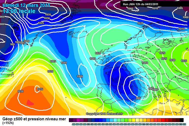
http://www.meteociel.fr/modeles/jma/archives/2011030412/J192-21.GIF
http://www.wetterzentrale.de/pics/MT8_London_ens.png
http://91.121.84.31/modeles/gfs/archives/gfs-2011030512-0-168.png
seems to me if you comment on what the charts are showing
people think you are ramping
maybe i will post charts and not comment
or maybe not
-
Gritters out here for second night in a row...currently 1c with the ol' weather station forecasting snow! Think it's become attuned to my weather wishes :lol:
:lol:
hopefully next week your weather station will be right
i reckon if the charts do not do a flip the site
could get busy again
http://www.meteociel.fr/modeles/gefs_cartes.php?code=17&ech=6&runpara=0&mode=0
http://www.meteociel.fr/modeles/gefs_cartes.php?code=17&ech=192&runpara=0&mode=0
http://www.wetterzentrale.de/pics/MT8_London_ens.png
run 17 with the big precipitation spike
mega run but this is only for fun
-
I'm very surprised with the MetO's latest forecasts over the next few days/weeks. Put it this way, Croydon Council have been TOLD to make sure their gritters are ready.
I wouldn't be surprised to see the MetO's forecasts change towards the GFS colder trend.
hello yamkin i am surprised too
although people think of the 18z as the pub run for
its wild swings,for the last 8 days the model has picked up
on this cold spell from the 9th with very good consistency.
i think in my opinion gfs is very good at predicting
northerlys so i have more confidence in this rather
than the failed easterly promises.
only time will tell though
-
http://www.meteociel.fr/modeles/jma/archives/2011030412/J192-21.GIF
just for snowydayz
http://www.meteociel.fr/cartes_obs/gens_display.php?ext=1&x=322&y=150
ensemble mean goes between -5 to -10
from the 9th to the 12th with precipitation
should be cold enough for snow
we are only talking 4 days away
hello yamkin i feel if we are showing what the models
are showing why not have a little ramp?
http://www.wetterzentrale.de/pics/MT8_London_ens.png
look better in this format
-
http://www.meteociel.fr/modeles/gfse_cartes.php?ech=204&code=0&mode=0
http://www.meteociel.fr/modeles/gfse_cartes.php?ech=204&code=0&mode=1
http://www.meteociel.fr/modeles/gfse_cartes.php?ech=204&code=0&mode=2
towards the end of the run gfs shows a customery easterly
one day maybe
-
http://91.121.84.31/modeles/gfs/archives/gfs-2011030418-0-120.png 9th
http://91.121.84.31/modeles/gfs/archives/gfs-2011030418-0-108.png
http://91.121.84.31/modeles/gfs/archives/gfs-2011030418-0-132.png 10th
http://91.121.84.31/modeles/gfs/archives/gfs-2011030418-1-132.png
http://91.121.84.31/modeles/gfs/archives/gfs-2011030418-0-150.png 11th
http://91.121.84.31/modeles/gfs/archives/gfs-2011030418-1-150.png
a selection of cold gfs 18z charts
http://www.meteociel.fr/modeles/ukmo2.php?carte=2000&ech=0
120 fax shohs 528 dam air over north of uk
a couple more frames of 120 should show the north westerly showing
and cold air covering the whole of the uk
sorry had to finish on a ramp
-
http://www.wetterzentrale.de/pics/MT8_London_ens.png
http://www.coaps.fsu.edu/~maue/extreme/gfs/current/raw_temp_c.html#picture
http://www.weathercharts.org/wetterzentraleGFSforecast.htm
cannot see anything warm on these at present
will update 18z later
http://91.121.84.31/modeles/gem/archives/2011030412/gem-0-138.png
http://www.meteociel.fr/modeles/jma/archives/2011030412/J144-21.GIF
http://www.meteociel.fr/cartes_obs/comp_panel.php?mode=0&ech=138&size=0
http://91.121.84.31/modeles/gfs/archives/gfs-2011030412-0-144.png
interesting how close these are
-
http://www.meteociel.fr/modeles/gefs_cartes.php?code=11&ech=252&mode=0&runpara=0
sorry but had to do this
now thats what i call a proper winter storm
-
http://www.meteociel.fr/modeles/ukmo2.php?carte=2000&ech=0
still high pressure all the way so dry and chilly
except a front on saturday night which could give some
light precipitation.
we may see some sun but will probably be mainly overcast
the 120 fax still shows the set up for a north westerly
later on but will come into view in 2-3 days
http://www.wetterzentrale.de/pics/Rtavn1261.png
http://www.wetterzentrale.de/pics/Rtavn1262.png
http://www.wetterzentrale.de/pics/Rtavn1264.png
http://www.wetterzentrale.de/pics/Rtavn1264.png
shows the northerly digging although not quite affecting the south east
http://www.wetterzentrale.de/pics/Rtavn2282.png
http://www.wetterzentrale.de/pics/Rtavn2284.png
http://www.wetterzentrale.de/pics/Rtavn22817.png
sunday 13th long way out but would give snow to us down here
http://www.wetterzentrale.de/pics/Rtavn30017.png
wednesday 16th again long way out but cold still
interesting from the 9th
also a lot of colder members showing again
looks even better here
http://www.wetterzentrale.de/pics/MT8_London_ens.png
mean temperature shows -5 on there
just need it a little lower and i will be more confident
of snow instead of sleety snow mix
-
http://www.meteociel.fr/cartes_obs/comp_panel.php?mode=0&ech=6&size=0
just thought i would post this
helps by showing how different some of the models
are in the same timeframe
will post later on the 18z and fax
-
Because we've seen this situation on the charts come to nothing all too often over the last couple of months, in saying that outlook does look good for both sun and frost
, just can't see snow happening though now.i understand that
however the charts seem to be unreliable chasing easterlies but
these are cold north westerlys and tend to be picked up
more reliably by the models (only my opinion)
http://www.wetterzentrale.de/wz/pics/Rjma1921.gif
still worth discussing though and we only have
to the 21st on here to do so.
http://www.wetterzentrale.de/pics/MT8_London_ens.png
certainly not dry from 9th onwards will it be cold enough for snow?
http://www.guardian.co.uk/uk/2010/mar/29/snow-forecast-british-summer-time this is for last year
nice to see you around yamkin
-
http://www.meteociel.fr/modeles/gfse_cartes.php?mode=1&ech=6
http://www.meteociel.fr/modeles/gfse_cartes.php?mode=1&ech=204
http://www.meteociel.fr/modeles/gfse_cartes.php?mode=0&ech=6
http://www.meteociel.fr/modeles/gfse_cartes.php?mode=0&ech=204
http://www.meteociel.fr/modeles/gfse_cartes.php?mode=5&ech=6
http://www.meteociel.fr/modeles/gfse_cartes.php?mode=5&ech=204
http://www.meteociel.fr/modeles/gfse_cartes.php?mode=2&ech=6
http://www.meteociel.fr/modeles/gfse_cartes.php?mode=2&ech=204
lot of links but these show colder air coming down to the south
from the 10th onwards with plenty of precipitation from a north
westerly flow
the jet stream has taken a more north west to south position which
should help let the colder air head more southerly
what we need to watch is the high pressure to our south west
if this stays fairly flat this will let the cold air reach us
if it builds and heads north it will deflect the colder uppers away
from us.
a long way out but could be interesting.
http://www.meteociel.fr/modeles/ecmwf.php
ecm 12z a similar pattern
http://www.meteociel.fr/modeles/ukmo2.php?carte=2000&ech=0
fax charts look similar up to 120 with cold up up north ready
to head towards us
i only guide from the fax charts so i will go to monday
with chilly-cold to monday
the is a weak front going over us saturday night so could be a
small risk of light sleet or very light snow
i am surprised to see it so quiet here
-
Has anyone seen the 12z GFS?
http://www.netweather.tv/gfsimages2/gfs.20110302/06/93/h850t850eu.png
Surely if this high moves north or west we'll be right on the money?
If it moves north we get a bitter easterly and if it moves west we get clobbered by a cold northerly? Both would bring back cold temps.
Anyone care to comment?
http://www.wetterzentrale.de/pics/MT8_London_ens.png
ensembles have picked up something around that day
only 24-48 hour but certainly is cold but dry
although that can change
http://www.wetterzentrale.de/pics/Rtavn2402.png
http://91.121.84.31/modeles/gfs/run/gfsnh-0-180.png?12
10th looks interesting
http://91.121.84.31/modeles/gfs/run/gfsnh-0-240.png?12
12th looks better
was that a ramp?
-
-
http://www.meteociel.fr/modeles/gfse_cartes.php?mode=0&ech=6
http://www.meteociel.fr/modeles/gfse_cartes.php?mode=1&ech=6
gfs very similar to ecm tonight
the jet stream is showing further south on the 18z against
the 12z which is allowing quite a strong nw flow
not the best location for the south east but it is a start
look at the temperatures further north west
still showing us losing the high pressure
around the 8th-9th on both models which will at least give
us some interesting weather.
http://www.meteociel.fr/modeles/ukmo2.php?carte=2000&ech=0
high pressure all the way to sunday so dry but a couple
of degrees higher than today but then feeling cooler
again sunday with a north easterly flow
http://www.meteociel.fr/cartes_obs/gens_display.php?ext=1&lat=51.29554655870445&lon=0
-
http://www.wetterzentrale.de/pics/MT8_London_ens.png
dry and chilly to the 9th
scatter afterwards but more colder options showing up
no sign on the ensembles of the atlantic powering through
-
http://www.wetterzentrale.de/wz/pics/Recm1921.gif
http://www.wetterzentrale.de/wz/pics/Recm2161.gif
http://www.wetterzentrale.de/wz/pics/Recm2401.gif
long way out but would at least give us some interest again
-
It looks as though I may have been a little premature - I believe the mods are planning on keeping the Regional discussions open until 21st March. Whether this brings any proper Wintery weather between now and then remains to be seen....
-
http://www.meteociel.fr/ukmo/fax/fax120s.gif
saturday chlly and dry
http://www.wetterzentrale.de/pics/MT8_London_ens.png
ensembles show dry to 9th
a few colder options showing 6th on for a few days
http://www.wetterzentrale.de/wz/pics/Rukm1201.gif
http://www.wetterzentrale.de/wz/pics/Rukm1441.gif
http://www.meteociel.fr/modeles/gefs_cartes.php?code=6&ech=6&runpara=0&mode=1
could be worth seeing where this high goes
been a good winter in december
shame about the rest
been nice talking to you all
you never know winter may bite back, probably when we all
give up looking for a cold spell
bye all for now
-
gfs is a warm outlier but dry
http://www.wetterzentrale.de/pics/MT8_London_ens.png
http://www.wetterzentrale.de/wz/pics/brack4.gif
cool and dry with the only excitement being some nightime frosts
look like high pressure until 9th
we could see some sleet tomorrow if showers
get heavy enough
i think the board maybe a bit quiet for a few days
sorry last day today its a shame we cannot have a last day rampede
be back late goodnight


London & South East England - The Yamkin Ramper Thread
in Spring Weather Discussion
Posted
http://www.wetterzentrale.de/pics/MT8_London_ens.png
messy ensembles
gfs run on the warmer side
kontrol run very cold
http://www.wetterzentrale.de/wz/pics/brack4.gif
120 fax shows 528 dam line moving southwards
look to the north of the uk
very cold northerlies there.
what will they show tomorrow?
i think i will reserve commenting until tomorrow night
as too many differences in the models