


john pike
-
Posts
10,848 -
Joined
-
Last visited
-
Days Won
30
Content Type
Forums
Blogs
Gallery
Events
Learn About Weather and Meteorology
Community guides
Posts posted by john pike
-
-
http://www.meteociel.fr/modeles/gfse_cartes.php?mode=0&ech=6
hear we go again :lol:

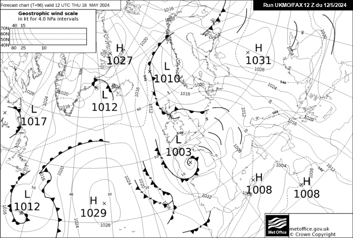
http://www.meteociel.fr/ukmo/fax/fax96s.gif
low pressure to our south east
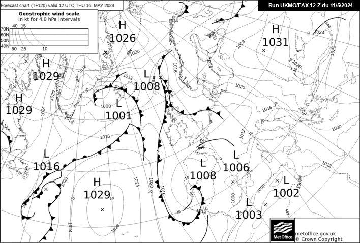
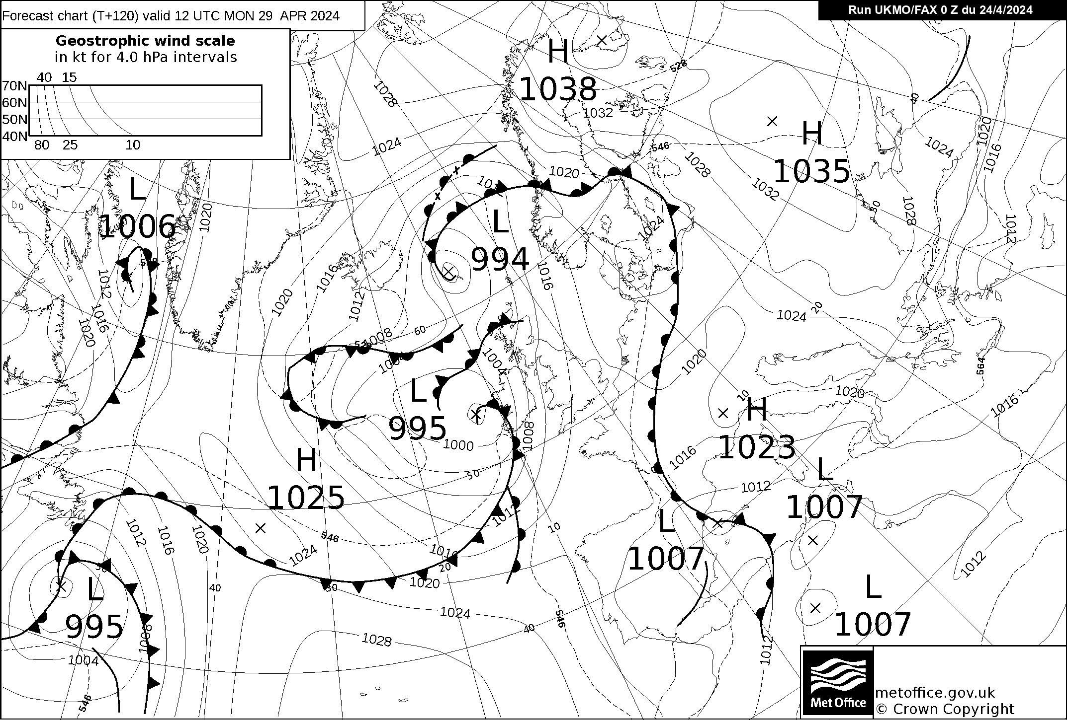
http://www.meteociel.fr/ukmo/fax/fax120s.gif
low pressure vanishes
http://www.weathercharts.org/wetterzentraleGFSforecast.htm
block holds stronger in these charts
gfs picking up on something
http://www.wetterzentrale.de/pics/Rtavn1262.png :huh:
just a further note
i looked at the jet stream charts last night
which were not good however tonight the jet stream
charts show it weakening and in a much better position
i think they should put a government health warning
on the weather charts. it should say warning these charts
are addictive and can ruin your sanity :lol:
http://www.meteociel.fr/cartes_obs/gens_display.php?ext=1&x=315&y=150
-
http://www.wetterzentrale.de/pics/MT8_London_ens.png
messy
possibly better agreement
agreement to 22nd but temperature only average no blow torch here
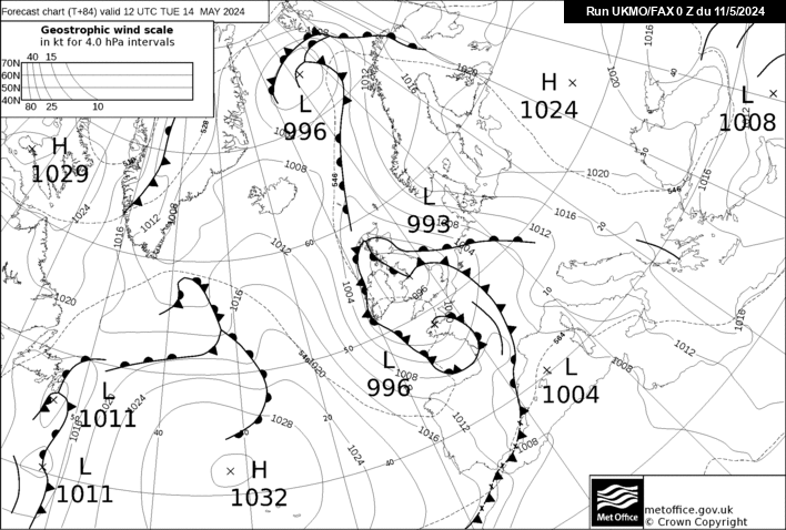
http://www.meteociel.fr/ukmo/fax/fax84s.gif
http://www.meteociel.fr/ukmo/fax/fax96s.gif
http://www.meteociel.fr/ukmo/fax/fax120s.gif
good luck to the pro forecasters
http://www.wetterzentrale.de/wz/pics/Recm721.gif
http://www.wetterzentrale.de/wz/pics/Rgem721.gif
http://www.wetterzentrale.de/wz/pics/Rgem721.gif
http://www.wetterzentrale.de/wz/pics/Rngp721.gif
jet stream charts still looking poor at present
lets see what tomorrow brings
-
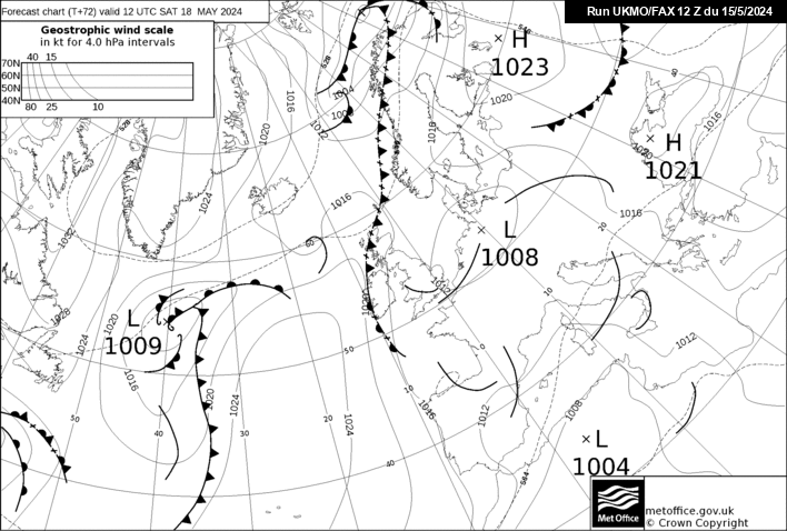
http://www.meteociel.fr/ukmo/fax/fax72s.gif
updated fax chart puts high pressure closer
to the east of the uk
this should strenghten the block more
fax charts later may be interesting
back later
-
i think fi starts 24th going by these
gfs run certainly looks too mild
-
http://www.metoffice.gov.uk/weather/uk/uk_forecast_weather.html
interesting outlook from met office for south east
http://www.null/two/ensembles/
http://www.meteociel.fr/ukmo/fax/fax96s.gif
http://www.meteociel.fr/ukmo/fax/fax120s.gif
from 96hr to 120hr look at the atlantic difference
for the weekend i think we will probably end up
seeing what the temperature is on saturday and
then checking the radar to see who gets what
i would say that we need to see the jet stream change
its course as on the gfs it does not look in a good
position for cold weather.I am not however saying that it
is right as i do not trust any chart at present.
try again tomorrow night :wacko:
-
http://www.null/two/ensembles/
updated ensembles
if you think our weather is hard to work out
scroll down to berlin and try to work that one out
-
http://www.meteociel.fr/ukmo/fax/fax96s.gif
http://www.meteociel.fr/ukmo/fax/fax120s.gif
i just watched the late bbc forecast and the
forecaster said potentially heavy snow for
scotland and the north east on saturday
being caused by low from the atlantic
bumping into cold air from the east
he said easterly winds would undercut the
atlantic low coming in but snow potential and location
would change over the next day or so
putting this into english he is saying they
are not sure yet exactly what happens at the weekend
the block to our east seems to be holding strong
but i would like to see it 200-300 miles further west
nice bom charts yamkin
i will try and make sense of the fax charts again tomorrow night
-
http://www.null/two/ensembles/
gfs is one of the warmer runs still
http://www.meteociel.fr/cartes_obs/gens_display.php?ext=1&lat=51.61943319838057&lon=0
gefs london look slightly cooler
will update later
-
http://www.meteociel.fr/ukmo/fax/fax96s.gif
last nights fax chart
http://www.meteociel.fr/ukmo/fax/fax84s.gif
todays updated fax chart
these are starting to show a weaker atlantic
more twists and turns to come again i feel
these links will change this afternoon
-
http://www.null/two/ensembles/
ensembles for what they are worth
are starting to show scatter again
21st-22nd has biggest scatter
lets see what tomorrow holds
i will be on tomorrow night with the fax updates
-
Hey JP, yet another fantastic Fax Chart summary. You do know that we ALL now expect Fax Chart summaries from the expert 'John Pike' from now on
I firmly believe that the MetO Boff's using their human interface truly have in their sights a much colder period by the end of is week. They must see the Atlantic over cooking some of the model outputs
-
hello yamkin
what do you make of the new fax charts
do you think i may be on the right lines here
john
-
Yeah cmon jp we need a lift
http://www.meteociel.fr/ukmo/fax/fax120.gif
updated fax chart for 120
sorry for the pic size
if the block continues to hold and we get
an easterly wind we could see some snow on
saturday or sunday with the low undercutting .
this is what i think the forecasters on bbc
are seeing at present but this could
still change by tomorrow
i still think the main charts could flip over
to cold again very soon
-
http://www.netweather.tv/index.cgi?action=charts;type=fax;sess=
i wonder if the bbc think the block to our north east
will be stronger than the charts are showing
just saw the 10.30 forecast and they said
much colder weather for the weekend which could
be quite interesting
the fax charts seem to show the low
to our west stalling
i still think the charts could flip again within the next couple
of days
glad i do not have to make any forecasts as i admit
i still havent got a clue whats going to happen
-
http://www.null/two/ensembles/
gfs ensembles show a much colder outlook
ecm ensembles show much warmer ensembles
lets see what monday brings
-
http://www.netweather.tv/index.cgi?action=charts;type=fax;sess=
tomorrow nights 120 fax chart could be interesting
if our block holds and moves further West it should show us
under a fairly strong north easterly flow
this is why i am waiting until tomorrow night to try
and work out the charts
-
http://www.wetterzentrale.de/pics/Rtavn18017.png
http://www.wetterzentrale.de/pics/Rtavn18010.png
fi but would be cold
snowbob remember the dates i told you
i still stick with them
will update fax later
http://www.weathercharts.org/wetterzentraleGFSforecast.htm
flick through these it looks like the atlantic
isnt getting through our block.
winters over ?
-
http://www.null/two/ensembles/
some colder runs showing here on the 12z
moscow looks freezing
still waiting until monday to try
and make any sense of the models
-
http://www.meteociel.fr/ukmo/fax/fax96s.gif
http://www.meteociel.fr/ukmo/fax/fax120s.gif
massive change from last night low heads towards us now
instead of going south giving westerly winds but cold
with 528 dam over us
http://www.wetterzentrale.de/wz/pics/Rjma1201.gif
http://www.wetterzentrale.de/wz/pics/Recm1201.gif
http://www.wetterzentrale.de/wz/pics/Rngp1201.gif
http://www.wetterzentrale.de/wz/pics/Rgem1201.gif
http://www.wetterzentrale.de/wz/pics/Rukm1201.gif
all these charts are at 120 and trying to predict next week is
still a nightmare i cannot remember a time viewing charts
and trying to predict within a few days has been so hard
http://www.wetterzentrale.de/pics/MT8_London_ens.png
big scatter 18th and 23rd
who wants to bet these are totally different on saturday
then sunday etc
i will give the boards a break for the weekend as i
like my sanity
-
http://www.null/two/ensembles/
if anyone can make sense of these their a better
person than me
i will comment later when i see the updated 120
fax chart
the gfs run looks out of kilter with all the other ensembles
the charts do look bad at present but they are only charts
so lets wait and see what later brings
glad i do not have to predict weather for a
living as i would not have a clue what to say about next week
-
http://www.meteociel.fr/modeles/ecmwf.php?ech=216&mode=0&map=1&archive=0
good night all
let the rollercoaster begin again tomorrow
-
http://www.wetterzentrale.de/pics/Rtavn1201.png
gfs
to this
http://www.meteociel.fr/ukmo/fax/fax96s.gif
fax chart at 96
http://www.meteociel.fr/ukmo/fax/fax120s.gif
fax chart at 120
for whatever reason it seems there is no update yet
on the 120 fax and i feel that will give a clearer picture
for what its worth i still think the gfs is overcooking the
atlantic and will not let the low go south
if gfs is right all respect to it as virtually all the other
main players are showing much colder solutions
i will update later if the fax updates
i will guess the gfs will show colder runs either 00 or 06 runs friday
http://www.netweather.tv/index.cgi?action=charts;type=fax;sess=
click on 120
there goes the low south
much better
-
the charts have gone mad tonight
lets hope gfs starts to come on board
i think if good charts are showing we should ramp
as this is only for fun and thats what makes the
forum what it is
long way out but wow
i will update later
http://www.meteociel.fr/modeles/ecmwf.php?ech=216&mode=1&map=0&archive=0
channel low
i reckon yamkin might comment a little tonight
-
http://www.wetterzentrale.de/pics/Recm1201.gif
could anyone tell me why this chart only 5
days away would not be good for the south east


London & South East England - The Yamkin Ramper Thread
in Spring Weather Discussion
Posted · Edited by john pike
http://www.meteociel.fr/cartes_obs/gens_display.php?x=306&y=141&run=18&ville=Londres&runpara=0&type=0&ext=1
these look different
the gfs model is not a cold outlier
winter is far from over
(i think)