


john pike
-
Posts
10,848 -
Joined
-
Last visited
-
Days Won
30
Content Type
Forums
Blogs
Gallery
Events
Learn About Weather and Meteorology
Community guides
Posts posted by john pike
-
-
http://www.wetterzentrale.de/pics/MT8_London_ens.png
wet weekend cold and dry to the 3rd
then models seem to disagree with outcome
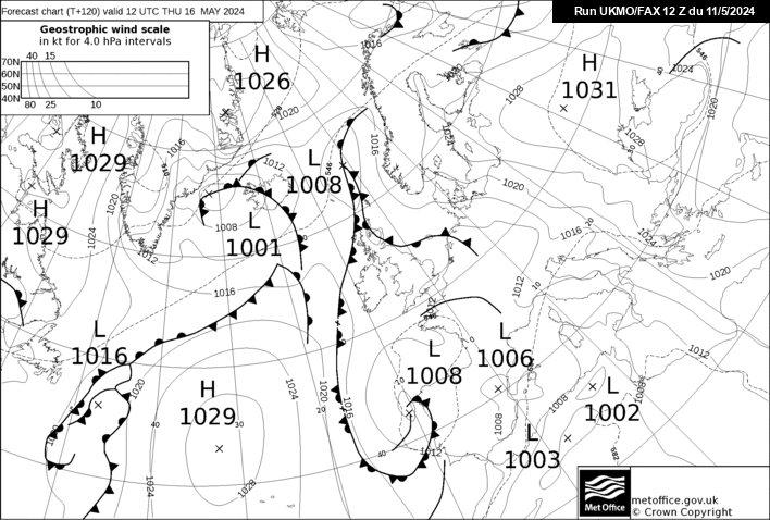
http://www.meteociel.fr/ukmo/fax/fax120s.gif
120 fax chart shows high pressure more to the west
with colder 528 dam air heading towards us
tomorrow nights fax may shed some light as to whether
we will be under high pressure for a while or it decides
to move upwards and away from us.
fax charts are worth following as it stops me taking
fi to seriously.Although i still look at them
and post the good ones.

note the 510 dam air to our east.
http://www.wetterzentrale.de/pics/Rtavn18017.png
just to show that it will not be warm.
back again tomorrow night
http://www.meteociel.fr/modeles/gfse_cartes.php?mode=5&ech=6
http://www.meteociel.fr/modeles/gfse_cartes.php?mode=5&ech=204
a final point is the jet stream seems to be all over the place
at the moment.I think we may start to see more confusion in the
charts later.
a interesting chart is the 3rd to 4th which shows the
jet blasting over us fron the North East which may be worth watching
-
http://www.meteociel.fr/modeles/gefs_cartes.php?code=10&ech=84&mode=1&runpara=0
http://www.meteociel.fr/modeles/gefs_cartes.php?code=10&ech=84&mode=2&runpara=0
http://www.wetterzentrale.de/wz/pics/Rgem841.gif
http://www.wetterzentrale.de/wz/pics/Rgem841.gif
http://www.wetterzentrale.de/wz/pics/brack3.gif
different outcomes at 84
main models seem to show high pressure in charge but
outlook looks colder but dry for now <_<
not including saturday and sunday which looks wet and windy
i will post the ensembles to see what they say soon
-
A few JP
looking forward to hearing more hi snowy
sorry about that should have only posted the 5th
but linked to main charts.
even i got confused reading that and i posted them :wacko:
http://www.wetterzentrale.de/pics/MT8_London_ens.png
ensembles for london agree on a cool down to the 27th
as these are 850 temperatures you need to add approx 6 degees
in temperature to get what it will be on the ground
the red line is the average temp for the time of year
when you get to the 1st of march you can see a bit of a
scatter.this normally means the ensembles are not in agreement
so we will have to wait probably until tomorrow to see whether
they agree.
the bottom is the precipitation spikes
the problem is they are showing very dry which could
mean high pressure is in control although these will probably
change in the morning
http://www.meteociel.fr/ukmo/fax/fax120s.gif
this shows high pressure in control so we need to
see where it goes to predict for 3rd onwards
http://www.wetterzentrale.de/pics/Rtavn18017.png
just as a rough temperature guide
i expect the charts to show cold again tomorrow
i cannot post too much in links as i only have dial up for now
should be back properly tomorrow night
-
Hi John, could you actually post explanations to all the charts you post? There are a few of us on here that the charts alone mean nothing....
hi snowraven
little busy doing something else at present
i will post later with the ensembles and fax charts
and give more info with them
-
http://www.meteociel.fr/modeles/gefs_cartes.php?code=0&ech=204&mode=1&runpara=0
http://www.meteociel.fr/modeles/gefs_cartes.php?code=0&ech=204&mode=2&runpara=0
http://www.meteociel.fr/modeles/gefs_cartes.php?code=0&ech=204&mode=4&runpara=0
http://www.meteociel.fr/cartes_obs/gens_panel.php?modele=0&mode=0&ech=204
http://www.meteociel.fr/modeles/gfse_cartes.php?ech=204&code=0&mode=1
a few charts for the 5th
subject to change
http://www.meteociel.fr/modeles/jma.php
sorry forgot this but not quite up to the 5th
-
sorry could not help myself
http://www.weathercharts.org/wetterzentraleGFSforecast.htm
nice
http://www.wetterzentrale.de/pics/Rtavn1922.png
http://www.wetterzentrale.de/pics/Rtavn1922.png
http://www.wetterzentrale.de/pics/MT8_London_ens.png
be back later for the 18z
thats for snowydayz
-
http://www.coaps.fsu.edu/~maue/extreme/gfs/current/raw_temp_c.html#picture
hello bob
did you get the im i sent you
-
colder ensembles with some touching -10 which was not showing last night
lowest last night was -5 so definately an improvement
be nice if these were showing more precipitation spikes
although plenty of time for that to change
-
http://www.meteociel.fr/modeles/ukmo2.php?carte=2000&ech=0
going by the fax charts if you run over the green
dots you can see how these are trending
i will hazard a guess they will be showing a north easterly
flow by tuesday or wednesday next week
-
http://www.meteociel.fr/modeles/gfse_cartes.php?&ech=186&mode=0
180-192 looks interesting
http://www.meteociel.fr/modeles/gfse_cartes.php?mode=1&ech=6
http://www.meteociel.fr/modeles/gfse_cartes.php?ech=204&code=0&mode=0
http://www.meteociel.fr/modeles/gefs_cartes.php?code=0&ech=192&runpara=0&mode=1
fi but cold run showing
-
Would you consider re opening them again if by some miracle we do get a nice end to winter during March?
hi jayces i second that
-
http://www.wetterzentrale.de/pics/Rtavn2402.png
http://www.wetterzentrale.de/pics/Rtavn24017.png
http://www.wetterzentrale.de/pics/Rtavn2404.png
http://91.121.84.31/modeles/gfs/run/gfsnh-0-240.png?12
http://www.wetterzentrale.de/pics/MT8_London_ens.png
long way out but someone had to do it
http://www.meteociel.fr/modeles/gefs_cartes.php?code=0&ech=216&mode=1&runpara=0
-
http://www.meteociel.fr/modeles/gfse_cartes.php?ech=6&code=0&mode=1
http://www.meteociel.fr/modeles/gfse_cartes.php?ech=204&code=0&mode=1
http://www.meteociel.fr/ukmo/fax/fax120s.gif
http://www.wetterzentrale.de/pics/Rukm1201.gif
http://www.meteociel.fr/modeles/bome_cartes.php?&ech=120&mode=0&carte=0
http://www.wetterzentrale.de/wz/pics/Recm1201.gif
http://www.wetterzentrale.de/wz/pics/Rjma1201.gif
http://www.wetterzentrale.de/pics/Rtavn2282.png
http://www.wetterzentrale.de/pics/Rtavn2642.png
for viewing only
surprisingly most of the models show high pressure builing to our west which
should keep out the atlantic.should be cold and dry and then going into march things
could start to get interesting (i did say could)
lets keep our fingers crossed the models do not do what they kept doing in january
http://www.meteociel.fr/modeles/gefs.php
shows a fair drop in temperature from 26th
quite a few cold members showing from 3rd onwards
at least the models are not showing a roaring atlantic
coming in and at least the potential for s..w is a possibility :lol:
http://www.wetterzentrale.de/pics/MT8_London_ens.png
much colder options being picked up on here
these do change but maybe a trend being picked up
what do you think of these yamkin?
-
-
:lol:
gfs looks one of the colder options
long way to go yet so worth keeping our eyes on
-
http://www.wetterzentrale.de/pics/MT8_London_ens.png
gfs is not an outlier :blink:
-
hello yamkin
thought everyone had given up
http://www.meteociel.fr/ukmo/fax/fax120s.gif
notice the 528 air coming in on the westerly
will be here sunday and will be cold :lol:
http://www.meteociel.fr/cartes_obs/gens_display.php?ext=1&x=318&y=150 :blink:
-
http://www.meteociel.fr/modeles/gfse_cartes.php?mode=2&ech=204
http://www.meteociel.fr/modeles/gfse_cartes.php?mode=0&ech=204
http://www.meteociel.fr/modeles/gfse_cartes.php?ech=204&code=0&mode=1
http://www.weathercharts.org/wetterzentraleGFSforecast.htm
fi but cold and plenty of snow in these charts
where is everyone ?
-
-
http://www.wetterzentrale.de/pics/Rtavn3002.png
long way out but worth seeing
http://www.wetterzentrale.de/pics/MT8_London_ens.png
quite a few members showing colder from 27th onwards
http://www.meteociel.fr/modeles/ecmwf.php
if that went past 240 it would probably show a strong north westerly
the northerly cold air flow
at least it gives us something to watch
-
http://www.wetterzentrale.de/pics/MT8_London_ens.png
still showing a cool down from 27th onwards
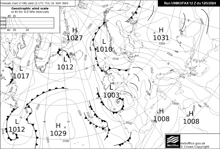
http://www.meteociel.fr/ukmo/fax/fax96s.gif
http://www.meteociel.fr/ukmo/fax/fax120s.gif
a couple of more days and the fax charts will show
the 27th to see where this cold option is coming from
assuming it is still there
http://www.meteociel.fr/modeles/gefs_cartes.php
http://www.meteociel.fr/modeles/ecmwf.php?ech=72&mode=0&map=0&type=0&archive=0
going by the charts i cannot see the atlantic being in control
for very long
-
http://www.wetterzentrale.de/pics/MT8_London_ens.png
gfs
both show temperatures below average from the 27th
more runs needed though
-
-
hi bob
the ensembles over the last few days have
shown nearly all members showing above average
temperatures
now tonight the ensembles on the 18z show at
least 8 members below average
these are a huge flip
tomorrows charts are going to be very interesting
will make the board come alive or make us want
to call gfs a few friendly names
i cannot say i was confident on the fax charts
so i will wait until tomorrow to comment on them
new trend or pub run
we will see tomorrow

 looking forward to hearing more


London & South East England - The Yamkin Ramper Thread
in Spring Weather Discussion
Posted · Edited by john pike
http://www.meteociel.fr/cartes_obs/gens_display.php?x=&y=&run=18&lat=51.1336032388664&lon=0&runpara=0&type=0&ext=1
might see some sleet-light snow monday @-7 uppers
charts still look dry and cool otherwise
http://www.wetterzentrale.de/pics/Rtavn1802.png
http://www.wetterzentrale.de/pics/Rtavn2042.png
http://www.wetterzentrale.de/pics/Rtavn18017.png
it would not take much for us to get into a much colder outlook
fi so still changeable
snowy i will give a rough forecast fot the 5th in 2 days
when the fax chart shows saturday
http://www.wetterzentrale.de/pics/MT8_London_ens.png