


john pike
-
Posts
10,848 -
Joined
-
Last visited
-
Days Won
30
Content Type
Forums
Blogs
Gallery
Events
Learn About Weather and Meteorology
Community guides
Posts posted by john pike
-
-
http://91.121.84.31/modeles/bom/run/bom-0-240.png
long way out but to lighten the mood :smiliz19:
-
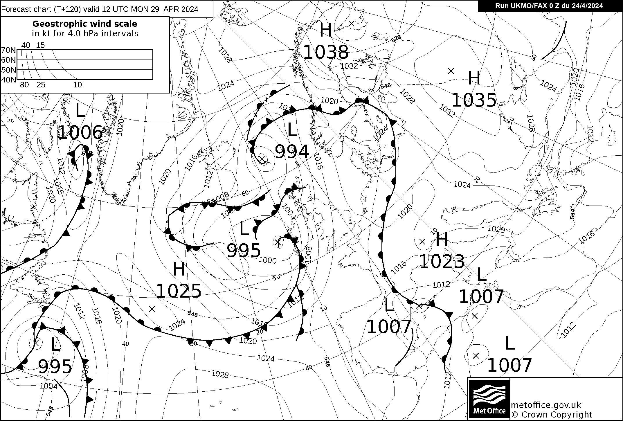
http://www.meteociel.fr/ukmo/fax/fax120.gif
if you look to the west we have the 528 dam line
coming towards the uk on the sunday fax chart
http://www.netweather.tv/index.cgi?action=charts;type=seatemps;sess=
sea temperatures look below average
be interesting to see what the fax charts
show on wednesday and thursday night
http://www.netweather.tv/index.cgi?action=charts;type=ens;sess=
ensembles still have a big scatter from 18th so still
no real answers there yet

i still think people are writing off winter too quick
-
http://www.netweather.tv/index.cgi?action=charts;type=ens;sess=
i think uncertain comes to mind here
a change looks like happening from 17th-18th
to cooler weather but more runs needed to get
a clearer picture
http://www.meteociel.fr/ukmo/fax/
going by the fax charts it certainly looks wet and windy
up to saturday
in about 2 days time we should get a better idea of the
outlook as the fax charts will show the 17th by then
-
http://www.wetterzentrale.de/pics/Rtavn2762.png
http://www.netweather.tv/gfsimages2/gfs.20110109/18/288/prectypeuktopo.png
just for fun :smiliz19:
or maybe a trend ???
ensembles could be interesting tonight
-
http://www.wetterzentrale.de/pics/MT8_London_ens.png
still showing a cool down from the 17th
i will have the kontroll please :smiliz19:
-
-
http://www.netweather.tv/index.cgi?action=charts;type=ens;sess=
more colder members showing from 16th onwards
long way out but worth keeping an eye on
-
-
http://www.netweather.tv/index.cgi?action=charts;type=ens;sess=
interesting ensemble for london
could be interesting for us 9th to 11th
there is still a big spread of temperatures after the 11th
so it still looks like a very uncertain period after that
however in fi there seems to be more colder options showing
http://www.meteociel.fr/ukmo/fax/
fax charts have improved showing 528 dam over the uk on monday
if everything moved further west these charts would be
http://www.metoffice.gov.uk/weather/uk/uk_forecast_warnings.html
met office still keeping the warnings up
i am not commenting on this because i do not have a clue
-
hello yamkin
i agree with you about exciting times ahead
the charts are still unsure where this low is going
look at the ensembles
http://www.netweather.tv/index.cgi?action=charts;type=ens;sess=
very rare we see confusion so close
look at the blue line( Control run)
that would make gfs look mild
i think friday could cause a few surprises
and we will not know until right at the last minute
a question for you yamkin
do you remember before the last cold spell the models
had a load of problems with a low coming in and got it wrong
do you not think this seems similar
john
-
http://91.121.84.31/modeles/gfs/run/gfs-1-348.png?18
long way off but could not help myself
fi showing a classic easterly
http://www.meteociel.fr/ukmo/fax/fax120.gif
528 dam line definately showing further south
on sundays fax chart
could be some twists and turns in the models yet
-
http://www.netweather.tv/index.cgi?action=charts;type=ens;sess=
i think i will wait for tuesdays charts to come out
have a look at London ensembles
i think something is brewing as the charts at present
seem to have serious disagreement from the 7th
this could go either way but knowing this winter
anything could happen
-
-
if you look at the fax charts http://www.metbrief.com/EGRR.html
they show an easterly starting on thursday which looks dry
on friday the winds look north westerly but still cold with wintery showers
look to the noth east where a low has developed
saturday shows an easterly again with showers nearby and the air out to
the east looks cold with the 510 dam line getting fairly close
friday night could be interesting if the low showing friday morning
heads towards the south east.
i have been following the fax charts and the seem to be fairly
consistant lately.be interesting to see where the 510 dam line
ends up tomorrow when sundays chart will be showing
i do not think the cold weather has given up yet
john
fax charts still consistant with last night but still uncertain how
close this low will be to us over friday afternoon-evening.
the saturday and sunday charts look fairly cold with easterly winds
still showing.The charts do not show much precipitation but convention
could build up due to the slightly warmer sun.
overnight temperatures look very cold friday night onwards.
i will do another update on the fax charts tomorrow and hopefully they will
stay consistant.
john
-
if you look at the fax charts http://www.metbrief.com/EGRR.html
they show an easterly starting on thursday which looks dry
on friday the winds look north westerly but still cold with wintery showers
look to the noth east where a low has developed
saturday shows an easterly again with showers nearby and the air out to
the east looks cold with the 510 dam line getting fairly close
friday night could be interesting if the low showing friday morning
heads towards the south east.
i have been following the fax charts and the seem to be fairly
consistant lately.be interesting to see where the 510 dam line
ends up tomorrow when sundays chart will be showing
i do not think the cold weather has given up yet
john
-
the london ensembles look in fair agreement
for a cool down from 3rd March onwards
http://www.netweather.tv/index.cgi?action=charts;type=ens;sess=
t48 fax chart http://www.netweather.tv/index.cgi?action=charts;type=ukmomod;sess=
shows the centre of the low pressure closer to the south east uk than last
nights fax so a little more concerning.
think we will have to nowcast this storm and although i enjoy stormy
conditions i think i would prefer to see this storm move away from us.
-
if you look at the fax charts
t60 http://www.wzkarten3.de/pics/brack1a.gif
low pressure heading close
t72 http://www.wzkarten3.de/pics/brack2.gif
centre of low pressure (looks like 980)
is in the Channel between south east uk and France.
t96 http://www.wzkarten3.de/pics/brack2.gif
shows low pressure moved away very quick
although see the 528 dam line across the uk
t120 http://www.wzkarten3.de/pics/brack2.gif
shows the 528 dam line moving towards the Midlands
this also shows another low pressure system coming
in from the South West which if it goes below the uk
could turn the winds Easterly from thursday onwards next week
although whether this would be dry due to high pressure being close
to the uk is too far out to say.
the storm for Sunday according to these charts would be gusty for South
coasts and the South East at the moment but a movement of 100 miles either
way would make a huge difference and still needs watching.
watching this storm develop will be interesting as it could be a forcasters
nightmare and could end up being a now cast scenerio.
thats how i see it now and i bet it will be totally different tomorrow
john
-
hi yamkin
Another Croydon member
it looks like the forcasts are going by the fax charts
http://www.metbrief.com/EGRR.html
these show dry conditions on saturday and sunday
however look at monday as this would be a great
chart for snow over the south east.
these charts will probably look different again tomorrow
but hopefully monday will stay the same
john
-
18z looks good for a few days
from what i can see from fri 19th East areas may get some light snow
in the evening.Sunday 21st South East should see light snow showers.
Monday 22nd shows a Channel low which might give some heavier snow for
a time which should be around until Tuesday morning.
This could all change by the morning.
The only concern is that the 18z is showing the jet come to life around
the 28th although this is a long way off.
This is my first attempt at this so lets see what happens
lets hope i am not doing this later.john
-
Three heaters?
Welcome to the forum John
thanks for the welcome
enjoy your snow in kent
metoffice radar looks like showers
pushing slightly further inland so
might get some more here soon
got to go to bed as have to be up early
night all
-
my first post on here but been on site for a while now
just started snowing again and could be a bit more going by radars
if it does not peter out.
are you still on snowbob?


 lets hope i am not doing this later.

London & South East England - In Between The Cold Spells Discussion Part 30
in Spring Weather Discussion
Posted
http://www.wetterzentrale.de/pics/senspanel2401.html
can you work out the 23rd from this???