


Cumulonimbus Tower
-
Posts
270 -
Joined
-
Last visited
Content Type
Forums
Blogs
Gallery
Events
Learn About Weather and Meteorology
Community guides
Posts posted by Cumulonimbus Tower
-
-
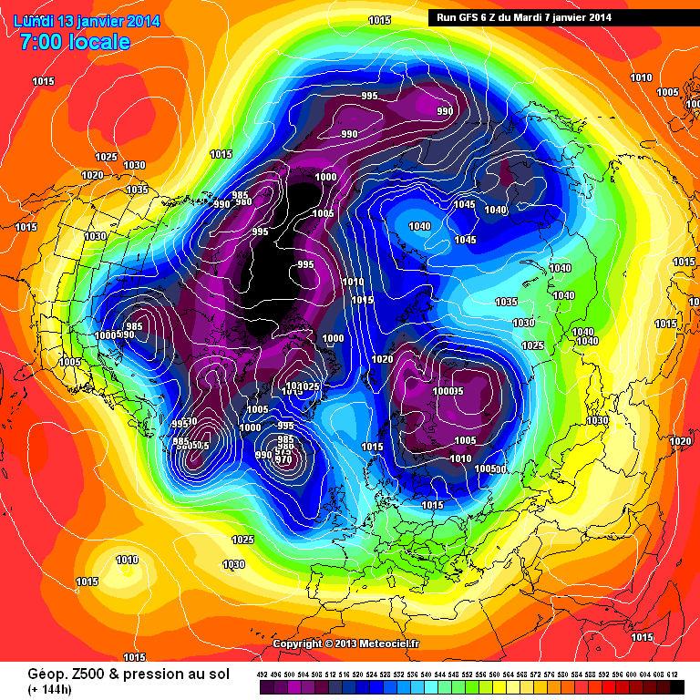
http://modeles.meteociel.fr/modeles/gfs/runs/2014010706/gfsnh-0-144.png?6
finally after days of GFS misery the model puts 2+2 & lands @ 4 instead of 7.
Wedge of high pressure into the right location.
S
The question is, can we get an undercut out of this GFS? Don't know too much about jet profiles but it seems to be heading deep South and East around 180h
-
GFS 6z seems to have ther WAA aligned slightly more favourably for building heights to the NE. Wonder if this might be a slightly better run for coldies than the 00z.....
In fact it's looking remarkably like the GEM at 144 and not too dissimilar to the ECM.....

-
 1
1
-
-
Always seems to be out earlier on there
SK
Interesting to see the GEM now getting it's heights from an atlantic ridge moving out of the western Atlantic from 120h. Very possibly what the UKMO would have been onto if it went out further.....
-
Why would he be ecstatic, just wondering? to see heights shunted east, the Atlantic sweeping through and a return to general zonality.. I'd have thought that would make him rather sad.
I would imagine it might be because the GFS has changed in it's position to a more meridional flow relative to previous output, which Steve has been predicting through many of his nuanced analysis of model output over the last several days.
-
3
-
-
UKMO not very amplified and rather zonal unfortunately
Hmmm. it doesn't encourage much optomism this eve does it? All i can clutch out of that one is perhaps there are high pressure reinforcememnts heading across the atlantic from Bermuda.
-
Big steps.
Jet streak heading due north to the west of Ireland on the 12z helping to inflate the HP to the North East of the BI, as opposed to curving East over the top of Scotland and flattening out the pattern previously. This could well be the GFS climb down that has been so much anticipated!
...and is that hints of a trigger Low at 156 heading into Europe? Maybe too much to ask for in one run
-
4
-
-
Ought to change its name to CFG - Chocolate Fire Guard!
Or Chocolat Fire Surround
-
1
-
-
GFS 12z much more progressive with cutting off the flow to the ridging to the north of the UK. At least 36 hours earlier than the 0z, and that restores the surface flow over the top. T138:
gfs-0-138 (1).png Very flat.See if a second shot appears after T200.
Interestingly has -5 850hPa air flirting with the north west of the UK by next fri/sat though.....
-
The 06 gfs was a step away from the 00 gfs zonal express and the 12 gfs looks to be a further step away from an atlantic driven 06h gfs. It will be interesting to see where we are left after the other output this eve but i suspect it won't be as zonal and mild as we were this morning....
-
06 gfs looks to be running out of puff as it crosses the atlantic compared to the 00z. Whilst it's obviously a depressing morning for coldies, I still don't think this has run it's full course yet. Not if the GFS is still chopping and changing its mind at such short timescales and some of the lesser models (And bigger models to a lesser degree) still fancy a chance. Watch this space
I strongly concur with what TEITS says about fickle Easterlies too. Over the last eight years or so there seems to be a recurring theme, of them vanishing overnight to re-appear a couple of runs later.
-
3
-
-
Could i just ask, has anyone noticed that on Meteociel, the UKMO charts for 12 today seem to be different from those on Wetter? I suspectt they havn't updated but the time signature looks ok. Just confusing the heck out of me after 1.5 cans of stella
-
Since getting over the pleasure of seeing the ECM this evening, I have been looking at it's output side by side with the other 3 models which imo support the evolution tionight. The UKMO seems even better to my untrained eye (Agree Cooling Climate, just seen your post) with, as previously mentioned the JMA and GEM coming on board. I hope (And now slightly expect) that the too progressive GFS will have to come onboard over the nexy 12 to 24 hours. Roll on the 18z 's and more particulally the UKMO 18. Good call Steve M, Nick S & Et al. Could we be about to see winter in the isles for the first time?
-
4
-
-
Can i just ask if any flash warnings of severe weather have been issued regarding the precip moving in over Mersyside atm? My missis is at the Trafford centre and i was going to advise her to leave it a couple of hours before travelling along the M62. thanks
-
A new model for people to use now is the UKMO euro 4 which is now available here http://www.weatheronline.co.uk/cgi-bin/expertcharts?LANG=en&MENU=0000000000&CONT=euro&MODELL=euro4&MODELLTYP=1&VAR=prec&HH=3&BASE=-&WMO=&ZOOM=0
Well it will be interesting to compare the track of the minor feature tomorrow with the predicted NAE and Euro4 tracks as they have a signifigant diference between them. Less shower activity for the coasts shown on Euro4 too i think....
-
My head says the UKMO is a rogue operational run that will bite the dust by tomorrow, my heart says its nearing Xmas and that slowing of the zonal winds in the strat near the pole will deliver an emergency pressure rise up there to deflect the jet further south and that the UKMO still believes in Santa!
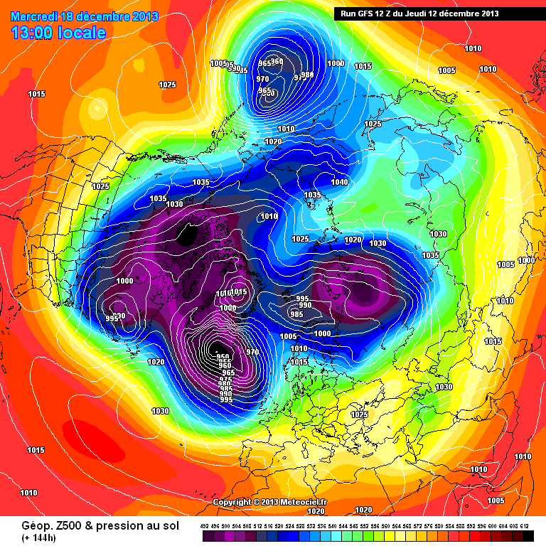
Wondering if what the UKMO hints at today is what Steve M was alluding too yesterday when he posted this http://modeles.meteociel.fr/modeles/gfs/runs/2013121212/gfsnh-0-144.png?12
-
2
-
-
http://modeles.meteociel.fr/modeles/gfs/runs/2013121212/gfsnh-0-144.png?12
HUM.... has the fat lady got her throat sweet stuck! ?
S
Are you still looking towards the illusive rise in heights over Scandinavia there Steve?
-
Yes it's always considered at Ops Centre (despite some less favourable performance at times) but it's not got any meaningful support as it stands right now re the Scandinavian high evolution (12z EC is obviously yet to be seen) and isn't the favoured solution. The longer-range ensembles and flow diagnostics, aside from hints from last EC32 (updated output due anyway on Fri) don't generally paint any compellingly colder signal through to Christmas but we've a long way to go on all that, so it's not worth hanging-out all the detail on the regime clusters etc (we focus on stuff sub-T+240 generally anyway).
So is the GEM not particulaly facvoured because it is the wrong set up or because its evolution is just too fast? I thought i read that high pressure to the North/East was a favoured solution by the met yesterday (EC 32 solution too) although this was around day 15? Sorry if i picked the wrong end of the stick up somehow.
-
2
-
-
The 12z ECM has shifted the idea of a Scandy/Russian high a bit further East than some earlier modelling. I wouldn't say that the idea is dead in the water as this kind of feature is notoriously difficult to model but again, it isn't looking like a firm favourite either. I'm glad there is some support for the idea from a couple of the smaller models this evening otherwise i think i would have given up on the idea personally. Worth keeping an eye on IMHO but lets avoid getting hung up on a need for immediate freezing conditions. Lets also avoid writing off winter for the moment as well can we
I do find what the GFS is showing this evening very boring indeed, however, there is a long way to go and quite often things happen from seemingly nowhere at a fairly quick rate of knots. -
METO 144 looking full of Northern Promise too. Well maybe not exactly Northern but i like the look of it non the less....
-
The lack of posts for the 18z GFS reflects how uninteresting things are atm, however at 141hrs there may be sign of relief as the low coming out of America,is perfectly tilted to shoot those heights towards Greenland and is a great upgrade compared to the 12z, will this thread shoot back to life as the GFS rolls on?
Sorry to be off topic but i think the lack of posts may be to do with the masses of snow piing up outside this evening rather than the search into deepest FI-land for more.....
UKMO looks like it may be onto something at 144 btw. It's been quite good of late hasn't it?
Ned
-
Looking like theres a patch of ppn growing around Manchester as the wrap around from the low pressure tries to push north East. I'll be watching this as i think it's my only hope of any more snow tonight
you could have greeted my 1000th post with a little bit more enthusiasm
-
Whilst the development of a low pressure system over the Irish Sea, holding up the Eastwards advancement of the front tomorrow does undoubtedly mean some areas won't see as much of the white stuff as previously hoped, looking at the NAE in more detail I do wonder if the development of this system will actually mean that the precipitation lasts longer across some areas, particularly the North East, where as it was going to die out fairly readily previously, the Easterly wind looks to pick up and I can see tomorrow night turning into quite a raw, blowy and snowy picture across large swathes of the BI. And lets be fair, it is possible that wider areas of the Irish Republic will get a bit of snow too, which seems only fair!
-
The thing that strikes me most about the ECm 192h chart. Thats the one for over a week away
is that the atlantis still looks like it has just run out of steam and can offer no meaningful attack on the cold block established over NW Europe.... -
Can anyone more knowledgable please clarify why we are looking at a probable undercut in this scenario when we have a relatively weak block (1020 mb or so) coupled with a ferocious amount of energy in the Atlantic (even allowing for the GFS being OTT as it surely is in that regard)?
Is it because with low pressure over the continent, the energy looks likely to take the path of least resistance, and that is to be found to the south?
Compare this to December. Why does the Atlantic not just blast the little Scandinavia high aside, as it did then? Yes I am a little sceptical about the models, but I guess if even the GFS is starting to show that at fairly short range....
I'm no expert but my understanding is that the jet over the Atlantic looses all its energy because it is not supported at higher altitude because of the Stratospheric warmings we have/are recently experiencing. Whilst it looks the same, the energy 'attacking' us isn't the same so the troughs disrupt instead of barreling over us... However by posting on here im sure I'm leaving this open for a better interpretation..... .


Model Output Discussion 1st January 2014-06z onwards.
in Forecast Model Discussion
Posted
It gets silly once it goes in to the low res part of the run but i've seen enough to be happier again