


moffatross
-
Posts
350 -
Joined
-
Last visited
-
Days Won
1
Content Type
Forums
Blogs
Gallery
Events
Learn About Weather and Meteorology
Community guides
Posts posted by moffatross
-
-
Beautiful here at Moffat too, Hawesy, it's almost spring-like with the sun having genuine warmth without the strong wind. Lots of snowdrops poking through, but no evidence of daffodils or crocuses yet.
Reading through the MO thread ramping, I can't help thinking that there're going to be some toys thrown out of prams. There's really nothing spectacularly wintry to expect anywhere in the UK in the next week or so, and even when and where uppers get '100% snow' low enough, little in the way of convective opportunity, and not much evidence of anything other than light frontal ppn to be expected.
-
 2
2
-
-
13 hours ago, CatchMyDrift said:
No-one in the south will win a longest snow patch competition, it's going to get hairdryered away:

Watch out my northern friends, there's some severe gales coming too:
I hope quite a lot will survive at elevation. At 700-800 metres, the average height of the Southern Uplands tops, temperature will be 3-4 C in the heaviest rain and strongest winds so the tops (which like the western aspects have skinny depths already due to the wind deposition) will end up bare as bones. The deep depositions on eastern aspects sheltered from the wind a little will suffer some depth loss but will survive this thaw, and higher parts of those slopes will benefit from a refreeze soon after. Chances of long-lasting snow patches are much, much higher this year than the last couple but I agree, without new big snowfalls, they're unlikely to beat the June survival records.
-
1
-
-
- Popular Post
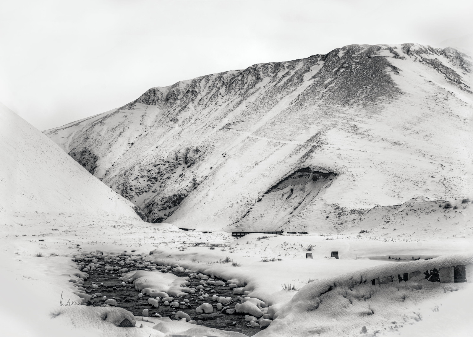
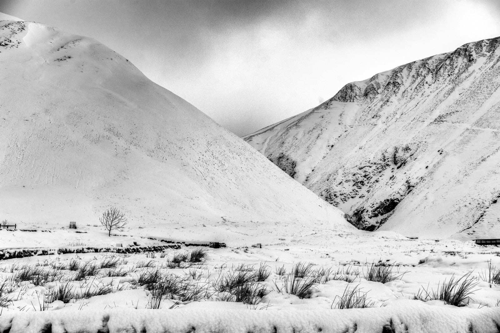
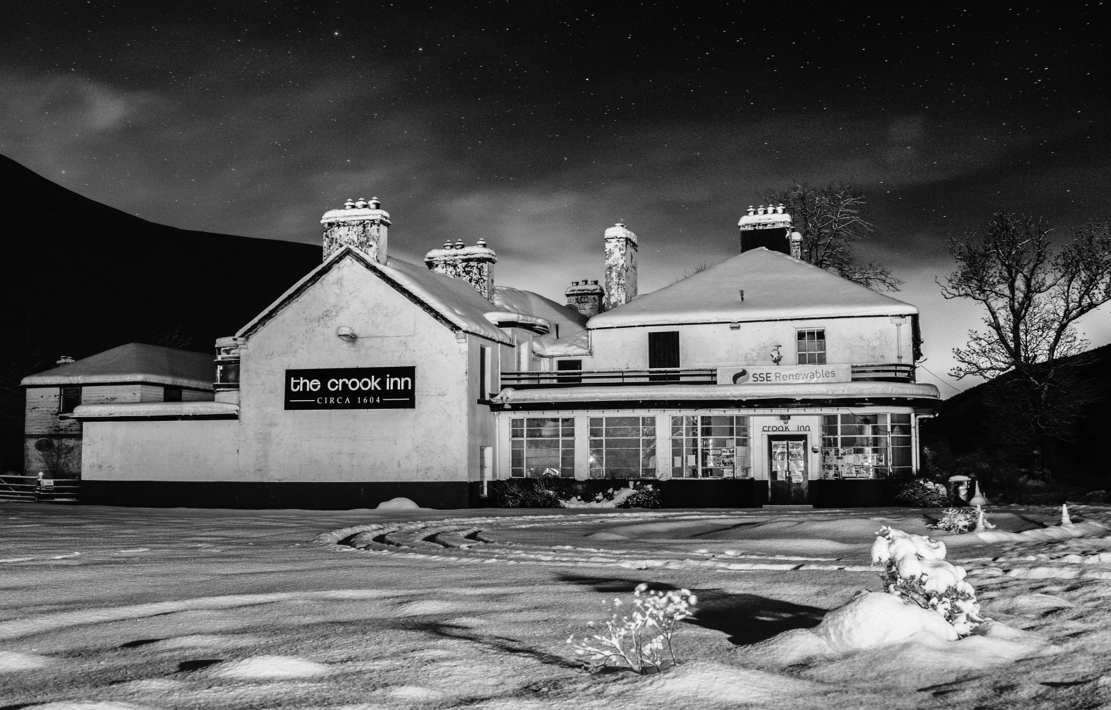
I was working in Peebles today, and took the road east out of Moffat, past St Mary's and over to Innerleithen via the Gordon Arms in the morning. On the way past the Grey Mare's Tail, I stopped for a couple of photos. On the way home tonight, I went via Stobo and Broughton and put the camera on a tripod for a long exposure of the lonely and abandoned Crook Inn at Tweedsmuir. Thought I'd give them all a b/w rendering as none of the light was particularly colourful. Anyhoo, there's a lot of snow out there
http://rossofmoffat.com/albums/midwinter-snow/
-
20
-
- Popular Post
5 minutes ago, Spindrift2017 said:The guy who installed that webcam posts on here (moffatross?) - I believe he is involved with the Lowther Hills ski club, which should get some action at the weekend. The two villages in the area (Leadhills and Wanlockhead) only have a population of a few hundred each. Was up there in December and it was difficult to park the car because all the lay-bys and parking spaces were full of snow, but there is definitely a fair bit more now than the pre-Christmas snow.
I was up in Wanlockhead this evening to do some measuring up for a job, and I called in to the Hopetoun Arms at Leadhills to say hello on my way back out. There's a lot of snow, maybe 30-40 cm level on average, and most lay-bys are unusable so if you want to park, best carry your own shovel to dig a spot. The roads are clear enough just now, but were intermittently white with fresh snow tonight and there's quite a lot of ploughings scattered about so wouldn't recommend driving them with a vehicle with low-profile tyres. Met up with a pal to had a wee headtorch ski on the hill to the north (Broad Law) of the road from Leadhills down to Elavnfoot, and lovely powder it was too
...
-
14
-
32 minutes ago, shuggee said:
I think the A701 is back open now over the Devil's Beeftubs - not very often that that gets blocked and Moffat gets cut off from the north. Two gritters in convoy went passed at around 10am here - followed by a convoy of a dozen cars and trucks.
Thanks for the Intel.
I'm working in Peebles on Friday so good to know the road through to Broughton is open.
-
23 minutes ago, 101_North said:
Warnings updated! Amber for a large part of Southern Scotland. Many members could have some serious snow depths by tomorrow morning! My area is in the yellow zone but honestly expecting hee haw this far north of the low. If it happens to be 50-100 miles further north when it arrives then game on!
Heavy snow showers all morning here. There's around 20-30 cm depth, but in between the heavy stuff, the snow has turned sleety and the depth compacts a little. I've been slowly clearing the dirt track to our place but it's about 100 metres long and every shower that comes by makes me retreat indoors. Being self-employed, not getting out, or other people crying off because of the weather/roads costs me and I'm hoping the disruption over the next couple of days from the overnight snow is minimal.
-
1
-
-
By the looks of what's out over the North Atlantic, there's loads more potential for this evening and night.
-
6
-
-
- Popular Post
Nuking it again. This is my other half's car a few minutes ago.
-
12
-
Puking down again now, but with the day warmth, it's on the cusp of marginal. I've just used the van to compact the snow on the gravel to our house (fresh winter tyres are great
) in the hope of preventing the need for shovelling later, and driven into town for the messages. While the snow here (about 50 m higher than town) is mostly dry, in Moffat itself, it's slushier and significantly less deep. Just heard that Annan on the coast is green, and snow has turned to rain in Dumfries. Elevation is all, and I may head up to Leadhills later to help out with the ski tow and get some photos at some proper height.
-
1
-
-
I mentioned yesterday that I was surprised the Met Office hadn't issued an amber warning bearing in mind the model guidance, especially from the WRF high-res, but I see they've issued it up today so better late than never. There's already 10 cm of lying snow in Moffat and the showers are piling in so I wouldn't be surprised to see 20 cm+ by the end of today.
My wee van stands out like a wasp in your ice cream
-
9
-
-
After a few failed, sleety shower attempts, the latest one has turned everything white in Moffat. The Met Office's take and timings for here have been exemplary and even a cynic like me will go to sleep happier that tomorrow's uppers will be low enough for the main event
-
Mad snow depths modelled by WRF now, and considering how much truck the Met Office give that model, I wouldn't be at all surprised to see them issue amber warnings soon.
Sorry to ramp, but when a 'serious' short term mesoscale weather model suggests it's possible that wide areas might see 30-40 cm, I just can't help myself
-
4
-
-
Loads of uncertainty for Wednesday into Thursday of course with the 12Z GFS modelling Wednesday night's storm 100-150 miles further south. Consequently, even at 'peak mild', its suggested DPs remain freezing or below for Scotland from tonight until Friday at least so reducing the chances of a slush-fest. Only one model, and one run but I'd take it !
-
2
-
-
4 hours ago, Hawesy said:
Right just for fun here are some personalised snowfall predictions - these are for accumulation by the end of Wednesday and do NOT include Wed night/Thursday's potential storm.
@aggy 5cm
@More Snow 1cm (sorry mate - can't see the showers getting that far east!)
@edo 5cm
@Stormeh 12cm
@Ravelin Trace (too far east!
)
@Blitzen 8cm
@Norrance 5cm
@Ruzzi 17cm
@snowidea 8cm
@101_North Zilch
(Just kidding....7cm)
@CatchMyDrift 6cm
@Hairy Celt 4cm
@scottish skier 8cm
@GraemeB 10cm
@moffatross 15cm
@snowy owl 3cm
@mardatha 15cm
@mistyqueen 7cm
@grifter 9cm
@Northernlights 6cm
@Northern Strath 5cm
@NorthernRab 7cm
@Benvironment 10cm
@Polar Gael 12cm
and er,
@Hawesy 1cm
Apologies if I've missed you out.....though it's probably a blessing!
Thanks for that and fingers crossed
In corroboration, here're some of the weather model take on snow depths by Wednesday night ...
WRF. This one's especially noteworthy as it's a major contributor to the Met Office's unified model ...
ECM. Inputs to Met Office's unified model too and the attached is its ensemble average from last night's run ...
GFS. It's usually bonkers but is loosely in agreement with the others just now ..
-
2
-
-
- Popular Post
- Popular Post
I'll be kkeping a keen eye on the webcam in Leadhills tomorrow afternoon, and then through Tuesday. Me and another member of this forum ;-) installed it in the Hopetoun Arms about a year ago and it's made for great weather watching .... http://www.winterhighland.info/cams/lowtherhill/
This was one of the scenes I captured early December when the Christmas lights were up ...
http://rossofmoffat.com/albums/prints/content/hopetoun-arms/
-
14
-
Awesome day again. Bizarre to think that a week ago we had a couple of inches of snow lying outside.
-
5 hours ago, 101_North said:
Absolutely Baltic! Grey, a whopping 8c and the strong easterly would skin you! 7th May........
Aye, about the same here in Moffat too. Been dressed in winter coat, woolly hat, neck snood and gloves, attempting to paint the gates. Given up now as I'm freezing cold, have purple hands, numb fingers and with paint blowing horizontally off the brush, getting to any lee-side metalwork would result in me being painted black too.
-
On 20/03/2016 at 8:51 PM, moffatross said:
The Met Office has updated its longer term forecast, dropping the suggestion of a return to high pressure and settled weather in the north by April, and replaced it with generally unsettled through early April, with the wettest and windiest weather in the north. Boo, sucks !
Four days on, the suggestion of a return to high pressure dominated weather is back in the MO longer term narrative.
The major models all show a precursor low diving south @ 144 hrs ...
UKMO @ 144 ...
ECM @ 144 ...
GFS @ 144 ...
The GFS models the WAA having pumped up a block just a few days later ...
And that block then sticks around in one place or another throughout the run ...
The ECM only delays the WAA, but I suspect the unseen (for us armchair amateurs) mean at longer range would reflect the MO's updated text ...
Meantime, while the Met Office have issued a SWW for gales in Englandshire on Saturday, the strongest winds from the weekend storm are actually modelled to occur over Scotland. The Central Belt looks like it'll see particularly lively gusts around the time of the change of clocks to BST in the wee small hours ...
-
Is that a giant fish symbol between Scotland & Iceland for the N. Atlantic fleet ...
-
1
-
-
The Met Office has updated its longer term forecast, dropping the suggestion of a return to high pressure and settled weather in the north by April, and replaced it with generally unsettled through early April, with the wettest and windiest weather in the north. Boo, sucks !
-
3 hours ago, SW Saltire said:
Was 6.5c at 7am. No idea on temp now as in back in bed but sun is annoying me.
The met office had this down as a very cloudy weekend here... Yesterday was very sunny after 1pm and today could be spectacularly good.
Reached 13.7c yesterday, hopefully over 14c today. Going to the beach later although i'll need a jacket tbh
Just come back from Dumfries, and can vouch that it felt like summer down there, warm & 100% blue sky. The wind direction has clearly changed because Moffat has about 90% cloud today.
-
1
-
-
Just now, CatchMyDrift said:
Sorry, I was being sarcastic about the BBC weather map and never explained it very well. Plus there are islands missing up the west coast...apart from that yes I can see the point about the sunshine
Haha !! I get you now. Sorry for being dumb ... I'll blame it on paint and chainsaw fumes !!
-
6 minutes ago, 101_North said:
Seeing as I've only been on here to whinge recently it's only fair to report a stunning day! Absolutely beautiful!
In for a cuppa again from working outside. I've left the doors & windows open and we've had both a butterfly and a bumble bee inside the house today.
-
4 minutes ago, CatchMyDrift said:
I couldn't work out was wrong with the map.
As for it being t-shirt weather today, it is in the house as the fire is on, it's what seems like the new normal, grey and cool outside.
Nothing wrong with the projection, it's standard. It's more where the sunny breaks were that's unusual. Don't you agree ?
Sorry you're still not seeing any of the sun though.


 )
)


.png.960cc6f4279e572d3022fdd09362288d.png)


Scotland/Alba Regional Weather Discussion - 16/01/2018 Onwards
in Regional
Posted
Yes, that's fair and realistic, unlike some of the comments in the MO thread talking of the UK being blanketed in deep snow (which of course might happen but is fairly unrealistic). I wonder sometimes whether some of the most extreme rampers aren't merely closet trolls, getting off on setting up spectacular expectations then enjoying the forum fireworks should the reality turn out to be closer to a damp squib.