


weirpig
-
Posts
10,425 -
Joined
-
Last visited
-
Days Won
2
Content Type
Forums
Blogs
Gallery
Events
Learn About Weather and Meteorology
Community guides
Posts posted by weirpig
-
-
2 minutes ago, MattStoke said:
Have you got the link for those charts, please?
https://weather.us/model-charts/euro/2017120512/europe/snow-depth-in/20171210-1200z.html
like I said midlands north especially you in the north of the region .
-
 1
1
-
-
4 minutes ago, feb1991blizzard said:
Not true, GFS has a dumping down the spine of the country, ECM has snow Birmingham Northwards and deep snow Manchester Northwards.
EDIT : do I think those ridiculous snow totals will verify, not in a million month of Sunday's, but that's what the model is showing.
Thank you thought I was going mad. Anyway pointless looking at the raw charts for precipitation. Altitude etc will come into play
-
Just now, northwestsnow said:
well its only my two peneth but i think higher parts like the pennines will get clobered on that EC120-
Yep decent for midlands north. As always with these type of events
-
4 minutes ago, I remember Atlantic 252 said:
Their, and I will be right
you could well be however you are guessing at this range you know it and everybody else knows it Any way I have more important things to do then talk nonsense to you. I have a very nasty boil to lance. Ps have you been discussing this scenario with your mentor?
-
1 minute ago, I remember Atlantic 252 said:
confident yes, all over by Sunday at low levels, not the 90's anymore, ECM will confirm it tonight
And that quote shows exactly why new comers must be pulling there hair out . Confirm tonight? When there is such a spread in the ensembles ?
-
25 minutes ago, I remember Atlantic 252 said:
for most of us then, told a few people today too, I'm that confident, 2 day cold shot, a few snow flurries likely, Fri/Sat, and milder again on Sunday
So your sure of the slider lows position Sunday? Please let the met know. Way too much knee jerk reaction. Sunday and after won't be settled till Friday
-
Nearly Time for the 12z Lets see if this chesire streamer can get going again. and also that all important Sliding Low. which historically gives us a right old dumping.
-
W COUNTRY FRI: This warning is for W Somerset/N Devon in particular, albeit snow showers will likely occur (less disruptively) across other parts of the @bbcpointswest region too
There we go guys snow could be anywhere in your region
-
 1
1
-
-
2 minutes ago, jvenge said:
For sure, the right place for it, unlike 90% of the posts in the other thread ;-)
But, sometimes solutions are better than moaning, yes? So, for me anyway, I'll add a few people to ignore each day, as there are some thoughts I'd want to read, but I don't have the time or patience to read through the manure to get to it ;-)
There does seem a lot of knee jerk reaction from one suite to the next. If people took a look at the background signals then there would be less panic spread amongst the thread. Cold with chance of snow. models will flip as they gain parity And as the old adage goes, The Weather dictates the Models not the other way around if everyone kept hold of that then everything would be fine. if maybe a little less exciting.
-
1
-
-
parts of our region in the warning zone. Still to early to predict how much. a few sites state about 3 inches here for Friday. but could quite easily be none. Troughes fronts etc could pop up anywhere though
-
Quote from Ian Fergusson granted it was at Midnight and from the 12z but the statement holds very true some may like to take head of what it says.
Fair spread by 00z Mon in latest (12z) ECMWF postage stamps, both positionally & developmentally. Much, much too early to call re outcome nationally let alone regionally.
-
7
-
1
-
-
5 minutes ago, I remember Atlantic 252 said:
looks great

It sure does Chris Fawkes also mentioning Troughing appearing bringing showers inland. That and the chesire streamer we could be looking at significant amounts
-
1
-
-
2 minutes ago, Ice Day said:
Here's one for the North Wales/North West England Massive! Just 96 hours away now.
Yes this could turn into an event acrss Wales North England and the West Midlands And across Parts of the South West The strength of the wind will really blow these showers through. Not long before it comes into High Res on the Euro 4 etc seems every run at the moment is an upgrade for these areas.
-
2
-
1
-
-
Just now, Summer Sun said:
On the left under Select parameter
https://weather.us/model-charts/euro/england/temperature/20171204-2100z.html
Bless ya thank you
-
Can someone post me a link to ecm precipiton totals please. I've misplaced it ta.
-
Looking good again for Friday. Amount of snow is up in the air. And the totals on the gfs are not to be taken seriously . With a strong wind showers or more organised bands of precipitation will push way inland we could well have a few surprises
-
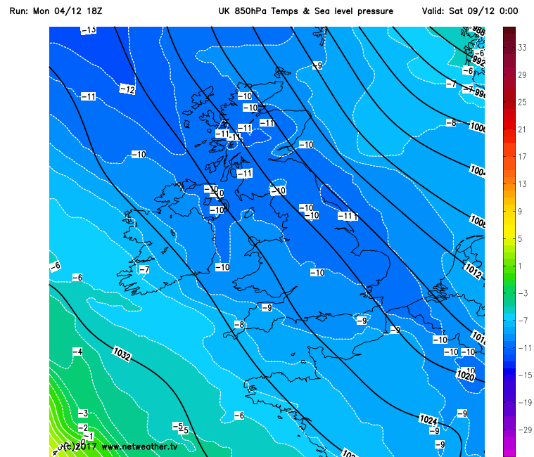
Well again Wales northwest midlands in for snow Friday Cheshire gap coming into play again . Below chart illustrates it well
-
3
-
-
Also what i find quite encouraging is that although produced this morning at 3am the metoffice are already mentioning snow showers for this region.
Becoming windy Wednesday with widespread gales and heavy rain moving eastwards later on. Rain clearing early Thursday then turning much colder from the north with blustery snow showers possible occasionally.
-
Well very good 6z for snow for the midlands. The Chesire Gap in full effect has showers barrel through on a Stiff breeze elevation as always will help with accum could be interesting come Friday
-
1
-
1
-
-
whilst everyone seems to be looking towards the slider event as the Northerly becomes more in range GFS Precipitation charts show quite a bit of snow for some parts on a stiff Northerly Chesire gap in effect also
-
8
-
-
Snow for quite a bit of the uk on the gfs12z
-
1
-
-
Anyone who is exposed to a Cheshire gap streamer could well see a bit of the white stuff come the end of the week
-
3
-
-
Could well be a snow fest for some next week if it comes to pass shovels at the ready. Apart from Norfolk
-
1
-
-
In reply to Blues post Were should we in peoples opinion post ensembles from?. I post Birmingham a because its near here and B because its the centre of the universe. i mean England shall we all have one specific area were we post them from?.
-
2
-


Model Output Discussion - cold spell to end Autumn
in Forecast Model Discussion
Posted
To honest m w b. Any precipitation charts at this distance are less than reliable