


R.P. McMurphy
-
Posts
1,833 -
Joined
-
Last visited
Content Type
Forums
Blogs
Gallery
Events
Learn About Weather and Meteorology
Community guides
Posts posted by R.P. McMurphy
-
-
Oh joy...another storm to batter the country....just what the doctor didnt order...more damaging destructive winds...more disruption to power supplies and the transport network and more flooding misery.
Just puts the tin hat on this pathetic revolting perma-autumn.
Sorry I don't find such weather "interesting" but this weather has a negative impact on people's lives and has no redeeming features to it whatsoever.
January is a write off...bin it.
Cool story, Bro'.
-
 2
2
-
-
Shoot me down, if u want. But.....Isn't wintry showers esp over high ground pretty bulk standard average for the UK towards the end of January?Admittedly it's a change from what we've experienced so far this winter but what seems to be arriving in the next week is just 'normal'.
Certainly normal for other winters, but not this one.
Besides, snow is snow !!
-
1
-
-
I prefer to use high-res modelling where possible rather than GFS Operational charts and the high res stuff only goes out to 48hrs currently, hence why I didn't go no further than 06:00.
You're right in that the GFS Op is a little more bullish in bringing some wintriness more widely across the UK, but it's not something I would put much confidence in re snowfall personally.
Let's hope future high res output upgrade the potential though.

Yes agree re High-Res - but even Metoffice going for Wintry showers on Thursday now too.
Fingers crossed.
-
1
-
-
Not really, you can't choose 6AM charts when the Front isn't even here. Looking at the actual time it's crossing:
100M.
-
2
-
-
Forget FI - We have a potential snow event on Thursday (2 DAYS AWAY!!!)
Mainly for the North & Higher ground, but might surprise a few...
Latest FAX shows the two occluded fronts, and the 528DAM...
-
5
-
-
Morning all,
Some decent charts this morning from the ECM into FI - Looking at the more reliable, some decent looking snow maps too:
Thursday could be the first snow we have seen all Winter & we should be watching these developments with a keen eye !
-
1
-
-
- Popular Post
Precipitation Type (Will it or Wont it Snow)
Tuesday sees a front moving across, but unless you live in the Scottish Highlands, you won't see snow.
Moving forward, most places becoming wet.
Wednesday morning sees some dry spells, but no snow around.
Moving on Wednesday night is much of the same.
Thursday morning starts off Wet, but some high ground in Northern England (Mountain areas) might see some of the white stuff.
Moving forward 3 hours, the threat remains for snow on High ground, but wouldn't count on it for lower levels at this stage.
The snow risk charts remain around 50%.
The H500 & SLP
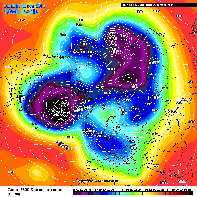
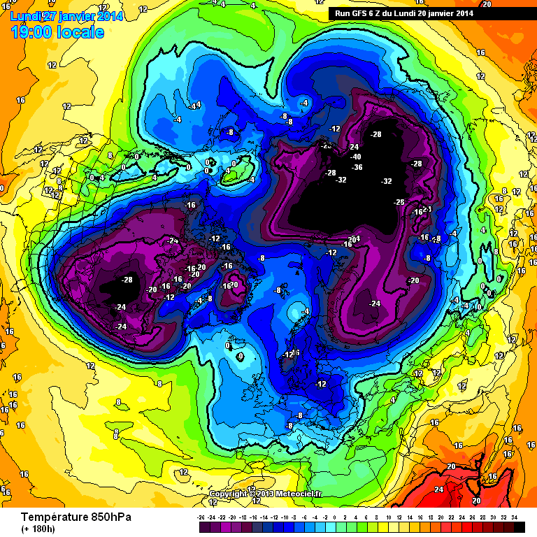
Looking towards Thursday, we see a split Polar Vortex, with incursions coming from the NW in quite a cool feeling flow.
Ensembles (Surface AVG Temps) (850's)
I am basing this on Nottingham to try and give a Balanced view N/S divide, although may vary.
Not looking beyond Thursday we can see the GFS Ensembles hovering from 0C - 5C, so quite average.
Although as noted, this will vary on City, for example, Aberdeen shows the cold filtering in quite a lot on Thursday.
Lets take a look at the 850's for comparison. I expect Aberdeen will be a lot lower due to the feed on Thursday coming through.
And Nottingham for comparison.
We can see a good agreement North and Mid/South for a drop in 850's, one to watch for potential snow events.
Other Charts
It's almost worth having a look at some other charts on offer. Unfortunately I have had to delete a load as this Forum wont allow more images to be added, but worth checking out latest SAT Images, NOAA Charts etc.
Cross Model Agreement?
GFS
ECMWF
Met Office
FAX Charts
It's also worth having a look at the FAX charts for forecasts T72 - They are one of the most reliable.
Thursday showing the interest, expecially with the 528 across much of the country (Sometimes needed for low level snow)
Conclusion
So, after taking all of that in, Tuesday/Wednesday remain wet throughout the day, feeling chilly and nothing really of note. Thursday see's quite a change from recent weeks (or months!) as cold air filters in from the WNW. Thursday is one to watch if it's snow you are after, and may perhaps, crop up a couple of surprises.
I have tried to keep this as simple as possible, especially for the newbies who will struggle in this thread with all the constant bickering, point scoring, and completely irrelevant one liner posts without backing anything up (Yes thats my rant, so have it). So hopefully you will understand a little more, and might have even learnt a thing or two.
Got to dash, there is a Fishing match live on Radio 4.
Glenn
-
40
-
- Popular Post
Right then... After feeling like I have spent a day at Kindergarten, I thought with the volatile situation we should focus more on the reliable timeframe, ~72 hours.
Most charts will be based on 09:00AM & I will try and keep this simple, mainly for the newbies struggling to keep up with this ever expanding thread.
It might make a nice chance from all the mad FI charts being shown which change during each run, so a nice change to normality at the reliable timeframe.
SPLITTING INTO TWO POSTS DUE TO TOO MANY IMAGES
Based mainly on the GFS.
Temperatures.
It looks like a chilly frosty morning for most except for the far soutwest, where temperatures will be quite mild to say the least.
It's a warmer start on Wednesday morning than Tuesday, with most places above freezing, except for high ground.
Most places hovering around 1-3C on Thursday, so feeling chilly.
Upper Air Temperatures
The upper air temperatures (850's) are also a little bit on the chilly side. Hovering between -2C and +3C for Tuesday.
Wednesday see's more of the same for the 850's.
Thursday is quite a bigger change than of late, with cold WNW winds flooding in.
Note, the 528 DAM line covering a lot of the UK - could be some snowfall around.
The Jetstream
The Jetstream remains in a quite slack flow as it heads towards the UK taking a more Southerly track on Tuesday.
On Wednesday, the JetStream appears to get powered into some life.
While Thursday sees all change with a powerful Jet flirting with the UK.
Stratosphere
We can see from the below image, some warming is beginning to take place, increasing pressure on the Polar Vortex.
Little change in regards to the temperature over a 3 day period.
This chart is showing the 30-hPa Zonal Mean for 2013-14.
Here is the ECMWF Strat chart.
We can also see the recent change at 10-hPa level over a small period of time.
Precipitation Charts
Tuesday starts off quite dry for most, which is always welcome in the UK, before rain begins to press in from the West.
A closer look at Tuesday for the UK shows some unwelcomed rain to many parts of the UK.
Wednesday starts off fairly dry for most besides some Eastern areas.
Parts of Northern England remain wet for the night.
Thursday morning begins with another front of Precipitation approching from the West.
Moving on we see the front move across the UK.
A closer look.
-
12
-
Sorry, best to just look at the thumbnails, the images are huge, except the first one.
-
My Lab...
-
Imagine this place if 10 years of winter was to appear lol!
Sounds very far fetched, but where is all the other texts? Surely a world wide event of darkness, snow & ice would have been wrote by someone else?
I call BS....
-
Potential for some Snow surprises on that chart, especially for higher area's, Pennines, Scotland and parts of the East., Worth keeping an eye on.
-
1
-
-
Bank.
GFS 12z 200114 Thickness 500-1000hpa & SLP at t+78.pngAt t+78 hours too, assuming there is precipitation around, a few of us would be happy with this. As ever, thereafter the GFS 12z wants to bulldoze the Jet in and push the Scandi High away, WE SHALL SEE!
Bank:
-
Little change in the ensemble means at 10 days out, cyclonic westerlies over UK. Seems to back up the Met Office outlook, signs of perhaps something stirring but this is a good best guess at the moment I think looking ahead until we see something more concrete showing with regards to a cold spell
NAEFS
ECM GEFS
GEM It's best to add Cold Westerlies with the potential for snow on them above charts. Although the feed is more a WNW.
-
1
-
-
Could you please explain the transient snowfall as you are referring to the GFS in your post.
A good few may see snow this weekend
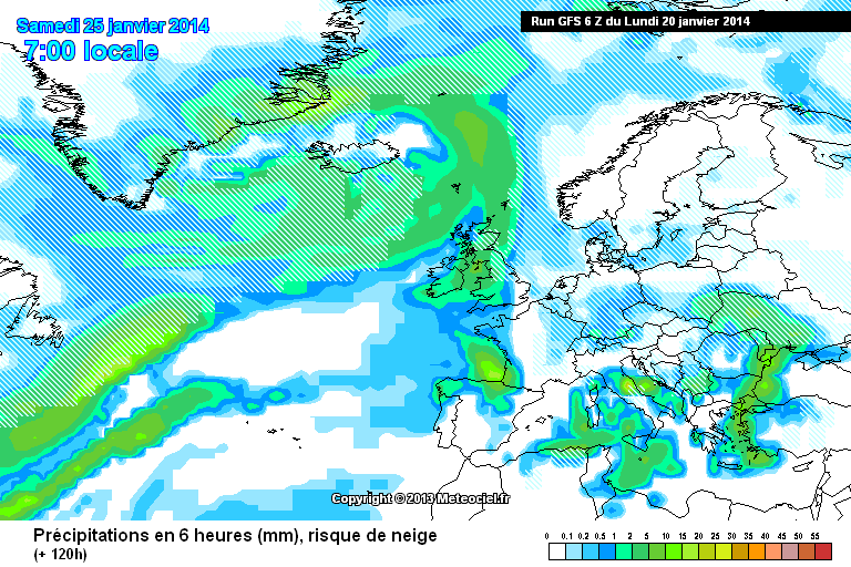
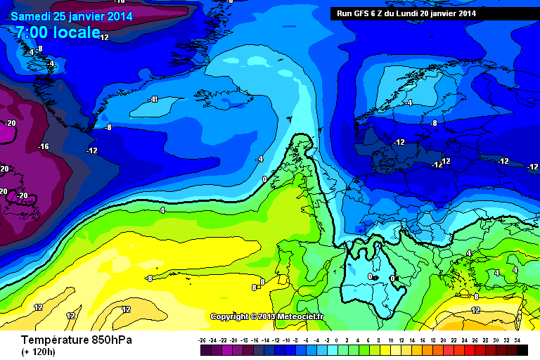
http://modeles.meteociel.fr/modeles/gfs/runs/2014012006/gfs-2-120.png?6
http://modeles.meteociel.fr/modeles/gfs/runs/2014012006/gfs-1-120.png?6
Mild air in the mix but not for long...
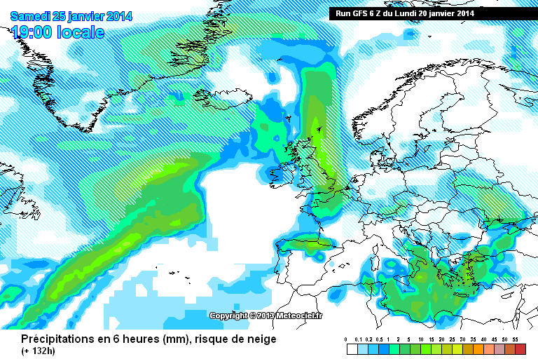
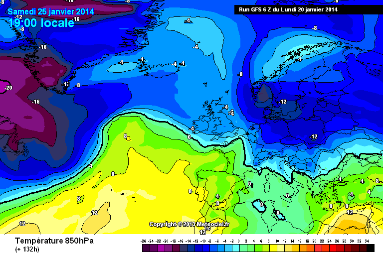
http://modeles.meteociel.fr/modeles/gfs/runs/2014012006/gfs-2-132.png?6
http://modeles.meteociel.fr/modeles/gfs/runs/2014012006/gfs-1-132.png?6
The PV maybe constantly showing but so is the Scandi high
http://modeles.meteociel.fr/modeles/gfs/runs/2014012006/gfsnh-0-180.png?6
http://modeles.meteociel.fr/modeles/gfs/runs/2014012006/gfsnh-1-180.png?6 There is no typical zonality on the 06z GFS to my eye.
and while ever it is
Just to back you up on that re most not getting snow:
-
4
-
-
What is the model output discussion thread for, is it cold hunting or discussing the model output whatever it may be, discussing what may happen whatever it may be? Some people find other types of weather interesting other than just cold, we have huge variety in our weather. Every post must be framed from the perspective of hunting cold or it's not welcome it seems... a very narrow definition of "model output discussion"?
It's for discussing the Model Output obviously, but unless you are wearing blinkers, some minority members seem dertermined to not point out what they actually show & vice versa.
-
1
-
-
Conflict there?
If the thread was "Model Hunt for Cold" then fair enough, hunt for cold and nobody else need discuss anything else. People find other types of weather interesting from a meteorological perspective however, gales, storms, thunderstorms, heavy rain, hail, convective weather etc, these people are shut out and have nowhere to go. Just would like somewhere where there's model discusson of weather in all it's variety rather than just one specialised type of weather. I suppose it's futile as nowt will change, ah well.
There is a slight conflict, but I don't mind because the usual good posters, Steve Murr, Nick S etc will say when it does not look good for cold, not just "make it up" for the fun of it, or look for the worst solution.
The ignore feature is a god send for that thread, although I hope there is not a quota because i'd be nearly there !!
-
- Popular Post
But your post inferred milder air in the sense of "no" cold. But that's not true, those charts, if verified, could bring a fair bit of snow to some areas.
Sorry, only seen his post through your quote, but we should balance this out considering it's London and one of the most southern points of the ENS.
Aberdeen:
BRRRRRRRRRRRRRRRRRRRRRRRRRRRRRRRRR
Yorkshire:
BRRRRRRRRRRRRRRRRRRRRRRRRRRRRRRR
Shetland:
BRRRRRRRRRRRRRRRRRRAAAAAAAAAAHHHHHHHHHHHHHHHHHHHHHHH
We can all pick & choose some charts which show different weather to suit our agenda, but one has to have a broad spectrum across different areas, and different models to make up your own mind.
The 27th is of certain interest... A few corrections here and there, coupled with the spiking of the precipitation forecast, someone could be in for a bit of a dumping:
-
15
-
Quite. Have often wondered whether the people who like filthy wet stormy weather would have a change of attitude if they were unfortunate enough to be flooded out of their homes, or have their roofs damaged by the wind. Perhaps its because said people have been fortunate enough to be unaffected by the foul winter we've had so far that they find such weather "interesting" or "exciting".
I'm not sure any of them really do actually like wet mush to be honest, most of them are just on a wind-up as 99% of people on this forum who use the Model Output are looking for Cold & Snow. Pretty sad behaviour really, but I don't see any of it anymore thanks to the Ignore feature where they all go. It makes the Model Output viewing much more enjoyable and none biased towards a particular weather type. It does not matter if there is -20 850's heading our way, they will find something to pick at.
-
2
-
-
Well Well Well, the 06Z is a stonker of a run towards the end in particular.
Battleground Situation:
Potential right there for some favourable areas re snow.
The cold wins out from the W/NW of all places:
The above is a very nice chart, expecially for Scotland and the North West of England.
Moving on we get full blow -5C's across the UK, the chance for snow just about anywhere:
As we move on into February, the cold is still around and snow could fall anywhere again:
Overall a fantastic set of charts from the 06Z after a quite shaky start, and finally a possible end showing to the drab of wet and mildish weather. Certainly nothing Zonal or remotely mild being offered in the charts at the moment from 4-5 days onwards.
-
7
-
-
Pennine / Peak Areas should do well from this:
Not overly convinced by the 06Z - It pretty much follows the 00Z, so we have some consistency at least. Albeit i don't see much in the way of corrections West ?
Lots more cold pooling into more Southern parts of Europe on this run, compared to the 00Z.
00Z:
06Z
-5 850's also moving in from the west a lot quicker than the 00Z.
Small potential SE UK for snow:
Not a bad run so far.
-
2
-
-
GFS 00z is a colder run with out doubt as the 8 day temperature anomaly shows
Quite a change that Gav from a couple of days ago. That is VERY cold, and Europe is freezing over as well.
I don't hold these charts in high regard though because of the amount of chopping & changing they do on a daily basis, but it does tie in nicely with the current output. Long way to go though yet !
Looking ahead around the same time period, we almost have a countrywide snow event:
-
4
-
-
Freezing last night - pipe froze and burst at work, toilets flooded !
More of the same please. Cold & Snowy end to Jan on the cards. No mildy in sight, finally !
-
I know it's been a horrible Winter so far, but keep the faith, things will change.
27th showing a good unstable NW feed in -6 or -8C upper air. This would bring snow to most of us in Northern England, Pennines and NW England.
Long way off no doubt, but the trend is there.
-
1
-


 ECM
ECM 
 GEM
GEM 


North West Regional Weather Discussion 07/01/14
in Regional
Posted
Fergie.