


R.P. McMurphy
-
Posts
1,833 -
Joined
-
Last visited
Content Type
Forums
Blogs
Gallery
Events
Learn About Weather and Meteorology
Community guides
Posts posted by R.P. McMurphy
-
-

If only Models were 100% correct way out into FI...
All this talk of Look East.... Look NORTH.
Lets hope the trend continues.
-
 7
7
-
-
Sorry, the statement in bold is just false. The winter so far has been very mild as indicated in the CET:
December 2013: 6.3C
January 2014 (to date): 6.2C
How is that Very Mild ? I think you may be reading them wrong.
The current CET is 6.2C for January, the average is roughly 4.2C, so thats just 2C above average.
NB - The data is generally taken from the Midlands Area. There has been quite a split/stark difference also with North/South divide. 2C above normal is no where near very mild.
Would you consider the North Pole at -50C and in 2014 it was -48C - Is that very mild?
-
1
-
-
Actually as of last night, 50% of MOGREPS members heralded an easterly by next Fri and that suite is currently exhibiting near record high levels of Shannon entropy out through day 10 onward. Given some support (albeit still minority) in EC ENS for cut-off low to SE and easterly feed, UKMO urging caution on being too prescriptive end of next week onwards, despite majority westerly solutions. In short: nothing yet discounted.
Hi Ian,
Thats quite a turnaround from a few days ago of less than 10% I believe it was ? What has changed ?
A lot of members throwing around the term Shannon Entropy as of late. If you try and Google what this means, it offers very little of understanding !
I believe, and correct me if I am wrong anyone, what Ian F refers to an output the DECIDER model from the Met Office ?
I found the following chart:
So we can see what Ian is referring to re "Record Highest Entropy" - I am not sure if this is still the latest record or not.
For those with slightly poorer vision, albeit it's difficult to read with 20/20 vision, the text on the image states:
High Entropies indicate a wide diversity of synoptic types across the ensemble members.
Low Entropies indicate that most ensemble members fall into a small number if synoptic types.
So basically, High Entropies = Several outcomes possible (In this case 50/50 Easterley VS Atlantic)
Low Entropies = Smaller number of outcomes
**If this is wrong, someone can correct me !!**
Hope this helps, as it sure helped me.
Glenn
-
8
-
-
Could be worse, you could live in Cairo where it's almost impossible to get snow.... Oh, wait...
-
1
-
-
Latest GFS 8 day temperature anomaly, lots of cold building for eastern and north eastern Europe now, for the UK its a mixed bag slightly below normal for the north and Ireland, but slightly above normal for the south, some western coasts and Wales
Gav, just to point out thats not above normal for the south - it's 0.2 - 2C mate, while the rest of the UK remains below.
-
1
-
-
Lots of deep cold building into Russia and Scandianvia.
UK Remaining around 0C - 5C.
-
I think the low res has lost the plot a bit here... I think if it went further, you would see a greenland high followed by a Northerley.
PV completely left Canada.
-
Well I said it earlier the 18z is going to provide a few surprises. Amazing differences already, they are really, really struggling.
-
1
-
-
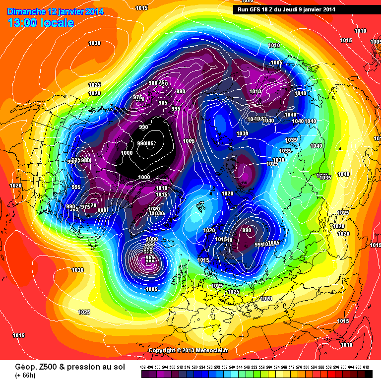
http://modeles.meteociel.fr/modeles/gfs/runs/2014010918/gfsnh-0-66.png?18
A sign of trough disruption @ 66.
S
Lets hope for a good 18Z - I don't think next week is set in stone yet, far from it. Trough dist is a good sign to start with /opfc/atm/mogreps-uk/prods/201412.file/prods_op_mogreps-uk_201412_21_
Not much change yet,
Low slightly more stretched.
-
if anyone posts that the T240 ecm shows potential ..................................
Depends what your looking for or how you are defining "potential"...
If its a VB track, and warm winds are your thing, it's got great potential.
-
I
Odd looking charts from the ECM, warm air being pumped up from N. Africa, certainly not cold.
It's not that odd - it's because of the lows in Iberia, pumping up the air.
Oh and just to add, it will certainly feel cold with that feed. Just not cold enough for snow. It's the 850's that will be high.
-
1
-
-
No its going South & SW towards the azores on the 12z ECM-
needs to be SSE
at least the scandi high is still there @ 192.
S
Yup, as long as the pressure remains over Scandi, we always have a shot at getting cold weather...
-
1
-
-
Surely this can`t be right, the low pressure all but vanishes south.
Edit: wrong chart.
Well thats interesting. Instead of it just going right through and destroying all hopes, it sinks completely south....
Hmmmm
-
Great chart... It's turning.
-
1
-
-
Well ECMWF is a little better, and elongates the low some more...
Tomorrow is the day we smile again...
-
Looks like the 12z want us bring mild and very wet weather back. Just sick of it. It won't help either and only bring more misery to the country.
SCREW YOU ATLANTIC AND GO BACK TO HIBERNATION!!
Yep, models quite poor today... But, looking at the Pertubations and the Ens, I don't think we are quite done here...
I'm expecting something completely different tomorrow, if not tonight from the ECM and 18Z GFS....
Lets see....
-
1
-
-
funny ..my prediction for this winter was 3 months of extra autumn ...
Well you're 1/3 and a half the way there !
So does Winter start in March/April?
-
-
Yep, back tracking charts, Met Office latest update is a right kick in the betty swollocks.
Can they be wrong? Who knows... Another phantom Easterley? Usually suck for our area anyways.
Greeny high, N or NW winds = yummy.
-
3
-
-
The hills around here have been white with snow about four or five times this winter and ladybower on boxing day was foggy and frosty but wintry and festive..... There was snow on the snake pass and it was pretty icy.... A car had slid off the road into the marsh oooppsss....
Ohh thats nasty. I know how dangerous it can be up there.
What's it like in Glossop/Peaks - any snow or just all dry?
Still looking at that Longdendale trail - Thats the one that goes right round that resouviour isn't it ? Looks really nice & scenic, perfect for me and the Dog.
-
1
-
-
Longdendale trail good for dog walking.... Beehive, bulls head, and there a nice wine/ beer bar thats opened near the globe pub.... This weekends looking like its cooler but sunny so mite be out on my bike round ladybower....This might be useful also.....http://www.walkinginderbyshire.co.uk/glossop.php
Thanks for that, that Longdendale trail looks really nice - might be a bit wintry this/next weekend you never know !!
Has it snowed up there at all, all winter yet?
-
What is wrong with you Happydays/Cecil?
-
Think you could be right - a downgrade had to happen after I told the guys in the pub it'll be wintry down here next week...doh
It's a good job it's just his feeling then !
-
Interesting.....supossedly its 9c at manchester airport...it was 6c at denton coming back in car, 4c here now...2c just north of here.....could, as gfs have north of here, evap cooling come into play tonight?Its hammering it down outside atm....
Coming to Glossop maybe this weekend or next for a walk with the Dog.. Anywhere recommended?


Model Output Discussion - 10th Jan Onwards
in Forecast Model Discussion
Posted
Cold & Snowy for Midlands Northwards on this run. Pennine Areas, Northern/North Western England Especially in that convective flow. The trend is there...
Lots of scatter towards the end, but firming up on agreement, the cold is on it's way.