


summer blizzard
-
Posts
18,606 -
Joined
-
Last visited
-
Days Won
9
Content Type
Forums
Blogs
Gallery
Events
Learn About Weather and Meteorology
Community guides
Posts posted by summer blizzard
-
-
Still expect the Weds/Thurs low to prevail however it's worth saying that the UKMO 0Z and GFS 6Z both fail on Monday now.

-
 2
2
-
 1
1
-
-
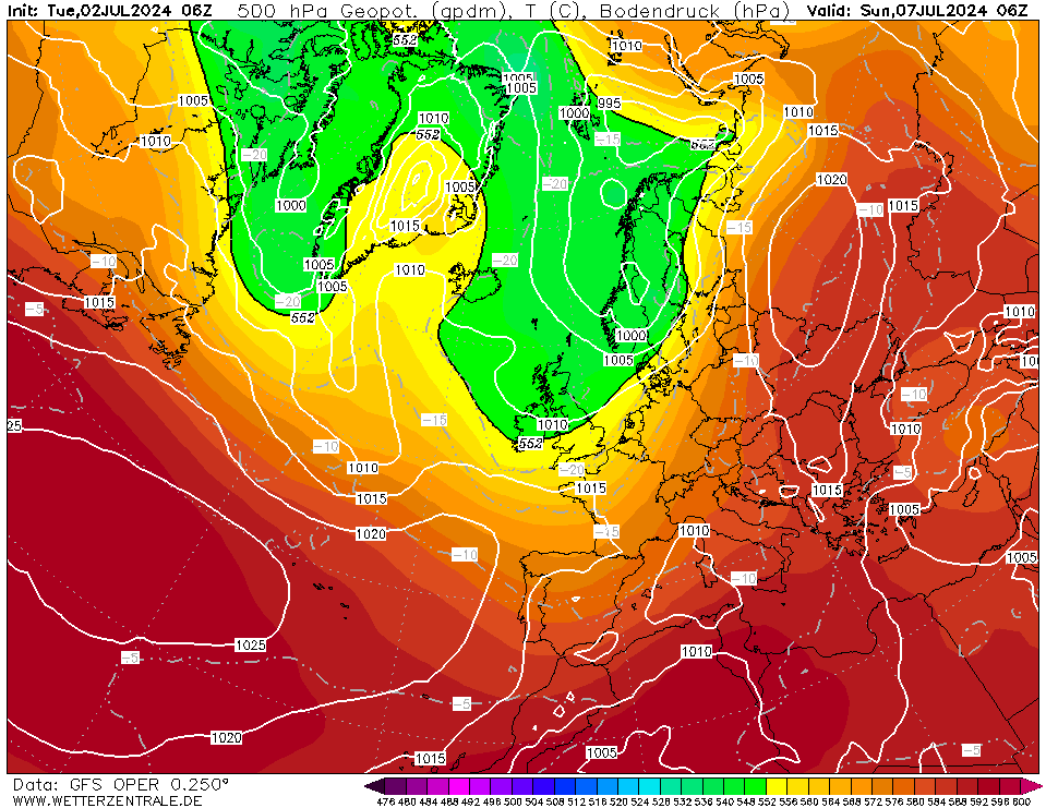
Some differences over the past day or two.
The Mon-Tues Low now only really gets half a job done (bar the Euro which has it win outright).
All models agree that its the weds/thurs low which now prevails fully (bar Euro which already got the job done).
However differences have emerged with the low afterwards. Euro is zonal, GFS0z was a half way house however the GEM goes under.
-
4
-
-
Do the models suggest any notable shower activity over the next day or two.
-
Snow here.
Third out of 4 years (can't quite remember if it snowed at the end last year).
-
49 minutes ago, damianslaw said:
Just 3 days left of November. I've not read many thoughts on winter ahead. Good to hear thoughts.
Cold. I'm bullish for the first time in years
November has gone about as expected and I previously forecast a fairly average December and February with a cold Jan and March but it looks like December is coming in colder than expected.
-
2
-
-
31 minutes ago, TSNWK said:
is this good or bad for longivity?
Good.
There are basically three ways to kill the cold spell.
1) Local spoiler similar to last year, blow up a secondary low somewhere over or west of us and unfortunately it will suck up some warm air most likely. At least enough to displace the cool air.
2) High pressure can topple. This is unfortunately what often happens when we end up with a snowless breakdown because the high sucks in warm upper air and the cool surface air moderates.
3) Atlantic front, low pressure moves in and washes away the cold spell.
If an Atlantic Low can't pass southern Greenland at strength then you pretty much rule out option three.
Original post: https://community.netweather.tv/topic/99584-model-output-discussion-into-winter/?do=findComment&comment=4961127 -
31 minutes ago, TSNWK said:
is this good or bad for longivity?
Good.
There are basically three ways to kill the cold spell.
1) Local spoiler similar to last year, blow up a secondary low somewhere over or west of us and unfortunately it will suck up some warm air most likely. At least enough to displace the cool air.
2) High pressure can topple. This is unfortunately what often happens when we end up with a snowless breakdown because the high sucks in warm upper air and the cool surface air moderates.
3) Atlantic front, low pressure moves in and washes away the cold spell.
If an Atlantic Low can't pass southern Greenland at strength then you pretty much rule out option three.
-
3
-
 3
3
-
-
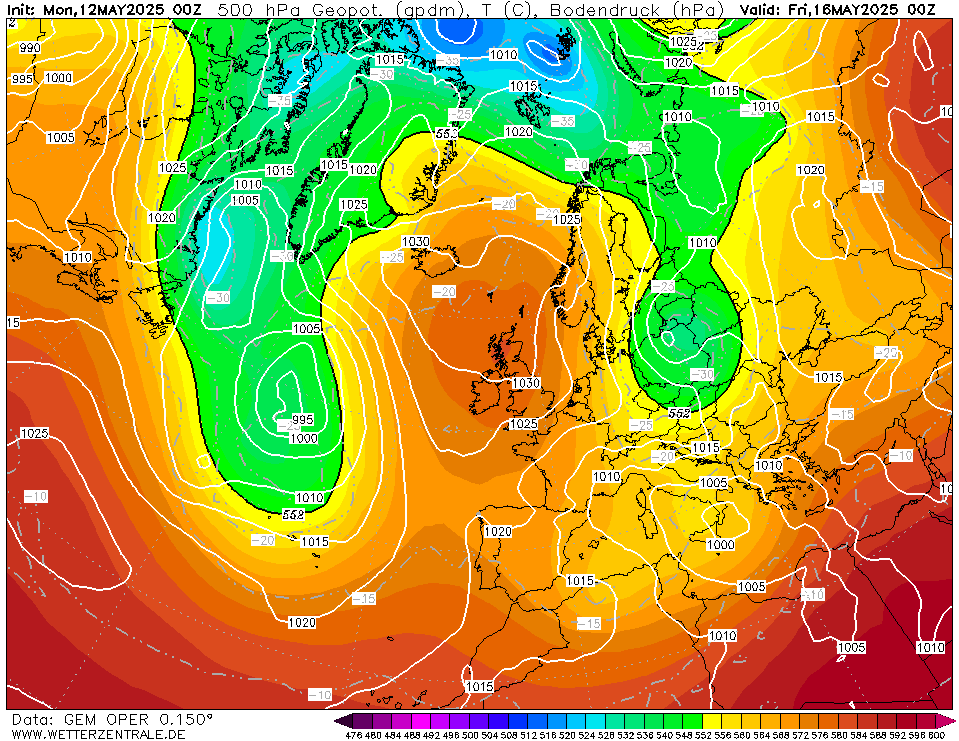
Euro still does not get a sub 1000mb low past southern Greenland until day 8 (a day slower than yesterday) and then actually kills it. Euro ensemble mean is as weak through day 10.
-
2
-
-
5.6C, 74mm
Suspect this will be wrong given the outlook but i will stick with my normal methods.
-
Personally don't see much in the models to concern me at the moment. One of the little tricks i have learnt over the years in these situations where a cold spell is embedded, is to see how long it takes the models to get a sub-1000mb low past the southern tip of Greenland. Euro0z, GFS0z and GFS6z say day 8, GEM0z says day 10.
That firstly confirms that messy setup here aside, there is no threat this side of day 8. Secondly, that's beyond the point at which models have 50% model skill. Indeed the GFS ensemble means for the 0z and 6z suggest this does not happen until 9, the Euro ensemble mean says it does not happen through day 10 (i.e. even the operational was more progressive than the mean).
Notably, even the agressive GFS means by day 10 still have a 1035mb ridge over Greenland which at day 10 when runs should be reverting to the mean (westerly and +AO) is quite something.
Moral of the story is that since we generally see weaker and slower closer to the time, i would tend to back the Euro ensemble mean on this occasion which means that the blocking likely sustains beyond 6th December.
In terms of the more speculative future..
1) As the GFS kind of highlights in FI, even if the breakdown comes, i'm not entirely certain the Atlantic will be strong enough to progress and so a UK/Sceuro ridge would not shock me albeit there's not much long term support so it may degrade into Atantic westerlies.
As alluded by Catacol earlier, it looks like the next Pacific wave will be crossing the dateline around the 10th and while i doubt GFS has the amplitude correct (normally too strong), it should encourage blocking into Greenland so i would look for this signal in the models to strengthen during the third week of December, especially if both the stratosphere and troposphere are not hostile.
Original post: https://community.netweather.tv/topic/99428-model-output-discussion-mid-autumn/?do=findComment&comment=4959744 -
- Popular Post
- Popular Post
Personally don't see much in the models to concern me at the moment. One of the little tricks i have learnt over the years in these situations where a cold spell is embedded, is to see how long it takes the models to get a sub-1000mb low past the southern tip of Greenland. Euro0z, GFS0z and GFS6z say day 8, GEM0z says day 10.
That firstly confirms that messy setup here aside, there is no threat this side of day 8. Secondly, that's beyond the point at which models have 50% model skill. Indeed the GFS ensemble means for the 0z and 6z suggest this does not happen until 9, the Euro ensemble mean says it does not happen through day 10 (i.e. even the operational was more progressive than the mean).
Notably, even the agressive GFS means by day 10 still have a 1035mb ridge over Greenland which at day 10 when runs should be reverting to the mean (westerly and +AO) is quite something.
Moral of the story is that since we generally see weaker and slower closer to the time, i would tend to back the Euro ensemble mean on this occasion which means that the blocking likely sustains beyond 6th December.
In terms of the more speculative future..
1) As the GFS kind of highlights in FI, even if the breakdown comes, i'm not entirely certain the Atlantic will be strong enough to progress and so a UK/Sceuro ridge would not shock me albeit there's not much long term support so it may degrade into Atantic westerlies.
As alluded by Catacol earlier, it looks like the next Pacific wave will be crossing the dateline around the 10th and while i doubt GFS has the amplitude correct (normally too strong), it should encourage blocking into Greenland so i would look for this signal in the models to strengthen during the third week of December, especially if both the stratosphere and troposphere are not hostile.
-
18
-
8
-
9 hours ago, IrelandWeather said:
I'm curious why so many keep saying these are the best early winter charts for years/best start to winter.
Was I hallucinating last year? It's been a year. One year since a good start to winter. And the model output for the above began in November too, and there were plenty of runs which showed potential of an even better spell of weather. The charts from last year rival nearly anything popping up currently, unfortunately we just did not get all the hoped embedded features so many didn't see snowy conditions. But still, you can't even argue that last years spell wasn't as good, because this years hasn't even happened yet and could end up even worse (or better, who knows). Some snow, prolonged cold, ice days...coldest spell of December weather since 2010.
It's been tossed around so much the last week and it's a bit funny. I wouldn't say it (Dec 22 spell) was classic at all here in Ireland, but given nothing has happened yet it would be strange to say that this is the best start to winter since 2010. But hey, different strokes.
This is a good point and i think it mainly stems from the fact that it was a snow poor event for many, especially given the southern bias from many. It's also worth saying that last year did not produce its sub zero daily mean until the 7th. It's somewhat like Feb 12 i suppose or winter 06 which are both rarely spoken of despite their statistical impressivness.
-
1
-
-
Regarding the SSW hunt, for those who want an early event like 2013 or 2021 its worth saying that the CFS is showing the next strong wave event in the Pacific passing between the 10th-20th December which should increase poleward heat flux. While the strength is not something i'd focus on with CFS, the timing should not be off. Given that we are early in the season though, we probably have to wait another ~month for the passage after but it's worth an eye on given that the vortex is already in some distress (or forecast to be) rather than continuing to cool and strengthen.
-
2
-
-
11 minutes ago, rwtwm said:
You're not the only person to make this statement. But it's worth reminding everyone that the first half of last December was the coldest since 2010 - sample analysis charts from Dec '22 below.
Separately, was it 2019/20 that started with a really disorganised vortex, then an SSW threw us into a mild high?
Can't help but be reminded of that (even if I have the year wrong), when I see excited posts about an SSW against this starting point.
Of course, there's still time for everything to flatten out. But looking naively at the 00z ensembles it's looking promising that a second consecutive winter will start with a below average spell.
The winter of 2020 did not see a SSW. People are perhaps remembering 18/19 which saw a SSW in very early January however December was already mild. Quiite a lot of SSW's do just generate a 2 week polar block before a UK high for a month (2009, 2013, 2019), additional cold if it comes is from another attack on a weak ish vortex.
-
2
-
-
3 minutes ago, Mike Poole said:
I think it is definitely connected with the connecting ridge through Scandi into Russia, as that only appeared in the modelling yesterday, and today the models seem confident about it. For a good fortnight previously, high pressure had vanished from that area and the strat warming threat had receded on the ECM 46 accordingly. It’s back now!
Re, the tripole, is it known if the tripole has emerged because of the southerly tracking jet (which has been so for a while now on average), or is the southerly tracking jet caused by the tripole?
Tripole is chicken and egg.
But it's worth saying that while there is a tripole it's further north than is optimum (whether this impacts the pattern down the line is speculative of course).
-
1
-
1
-
-
15NOV2023: Nino3: 2.1 , Nino3.4: 1.9 , Nino4: 1.5
-
Nino is now very close to peak.
Basically, that blob of 30C SST has been proceeding east (and weakening) as the west Pacific has cooled faster than the ENSO zones being sustained from the east. As it is clearing the main Nino zones over the next month or so, GFS is suggesting that the weak standing wave observed over the west pacific since the end of the moonsoon will shift east towards the dateline (and in turn, Nino 3) however the enhanced easterlies behind it will likely cool Nino 4 (then 3) as this happens like we see in the West Pacific.
Above is the pattern since the monsoon ended and ENSO/IOD had a greater impact on the pattern.
Above here though is the GFS forecast showing a shift east (also indicated on a Euro forecast plot posted by Matt Hugo in another thread).
..
As allided to above, persistent convection in this region could see December (and possibly January) peak warmer than they are now however as Nino 4 drops, we will start to see the warming in Nino 3 cancelled out, especially as the wave should progressively weaken as it moves. As such this sugests that we are quite close to peak now in Nino 4 and somewhere close in Nino 3 (the 90 day chart suggests a month or so before the pattern shifts east on its journey).
For winter purposes it's a mixed bag. If forcing nudges east with it then it favours MJO 6-7-8-1 which are good (at least compared to phases 4-5) however relaxed trades in the Indian Ocean can also encourage phases 2-3 which are not always great (wrong place to support -AO normally). The Aleutian Low is also normally in the mean close to directly north of the primary forcing and generally the further west the better.
-
3
-
-
On 14/11/2023 at 16:47, toggerob said:
A video taken yesterday inside Grindavik before today's immediate evac of the town, at least the Icelandic Authorities are now actively monitoring the emissions of SO2/CO2 and can use the data to build a better picture into their model-runs depicting where and how close the magma is to the surface. I've heard estimates of 5km, 800m, a few 'tens of meters' etc but in reality all anyone can do is wait and see.
Basically its a magma tube moving SW and at its weakest point it allowed magma to rise to 800m. As Pit suggests though, it looks like we have lost the current pressure for now.
-
1
-
-
08NOV2023: Nino3: 2.0 , Nino3.4: 1.8 , Nino4: 1.3
Outlook is for another nudge up over the next week or two before stable or cooling.
http://www.atmos.albany.edu/student/ventrice/real_time/timeLon/u.anom.30.5S-5N.gif
-
GFS18z stays with it.
-
15 minutes ago, Cheshire Freeze said:
Seems the signs are pointing towards a Feb SSW to me…however i hope to be wrong and that it happens early Jan instead!
My primary analogues go Jan 9th to Feb 13th.
Not a bad sign to be honest, mid rather than late winter.
Coldest in Jan and March too.
-
2
-
-
Just now, bluearmy said:
Some 12z ops are going with a n pacific or Aleutian ridge - some aren’t
No, flatter.
-
- Popular Post
- Popular Post
GFS6z attempts to do its best Nov 05 impression developing a UK High and 'faux cold' as some call it via potential inversions due to cool, dry air (high soil moisture probably means fog too).
-
10
-
Personally i don't concern myself with coupling, its standard fare and abnormal when it does not. So long as the stratosphere does not remain hostile to our interests, it's not a concern outside December and actually a good thing if a SSW actually occurs as it can downwell more effectively than occasions where it tilts due to poor coupling.
Also, something that has not been spoken of much but there is now some evidence that one of the two solar hemispheres may have peaked in June (month on month drops since). It's not referred to much but quite a few solar cycles actually have a double peak because the solar hemispheres can be as much as two years apart (would suggest full solar maximum by Spring 2025).
-
1
-
1
-


E.N.S.O. Discussion
in Spring Weather Discussion
Posted
22NOV2023: Nino3: 2.3 , Nino3.4: 2.1 , Nino4: 1.5