


summer blizzard
-
Posts
18,635 -
Joined
-
Last visited
-
Days Won
9
Content Type
Forums
Blogs
Gallery
Events
Learn About Weather and Meteorology
Community guides
Posts posted by summer blizzard
-
-
Rolling CET for November-October fell to 10.92C. Probably close to the end result since November and December should be close to cancelling each other out bar any abnormaility.
-
Personally i don't expect the Euro 0z today to be correct and think that the GEM/GFS0z will be closer to the mark.
Essentially, there are some years like summer 2022 where the weather is completely confounding (at least to me) however since late summer, our weather (though a higher amplitude scale) has done exactly what i'd expect it do based on topical convection. That basically supports our northern blocking lapsing by the time we end week 1 (so fine with the model on that) but then something more akin to blocking to the north and east (so a Scandinavian or Sceuro High) for week 2 before the pattern cycles again (trough to the south/west) for week 3. As such, i don't really buy the current modelling of full on zonality and suspect this will weaken (you can see that the GFS0z and GEM0z could go down the route i expect).
-
 4
4
-
-
Interesting tropical profile during October. You can see that we have cycling through Pacific waves with a dead Indian Ocean (loosely, MJO phases 4-5-6-7-8-1) however this has been superimposed with a retrograde standing wave.

Original post: https://community.netweather.tv/topic/99428-model-output-discussion-mid-autumn/?do=findComment&comment=4945155 -
Interesting tropical profile during October. You can see that we have cycling through Pacific waves with a dead Indian Ocean (loosely, MJO phases 4-5-6-7-8-1) however this has been superimposed with a retrograde standing wave.
-
1
-
 3
3
-
-
25OCT2023: Nino3: 2.0 , Nino3.4: 1.6 , Nino4: 1.3
October ONI should come in at +1.6.
ASO ONI likely to come in around +1.5.
-
Is that for Dec-Feb.
-
11 minutes ago, Don said:
Another potential positive is that the sun seems to be rather sleepy at the moment, too?
No, near solar maxima.
-
-
Important to note that the CET only correlates with the AO about 70% of the time and the AO is not negative for long after 100% of SSW events. Hence the reasonable expectation being more like two thirds of the time for a favourable impact (though as the likes of Jan 19 show, if the background pattern is hostile then it's not going to do much more than give you a reasonably cool spell).
In terms of polar vortex formation there are a few ways to think of it and I have never been sold on either fully. Basically there is the view that if the trop and strat are disconnected from the off then you need less of a punch and can kill the vortex fairly quickly - I am not sold on this because most winters see the vortex rebound after early warming events and for scientific reasons, once you get a big vortex hit, it tends to stop the pressure building up again so most winters don't then see sustained pressure. The second idea is essentially that actually so long as it's near average and not raging, a coupled trop and strat are actually beneficial in that if the strat then becomes disturbed the impact is felt through the troposphere.
It's also worth remembering that polar vortex strength is not the only thing that dictates our weather. Notably, as we entered both December 2016 and 2017 i recall people being very excited because the vortex was very weak, in the end both cases saw the vortex rebound and neither December was anything special. We did get the second hit in Feb 18 but nothing in winter 17. Likewise, you have cases like winter 2012 whereby after a fairly zonal November and December 2011, we saw a failed SSW in January (vortex did drop to single digits) but actually that was enough to produce the coldest first half to February since probably the 90's.
Point being, people should calm themselves when thinking about the polar vortex and SSW. I'm a big fan of the idea that the overall background can create a 'kind troposphere' as was the case in winter 08/09 when the vortex weakness was nothing special pre-SSW but winter delivered on a scale not seen in over a decade or of course, a hostile troposphere whereby a winter which on the surface has good telleconective patterns ends up underperforming.
-
2
-
-
18OCT2023: Nino3: 2.1 , Nino3.4: 1.6 , Nino4: 1.3
-
-
I would still urge caution, I think that far too many of you are far too optimistic.
That said, I do expect Q1 to average colder than average.
-
1
-
-
1 hour ago, Summer8906 said:
Which does make you wonder whether, eventually, the jetstream will go so far south that it leaves us in a dry easterly, as happened in both the above examples.
09 did not really have the same setup. November was dominated by a Sceuro block and south westerlies which was replaced by an Atlantic High before retrogression brought the great cold spell.
While less stormy, this is more like 2000 or 2019 which basically saw a cyclonic stream on a fairly southerly track.
26 minutes ago, CoventryWeather said:Was 09/10 winter one of constant cold spells? Questioned on model thread too.
Yes. The first half of December was cool and anticyclonic. The second half of Dec to Mid January was sub zero CET and snowy. The second half of Feb was also snowy.-
1
-
-
6 hours ago, Chesil View said:
Crikey. Blocking Highs and easterly winds being mentioned in the meto 15 to 30 day outlook.!!

Interesting.
That suggests that there is strong support in the long range Euro ensembles and Glosea.
-
1
-
-
11OCT2023: Nino3: 2.1 , Nino3.4: 1.5 , Nino4: 1.3
-
13 hours ago, Metwatch said:
I would say a desert climate but close to / islands in the Atlantic or Pacific ocean is most natural / ideal with a moderation in extreme summer heat, but then the issue of a lack of fresh rainwater arises which in turn means little vegetation and wildlife in general. Very difficult to find the ideal climate on land where you can survive without an insulated home, when there's enough warmth year around, no extreme warmth or extreme cold, while ALSO with some rain.
Tropical savannah or tropical rainforest / monsoon comes to mind, a lot of tribes live in those sort of areas (Africa, south America etc) with not much clothing and homes, mainly to shelter from rain and predators rather than insulate from cold temperatures. However a lot of us who are used to temperate weather most of the year wouldn't be used to the humidity in those climates.
Thinking about it, a lot of the coastal mediterranean areas such as the Spanish part is fairly ideal, rainfall mainly in winter, though a bit hot in summer, it's usually bearable for most.
If we are talking about humans in nature then i'd agree with the assertion that we are a tropical species. When you take away proper clothing and shelter, only the tropicals remain viable year round (the moisture prevents absurd maxima and cold nights).
If we are talking about humans as we are (i.e. clothed and sheltered) then i would say that the southern temperate zone is most hospitable. We don't cope well naturally with sub 10C minima or plus 40C maxima especially well (without modern technology to support large populations).
I would therefore suggest that southern France and northern Italy are probably much more ideal in that regard.
-
1
-
 1
1
-
-
Can't post the chart currently (phone won't copy and paste) but the GFS is suggesting a strong wave progressing through the Pacific in around 2 weeks so i'd look for the first week of November to see another pressure build over Scandinavia unless there's more change.
-
5
-
-
12.4C is required to avoid the top 11.
-
1 hour ago, TSNWK said:
Still plenty of heights to our north and not sign of the vortex just yet
Basically it illustrates the position (and forecast) of anomolous westerlies (convection) and easterlies (subsidence) in the Pacific, close to the equator. When you have two areas that are competing, this makes things harder to forecast because it's abnormal.
-
2
-
3
-
-
Cold enough for ground frost on cars in BD19.
-
We appear to have concensus now that our E/SE spell will be followed with an Atlantic pattern to day 10.
Personally i wonder if we are not seeing competing signals for week 4. You can see in the chart below that we have standing waves trying to form in both the west and east Pacific.
-
2
-
-
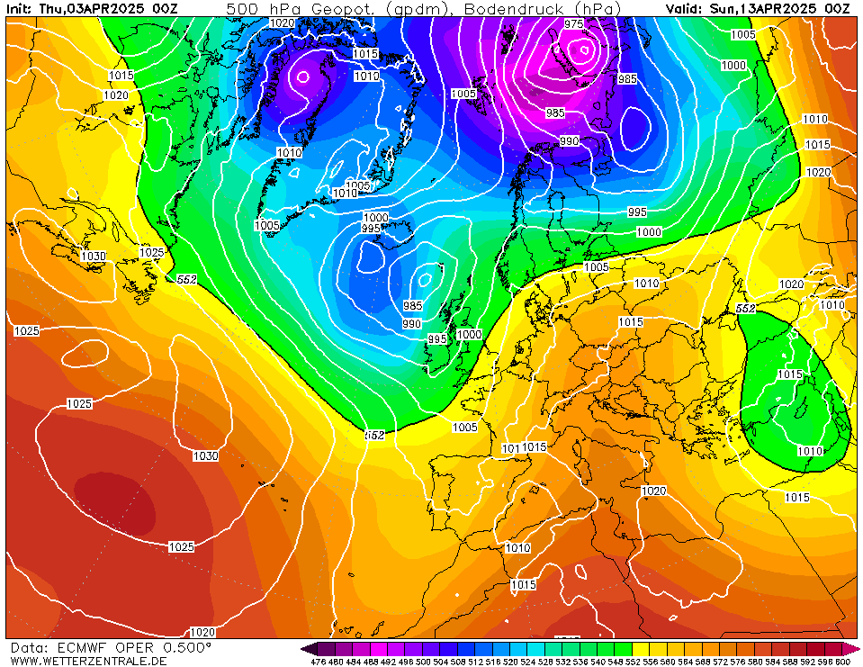
Euro this morning does not quite transfer the Greenland energy into Russia and so the block sinks, we are then waiting in limbo for an Atlantic trough.
GEM is a success and retrogresses to Greenland and does its best floppy easterly to floppy northerly impression.
GFS0z was basically a wet version of the GEM. We get the heights over Greenland but the transfer is weaker meaning that we end up with a flabby low slowly moving east.
GFS6z is much the same with a stronger Atlantic.
I would tend to discount the GFS6z since the other runs keep the Atlantic weak but it does look like the Scandi High will move away quite quickly. Uncertain as yet whether or not this produces a Greenland block strong enough to keep the UK especially cool.
-
2
-
-
September PDO came in at at -2.94, the lowest September value since 2012.
September AO came in at +0.3, the highest September value since 2020.
September QBO came in at -0.6, the lowest September value since 2021.
September MEI came in at +0.6, the highest September value since 2015.
-
1
-
-
UKMO has the second low at day 7 at 970mb so its likely to fail.
GEM succeeded in pushing through by day 9 with the second low as the Scandi Ridge moves towards Greenland.
GFS0z was a horrid halfway house, it pushed the second low through but the low was already at our lattitude so we don't get the fresh continental air (recipe for 10C and cloud all day and night).
GFS6z was a fail, the Atlantic wins by day 10 (ignoring FI afterwards).
Euro is a fail overall although only just.


Model Output Discussion - mid Autumn
in Forecast Model Discussion
Posted
GEM going for the pressure build to the north/east option as i alluded to earlier.